Clach Brath, Baile Mor, Iona

Bullaun Stone:  OS Grid Reference – NM 286 244

Also known as:

  1. Clacha Brath
  2. Clachan-nan-Druidhean
  3. Day of Judgement Stone
  4. Druid’s Stone
  5. World’s End Stone

Folklore

On this curious, broken, basin-shaped rock — thought by some to have at one time played a part in an old cross whose remains are in the Abbey Museum — are two deep cup-shaped hollows, in which were once “three noble globes of white marble” that were used for oracular purposes and were said to have originated in druidical rites.  In Miss McNeill’s (1954) survey of the island, she tells that:

“near the edge of the path leading to St. Oran’s Chapel, there lies a broad, flat stone, with a slit and a cavity on its surface. Here there used to lie some small round stones which pilgrims were wont to turn sunwise within the cavity; for it was commonly believed that the ‘brath’, or end of the world, would not arrive until this stone should be worn through.”

The small stones that were once in the Brath were ordered by the Church to be thrown into the sea; but local folk replaced them with three other small stones, maintaining the traditional rites of this stone until they eventually stopped sometime in the 19th century.  But in Major-General James Forlong’s (1906) study, he tells of a somewhat earlier mythic origin to this old stone, saying:

“In Iona the Druids are said to have made the flat altar stone called Clachan-nan-Druidhean, or Druid’s Stone, the stone of fate or of the last day, with round stones fitted into cup hollows on the surface, which the pious pilgrim turns round.  The world will end when the stone is worn through.  The Culdee monks preserved this monument.”

And what little is left is still preserved to this day.  The curious “end of the world” motif was something that was grafted onto an earlier mythos: what Mircea Eliade called the “myth of the eternal return”, wherein Nature’s annual cycle —from birth, life to death and subsequent renewal, endlessly, through the seasons—was the original status, later transmuted by the incoming judaeo-christian cult of linear time and milleniumism relating to a literal “end of the world” when their profane myth of Jesus returning to Earth occurs.  We might also add that the stones which once rested into the hollows of the Clach Brath would likely have possessed divinatory and healing qualities, as comparatiove studies suggest.

References:

  1. Eliade, Mircea, The Myth of the Eternal Return,
  2. Forlong, J.G.S., Faiths of Man – volume 1, Bernard Quarithc: London 1906.
  3. Holder, Geoff, The Guide to Mysterious Iona and Staffa, Tempus: Stroud 2001.
  4. McNeill, F. Marion, Iona: A History of the Island, Blackie & Son: Glasgow 1954 (4th edition).

© Paul Bennett, The Northern Antiquarian

Clach a’ Phoanais, Strontian, Inverness-shire

Standing Stone:  OS Grid Reference – NM 81581 61360

Also Known as:

  1. Branks Stone

Getting Here

As you enter the village from the east, onto the A861 road, the Strontian Hotel is on the right-hand side of the road and you can’t fail to notice. Stop!

Archaeology & History

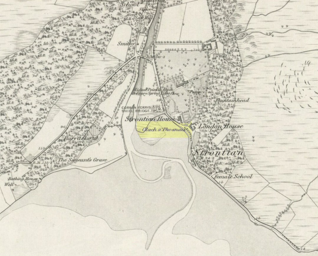
Clach a’ Phaonais on 1872 map

Shown on the first edition OS-map of the region in 1875, this old worn standing stone, more than six-feet tall, can be seen at the edge of the drive.  There’s an iron ring is attached to it, which I thought might have made it an old Bull Stone in bygone days, but no such lore is remembered.  Also known as the Branks Stone, it’s Gaelic name probably means the ‘stone of penance,’ and folk were chained to it in eaelier days for bad behaviour.  It was widespread across the Highlands to tie criminals to stones and wooden poles, naked, for 24 hours and let the midges get to them.  Crime was down to a minimum up here!

Folklore

As the locals at Strontian Hotel told me (thanks Finlay), “several stories have emerged locally. It marks a clan chief’s grave, a sighting stone for the equinox but the most plausible one is based on the fact that there is an iron ring on the side of the stone facing the loch and it was used to tie up barges taking lead from the local lead mine.  It supplied the raw material for shot during the Napoleonic and Crimean wars.”

Aknowledgements:  Big thanks to Anne and the Megalithic Portal for additional help on this one.

© Paul Bennett, The Northern Antiquarian


Brotton Howe, Brotton, Cleveland, North Yorkshire

Cairn (destroyed):  OS Grid Reference – NZ 6950 1886

Archaeology & History

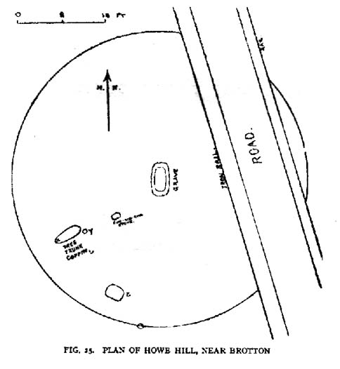
Frank Elgee’s 1930 plan

Another old site that has sadly succumbed to that bollox called ‘progress’! It’s in the North Yorkshire region some halfwits have taken to calling Cleveland — but which a lotta local folk still correctly call Yorkshire.  But that aside…

In an article by local students William Hornsby and Richard Stanton written in 1917, we find that this was just one of at least seven hillocks presumed to be barrows here — but all the others had gone even in their day.  When Crawford (1980) came to survey the site in the late 1970s, he told that,

“this large barrow is now only visible as a low swell in an arable field… (but) the profile of the barrow is retained in the hedgeline that bisects it from north to south, but the whole of its eastern half has been obliteratd by the Brotton-Kilton road.”

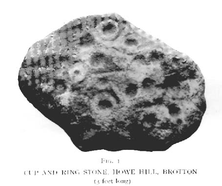
Elgee’s 1930 photo of one of the carvings
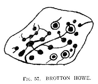
E.T. Cowling’s drawing of one of the carvings

When Hornsby and Stanton checked the place out it measured 54 feet in diameter and had an extensive covering of small stones, like a large cairn, with a single grave at the centre, aligned north-south; and a tree-trunk coffin on the southwestern side.  Of the stones which filled the central grave, eight of them were found to have cup-markings on them; whilst 16 stones covering the tree-trunk grave also possessed cup-markings. Roughly equidistant between the two burials was another stone found to be resting face-down on the original ground-level, and covered with 20 cups and 5 cup-and-rings!  Awesome stuff!

G.M. Crawford’s (1980) description of the site was as follows:

“Howe Hill was excavated by Hornsby and Stanton in 1914; they discovered that the mound was made up with a clay floor, overlain by ‘a cairn 30 feet long and 3 feet high’ of diorite cobbles, capped by a layer of earth. Cut into the clay floor were two graves: the first was oriented north-south and measured 2m long by 0.9m wide at the old land surface and was 0.7m deep. The grave was filled with ‘medium sized stones’ with a ‘thin dark layer,’ thought to be an inhumation burial, on the floor; 8 of the stones bore cup-marks. The second grave, oriented northeast-southwest, was 2.5m long by 0.9m wide at the old ground surface, reducing to 1.8m long by 0.5m wide at its bottom, 1.3m below. This grave, which was filled with stones, also contained a tree-trunk coffin or oak, measuring 1.5m long… At the head (northeast) were found the unburnt skull fragments of a man laid on its right side. Unaccompanied cremations had been placed at both ends of the coffin. 16 cup-marked stones were among the infill of the grave.”

This was obviously a site of considerable importance and it’s a huge pity (if not a disgrace) that today no trace of the site remains.

References:

  1. Cowling, Eric T., Rombald’s Way, William Walker: Otley 1946.
  2. Crawford, G.M., Bronze Age Burial Mounds in Cleveland, Cleveland County Council 1990.
  3. Elgee, Frank, Early Man in North-east Yorkshire, John Bellows: Gloucester 1930.
  4. Hornsby, William & Stanton, Richard, “British Barrows near Brotton,” in Yorkshire Archaeology Journal, 24, 1917.
  5. Smith, A.H., The Place-Names of the North Riding of Yorkshire, Cambridge University Press 1928.

© Paul Bennett, The Northern Antiquarian


Ardlamey, Gigha, Argyll

Cairn:  OS Grid Reference – NR 63091 48258

Also Known as:

  1. Canmore ID 38524

Archaeology & History

A decent-sized cairn, around 50 feet across (even though much of the stone has been nicked) and about 3 feet high, with a singular large cist near its centre. When the Scottish Royal Commission lads checked the place out in 1967, at least four of the kerb stones were still in situ (on its north, west and southwest sides) – the tallest being its northern stone, more than 6 feet high. The northern stone also had a peculiar deposit of white quartz and pebbles laid at the base, placed there quite deliberately – unlike the others which rested on a level of sand and gravel.

The Scottish Royal Commission (1971) also reported the former existence of two cists not far from here, “uncovered by the plough during the 19th century on the farm of Ardlamey”: one at NR 637 484, and the other at NR 635 484.

References:

  1. Royal Commission on the Ancient & Historical Monuments of Scotland, Argyll – Volume 1: Kintyre, Glasgow 1971.

© Paul Bennett, The Northern Antiquarian

Taynuilt, Lorn, Argyll

Standing Stone:  OS Grid Reference – NN 0120 3115

Also Known as:

  1. Canmore ID 23497

Archaeology & History

Nearly twenty years have passed by since I last saw this rather small standing stone – ‘small’ for Argyll that is!  It’s near the corner of a field half-a-mile east of Taynuilt village, about 300 yards off the main Oban road. The Scottish Royal Commission (1974) chaps describe it quire accurately, telling it to be,

“a granite boulder, roughly triangular in shape at the base, and measuring 0.75 metre by 0.60 metre by 0.55 metre at ground-level. It now stands to a height of 1.2 metres (nearly four-feet tall in normal language! – Ed), but pieces have been split off in comparatively recent times and it may originally have been taller.”

It’s about time I got my arse back up ambling and exploring around this part of Scotland.  Tis a gorgeous part of the world…

References:

  1. Royal Commission on the Ancient & Historical Monuments, Scotland, Argyll – volume 2, HMSO: Edinburgh 1974.

© Paul Bennett, The Northern Antiquarian

Llangynidr Bridge, Llangynidr, Breconshire

Standing Stone:  OS Grid Reference – SO 1562 2039

Also Known as:

  1. Gliffaes Stone
  2. Llywn y Fedwen

Getting Here

Not too difficult – and its size makes it pretty easy to spot!  About 100 yards across the river bridge from Llangynidr, there’s a small path heading into the trees by the riverside. Walk along it, or whichever way you find easiest to walk along the riverbank.  Then as you reach the third field along, look up into the hedgerow-cum-fence above you and you’ll notice the old stone sticking up!  Head for it!

Archaeology & History

A 14 foot tall standing stone with a most peculiar ‘modern’ history to it.  Some of you will like this, others may have palpitations – but… In recent times, since the notion of “energy at megaliths” have been in vogue, this was one of the first monoliths found to possess magnetic anomalies.  Described by the writer Francis Hitching (1976), he asked the Welsh dowser Bill Lewis to dowse at this stone and checked the results. Lewis dowsed a spiral of ‘energy’ rising up the stone as he did at many standing stones, and urged Hitching to see if he could bring his findings to the attention of any scientists.  So Hitching contacted the physicist professor John Taylor — he of Black Holes fame, of Kings College, London — who felt that Lewis’ dowsing finds were probably due to him sensing subtle changes in the magnetic field of the stone.  And so with this in mind, he sent a young Argentinian physicist called Eduardo Balanovski, armed with a gaussmeter, to see what they could find. As Hitching later wrote:

“What Balanovski found surprised him very much. After checking the background levels and setting the meter at zero, he pointed the measuring probe at the stone. The needle on the dial shot up, showing an anomaly far greater than the few thousandths or hundredths of a gauss that would have been normal…

“Balanovski has no doubt that the basic anomaly…is significant: ‘The point is that a water-diviner told us about it, and we went there and found something measurable. It may be the stone contains, geologically, the reason for the anomaly. Or it may be caused by something we don’t yet understand. But I do not personally believe that the stone was accidentally chosen or accidentally placed. The people who put it there knew about its power, even if they didn’t know about electromagnetism.'”

This initial finding brought Taylor himself to the place, where he, Balanovski and Lewis set to work.

“Lewis was filmed marking with chalk the places on the stone where he dowsed ‘energy nodes.’ When the gaussmeter probe was passed down the stone, it did register increases of magnetism at the marked points – there seemed to be ‘a very strong field on and around the stone, which seemed to fall in bands,’ as Hitching put it. It was a very impressive demonstration. Taylor urged caution, pointing out that much more work would need to be done to be sure of such reactions.”

Further work was eventually carried out by the Dragon Project, where no anomalous readings were found. Hmmm….

References:

  1. Devereux, Paul, Places of Power, Blandford: London 1990.
  2. Hitching, Francis, Earth Magic, Cassell: London 1976.

© Paul Bennett, The Northern Antiquarian

Askwith Moor (521), North Yorkshire

Cup-Marked Stone:  OS Grid Reference – SE 17162 50530

Also Known as:

  1. Round Rock

Getting Here

To find this, head for the line of old grouse-butts which run north-south, a few hundred yards west of the Askwith Moor Road. Just before y’ get to the one nearest the bottom of the line, frobble about a bit.  If by any chance you end up at the Woman Stone carving, walk back up the slope until you’re on the level.  Not far ahead of you are the upright stone remains of a grouse-butt.  This carving is just a few yards away.  You’ll find it.

Archaeology & History

Image © Richard Stroud

This was another carving found on one of the many forays of Mr Chappell and I when we were young, sometime in 1993.   A short while after, Graeme wrote to Edward Vickerman to inform him of the find, which ended up in their rock art survey a decade later.

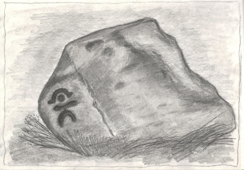
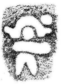
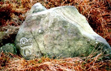
It’s another one of those simple designs: what seems like at least 5 cup-markings on a small rounded rock, with two of them linked together by a groove — possibly natural, possibly man-made — though there may in fact be seven or more cups etched onto its upper surface.  It’s difficult to tell.  It gives you the impression that its present position isn’t its original one and is suggested by Boughey & Vickerman (2003) to have been “moved from pipeline?” close by.  It may even have been dug out and cast here, possibly once being a part of a cairn.  In the Boughey & Vickerman survey they give its OS-coordinate as SE 17163 50527 – and describe it as a “medium-sized, free-standing rock of fine grit. Five cups, some perhaps natural.”  When Richard Stroud and I visited the site, he found the GPS coordinate was SE 17162 50530; and we have to say that instead of describing it as a free-standing rock, it’s a movable stone (though it’d take a bit of effort), that may once have been part of a larger monument.

References:

  1. Bennett, Paul & Chappell, Graeme, Personal Communication, 1993.
  2. Boughey, Keith & Vickerman, E.A., Prehistoric Rock Art of the West Riding, WYAS: Wakefield 2003.

© Paul Bennett, The Northern Antiquarian 

Burwains, Foulridge, Lancashire

Cairn (destroyed):  OS Grid Reference – SD 888 421

Archaeology & History

Burwains on the 1848 map

The place-name burwain is an early Old English word meaning “a cairn or tumulus”.  It has variants such as borrans, borwen and borwans.  In the developing survey by Parsons & Styles (2000), other linguistic examples are given, all of which point to the same thing, i.e., a prehistoric burial of one form or another.  Also, in 19th century northern English dialect, Wright (1898) told that borrans is “a cairn, a heap of loose stones”—which is what used to exist hereby.

The fact that there is a place-name telling of its existence implies that it was a cairn of some size, but sadly all remains of it have long since gone.  All that we’ve got left is the name of Burwains house on the early Ordnance Survey maps.  Built on a hilltop rise, which is a common construction spot for such sites up and down the country, it’s possible that the cairn was destroyed when the Foulridge Lower Reservoir was built in 1793, with the mass of stone used in its construction (the reservoir also kept the name of Burwains lake for sometime).

References:

  1. Clayton, John A., Valley of the Drawn Sword, Barrowford Press 2006.
  2. Parsons, D.N. & Styles, T., Vocabulary of English Place-Names – volume 2, EPNS: Nottingham 2000.
  3. Smith, A.H., English Place-Name Elements – volume 1, Cambridge University Press 1954.
  4. Wright, Joseph, English Dialect Dictionary – volume 1, Henry Frowde: London 1898.

© Paul BennettThe Northern Antiquarian

Standing Stone, Foulridge, Lancashire

Standing Stone:  OS grid reference – SD 8803 4316

Also Known as:

  1. Lark Hill Stone
Possible Standing Stone in walling close to Standing Stone Road crossroads
‘Standing Stone Road’ monolith

Getting Here

From Foulridge go west up the long windy road (B6251) till you hit the old crossroads near the top.  Turn right and go on till you hit the modernised farmhouse on your right, where you’ll notice a modern upright stone in the entrance.  You need to go back about 70 yards and you’ll see this old stone in the wall.

Archaeology & History

"Standing Stone Road' stone!
“Standing Stone Road’ stone!

Less than a mile northwest of Foulridge along the southern stretch of the Whitemoor Reservoir, on the northern outskirts of Colne, we find the intriguingly-named ‘Standing Stone Lane’ — which seems to indicate that at some time in the not-too-distant past, an old monolith could be found hereabouts.  The old maps show the boundary line turning at right angles just near the crossroads, which is where I thought we might locate some remains of an old standing stone.  But it wasn’t to be.  Instead, we need to travel about 100 yards west along the single-track road, just below the reservoir — and there, in the walling, plain for all to see, is what may be the old standing stone which gave the road its name.  I found this site in early July 2008, and although we can’t be 100% certain, it’s not too bad a good contender as the monolith which first gave the road its name.  Does anyone know anymore about it?

More probably though (and this is what ‘feels’ right): the original stone which gave the road its name was much bigger than this little thing, but was probably destroyed when the reservoir here was constructed.  How much d’ y’ wanna bet!?

© Paul Bennett, The Northern Antiquarian

Aston Cursus, Aston-on-Trent, Derbyshire

Cursus Monument:  OS Grid Reference – SK 417 285 to SK 424 296

Also Known as:

  1. Aston-upon-Trent Cursus

Archaeology & History

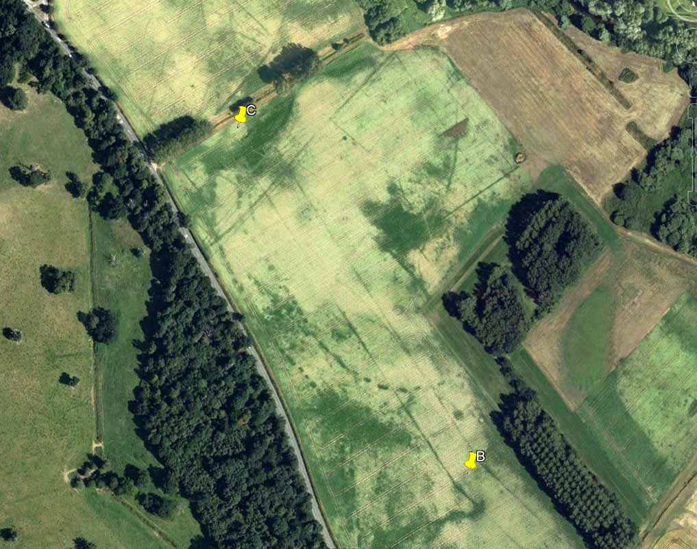
Aerial photo of the cursus (courtesy Antiquity journal)

Once to be seen running from the edges of Weston Grange northeast by the canal around Acrelane Bridge, this important mile-long neolithic monument beyond the southern outskirts of Derby has been damaged along much of its length due to the carefree approach of modern industrialists.  Found just over 6 miles east of the Potlock or Twyford Cursus, this site was described by J.K. St. Joseph (1964; 1966) in Antiquity journal following an aerial survey of the region on August 7, 1962 — from whence the photograph here was taken, which shows the dead straight monument stretching southwest across the fields.  The photo also gives a good idea as to how massive this prehistoric monument actually was!  In Mr St. Joseph’s second short essay on this aligned site he told:

Aston Cursus (from Antiquity, 1966)

“The cursus at Aston upon Trent lies at a distance of half a mile from the left bank of the Trent, on gravel overlying New Red Sandstone, at a height of about 120ft O.D., some five miles southeast of Derby.  No traces are visible on the surface, but photographs taken over the last few years enable the side-ditches of the cursus to be traced for a length of some 4500ft on a north-east to south-west alignment across six fields: the ditches are parallel and some 325ft apart.  Though the entire length has not yet been recorded, the south-west end must lie near the farm of Weston Grange, while the north-east end is a little to the east of the road from Aston upon Trent to Shardlow.  The north-western side ditch is interrupted towards the south-west end by two narrow gaps, 500ft apart.

“…Two ring-ditches lying within the cursus perhaps mark ploughed-out barrows.  In diameter they measure some 120ft; one of them is defined by a double ditch.  There are at least three small ring-ditches, of which one is intersected by the north-west ditch of the cursus.  Five small square enclosures lying within the cursus towards its north-east end are less easy to explain.  They are not unlike the square ditched enclosures recorded on the Yorkshire Wolds, and there identified as square barrows.   About halfway along the length of the cursus a single ditch encloses an irregular area interrupted at two points for an entrance.  One end of this area and the north-west ditch of the cursus overlap.  Thereabouts, too, the cursus is crossed by elements of a system of linear ditches, which seem to be agricultural divisions of a kind often interpreted in the Middle Thames valley as of Iron Age or Roman date.  A similar date is likely enough here, but the question is best left open until some examples have been tested by excavation.  Lastly, the “pit-alignment” which extends for some distance towards the (River) Trent is seen to cross the whole width of the cursus, as does a double-line of pits nearer the north-east end…”

More than forty years later and the site is described on English Heritage’s website – at www.pastscape.org.uk, where a few additional aspects of the site are described:

“A cursus monument at Aston Upon Trent, orientated roughly southwest-northeast and located on the gravels of the trent valley, circa 1 kilometre northwest of the present course of the river.   The cursus appears to be a regular rectangle, the long sides parallel and circa 100 metres apart. The southwest terminal is straight, and meets both sides at right angles. The northeast terminal has not been recorded as a cropmark, but may well have lain in an area which has been quarried away. If so, the cursus would have originally been a little over 1.5 kilometres in length.

“The cursus ditch was sectioned in the mid-1960s by D. Reaney, though no finds were made. The recorded stratigraphy suggested an internal bank.  Further small-scale excavation occurred in 1986 at a point where the cursus ditch appeared to intersect with a ring ditch (SK 42 NW 59), towards the cursus’ south-western end. The cursus ditch appeared to run into and cut the ring ditch, and was therefore later in date. The slightness of the ring ditch and the nature of its fill suggests that there is unlikely to have been a mound of any substantial nature in its interior. Finds were few, and none from primary contexts. They comprised a thumb nail scraper, another worked flint, and a few sherds of pottery, identifiable as Grimston and Beaker ware.

“Adjacent to the ring ditch is another, not excavated, but also contained within the cursus. In 1995, an existing field drain alongside Acre Lane (in the area circa SK 4244 2968) was enlarged as part of work associated with construction of the Derby Southern Bypass.

“The sides of the drain were recorded archaeologically. The western cursus ditch was not present, suggesting the existence of a gap or causeway. The eastern cursus ditch, though not visible on air photographs at this point, was located. Pollen samples were collected, and a fragment of waterlogged wood is to be used for radiocarbon dating.”

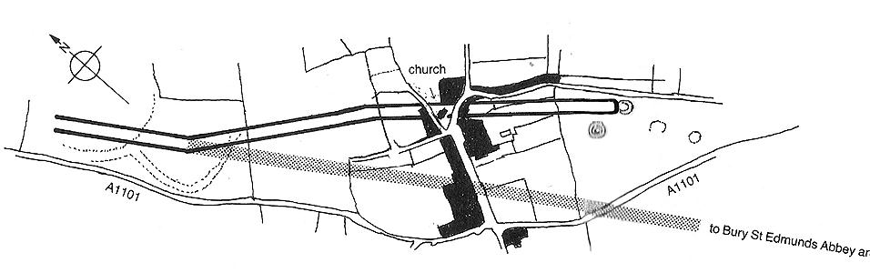
The site has since been found to be at least 1700 metres (5610 yards) long, with its northeastern end, or terminus, still undiscovered.   It was described by Loveday (2006) as being, “overlain at its mid-point by a tangle of fields and trackways of presumed Iron Age date.”  One prehistoric track crosses the cursus at a right-angle then turns 90° just as it crosses the dead straight alignment, running parallel with the cursus ditch for some 300 yards. (see illustration below)

References:

  1. Gibson, A.M. & Loveday, Roy, ‘Excavations at the Cursus Monument on Aston-upon-Trent, Derbyshire,’ in A.M. Gibson’s Midlands Prehistory, BAR 204: Oxford 1989.
  2. Loveday, Roy, Inscribed Across the Landscape, Tempus: Stroud 2006.
  3. St. Joseph, J.K., “Air Reconnaissance: Recent Results, 6,” in Antiquity, volume XL, no.157, March 1966.
Aston Cursus, with overlying Iron Age tracks & fields (after Loveday 2003)

© Paul Bennett, The Northern Antiquarian