Simple. The church in the centre of the village across from the T-junction with the A5 is where it’s at!
Archaeology & History
Cross-base with cup-marks (from Owen, 1886)
At Corwen churchyard we find a number of curious old stone relics — not least of which is this seemingly 12th century christian cross, more than seven-feet tall, on the west side of the church. Not only does this have a curious history in itself, but the base on which the cross stands has what may be at least seven cup-markings etched on it. These were first mentioned – I think – by Elias Owen in his Old Stone Crosses of the Vale of Clwyd, (1886) who wrote:
“The stone basement in which the (cross) shaft is placed is elliptical in form, with transverse and conjugate diameters measuring respectively 64 and 60 inches; it is 12 inches or so thick, is of a slaty nature and might have been procured in the neighbourhood… There are seven peculiar artificial depressions along the surface of the pedestal, strongly resembling the cup-markings which are found occasionally on the capstones of cromlechs, etc. They are irregularly arranged: on the north side there are three, almost in a line; and on other parts of the stone there are four of these marks. They differ somewhat from each other in size and shape, but they are for the most part circular, though one is more of an oblong than a circle. They vary also in depth, one being two-and-half inches deep, while the others are shallow. The largest is three inches in diameter; the others are not so broad.”
Owen makes note of a previous description of the Corwen “cross” by Thomas Pennant in 1784, where sounds as if this stone had a decidedly megalithic precursor. He told us:
“A most singular cross in the churchyard merits attention: the shaft is let into a flat stone, and that again is supported by four or five rude stones, as if the whole had been formed in imitation of, and in veneration of, the sacred Cromlech of very early times.”
Two other crosses are found at Corwen church – one of which has a decidely heathen legend attached to it. The Carreg y Big yn y Fach Rhewllyd monolith is also found here, in the porch wall. A few miles east of here we also find another cup-marked stone, shown on The Old-Fashioned Antiquarian website. Looks a good n’!
References:
Owen, Elias, Old Stone Crosses of the Vale of Clwyd and Neighbouring Parishes, Bernard Quaritch: London & Oswestry 1886.
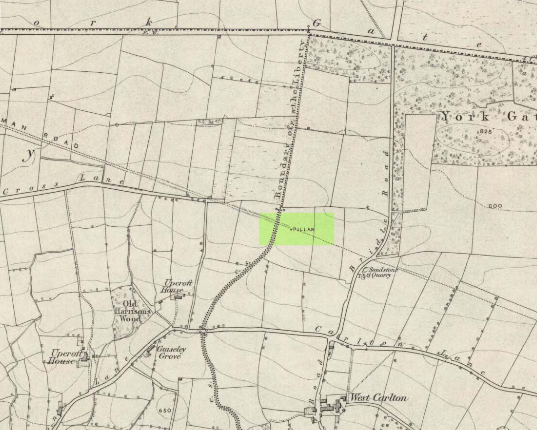
Worth checking this if you aint seen it before! Head up to the back (south-side) of Otley Chevin (where the cup-and-ring Knotties Stone lies sleeping), following the road there and park up near/at the Royalty pub. Take the footpath behind the pub which crosses the fields and once into the second field, head diagonally down to the far-left corner. From here, look over the wall — you can’t really miss it!
Archaeology & History
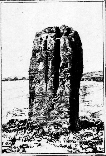
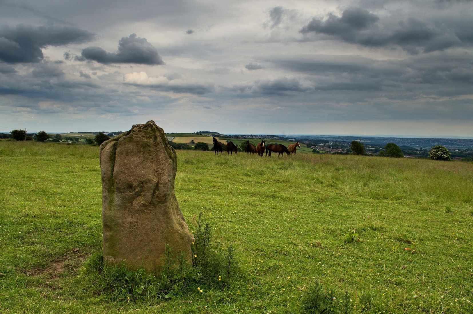
An intriguing site for various reasons. All we have left to see of any value nowadays is this nigh-on 6-foot tall thick monolith, standing alone in the field halfway between West Carlton and Otley Chevin. Completely missed in local archaeological surveys, the place was mentioned briefly by Slater (1880); though it appears to have been first described in detail by Eric Cowling (1946), who suspected the stone may have Roman origins (though didn’t seem too convinced!), saying that:
“near the ground the section is almost oblong, with sides three-feet six-inches by one-foot ten-inches; two feet from top, the section is almost circular.”
The fact that the stone stands very close to the line of an all-but forgotten Roman road that runs right past it added weight to this thought (the road runs towards a Roman settlement a mile east of here near Yeadon). But this standing stone is unlikely to be Roman. More recent evidence seems to indicate a relationship with a now-lost giant cairn about 100 yards to the south. The only remains we have of this place are scatterings of many small loose stones nearby. And it seems a very distinct possibility that the extra standing stones that were once hereby, stood in a line.
The very first reference I’ve found about this site also indicates that there was more than one stone here in the past! In 1720 this site was known as the ‘Boon Stones’; and the plural was still being used by the time the 1840 Tithe Awards called them the ‘Boul Stones.’ Initially it was thought that both words were plural for “bulls” — as A.H. Smith (1962) propounds in his otherwise superb survey — but this is questionable. (see Folklore)
Folklore
A piece of folklore that seems to have been described first by Philemon Slater (1880) relates to the pastime of bull-baiting here, that is –
“fastening bulls to it when they were baited by dogs, a custom…still known to the Carlton farmers” (North Yorkshire).
Cowling (1946) told that he heard the stone was said to be lucky as well as being a source of fertility. This ‘fertility’ motif may relate to the meaning of the stone’s early name, the Boon Stones. Both boon and boul are all-but obsolete northern dialect words. ‘Boul’ is interesting in its association with a prominent folklore character, as it was used as a contemptuous term “for an old man.” Now whether we can relate this boul to the notion of the ‘Old Man’ in British folklore, i.e., the devil, or satan — as with the lost standing stone of The Old Man of Snowden, north of Otley — is difficult to say.
More interestingly perhaps is the word ‘boon’, as it is an old dialect word for “a band of reapers, shearers, or turf-cutters.” This band of reapers ordinarily consisted of five or six people and would collect the harvest at old harvest times. And as the early description talks of Boon Stones, this plurality would make sense. One curious, though not unsurprising folklore relic relating to these boons was described at another megalithic site (now gone) by John Brand (1908), where in the parish of Mousewald in Dumfries,
“The inhabitants can now laugh at the superstition and credulity of their ancestors, who, it is said, could swallow down the absurd nonsense of ‘a boon of shearers,’ i.e., reapers being turned into large grey stones on account of their kemping, i.e., striving.”
Standing stones with the folklore of them being men or women turned to stone is common all over the world. If we accept the dialect word ‘boon’ as the first name of this old stone, there may once have been some harvest-time events occurred here long ago (and this is quite likely). Equally however, we must also take on the possibility that this Bull Stone has always been a loner and that its name came from the now obsolete Yorkshire word, a bull-steann, meaning a stone used for sharpening tools, or a whetstone.
Take your pick!
References:
Bennett, Paul, The Old Stones of Elmet, Capall Bann: Milverton 2001.
Brand, John, Observations on the Popular Antiquities of Great Britain – volume 2, George Bell: London 1908.
Cowling, Eric T., Rombald’s Way, William Walker: Otley 1946.
Jackson, Sidney, ‘The Bull Stone,’ in Cartwright Hall Archaeology Group Bulletin, 2:5, 1956.
Smith, A.H., English Place-Name Elements – 2 volumes, Cambridge University Press 1956.
Smith, A.H., The Place-Names of the West Riding of Yorkshire – volume 7, Cambridge University Press 1962.
Slater, Philemon, The History of the Ancient Parish of Guiseley, William Walker: Otley 1880.
Standing Stones (destroyed): Grid Reference – G 915 605
Archaeology & History
Field-notes collected by Oliver Davies described there being “two standing stones, side by side,” at the coordinate given here. In Lacy’s Archaeological Survey (1983), he told that the larger and southernmost of the monoliths stood 5’10” high, with its companion being just 3 feet tall. All remains of these stones have apparently vanished.
References:
Lacy, Brian, Archaeological Survey of County Donegal, DCC: Lifford 1983.
Long Barrow (destroyed): OS Grid Reference – SS 5848 9227
Also Known as:
Cae Bryn-y-garn
Archaeology & History
Described in 1925 in a report by the Royal Institute of South Wales as “the remains of a long barrow,” it seems that all remains of this old site have been destroyed. Where the long tomb once stood are now some bungalows (anyone know if they’re haunted!?).
The tomb was quite an impressive one from all accounts: aligning north-northeast, it was some 20 yards long and 10 yards wide (at its widest), standing between 6-8 feet tall. When building operations started here in 1959, a disturbed mound of stones was noticed, but by 1965 the bungalows had been built where once rested the ancient dead.
The field-name to its immediate east — Cae Bryn-y-garn — tells us the old name of the cairn, as known to local folk. Quite what its folklore may have been, I’ve yet to hear…
References:
Royal Commission on the Ancient & Historical Monuments, Wales, An Inventory of the Ancient Monuments in Glamorgan – Volume 1, HMSO: Cardiff 1976.
Dead easy. Take the road up through Grassington village, up Moor Lane, onto the grassy tops towards Yarnbury. As the road levels out, and before you reach the tree-border of Yarnbury house, there’s a field on your left-hand side, opposite the one where the Yarnbury Henge lives. If y’ go in there to check out this walling, shut the effing gate!
Archaeology & History
Section of walling, Yarnbury
It appears that there’s little information on the remains of what seems to be some Iron Age walling a few hundred yards away, northwest of the little Yarnbury ‘henge’ monument. Mikki Potts noticed it first of all, in one of the Northern Antiquarian ambles here t’other day. The walling is quite distinct and typical of finds elsewhere, particularly the excessive Iron Age and Bronze Age walling remains less than a mile west of here, down the slopes near Grasssington. At least two lines of walling are clearly apparent, running roughly northeast-southwest. Another section runs off towards the extant walling back towards the road. But more intriguing (for me anyway!), is what seems to be the remains of an old circle less than 100 yards north, on the other side of the footpath in the same field.
We didn’t spend too much time here and so another visit is obviously needed for further exploratory wanderings, but there appear to be further remains. Although much of the terrain hereabouts is scattered with an excess of medieval archaeological relics — including some disused shafts at the very top of this same field — this section of walling has all the hallmarks of a much earlier period. (sadly, a lot of the early mine-workings up here has destroyed a considerable amount our earlier prehistoric heritage). As one local told us a a coupla weeks back, “There’s loadsa stuff up here which aint in the record books!”
Certainly seems like it!
(In the event that these remains turn out to be of a later period, this profile entry will be removed from TNA.)
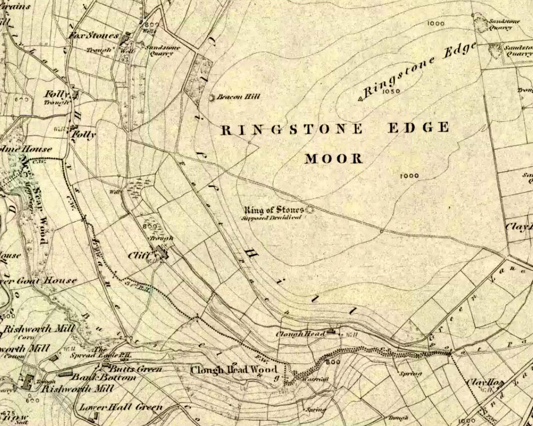
From Ripponden, taken the steep road up to Barkisland, but at the crossroads just before the village, turn right (south) and keep going for a mile till you reach the reservoir. At the far-end of the reservoir, take the track down by its side and follow the footpath that bends round the edge of the grasslands. Go up onto this small moorland and, once you’re on the level, head towards where you’ll see a large pile of stones a coupla hundred yards away. That’s it!
Archaeology & History
If we visit this site today, all we are left with is a scattered mass (or perhaps that should that be ‘mess’) of many hundreds of stones: the last remnants of what once would have been a proud circle of one form or another upon this small moorland plain. Its significance was such that the very moor on which its remains are scattered, was named after it: the Ringstone Edge Moor. But as with many sites from our megalithic period, this old place is but a shadow of its former self.
Gone are the upright monoliths which, tradition relates, once surrounded this low scattered circle of small loose stones (which would have made it look not unlike the wonderful stone circle of Temple Wood, Argyll). These standing stones were, so the folk record tells, removed near the end of the 18th century for use in some walling.
Described variously as a stone circle, ring cairn, cairn circle, an enclosure, and more, the site first seems to have been written about in 1775 by the great historian John Watson. When he was vicar of the local parish in Halifax (not far from here) this “ring of stones” as he called them, was “called the Wolf-fold.” Nearly one hundred years later, in F.A. Leyland’s superb commentary to Watson’s work, he wrote,
“The stones which constituted the circle at the time of their removal stood upwards of three feet…and the remain formed a striking object on the moor. The original number of stones of which the circle was formed is unknown, having long been in ruin and reduced in quantity before being finally removed. This was effected about twelve years since by the present tenant of the dam.” – that is, around 1859.
However, when Crabtree (1836) described the circle a decade or two earlier, he made no mention of such standing stones — although we must consider that Crabtree was very much like many modern academic archaeologists who tended to copy the works of others, much less than getting out in the field to see for himself.
At the beginning of the 20th century, the lore telling of the standing stones’ demise was repeated by local historian John Priestley (1903), when he said that: “all the large stones…were carted away about forty years ago” — that is, around 1863.
So it would seem that the very final destruction of the standing stones here, occurred sometime during the four year gap which Messrs. Leyland and Priestley describe.
More than fifty years later, Huddersfield historian James Petch (1924) came here to explore whatever remains he could find, and told:
“On top of a flat plateau on this moor, with an extensive view on all sides save on the north, where there is a gentle slope for some hundreds of yards up to the summit of the hill, there are distinct traces of a circular ring of small stones. Pygmie flints have been picked up within a yard or two, but the only other fact to be noted about this earthwork is that there is a tradition to the effect that much earth has been removed from this site. It is not altogether impossible that this is a scanty remnant of a round barrow.”
This latter remark of Mr Petch seems most probable. The excessive scatter of small stones typifies the remains of many of the Pennine giant cairns, from the Little Skirtful on Burley Moor and giant tombs of the Black Hills near Skipton, to the similar monuments of our Devil’s Apronful, Pendle, etc, etc.
Close to this cairn circle, wrote Sidney Jackson (1968), there used to be the remains of an Iron Age settlement, “marked by wall foundations (but) is now covered by the waters of Ringstone Reservoir.”
Folklore
There is very little folklore that I’ve found here. Watson (1775) throws the usual idea that the place was a site of druidical worship; but other than that we only have a local Ripponden writer’s account, which told that there was once the ghost of a white lady that was once said to walk along the path somewhere between here and the Beacon Hill tumulus, a short distance to the north.
Attributed by Michael Dames (1996) and others before him as the abode of the Dagda and the house of the sun, this huge monument was recorded in the Irish Annals as being destroyed in 1101 AD following a great battle. A site of mythic importance to the very early Irish Kings and Queens, and used by the shamans of the tribes, The Grianan is a place of of legendary importance to folklorists, historians and archaeologists alike and has been widely described over the last 150 years. Although the site you see today was hugely reconstructed between the years 1874 and 1878, it’s still impressive and, wrote George Petrie (1840), commands,
“one of the most extensive and beautifully varied panoramic prospects to be found in Ireland”!
Used over very long periods of time, the archaeologist Brian Lacy (1983) described the Grianan, on the whole, as,
“a restored ‘cashel’*, centrally placed within a series of three enclosing earthen banks; the site of an approaching ‘ancient road’; and a holy well.”
Early ground-plan of the Grianon
Lacy’s description in the Donegal Inventory is considerable and culls from the various surveys and reports done in the past. First surveyed by George Petrie in 1835, the internal body of the stone-built site is roughly circular and measures around 25 yards across, with a singular entrance on its eastern (sunrise) side. A stone ‘seat’ is at the end of the internal passage. At the centre of the huge ‘room’, Petrie recorded traces of a rectangular stone structure that he thought might have been the remnants of some old chapel built sometime in the 18th century.
More than 25 yards outside of the primary stone building is another surrounding embankment, oval in shape, low to the ground and with another singular entrance to the east — though this entrance is not in line with that of the main structure. At a further distance out from this embankment are the remains of another two oval ‘enclosures’, though the the remains of the outermost one is considerably more fragmented.
Although the replenished ‘fort’ dates from the Iron Age, early remains here are thought to have been of Bronze Age origin. A ‘tumulus’, now gone, being one such find here.
Folklore
There is much legend here. The creation myth narrated by Scott (1938) tells that it was,
“built originally by the Daghda, the celebrated king of the Tuatha de Danann, who planned and fought the battle of the second or northern Magh Tuireadh against the Formorians. The fort was erected around the grave of his son Aeah (or Hugh) who had been killed through jealousy by Corgenn, a Connacht chieftain.”
From similar legendary sources, it is told that,
“the time to which the first building of Aileach may be referred, according to the chronology of the Four Masters, would be about seventeen hundred years before the christian era. There are strong grounds for believing that the Grianan as a ‘royal’ seat was known to Ptolemy, the Greek geographer, who wrote in AD 120. In his map of Ireland he marks a place, Regia…which corresponds fairly well with its situation.”
By the outer banking on the south-side of the fortress is the remains of a much-denuded spring of water, the old water supply for this place. It gained the reputation of being a holy well, dedicated to St. Patrick.
References:
Dames, Michael, Mythic Ireland, Thames & Hudson: London 1996.
Harbison, Peter, Guide to the National Monuments in the Republic of Ireland, Gill & MacMillan: Dublin 1982.
Lacy, Brian, Archaeological Survey of County Donegal, DCC: Lifford 1983.
Petrie, George, ‘The Castle of Donegal,’ in Irish Penny Journal, 1, 1840.
Scott, Samuel, ‘Grianan of Aileach,’ in H.P. Swan’s Book of Inishowen, Buncrana 1938.
Swan, Harry Percival, The Book of Inishowen, William Doherty: Buncrana 1938.
From the Askwith Moor dusty parking spot, walk up the road for 160 yards where, on each side of the road, you’ll see a straight line running across the moors. On the left-side (west) walk onto the moor for 50-60 yards along this line, then dead straight west into the heather for another 50-60 yards and look around. It’s hard to see if the heather’s grown.
Archaeology & History
Found by Richard Stroud on July 20, 2004, this single hut circle is in faint evidence. About twenty feet across with a section of the low walling either missing, or more probably buried in the peat. Although no other hut-circles were immediately visible, this was probably because of the excessive heather-growth. I have little doubt that others will be close to this one, as the area is littered with prehistoric sites. The petroglyph catalogued as Askwith Moor 529 is very close to this hut circle.
The great Huddersfield historian, Philip Ahier (1948), in describing the lack of documentary evidence for several crosses in the neighbouring region, “at Deighton, Cowcliffe, Marsh and Golcar,” found out that,
“One did exist at Slaithwaite in front of the Manor House in the early past of the last century. In March 1931, the base of this cross, commonly known as the Dial Stone, was removed to Doughlas in the Isle of Man, where it rested in the garden of Mr Harry Wood; in August 1939, it was brought back to Slaithwaite and now stands in the Recreation Park.”
However, this site differs from another two that I’ve found records for on the outskirts of this township. Does anyone know what became of this old stone cross? Izzit still about? Its folk-name of the Dial Stone may make it a little easier to locate — but at the same time it does bring up the query, Why was it called that?
References:
Ahier, Philip, The Story of the Three Parish Churches of St. Peter the Apostle, Huddersfield – volume 1, Advertiser Press: Huddersfield 1948.
Long Barrow (destroyed): OS Grid Reference – SO 169 357
Also Known as:
Croesllechau
Archaeology & History
It appears to have been Theophilus Jones who first mentioned this all-but-lost megalithic tomb, more than 200 years ago. He told that,
“In a field called Croeslechau about two miles eastward of (Talgarth), but in the parish of Bronllys and on a farm called Bryn-y-groes, is a cromlech, not merely interesting on account of its antiquity, but from the circumstance of a white thorn growing close, and indeed under part of it, which has gradually raised the horizontal or covering-stone several inches out of its original position; it is therefore not only venerable as a relic of very ancient days, but as a natural curiosity.”
Croesllechau tomb in 1809
Thankfully he gave us the fine old drawing of the tomb, here reproduced.
Although shown on an 1832 map of the region, when Crawford (1925) came to describe this old tomb it had already been destroyed. He told that,
“the site is unknown and all memory of it is has completely vanished in the neighbourhood. Mr Evan Morgan had visited the site and reports that no traces of the ‘cromlech’ were visible; nor were enquiries of the farmer at Bradwys any more successful in identifying the site. It is not unlikely that the monument was destroyed when a new road was made…”
References:
Crawford, O.G.S., The Long Barrows of the Cotswolds, John Bellows: Gloucester 1925.
Jones, Theophilus, History of the County of Brecknock, volume 2, George North: London 1809.
")