This is one of at least fourteen petroglyphs in this parish that have been either lost or destroyed since their initial description in the 19th century. It was described in George Kinihan’s (1884) survey as a “flat irregular stone, sloping slightly towards the east: the cups are seven in number”, in a design similar to that of the constellation of Cassiopeia. When the Archaeological Survey of Ireland looked for the carving in 1990 it could not be located. Corlett (2014) suggests that a collection of rocks in a hollow to the north may conceal this and some of the other carvings in this cluster.
References:
Corlett, Christiaan, Inscribing the Landscape: The Rock Art of South Leinster, Wordwell: Dublin 2014.
Kinihan, George H., “Proceedings: Cup-marked and Inscribed Stones in the Counties of Wicklow and Wexford”, in Journal Royal Society Antiquaries Ireland, (4th series) volume 6, 1884.
Cup-Marked Stone (lost): OS Grid Reference – SG 21584 42271
Also Known as:
Ballykean ‘Stone K’ (Kinihan 1884)
Archaeology & History
This is one of at least fourteen petroglyphs in this parish that have been either lost or destroyed since their initial description in the 19th century. It was described in George Kinihan’s (1884) survey as being, “a small peaked stone, having on the western side two small cups.” The carving has not been seen since then and he seems to have made no sketches of the stone. When the Archaeological Survey of Ireland looked for the carving in 1990 it could not be located.
References:
Corlett, Christiaan, Inscribing the Landscape: The Rock Art of South Leinster, Wordwell: Dublin 2014.
Kinihan, George H., “Proceedings: Cup-marked and Inscribed Stones in the Counties of Wicklow and Wexford”, in Journal Royal Society Antiquaries Ireland, (4th series) volume 6, 1884.
Cup-Marked Stone (lost): OS Grid Reference – SG 21537 42375
Also Known as:
Ballykean ‘Stone F’ (Kinihan 1884)
Archaeology & History
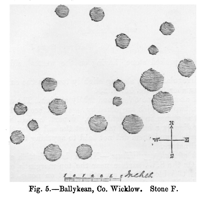
Kinihan’s 1884 rubbing of the stone
This is one of at least fourteen petroglyphs in this parish that have been either lost or destroyed since their initial description in the 19th century. It was described in George Kinihan’s (1884) survey as being, “a slightly dome-shaped stone, its surface being nearly level with that of the ground. The cups are both numerous and deep…although bits of the surface have been flaked off by fire.” He took a rubbing of the stone which showed nineteen cup-marks on its upper surface. When the Archaeological Survey of Ireland looked for the carving in 1990 it could not be located; and when Christiaan Corlett (2014) described this and the other carvings in this cluster, he thought that a group of stones dumped “in a hollow area north of the field” might possibly be where it had been moved to—although no such carvings have been identified there.
References:
Corlett, Christiaan, Inscribing the Landscape: The Rock Art of South Leinster, Wordwell: Dublin 2014.
Kinihan, George H., “Proceedings: Cup-marked and Inscribed Stones in the Counties of Wicklow and Wexford”, in Journal Royal Society Antiquaries Ireland, (4th series) volume 6, 1884.
Cup-Marked Stone (lost): OS Grid Reference – SG 21640 43035
Also Known as:
Ballykean Stone A (Kinihan 1884)
Archaeology & History
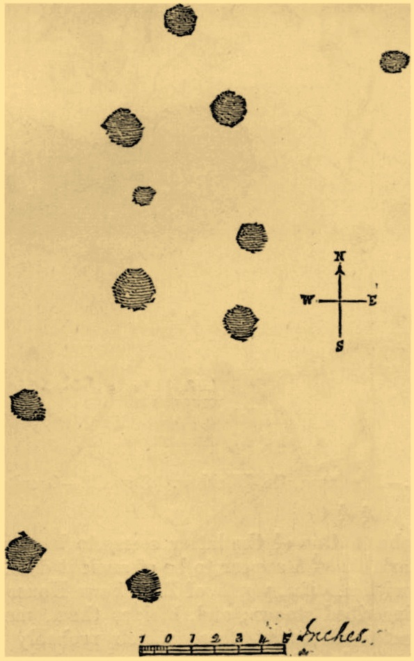
Kinihan’s rubbing of the stone
This is one of at least fourteen petroglyphs in this parish that have been either lost or destroyed since their initial description in the 19th century. First noticed by a Mr Hugh Jones of Ballykean House, it was the northernmost carving in the cluster. When the Archaeological Survey of Ireland looked for the carving in 1990 it could not be located—although they did note a stone of similar size in the field boundary to the north-east, but could find no cup-marks on it.
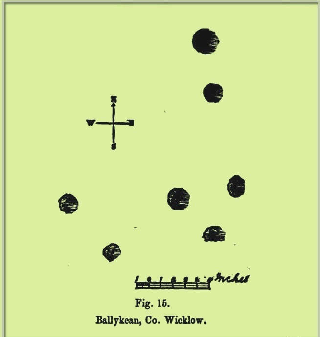
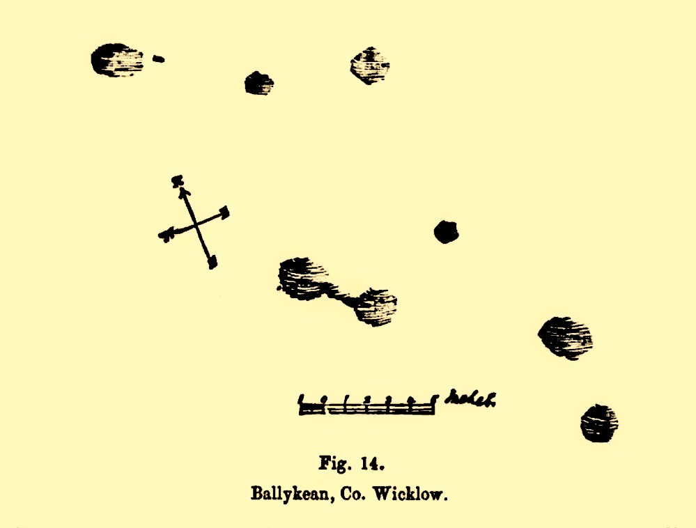
Ballykean (14 ) stone
When George Kinihan (1884) described the stone, he told it to be a block of granite, “about 5 feet by 5.3 feet, and standing 3.3 feet high” in a field known as the Fort Field (although there are no remains of a fort here). Kinihan took a rubbing of the carving, which highlighted eleven cup-marks on its upper surface, as illustrated here. More recently, in Corlett’s (2014) rock art survey, he told that there were “several large dumps of granite boulders” north of the field and wondered whether these might be where this, and the other stones, had been moved. Does anyone know…?
References:
Corlett, Christiaan, Inscribing the Landscape: The Rock Art of South Leinster, Wordwell: Dublin 2014.
Kinihan, George H., “Proceedings: Cup-marked and Inscribed Stones in the Counties of Wicklow and Wexford”, in Journal Royal Society Antiquaries Ireland, (4th series) volume 6, 1884.
Cup-Marked Stone (lost): OS Grid Reference – SG 21584 42230
Also Known as:
Ballykean ‘Stone M’ (Kinihan 1884)
Archaeology & History
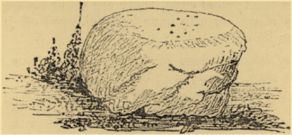
Ballykean (2) or “Stone M”
This is one of at least fourteen petroglyphs in this parish that have been either lost or destroyed since their initial description in the 19th century. When the Archaeological Survey of Ireland looked for this carving in 1990, it could not be located. It was first described by George Kinihan (1884), who told that it was, a “block about 6 by 5.5 feet, and 2.25 feet high. The upper surface has eight cups, two of which are joined by a channel.” The site was included in Corlett’s (2014) fine survey, who could add no additional data about the stone.
References:
Corlett, Christiaan, Inscribing the Landscape: The Rock Art of South Leinster, Wordwell: Dublin 2014.
Kinihan, George H., “Proceedings: Cup-marked and Inscribed Stones in the Counties of Wicklow and Wexford”, in Journal Royal Society Antiquaries Ireland, (4th series) volume 6, 1884.
Cup-Marked Stone (lost): OS Grid Reference – SG 21648 42072
Also Known as:
Ballykean ‘Stone N’ (Kinihan 1884)
Archaeology & History
This is one of at least fourteen petroglyphs in this parish that have been either lost or destroyed since their initial description in the 19th century. The carving was, wrote Kinahan (1884) in his day, “in the field south of Ballykean House.” But when the Archaeological Survey of Ireland looked for the stone in 1990, it could not be located. Kinihan told that it was,
“a large flattish stone, which slopes SW. On the SW surface near the top margin is one cup. In the vicinity of this block there are others, but on none of them were cups remarked. Most of these have been split, while others are said to have been broken up to build Ballykean House, with the farm buildings and walls.”
References:
Kinihan, George H., “Proceedings: Cup-marked and Inscribed Stones in the Counties of Wicklow and Wexford”, in Journal Royal Society Antiquaries Ireland, (4th series) volume 6, 1884.
The earliest OS-map of this area shows this well a hundred yards or so northwest of an old church and just a few yards east of the stream that is now in woodland; but unlike today, when the early survey was done there were no trees, enabling a clear view of the waters. When Myles Ronan (1927) wrote of the place, he told that it was still visible. The site was added to the Grogan & Kilfeather (1997) county inventory where they suggested it’s probable relationship with the legendary St Brigid. This seems highly probable. Does anyone know if the Well is still there?
References:
Grogan, Eion & Kilfeather, Annaba, Archaeological Inventory of County Wicklow, Stationery Office: Dublin 1997.
Ronan, Myles V., “The Ancient Churches of the Deanery of Arklow”, in Journal Royal Society Antiquaries, Ireland, December 1927.
Stone Circle (destroyed): OS Grid Reference – N 96998 14582
Archaeology & History
This stone circle was found close to the roadside and is remembered today only by the street-name of ‘Pipers Stones’. Shown on the first OS-map of the area, the site was destroyed sometime before 1838.
Folklore
In a folklore motif found at a number of megalithic rings, Grogan & Kilfeather (1997) tell us that the name of this circle,
“refers to a tradition that people caught dancing on a Sunday were turned to stone.”
References:
Grogan, Eion & Kilfeather, Annaba, Archaeological Inventory of County Wicklow, Stationery Office: Dublin 1997.
o’ Flanagan, Michael, Letters Containing Information Relative to the Antiquities of the County of Wicklow, Bray 1928.
Holy Well (destroyed): OS Grid Reference – T 2481 8173
Archaeology & History
Highlighted on the 1838 OS-map, Grogan and Kilfeather (1997) report that there are “no visible remains” to be seen of this holy well. The cult of St Patrick is still celebrated in Ireland every year on 17 March.
References:
Grogan, Eion & Kilfeather, Annaba, Archaeological Inventory of County Wicklow, Stationery Office: Dublin 1997.
Lynch, Geraldine, “The Holy Wells of County Wicklow,” in Wicklow History and Society (edited by K. Hannigan & W. Noland), Dublin 1994.
Attributed by Michael Dames (1996) and others before him as the abode of the Dagda and the house of the sun, this huge monument was recorded in the Irish Annals as being destroyed in 1101 AD following a great battle. A site of mythic importance to the very early Irish Kings and Queens, and used by the shamans of the tribes, The Grianan is a place of of legendary importance to folklorists, historians and archaeologists alike and has been widely described over the last 150 years. Although the site you see today was hugely reconstructed between the years 1874 and 1878, it’s still impressive and, wrote George Petrie (1840), commands,
“one of the most extensive and beautifully varied panoramic prospects to be found in Ireland”!
Used over very long periods of time, the archaeologist Brian Lacy (1983) described the Grianan, on the whole, as,
“a restored ‘cashel’*, centrally placed within a series of three enclosing earthen banks; the site of an approaching ‘ancient road’; and a holy well.”
Early ground-plan of the Grianon
Lacy’s description in the Donegal Inventory is considerable and culls from the various surveys and reports done in the past. First surveyed by George Petrie in 1835, the internal body of the stone-built site is roughly circular and measures around 25 yards across, with a singular entrance on its eastern (sunrise) side. A stone ‘seat’ is at the end of the internal passage. At the centre of the huge ‘room’, Petrie recorded traces of a rectangular stone structure that he thought might have been the remnants of some old chapel built sometime in the 18th century.
More than 25 yards outside of the primary stone building is another surrounding embankment, oval in shape, low to the ground and with another singular entrance to the east — though this entrance is not in line with that of the main structure. At a further distance out from this embankment are the remains of another two oval ‘enclosures’, though the the remains of the outermost one is considerably more fragmented.
Although the replenished ‘fort’ dates from the Iron Age, early remains here are thought to have been of Bronze Age origin. A ‘tumulus’, now gone, being one such find here.
Folklore
There is much legend here. The creation myth narrated by Scott (1938) tells that it was,
“built originally by the Daghda, the celebrated king of the Tuatha de Danann, who planned and fought the battle of the second or northern Magh Tuireadh against the Formorians. The fort was erected around the grave of his son Aeah (or Hugh) who had been killed through jealousy by Corgenn, a Connacht chieftain.”
From similar legendary sources, it is told that,
“the time to which the first building of Aileach may be referred, according to the chronology of the Four Masters, would be about seventeen hundred years before the christian era. There are strong grounds for believing that the Grianan as a ‘royal’ seat was known to Ptolemy, the Greek geographer, who wrote in AD 120. In his map of Ireland he marks a place, Regia…which corresponds fairly well with its situation.”
By the outer banking on the south-side of the fortress is the remains of a much-denuded spring of water, the old water supply for this place. It gained the reputation of being a holy well, dedicated to St. Patrick.
References:
Dames, Michael, Mythic Ireland, Thames & Hudson: London 1996.
Harbison, Peter, Guide to the National Monuments in the Republic of Ireland, Gill & MacMillan: Dublin 1982.
Lacy, Brian, Archaeological Survey of County Donegal, DCC: Lifford 1983.
Petrie, George, ‘The Castle of Donegal,’ in Irish Penny Journal, 1, 1840.
Scott, Samuel, ‘Grianan of Aileach,’ in H.P. Swan’s Book of Inishowen, Buncrana 1938.
Swan, Harry Percival, The Book of Inishowen, William Doherty: Buncrana 1938.