Croes-llechau, Bronllys, Breconshire

Long Barrow (destroyed):  OS Grid Reference – SO 169 357

Also Known as:

  1. Croesllechau

Archaeology & History

It appears to have been Theophilus Jones who first mentioned this all-but-lost megalithic tomb, more than 200 years ago.  He told that,

“In a field called Croeslechau about two miles eastward of (Talgarth), but in the parish of Bronllys and on a farm called Bryn-y-groes, is a cromlech, not merely interesting on account of its antiquity, but from the circumstance of a white thorn growing close, and indeed under part of it, which has gradually raised the horizontal or covering-stone several inches out of its original position; it is therefore not only venerable as a relic of very ancient days, but as a natural curiosity.”
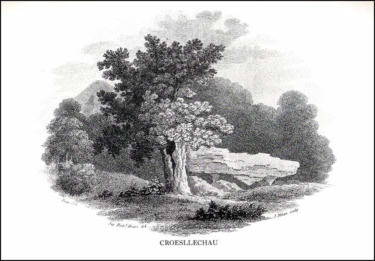
Croesllechau tomb in 1809

Thankfully he gave us the fine old drawing of the tomb, here reproduced.

Although shown on an 1832 map of the region, when Crawford (1925) came to describe this old tomb it had already been destroyed.  He told that,

“the site is unknown and all memory of it is has completely vanished in the neighbourhood. Mr Evan Morgan had visited the site and reports that no traces of the ‘cromlech’ were visible; nor were enquiries of the farmer at Bradwys any more successful in identifying the site.  It is not unlikely that the monument was destroyed when a new road was made…”

References:

  1. Crawford, O.G.S., The Long Barrows of the Cotswolds, John Bellows: Gloucester 1925.
  2. Jones, Theophilus, History of the County of Brecknock, volume 2, George North: London 1809.

© Paul Bennett, The Northern Antiquarian


Spread Eagle Cursus, Aberllynfi, Breconshire

Cursus Monument:  OS Grid Reference – SO 162 376

Archaeology & History

It seems that very little remains of this site, and there is some doubt over its authenticity.  Described in Alex Gibson’s (1999b) essay on the cursus monuments of Wales, he said this ‘cursus’ consists of,

“A cropmark of two parallel ditches orientated SE-NW, 15m apart and traceable for some 130m. It runs perpendicular to the present course of the River Wye 50m to the NE.  No terminals are visible, but there is a large ring ditch across the river 450m to the NW. A closely-grouped cluster of some 8 ring ditches is visible on a gravel terrace some 150m to the E,” but adds finally that “the identification of this site is suspect and may represent a fossil field system.”

The likelihood of the site being genuine seems to come from the “cluster of eight ring ditches on the gravel terrace some 150m to the east.”  Gibson (1999) also thinks how “the parallel ditches seem to be aligned on a ninth large ring-ditch 450m to the northwest and across the river.”  Ley-hunters have been scorned by archaeo’s for making such confounded comments!   The presence of a long cairn south of the cursus was also thought to add weight to the sites veracity.

Does anyone know what the present position on this site happens to be?

References:

  1. Gibson, Alex, The Walton Basin Project, CBA: York 1999.
  2. Gibson, Alex, ‘Cursus Monuments and Possible Cursus Monuments in Wales,’ in Barclay & Harding’s Pathways and Ceremonies, Oxbow: Oxford 1999b.

© Paul Bennett, The Northern Antiquarian