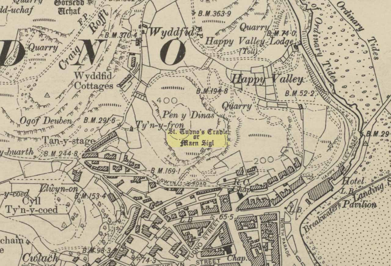
Highlighted on the 1901 OS-map of the area, this old rocking stone was located on the heights of Pen y Filas above Llandudno. Originally a site of heathen worship—the druids, it is said—the site was later patronised by the Irish saint, Tudno: a hermit who lived in a cave (Ogof Llech) a mile to the northwest, on the heights of the legend-filled Great Orme.
Rocking stones are well-known as geo-oracular forms (stone oracles) in folklore texts across the country, although they’re almost entirely rejected by historians as little more than ‘curiousities’ and meaningless geological formations. In olde cultures elsewhere in the world however, stones like this were always held in reverence by traditional people – much as they would have done in Wales and elsewhere in Britain.
References:
Hughes, Arthur R., The Great Orme: Its History and Traditions, R.E. Jones: Conway n.d. (c. 1950)
Jones, H. Clayton, “Welsh Place-Names in Llandudno and District” in Mountain Skylines and Place-Names in Llandudno and District, Modern Etchings: Llandudno n.d. (c.1950)
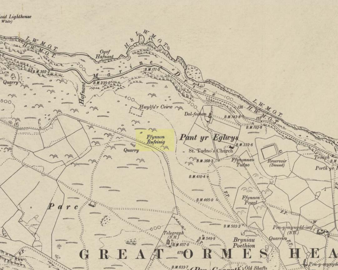
To be found on the legend-filled landscape known as the ‘Great Orme’, this ancient well was highlighted on the 1901 OS-map of the region, on the south side of the track. Sadly, despite an occasional puddle that fills the old trough when She rains, its waters are no longer running. H.C. Jones (n.d.) informed us that this was a ‘Roman Well’, which tradition said was a place they used when they invaded this part of Wales, although Paul Davies (2003) thought this “to be wishful thinking”.
Despite this, in recent years the walling around the well has been rebuilt by the track-side and a stone plaque with the words ‘Roman Well’ has been mounted to tell you that you’re at the right place.
References:
Davies, Paul, Sacred Springs, Blorenge: Llanfoist 2003.
Jones, H. Clayton, “Welsh Place-Names in Llandudno and District” in Mountain Skylines and Place-Names in Llandudno and District, Modern Etchings: Llandudno n.d. (c.1950)
An excellent passage grave tomb that’s been described by many historians over the last two hundred years, and was subject to a fine excavation in the first half of the 20th century. Ascribed as neolithic in origin, recent finds of human activity on the edge of the surrounding henge indicates people have been “up to things” hereby since at least 6000 BC. Deriving its name from “the mound of the black grove,” the site as we see it today has been much restored and is so different to when it was visited by Thomas Pennant and other antiquarians.
According to an anonymously written essay in Archaeologia Cambrensis in 1847, the site was first described by Henry Rowlands (1723) where, in relation to another site, he told were,
“the remains of two carnedds, within a few paces of one another: the one is somewhat broken and pitted into on one side, where the stones had been carried away; the other having had its stones almost all taken away into walls and hedges, with two standing columns erected between them.”
A somewhat more detailed description came from Thomas Pennant a few years later. He wrote:
“A few years ago, beneath a carnedd similar to that at Tregarnedd, was discovered, on a farm called Bryn-celli-ddu…a passage three feet wide, four feet two or three inches high and about nineteen feet and a half long, which led into a room about three feet in diameter and seven in height. The form was an irregular hexagon, and the sides composed of six rude slabs, one of which measured in its diagonal eight feet nine inches. In the middle was an artless pillar of stone, four feet eight inches in circumference. This supports the roof, which consists of one great stone near ten feet in diameter. Along the sides of the room was, if I may be allowed the expression, a stone bench, on which were found human bones, which fell to dust almost at a touch: it is probable that the bodies were placed on the bench… The diameter of the incumbent carnedd is from ninety to a hundred feet.”
Ground-plan
But the main excavation work at Bryn Celli Ddu was done in the late-1920s by W.J. Hemp (1930) and his team, who, as usual following such digs, ended up with just as many questions about the site as they had answers! One of the best descriptions of Hemp’s excavation work was by W.F. Grimes (1932) in an essay he wrote for the East Anglian Prehistoric Society where he gave the following detailed description of the finds:
“The cairn here was circular, with a chamber of some 160ft and an original maximum height of at least 12ft. The chamber is a polygonal structure of large stones augmented…with dry-stone walling, entered on the northeast side by a long passage built in the same way. Many of the stones had been dressed and in the chamber stood a single pillar which had been artificially rounded and smoothed, but which had never actually supported the capstone.
“These features had been more or less apparent for many years. But the reparation work soon showed that this was by no means all. In the first place, it was found that the chamber had been surrounded by four circles of standing stones. The first of these, around the outside of the mound at its base, had disappeared, although early accounts and a single hole found in the course of the work of excavation, are evidence of its existence. The second and third circles were found when the entrance to the passage wall was being cleared. Here the walls of the passage were found to merge into an outer circle of large stones and an inner of smaller, set close together and elaborately packed and sunk in a ditch six feet deep and eighteen wide, enclosing the chamber in such a way that passage, chamber and circles together form a gigantic unbroken spiral, with the chamber itself as an unbroken loop in it. The fourth and innermost circle was in the area enclosed by the ditch (which is represented on the plan by the shaded portion). This consisted of a number of stones of various sizes, irregularly placed and in some cases inclined outwards. Under some of them were deposits of burnt human bones. Lines connecting these stones diametrically were found to intersect at the centre of the monument, directly behind the chamber, and here was found a slab-covered pit which contained an elaborate filling whose purpose is unexplained. Beside the cover-stone of the pit was a second larger slab of grit, lying flat, the faces of which were covered with an elaborate and continuous pattern of spirals, scrolls and zig-zags. The position of this stone is shown beside the central stone on the plan. Of it purpose it can only be said that it was probably magical…
“As if the elaborate features already described thus badly were not enough, a uniform floor of purple clay was found to cover the old natural surface within the area enclosed by the ditch, and there were on the floor, in the ditch, and in many other places extensive traces of fire in the form of burnt patches, blackening and quantities of charcoal. In addition there were outside the entrance, a line of post-holes and remains of walls suggesting the former existence of some kind of forecourt crossed by a temporary barrier. Here also were traces of fire and of elaborate ritual. It must be emphasized of course, that all these features, with the exception of the outer circle of stones and the forecourt, had been completely concealed by the mound, so that they were not visible once the monument was completed… Moreover…the entrance to the chamber had been closed with an elaborate blocking which suggested that once closed the chamber had not been intended to be re-opened.”
Although many questions emerged following the excavation, perhaps that relating to the chronology and evolution of the site (after its ritual use) was most important. The site as we see it today sits within the confines of a henge monument (which should also be given an independent entry account) and once a stone circle. And although present day field evidence is inconclusive about which came first, archaeologists like Richard Bradley, Clare o’ Kelly and others are not without opinion. Bradley (1998) told:
“O’ Kelly argued that there had been two successive monuments on the site. The earlier one was a stone circle, enclosed by the earthworks of the henge. In a later phase this was replaced by a passage grave which was built over the surviving remains of the stone circle, its outer kerb being bedded in the ditch of the older monument.”
But Bradley himself doubts this for various reasons, himself interpreting,
“the sequence at Bryn Celli Ddu is to suggest that in its first phase it consisted of a circular unrevetted mound about 15m in diameter, containing a passage grave. Around the edge of this structure was a stone circle, and beyond that there was a quarry ditch. When the monument was enlarged, not on one occasion but twice, the passage was extended as far as the earlier ditch and a significantly larger mound was bounded by kerbstones.”
Though adding himself that there is also a trouble with this idea! As with many other sites, Bryn Celli Ddu appears to have been aligned to the summer solstice. This notion was first propounded by astronomer Sir Norman Lockyer (1909) in his hugely revised work on the astronomical function of megalithic sites. It was nearly 100 years before any archaeologist got off their backside and tested Lockyer’s original proposal and found the scientist to have been way ahead of them at their own discipline. Not unsurprisingly, archaeologist Mike Pitts (2006) was a bit slow in his gimmicky headline in British Archaeology, where he deemed Steve Burrow’s personal observation as “sensational.” Oh how common this theme seems to be in archaeology. Twenty years previously Miranda Green (1991) posited that the chamber alignment from Bryn Celli Ddu aligned towards “May Day sunrise” — which doesn’t seem to work. And on a similar astronomical note, archaeologist Julian Thomas (1991) thought that five post-holes found some five yards beyond the entrance were somewhat reminiscent of the “A” holes at Stonehenge and related to some lunar alignments, thinking that:
“It seems likely that (they) record a series of observations upon the rising of some heavenly body in order to ascertain its standstill position.”
A point that Clive Ruggles (1999) explored with a little scepticism, pointing out:
“The only possibility is the northern minor limit of the moon, and while the adjacent posts are ranged on the correct side to record the position, say, of the midwinter full moonrise in years before and after the minor standstill, many other interpretations of these posts are doubtless possible.”
There’s been lots written about this place and lots more could be added with various archaeologists showing their relative opinions about the place. But perhaps more worthwhile is a visit to the place, later on, when the tourists have fallen back under a starlit sky…
References:
Anonymous, “Cromlech at Bryn Celli Ddu, Anglesey,” in Archaeologia Cambrensis, volume 2, 1847.
Barber, Chris & Williams, John G., The Ancient Stones of Wales, Blorenge: Abergavenny 1989.
Bradley, Richard, “Stone Circles and Passage Graves – A Contested Relationship,” in Prehistoric Ritual and Religion, edited by Alex Gibson & Derek Simpson (Sutton: Stroud 1998).
Green, Miranda, The Sun Gods of Ancient Europe, Batsford: London 1991.
Grimes, W.F., “Prehistoric Archaeology in Wales since 1925,” in Proceedings of the Prehistoric Society of East Anglia, 7:1, 1932.
Hemp, W.J., “The Chambered Tomb of Bryn Celli Ddu, Anglesey,” in Archaeologia, volume 80, 1930.
Lockyer, Norman, Stonehenge and other British Stone Monuments Astronomically Considered, MacMillan: London 1909.
Lynch, Frances, Prehistoric Anglesey, Anglesey Antiquarian Society 1991.
o’ Kelly, Clare, “Bryn Celli Ddu: A Reinterpretation,” in Archaeologia Cambrensis, volume 118, 1969.
Ruggles, Clive, Astronomy in Prehistoric Britain and Ireland, Yale University Press 1999.
Thomas, Julian, Rethinking the Neolithic, Cambridge University Press 1991.
Simple. The church in the centre of the village across from the T-junction with the A5 is where it’s at!
Archaeology & History
Cross-base with cup-marks (from Owen, 1886)
At Corwen churchyard we find a number of curious old stone relics — not least of which is this seemingly 12th century christian cross, more than seven-feet tall, on the west side of the church. Not only does this have a curious history in itself, but the base on which the cross stands has what may be at least seven cup-markings etched on it. These were first mentioned – I think – by Elias Owen in his Old Stone Crosses of the Vale of Clwyd, (1886) who wrote:
“The stone basement in which the (cross) shaft is placed is elliptical in form, with transverse and conjugate diameters measuring respectively 64 and 60 inches; it is 12 inches or so thick, is of a slaty nature and might have been procured in the neighbourhood… There are seven peculiar artificial depressions along the surface of the pedestal, strongly resembling the cup-markings which are found occasionally on the capstones of cromlechs, etc. They are irregularly arranged: on the north side there are three, almost in a line; and on other parts of the stone there are four of these marks. They differ somewhat from each other in size and shape, but they are for the most part circular, though one is more of an oblong than a circle. They vary also in depth, one being two-and-half inches deep, while the others are shallow. The largest is three inches in diameter; the others are not so broad.”
Owen makes note of a previous description of the Corwen “cross” by Thomas Pennant in 1784, where sounds as if this stone had a decidedly megalithic precursor. He told us:
“A most singular cross in the churchyard merits attention: the shaft is let into a flat stone, and that again is supported by four or five rude stones, as if the whole had been formed in imitation of, and in veneration of, the sacred Cromlech of very early times.”
Two other crosses are found at Corwen church – one of which has a decidely heathen legend attached to it. The Carreg y Big yn y Fach Rhewllyd monolith is also found here, in the porch wall. A few miles east of here we also find another cup-marked stone, shown on The Old-Fashioned Antiquarian website. Looks a good n’!
References:
Owen, Elias, Old Stone Crosses of the Vale of Clwyd and Neighbouring Parishes, Bernard Quaritch: London & Oswestry 1886.
Tumulus (destroyed): OS Grid Reference – TF 232 018
Archaeology & History
Very little was known about this now lost burial mound. It was one of several nearby but, thankfully, the local historian and archaeologist E. Thurnam Leeds (who once lived at the nearby Eyebury Farm) sent a letter to the Society of Antiquaries in London, describing some pottery and other remains that he’d found there:
“The small pot of a late Bronze Age type and the other sherds exhibited were found in a tumulus known as Oliver Cromwell’s Hill, at Eyebury, near Peterborough. As only a portion of the tumulus has been examined as yet, it is proposed to defer a full account of the excavations until further progres has been made. The tumulus is of the round type, about 40 yards in diameter and 5 feet high at the centre. On three sides traces of a ditch were met with, containing soil which had evidently been burnt. Close to the gravel in the centre of the tumulus there were two distinct layers of charcoal, and in two places apparently remains of hearths. The small pot was found only 1½ feet down on the south-eastern side of the mound, 39 feet from the centre. In the centre itself at various depths were found sherds, some of Bronze Age forms; but a pice of a rimmed vase found at a depth of 3 feet 6 inches, about 6 inches above the first charcoal layer, appears to be of Roman date, in which case the centre of the tumulus must have been disturbed in those times, though the charcoal floors were never pierced. Bones of various animals, including sheep, pig, dog and hare, and a large flint flake were also found.”
As far as I’m aware, no further detailed examinations took place at this curiously-named hillock, whose folktale I’ve yet to read.
References:
Leeds, E.T., ‘Letter,’ in Proceedings of the Society of Antiquaries, 22:1, 1910.
Long Barrow (destroyed): OS Grid Reference – SO 169 357
Also Known as:
Croesllechau
Archaeology & History
It appears to have been Theophilus Jones who first mentioned this all-but-lost megalithic tomb, more than 200 years ago. He told that,
“In a field called Croeslechau about two miles eastward of (Talgarth), but in the parish of Bronllys and on a farm called Bryn-y-groes, is a cromlech, not merely interesting on account of its antiquity, but from the circumstance of a white thorn growing close, and indeed under part of it, which has gradually raised the horizontal or covering-stone several inches out of its original position; it is therefore not only venerable as a relic of very ancient days, but as a natural curiosity.”
Croesllechau tomb in 1809
Thankfully he gave us the fine old drawing of the tomb, here reproduced.
Although shown on an 1832 map of the region, when Crawford (1925) came to describe this old tomb it had already been destroyed. He told that,
“the site is unknown and all memory of it is has completely vanished in the neighbourhood. Mr Evan Morgan had visited the site and reports that no traces of the ‘cromlech’ were visible; nor were enquiries of the farmer at Bradwys any more successful in identifying the site. It is not unlikely that the monument was destroyed when a new road was made…”
References:
Crawford, O.G.S., The Long Barrows of the Cotswolds, John Bellows: Gloucester 1925.
Jones, Theophilus, History of the County of Brecknock, volume 2, George North: London 1809.
It seems that very little remains of this site, and there is some doubt over its authenticity. Described in Alex Gibson’s (1999b) essay on the cursus monuments of Wales, he said this ‘cursus’ consists of,
“A cropmark of two parallel ditches orientated SE-NW, 15m apart and traceable for some 130m. It runs perpendicular to the present course of the River Wye 50m to the NE. No terminals are visible, but there is a large ring ditch across the river 450m to the NW. A closely-grouped cluster of some 8 ring ditches is visible on a gravel terrace some 150m to the E,” but adds finally that “the identification of this site is suspect and may represent a fossil field system.”
The likelihood of the site being genuine seems to come from the “cluster of eight ring ditches on the gravel terrace some 150m to the east.” Gibson (1999) also thinks how “the parallel ditches seem to be aligned on a ninth large ring-ditch 450m to the northwest and across the river.” Ley-hunters have been scorned by archaeo’s for making such confounded comments! The presence of a long cairn south of the cursus was also thought to add weight to the sites veracity.
Does anyone know what the present position on this site happens to be?
References:
Gibson, Alex, The Walton Basin Project, CBA: York 1999.
Gibson, Alex, ‘Cursus Monuments and Possible Cursus Monuments in Wales,’ in Barclay & Harding’s Pathways and Ceremonies, Oxbow: Oxford 1999b.
Much has been written about this ancient site. Indeed, the archaeologist Alex Gibson (1999) told that, “the ritual complex at Sarn-y-bryn-caled has been extensively studied…and a development sequence based on relative and absolute chronologies, as well as site analogy, has been proposed.” Created over a lengthy period spanning nearly 2000 years, Gibson (1999b) described this monument as a
“cropmark showing as two parallel ditches, 12m apart, running SW-NE for a distance of 370m. Causeways are visible through both side ditches. The terminals are not readily visible on the aerial photographs but have been proven with geophysical survey. The terminal ditches are straight and at right angles to the side ditches. Excavations proved the ditches to be 2m across at the gravel surface and c.0.8m deep. Charcoal from the base of the ditch provided a C14 date of 4960<>70BP. Silting patterns in both ditches and the raised profile of the gravel surface suggest external banks. Towards the NE end of the cursus is a cluster of circular ritual monuments comprising a large pit, timber circle, two ring ditches and a pennanular ring ditch. A possible second pennanular enclosure was located towards the SW end by geophysical survey.”
Less than 200 yards north of the northeast terminal is a second cursus-looking monument, ascribed in Gibson’s (1999b) survey as Sarn-y-bryn-caled II and which runs dead straight for 250 yards. Although being nearly 40 foot across, Gibson thinks this long stretch is more likely to be the remains of an old trackway or road, telling that the very title — Sarn-y-bryn-caled — or “road by the hard hill”, may derive from this secondary linear feature.
Folklore anyone…?
References:
Gibson, Alex & Simpson, Derek (eds.), Prehistoric Ritual and Religion, Sutton: Stroud 1998.
Gibson, Alex, The Walton Basin Project, CBA: York 1999.
Gibson, Alex, ‘Cursus Monuments and Possible Cursus Monuments in Wales,’ in Barclay & Harding’s Pathways and Ceremonies, Oxbow: Oxford 1999b.
Stone Circle (destroyed): OS Grid Reference – SO 303 976
Archaeology & History
Although geographically closer to the village of Priest Weston, this site — when still in existence — was in the parish of Churchstoke. To be found a half-mile west of White Grit (near the famous Mitchell’s Fold megalithic ring and standing very close to the local boundary line), the Welsh Royal Commision report (1911) told that its position was, “at the foot of the northern slope of Corndon Hill, and close to a stile on the south side of the road near the turning to Cliffdale Mine.” Found close to a number of other prehistoric remains, the Report told:
“It is certain that at this place there once stood a circle of eight or nine stones. An intelligent man, named John Jones, aged 74 years and a resident in the vicinity since his youth, remembers four stones arranged as though forming parts of a circle, with an appendage in a curve “like a hook.” About 100 yards distant was a cairn, the foundation of which is still discernible. The land was then unenclosed, but on its enclosure the cairn and the circle were rifled to provide stone for the construction of the existing fence. Mr Jones pointed out the four stones which had been members of the circle. The Rev. C. Hartshorne’s account of this circle in Salopia Antiqua, 1841, p.33, gives a slightly different account of the stones. He observes, “these three stones (the Whetstones) were formerly placed upright though they now lean, owing to the soft and boggy nature of the soil. The stand equidistant and assume a circcular position… The highest of these is four feet above the surface; 1 foot 6 inches in thickness; and 3 feet in width.”
When the Royal Commission lads got round to examining the remains here, they reported that,
“Only one stone is now to be found, embedded in the ground close to the stile entering the field, and this is so small that it is not likely to have formed one of the stones of the circle, or it must be a mere fragment of a larger mass.”
However, from the air, a very distinct circle is clearly visible, showing that something was here in bygone times. In all likelihood, there’s gonna be something just beneath the surface here to tell us more about whatever once stood here.
References:
Crawford, O.G.S., The Long Barrows of the Cotswolds, John Bellows: Gloucester 1925.
Royal Commission on Ancient & Historical Monuments, Wales, County of Montgomery, HMSO: London 1911.
Not too difficult – and its size makes it pretty easy to spot! About 100 yards across the river bridge from Llangynidr, there’s a small path heading into the trees by the riverside. Walk along it, or whichever way you find easiest to walk along the riverbank. Then as you reach the third field along, look up into the hedgerow-cum-fence above you and you’ll notice the old stone sticking up! Head for it!
Archaeology & History
A 14 foot tall standing stone with a most peculiar ‘modern’ history to it. Some of you will like this, others may have palpitations – but… In recent times, since the notion of “energy at megaliths” have been in vogue, this was one of the first monoliths found to possess magnetic anomalies. Described by the writer Francis Hitching (1976), he asked the Welsh dowser Bill Lewis to dowse at this stone and checked the results. Lewis dowsed a spiral of ‘energy’ rising up the stone as he did at many standing stones, and urged Hitching to see if he could bring his findings to the attention of any scientists. So Hitching contacted the physicist professor John Taylor — he of Black Holes fame, of Kings College, London — who felt that Lewis’ dowsing finds were probably due to him sensing subtle changes in the magnetic field of the stone. And so with this in mind, he sent a young Argentinian physicist called Eduardo Balanovski, armed with a gaussmeter, to see what they could find. As Hitching later wrote:
“What Balanovski found surprised him very much. After checking the background levels and setting the meter at zero, he pointed the measuring probe at the stone. The needle on the dial shot up, showing an anomaly far greater than the few thousandths or hundredths of a gauss that would have been normal…
“Balanovski has no doubt that the basic anomaly…is significant: ‘The point is that a water-diviner told us about it, and we went there and found something measurable. It may be the stone contains, geologically, the reason for the anomaly. Or it may be caused by something we don’t yet understand. But I do not personally believe that the stone was accidentally chosen or accidentally placed. The people who put it there knew about its power, even if they didn’t know about electromagnetism.'”
This initial finding brought Taylor himself to the place, where he, Balanovski and Lewis set to work.
“Lewis was filmed marking with chalk the places on the stone where he dowsed ‘energy nodes.’ When the gaussmeter probe was passed down the stone, it did register increases of magnetism at the marked points – there seemed to be ‘a very strong field on and around the stone, which seemed to fall in bands,’ as Hitching put it. It was a very impressive demonstration. Taylor urged caution, pointing out that much more work would need to be done to be sure of such reactions.”
Further work was eventually carried out by the Dragon Project, where no anomalous readings were found. Hmmm….
References:
Devereux, Paul, Places of Power, Blandford: London 1990.
Hitching, Francis, Earth Magic, Cassell: London 1976.
")

")
