High Cross, Tottenham, Greater London

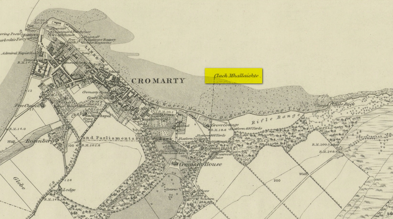
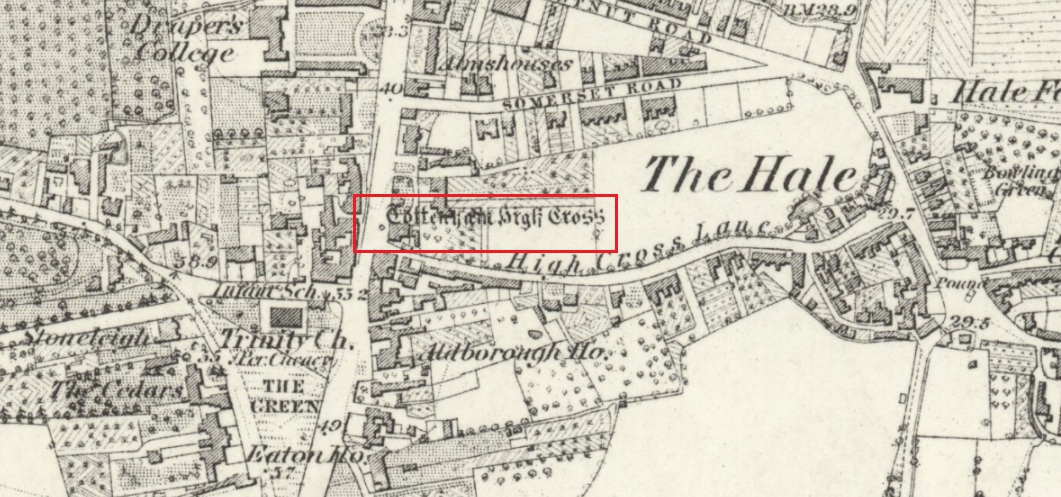
Wayside Cross: OS Grid Reference – TQ 33781 89561

Also known as:

  1. Historic England Grade II Listed Building Number 1188856

Getting Here

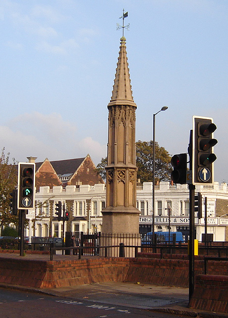
The Cross is on the east side of the A10 Tottenham High Road, on the traffic island at the Monument Way Junction.

Archaeology & History

Cross shown on 1873 map

One of the earliest records of what was called the “hie crosse” is contained in a court-roll of 1456.  It was at that time a wooden wayside cross, but there are hints that its origins may go back to Roman times.  The Cross is next to what was the southern end of Ermine Street, built by the Romans where there was no pre-existing roadway and described as the most important thoroughfare in Britain: built to give direct communication to the main centres of the military occupation at Lincoln and York.  Writing of Roman land survey marks, the now discredited early 20th century Middlesex historian Sir Montagu Sharpe (1932) thought Tottenham Cross possibly marked an earlier (i.e. Roman) stone, although no archaeological evidence has been found to support this.  As it was next to Ermine Street it could equally have been a milestone or ceremonial pillar. After the Romans left it may have become a local heathen shrine which, with the coming of Christianity, was ultimately replaced by a wooden cross—but this is speculation, and we will probably never know why and when the original cross was placed where it was.

Originally in the historic County of Middlesex, the settlement of Tottenham surrounding the Cross was known from mediaeval times to the 19th century as ‘Tottenham High Cross’.  Local historian William Robinson writing prior to 1840 thus describes the Cross:

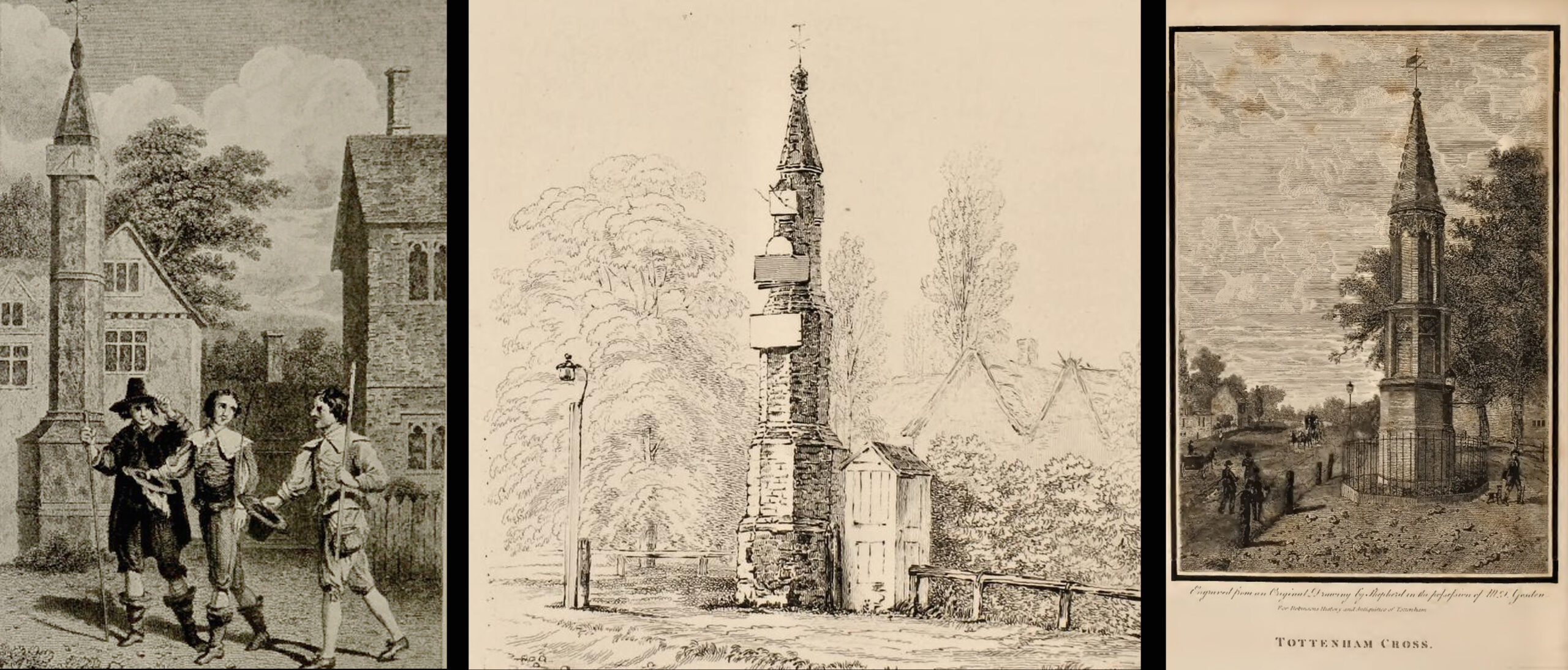
“About the year 1580, a column of wood was standing, with a square sheet of lead on the top to throw off the water, supported by four spurs: these, being decayed and rotten, were taken down, about the year 1600, by Dean Wood, Dean of Armagh, who at that time resided in a house on the east side of it, and who erected on its site an octangular brick column, pointed at the top and crowned with a weathercock, and the initials of the four cardinal points, and under the neckings, small crosses, which were called tau-crosses, according to the true cross or Greek letter T.

“Tottenham High Cross, as it appeared in 1788, was an octangular brick pillar, divided into four stories, viz.: a double plinth, first portion of the pillar; second portion, of the same; and a pinnacle; each plinth and story rendered distinct one from the other by certain appropriate mouldings ; and the whole design appeared without any kind of ornament, pointed at the top and crowned with a weathercock. The Cross having fallen into decay, several of the inhabitants of the parish entered into a subscription, in the year 1809, for the purpose of putting it into a proper state of repair, and about the sum of £300. was raised. It was accordingly repaired, and covered with Parker’s cement. The octangular plan, and the proportions of the Cross in its four stories, have not been departed from ; but in other respects it is a new work ; some of the decorations seem to be formed from the exterior and interior of the chapel of Henry VIII; the double plinths or pedestals are as plain as before, but the intermediate mouldings are new; the first portion of the pillar consists of angular pilasters at each cant done with a pointed head; compartment of five turns, connecting itself with another compartment; above it diamonded, with a shield containing an imitation of the black letter. As there are eight faces to the upright, of course there are as many shields, each bearing a letter of the same cutting, beginning at the west face, TOTENHAM: in consequence of there being but eight shields, one of the T’s in the spelling has been necessarily dispensed with. The mouldings between this story and the second are worked into an entablature, with modern fancy heads and small pieces of ornaments alternately set at each angle.

“Second story—small buttresses at the angles of the octagon, with breaks and pinnacles, but no bases. The face of each cant has a compartment embellished with an ogee head, backed with narrow pointed compartments. The mouldings between this story and the pinnacle, making out a fourth story, give, at each angle, crockets, and its termination is with a double finial, but not set out in geometrical rule to the crockets below : there is at the top a vane, with N. E. W. S. The base is surrounded with a neat iron railing on Portland stone curb. The date at which these alterations were made is not placed in any conspicuous part of the structure.”

(left) engraving based on Samuel Wale’s 1759 illustration to Compleat Angler; (centre & right) 19th C views pre- and post-renovation

The craftsman who carried out the modernisation was a Mr. Bernasconia, working to the designs of a Mr. Shaw. Not everyone was pleased by the transformation. A regular contributor identified only as ‘An Architect’ made these caustic comments in the November 1809 edition of the Gentleman’s Magazine:

“Tottenham High Cross has this summer been covered over with Compo: it previously bore a simple appearance, but is now rendered of a very rich and elaborate cast, doing away in the first instance the Architectural history of the erection; and allowing it possible that there might once have been on the spot an Eleanora Cross, holding in contempt, by a want of due imitation, the characteristic style of decoration prevailed at at the time of the Queen’s demise.  But according to the system of our Professional innovators, to destroy a sacred relick of antiquity, and to restore it as it is called, upon a model quite in a different style and nature, is one and the same thing. “Any thing is Gothick.”

“….Surveyed November 1809. Entirely covered with the proclaimed everlasting stuff, Compo; a stuff now the rage for trowelling over our new buildings, either on the whole surface, or in partial daubings and patchings; it is used in common with stone work, for instance, on an arcade, half one material, half the other; “ making good,” as it is called (abominable expedient) the mutilated parts of Antient Structures, there sticking on until it reverts (after exposure to the air for three or four years, more or less) to its first quality, dirt and rubbish, and then is seen no more….

“Provided this Compo effort had been advanced on any other occasion, and on any other piece of ground, where no piece of Antiquity was to become the spoil, such as an object to mark the centrical point of three or four counties, a general standard of miles or any other common document for the information or amusement of travellers, all would have been well, and some praise might have been bestowed, for its tolerable adherence to the above style, if not for the material wherewith it is made up. But as nothing of this sort will come in aid of the innovators, and only the barefaced presumption, “ alter or destroy, what was,” is to be encountered, let the detail of parts, put this matter to issue….”

Folklore

A modern view (Wikipedia Creative Commons)

The Cross stood in front of the Swan Inn, a place frequented by fishing writer Izaak Walton in the 1640s when he would go to fish in the nearby River Lea.  In 1653 he published The Compleat Angler describing his fishing activities in the classical form of a philosophical dialogue between him as ‘Piscator’ and ‘Venator’ (hunter) and other passing characters, starting and ending his adventures at the High Cross.  The 1759 edition of Compleat Angler contains the earliest illustrations of the Cross, with some slight artistic licence, by Samuel Wale.

Afterword

As the Cross now stands in the maelstrom of North London’s traffic, it is worth recalling American traveller Nathaniel Carter’s 1825 observation when travelling north from London:

“Passing Tottenham Cross, we entered a rich agricultural country, possessing the usual charms of English landscape.”

References

  1. An Architect (pseud.) – Architectural Innovation No. CXXXIX – The Gentleman’s Magazine, November 1809
  2. Anonymous – Tottenham High Cross, The Gentleman’s Magazine, April 1820
  3. Blair, John, The Church in Anglo Saxon Society, Oxford University Press 2005
  4. Carter, Nathaniel Hazeltine, Letters From Europe..in 1825 ’26 & ’27, G & C & H Carvill, New York, 1829
  5. Margary, Ivan D., Roman Roads in Britain, 3rd Ed., John Baker: London 1973.
  6. Robinson, William, The History & Antiquities of the Parish of Tottenham, 2nd Ed., Nicholls & Son, W. Pickering, W.B. Hunnings: London 1840.
  7. Sharpe, Montagu, Middlesex in British, Roman & Saxon Times, 2nd Ed., Methuen: London 1932.
  8. Walton, Izaak, The Compleat Angler, Facsimile of the 1st Ed., containing illustrations from the 2nd US edition by John Major, No imprimatur, 1907.

© Paul T Hornby 2020

Clach Mhallaichte, Cromarty, Ross & Cromarty

Legendary Rock:  OS Grid Reference – NH 7949 6746

Also Known as:

  1. Clach Mallach
  2. Clach na Mallachd
  3. Clackmalloch Rock
  4. Stone of Cursing

Archaeology & History

Stone shown on 1880 map

This large boulder found off the Cromarty coast, was highlighted on the 1880 OS-map of the region.  It is one of the ancient boundary stones of the township.

Folklore

We know from the vast array on the folklore of stones that many were imbued with magickal abilities, some of which were witnesses to vows and others to make curses from.  This large boulder off the coast of Cromarty was, according to Donald MacKenzie (1935), a place where the latter used to be done.  He told us:

“At Cromarty there is a big boulder known as the Clach na Mallachd (‘Stone of Cursing’).  Curses were delivered when an individual stood or knelt bare-kneed upon it.”

In an earlier account by the Ordnance Survey lads in one of their Name Books, they gave the following tale that had been narrated to them:

“A large stone Situate at the Low Water, and forming one of the boundary Stones of the burgh, the reason of its having this name is, that a young lad while Sitting on it was overwhelmed by the advancing tide and drowned, his mother when told of it, cursed the stone, hence the name Clach Mallach (Accursed Stone)”

References:

  1. MacKenzie, Donald A., Scottish Folk-lore and Folk Life, Blackie: Glasgow 1935.

© Paul BennettThe Northern Antiquarian


Kendal Maypole, Kendal, Westmorland

Maypole (destroyed):  OS Grid reference – SD 5161 9212

Archaeology & History

Long since gone, it’s existence was recorded by, amongst others, the Kendal historian Cornelius Nicholson. (1861)  He described it in relation to one of the town crosses, that was removed due to it being “an obstruction in the street.”  The maypole too, he said,

“was another incumbrance, but indispensable, according to the custom of our forefathers.  It stood in Kirkland, opposite the house of the late Thomas Reveley, Esq., and was suffered to remain till within eighty years ago.  In the time of our good Queen Katherine, who may fairly be supposed to have partaken of the amusements, countenanced by her royal consort, the original festivity of maying and morris-dancing would be here celebrated, by the annual ceremony of “maying” when, immediately after sunrise, on the 1st of May, processions, entering the town at various inlets, streamed through the streets, with music of horns and flutes; boys with their May-gads (willow-wands twined with cowslips), and girls with their “brats” full of flowers — young and old alike joining in merry laughter, and song, and the customary chorus, “We have brought the summer home.”  When the above-named ceremonies became less fashionable, the May Pole was made the rendezvous of all the milkmaids in the neighbourhood, who came and paraded round it on Easter Mondays.  On other occasions of rejoicing, afterwards, such for instance, as terminating an apprenticeship, and the like, it became customary for young men to go and dance around it.”

The author then told that this annual village ceremony was still being performed at the beginning of the 19th century, “in the assemblage of young people in the Vicar’s Fields, on Easter Tuesday.  After spending the afternoon there, they returned in procession through the streets, threading grandy needles.”

References:

  1. Nicholson, Cornelius, The Annals of Kendal, Whitaker & Co.: London 1861.

© Paul BennettThe Northern Antiquarian

Horley Green Spa, Halifax, West Yorkshire

Healing Well:  OS Grid Reference – SE 10263 26561

Also Known as:

  1. Horley Green Well
  2. Spa Well

Archaeology & History

William Alexander’s 1840 sketch of the Spa house

The historian William Addison (1951), in his history on the subject, told how “the spas began as holy wells”; and although no direct accounts are left of early dedications here, the remnants of Mayday traditions tell us there were more archaic goings-on before the waters were taken by the aristocrats.  Once it had been designated as a spa, the waters were covered and a typical Spa House constructed over them.  From hereon, for more than a century, the waters were accessible only to those with money who wished their ailments to be treated.

Between the end of the 18th to the end of the 19th century, the Horley Green Spa was a very prominent ingredient in the history of Calderdale.  A chalybeate or iron-bearing spring, its waters were directed into a large underground cistern covered by metal.  Thomas Garnett (1790) was the first to write about it, telling us:

“The Horley Green water is quite pellucid—sparkles when poured out of one glass into another—and has a sharp, aluminous, styptic taste, not unlike ink. The taste is not unpleasant when the water is taken from the springhead and drank immediately.”

He went on to espouse the waters to be good in healing bone and rheumatic diseases, giving many first-hand accounts from people in Yorkshire and beyond who used the waters here with apparent success, including one case of curing diabetes!  Its reputation was later reinforced in a book by William Alexander (1840), who told us how,

“I unhesitatingly affirm that the Horley Green Spa possesses a very strong claim to be regarded as a powerful tonic and chalybeate.”

By the time those words were written, it had already gained a considerable reputation and many were those who’d received treatment.

Spa House on 1894 map

A years after Alexander, the roving doctor A.B. Granville (1841) visited Horley Green—who described it as “a renowned steel-water Spa”.  But at the same time he reported how its popularity had started to decline.  But, via one Mr West, he did leave us with a greater chemical analysis of the Horley Green waters in an attempt, once more, to certify and prove its curative properties.  Their results found the waters to possess, in varying quantities, lime, magnesia, silica, iron oxide, sulphur and silica—all of which further attributed the science of its medicinal actions.   A number of case histories of the people cured here can be found in the works of Granville, Garnett and Alexander.

The well-house that stood here eventually fell into disuse.  When it was eventually restored as someone’s home in the the late 20th century, the disused spring was found beneath the foundations, filled with stones.

Folklore

Horley Green’s spa well came about as a result of local people visiting the site around Beltane, probably for centuries before the aristocrats and early pharmacists took their hand to the place.  But once the spa became renowned, people could only gather here “on the first Sundays in the month of May,” with Sunday being that legendary ‘day of the lord’ crap, to which the people would abide to save them from prosecution.  It is obvious though that it had been used as a place of magick thanks to the snippets of lore which have found their way into local history books.  We read how, at 6am, people gathered here, to such an extent that the roads were completely crowded.  Those who arrived first were given bags of nuts: an archaic traditional motif found at many pre-christian wells in Britain.  Occultists and ritual magickians amongst you will note the time when folk frequented the well, at 6am: the time when many nature-spirits are invoked for full effects.  We find this time echoed in the ritual gatherings at Lady or St. Anne’s Well in Morley, just a few miles to the east.

References:

  1. Addison, William, English Spas, Batsford: London 1951.
  2. Alderson, Frederick, The Inland Resorts and Spas of Britain, David & Charles: Newton Abbot 1973.
  3. Alexander, William, The Horley Green Mineral Water, Leyland & Son: Halifax 1840.
  4. Alexander, William, “On the Mineral Springs of the Parish of Halifax,” in Proceedings Geological & Polytechnic Society, West Riding, Yorkshire, volume 1, Edward Baines: Leeds 1849.
  5. Crabtree, John, Concise History of the Parish and Vicarage of Halifax, Hartley & Walker: Halifax 1836.
  6. Garnett, Thomas, Experiments and Observations on the Horley-Green Spaw, near Halifax, George Nicholson: Bradford 1790.
  7. Granville, A.B., Spas of England, Henry Colburn: London 1841.
  8. Hembry, Phyllis, The English Spa 1560-1815, Athlone Press: London 1990.
  9. Short, Thomas, The Natural, Experimental and Medicinal History of the Mineral Waters of Derbyshire, Lincolnshire and Yorkshire, privately printed: London 1724.
  10. Short, Thomas, A General Treatise on Various Cold Mineral Waters in England, privately printed: London 1765.

© Paul BennettThe Northern Antiquarian


Thorrisdail Stone, Torrisdale, Sutherland

Cup-Marked Stone:  OS Grid Reference – NC 66556 61609

Also Known as:

  1. Torrisdale Stone

Archaeology & History

Difficult to reach, this large protruding rock on the west side of Thorrisdail Hill, was known as the Thorrisdail Stone in the old boundary records.  It’s a bittova giveaway when you find it, as its name is inscribed on the lower face of the stone – etched a century or two ago by the look of it.

Thorrisdail Stone, with Sarah stood below
One of the cupmarks highlighted, upper middle

It’s a difficult rock to climb upon if you aren’t used to such things – and you need to do this if you want to see the cupmarks; although they’re hardly worth seeing unless you’re a petroglyph freak!  If you go to the trouble so see them, make sure to squat down carefully, being even more careful not to fall off (you’re screwed if y’ do).  Once in position, you’ll see between three and five very faint shallow cups etched onto its flat surface.  You can just make one of them out in the photo here.  The more impressive thing to see here is the small standing stone that seems to artificially crown the top of the rounded hill to which the Thorrisdail Stone is attached.

AcknowledgementsHuge thanks to Sarah MacLean for her company and landscape knowledge in visiting this and other nearby antiquarian remains. And to Aisha Domleo, for getting me into this neck o’ the woods.

© Paul BennettThe Northern Antiquarian

St. Bennet’s Well, Cromarty, Ross & Cromarty

Holy Well:  OS Grid Reference – NH 7923 6502

Archaeology & History

St Bennets Well 1880 map

An old church dedicated to St Bennet once existed on the hill above where this spring of water emerges, but little is now left of the building.  Thankfully the holy well hasn’t quite followed in the footsteps of the church.  Miss Riley (1935) told us that it can be found “near the high-water mark…situated at the foot of a beautiful little glen which runs inland from the coast” – and from all accounts it is still there.

Shown on the 1880 OS-map of the region, the dedication to St Bennet is obscure.  Mr Pullan (1927) suggested it derived from the 6th century St Benedict of Nursia, but this is improbable.  The Royal Commission lads thought it more likely derived from “a Celtic foundation.”

Folklore

The earliest description I’ve found regarding the traditions surrounding this well are by Hugh Miller (1835).  He wrote:

“It is not yet twenty years since a thorn-bush, which formed a little canopy over the spring of St. Bennet, used to be covered anew every season with little pieces of rag, left on it as offerings to the saint, by sick people who came to drink of the water.”

But the tradition didn’t die out, as evidenced by a short article by Miss M.D. Riley (1935) in Antiquity journal where she gave us further valuable information about its folk history, saying:

“In order to insure the fulfilment of the wish it is essential that the wisher should drink the water and leave something of his personal attire.  When the writer visited the spot there was a heterogeneous collection of ‘rags’ hanging on the branches.

“Mr Francis Scott tells me that the site is locally supposed to be the place of judgement.  It is close to the ruins of St Bennet’s Chapel and the ground is said to be cursed as it was stoeln by the Church. Even at the present day the owner has to provide each year at Christmas-tide 8 cwt of oatmeal free for the poor of the parish.  This has been operative since 1630 and though the owner has tested the matter in the highest court of law in Scotland, his appeal was not allowed.”

The tradition of giving offerings to the spirit of this well was still recorded in 1966.

References:

  1. Hiley, M.D., “Rag-Wells,” in Antiquity, volume 9:4, December 1935.
  2. Innies, Cosmo, Origines Parochiales – volume 2:2, W.H. Lizars: Edinburgh 1855.
  3. Miller, Hugh, Scenes and Legends of the North of Scotland; the Traditional History of Cromarty, William Nimmo: Edinburgh 1835.
  4. Morris, Ruth & Frank, Scottish Healing Wells, Alethea: Sandy 1982.
  5. Pullan, L., The Banner of St Boniface, London 1927.

© Paul BennettThe Northern Antiquarian

Rocking Stone carving, Rocking Moor, North Yorkshire

Cup-and-Ring Stone:  OS Grid Reference – SE 11050 57852

Getting Here

Site shown on 1854 map

Visiting this site is a bittova walk across the moors, with probably the best route being along one of two footpaths from near the Outdoor Centre following (whichever is your preference) the moorland track or path westward onto the open landscape.  Tis a 2½ mile walk before you reach two large buildings stuck high up in the middle of nowhere.  Y’ can’t miss them.  Equally unmissable is the large blatant rocking stone between the buildings.  Gerron top of it!

Archaeology & History

Rocking Stone, in situ

This impressive-looking rock that sits between the two buildings has a number of cup-markings of varying sizes across its topmost surface: some deep and some not-so-deep.  There are perhaps as many as 20 of them on different parts of the stone, but some have been intruded on by more recent graffiti.  On a recent visit to the site, photographer James Elkington and his young assistant MacKenzie, saw what looked like “a very faint ring around one of the cups” – which doesn’t surprise me.  On one section of the stone we see a fascinating series of natural curves and geological undulations, some of which may have been modified a long time ago when the cupmarks were etched.  But whether they were added to or not, it’s more than likely they’d have had some significance in the mythic nature of the rock.

The earliest description telling us that this possessed any prehistoric attributes seems to have been written by William Grainge (1871), in his huge work on the history of this region. He told that,

Faint ring highlighted
Some of the many cups

“This rock…is eleven feet in length, seven feet six inches in breadth, and two feet six inches in thickness.  The whole of the upper surface is thickly indented and grooved with cups and channels; the artificial character of which can be easily seen by anyone.  This logan rests upon a lower rock, the upper surface of which is about three feet above the ground, fourteen feet in length, and nearly the same in breadth.”

Folklore

Curvaceous nature & cups

Although this yummy-looking geological sight no longer rocks, it wasn’t always that way.  Indeed, according once more to the pen of Mr Grainge, although “it does not rock now, it has done so within living memory” – meaning that it would have been swaying at the beginning of the 19th century.  We can only take his word for it.  Also, as with many rocking stones the length and breadth of the land this, unsurprisingly it was adjudged to have been a place used by the druids.

References:

  1. Grainge, William, The History and Topography of Harrogate and the Forest of Knaresborough, John Russell Smith: London 1871.
  2. Tiernan, D., “King George V Visited in 1911,” on Teddy Tour Teas, 5 May, 2012.

Links:  

  1. Teddy Tour Teas

AcknowledgementsHuge thanks as always to James Elkington for use of his photos – as well as his partner in crime, Mackenzie Erichs.

© Paul BennettThe Northern Antiquarian


Thimble Stones, Morton Moor, West Yorkshire

Cup-and-Ring Stone:  OS Grid Reference – SE 1088 4515

Also Known as:

  1. Carving no.77 (Hedges)
  2. Carving no.246 (Boughey & Vickerman)

Getting Here

Thimble Stones, 1851 map

You can either head up to the Twelve Apostles stone circle, then a short distance west to the Ashlar Chair and head just head west along the moorland footpath that runs parallel with the old walling for ¾-mile (1.2km).  This is the boggier route, beloved of real walkers!  The other route is from the top of the Roman Road that bisects the moor at Whetstone Gate.  From here, where the normal ‘road’ meets up with the dirt-track at the very top of the moors, take the footpath east for ½-mile (0.75km) until you reach the large cluster of rocks, just over the wall on your right-hand side.  The carving is on top of one of them there stones.

Archaeology & History

Without doubt there’s one helluva spirit to this cluster of large weather-worn rocks whose bodies gaze in every cardinal direction—and it’s a place where me and a number of earlier historians thought cup-and-rings could be found.  The first petroglyphic context of the rocks was made in the 1860s by the grand 19th century historians Forrest & Grainge (2012) where they gave it the usual druidic associations, so beloved of academics and antiquarians alike at the time.  They wrote:

Very faint cup-and-3-rings
Thimble Stones gazing south

“The Thimble Stones are a ½-mile north of the Two Eggs, with which they are nearly in line.  They are of the same outcrop of stratification and appear as though they had been pushed upwards by some force acting from beneath, breaking them up with a vertical fracture, and separating them so as to leave wide spaces between the blocks.  They are about a furlong in length and in front about 10ft in height, diminishing eastward to the level of the ground.  Two of them a few feet apart are 7ft high, and bear on their eastern angles the cups and channels which we designate the marks of Druidic consecration.”

Subsequently, in Collyer & Turner’s (1885) work they told that the rocks “bear cups on two margins”; and when the great Harry Speight (1900) came here, he found they were “bearing cups and grooves.”  Yet no-one reported any rings.  And in the countless visits I’ve made here—thinking that there must have been cup-and-rings!—no such symbols have ever cried out.  The various large ‘bowls’ and lines that Nature has carved here—some of which may have been important in ancient days—are all that the casual eyes can see.  Until now…

The local rambler and photographer James Elkington and James Turner were up here a couple of years ago.  The light was falling through a clear bright sky and so, as James likes to do at such times, he clicked his camera a few times to catch the landscape.  Clambering onto the rocks, Mr Turner unknowingly stood upon the carved rings, and when he moved his foot Mr Elkington spotted them!  And as we can see on the image above, only just, there’s a single cup-mark surrounded by a concentric triple ring.  Incredibly faint, it is without doubt the real McCoy—and the highest of all petroglyphs on these moors.  In the photo it seems that there may be other elements to the carving, but until conditions allow for a further examination, we won’t know for sure.

James is hoping to get back up there when conditions are just right so he can get clearer photos.  But if you hardcore antiquarians and petroglyph seekers wanna get up there y’selves to get some photos of your own, please send us whatever you might find.

Folklore

On the esoteric side, the Thimble Stones was a place favoured by the progenitors of the ritual magickal Order, the Illuminates of Thanateros, in years gone by.

References:

  1. Allen, J. Romilly, ‘Cup and Ring Sculptures on Ilkley Moor,’ in Reliquary & Illustrated Archaeology, volume 2, 1896.
  2. Bennett, Paul, The Old Stones of Elmet, Capall Bann: Milverton 2001.
  3. Boughey, Keith & Vickerman, E.A., Prehistoric Rock Art of the West Riding, WYAS: Wakefield 2003.
  4. Collyer, Robert & Turner, J. Horsfall, Ilkley, Ancient and Modern, William Walker: Otley 1885.
  5. Feather, Stuart, “Mid-Wharfedale Cup-and-Ring Markings,” in Bradford Cartwright Hall Archaeology Group Bulletin, 6:3, 1961.
  6. Forrest, Charles & Grainge, William, A Ramble on Rombald’s Moor, Northern Antiquarian: Bradford 2012 (1st published 1867-69).
  7. Hedges, John (ed.), The Carved Rocks on Rombalds Moor, WYMCC: Wakefield 1986.
  8. Speight, Harry, Upper Wharfedale, Elliott Stock: London 1900.

Acknowledgements: Huge thanks as always to James Elkington for use of his photos.

© Paul BennettThe Northern Antiquarian

River Barvas, Barvas, Lewis

Sacred River:  OS Grid Reference – NB 351 494

Folklore

As with traditions found all over the world, rivers and lakes had spirits, gods and rituals attached to them.  Despite us believing that no such things ever occurred in Britain and the rest of the so-called ‘civilized’ world, such things were once common.  One of the annual rites performed at the Hebridean river at Barbhas (Barvas)—and described by Alexander Fraser (1878)—is just one such example:

“The natives of Barvas had a peculiar custom on the first day of May, of sending a man across the river at (the) dawn of day to prevent any females from crossing it first, as that would hinder the salmon from ascending the river all the year through.” (Fraser 1878)

The importance of the salmon, both as an important food source and equally as a ‘sacred animal’, is known in myths and legends throughout the British Isles.  To the legendary hero-figure Finn, it played a part of him gaining supernatural wisdom, and this quality is integral to the fish itself who ate the hazelnuts of knowledge and gained such power.  In this same short piece of folklore, the time of year when the ritual should be enacted on the River Barvas is Beltane, which is renowned as the prime period in the annual cycle/calendar relating to fertility.  This element relates to maintaining the fecundity of the river and the salmon where, in this case, men crossing the waters symbolically fertilizes them to ensure the annual return of the fish.  It would be interesting to know when this custom finally died out.

References:

  1. Fraser, Alexander, Northern Folk-lore on Wells and Water, Advertiser Office: Inverness 1878.
  2. Ross, Anne, Pagan Celtic Britain, RKP: London 1967.

© Paul BennettThe Northern Antiquarian

Cradle Stone, Crieff, Perthshire

Legendary Rock:  OS Grid Reference – NN 8654 2272

Also Known as:

  1. Canmore ID 25498

Getting Here

Cradle Stone on 1866 map

A bit troublesome to locate if you don’t know the area.  Get into the town centre where the paved St George Square is by the main road.  Cross the road and go up Hill Street, which runs straight into Ferntower Road.  A few hundred yards up turn left up Ewanfield, all the way to the very end at Crieff Hydro.  From here you’ll see the path uphill by the tennis courts.  Walk up and past the holiday chalets until your hit the road that curls round the bottom of the woods.  Go along until you find the car park and just above here by the roadside is a tourist board showing the Knock Walk footpath. The Cradle Stone is about 250 yards up the Knock Walk from here, 100 yards into the woods on the right.

Archaeology & History

This large broken boulder is the result of it once living further up the hillside.  One of Nature’s great forces then kicked the olde fella and he rolled down the hill to its present position.  It was mentioned in a detailed 19th century geological survey by Mr Thomson (1836), where he told:

“At Crieff, in Perthshire, there occurs a series of low hills running parallel to the Grampians.  These hills consist of old red sandstone and greywacke.  On one of them, the Cnock, the village of Crieff is built.  Upon the south-east side of this hill, towards the southern extremity, not far from the summit, there are deposited a number of boulder stones of syenitic granite. The largest of these is called the ‘Cradlestone’.  It is nearly spherical, quite smooth on the surface, and 29 feet in circumference.  It has been split in two by lightning, (according to the tradition of the place,) and one of the fragments has made one complete revolution down the hill and then stopped.  The weight of this boulder is about 30 tons.  The nearest mountains of syenitic granite, are those in the neighbourhood of Bennevis, distant more than 60 miles north-west…”

The stone was subsequently entered in Fred Cole’s (1911) outstanding survey of the local megaliths, although acknowledged it has having no archaeological pedigree.  The Cradle Stone, he wrote, is

“the appellation printed in Old English lettering on the Ordnance Map, given to one of two huge boulders difficult to find in the fir-woods at the western extremity of the Knock, and at a height of nearly 600 feet,  midway between Knockearn House and Culcrieff.   On visiting the site, the conclusion became apparent that these two blocks were merely natural curiosities, and had no interest for the archaeologist beyond the name.”

Folklore

In volume 10 of the New Statistical Account it was told how local folklore attested the Cradle Stone as being where the babies came from, perhaps intimating some fertility legend long since forgotten.

The main thing attached to this giant broken stone is the old folk-tale that used to be more well-known in the 19th century than it is today.  It was narrated at length in Macara’s (1881) fine pot pourri of local histories and legends and which I hope you can forgive me citing in its entirity here:

“In the memory of men still living, two well-known weavers, named James Livingstone and James M’Laren, lived in Barnkettick, at the west end of the town. Livingstone was a thorough wag, and M’Laren was somewhat of a simpleton. Livingstone was in the habit of telling his neighbour all sorts of extravagant stories about ghosts and witches.  The facility with which the latter fraternity could turn themselves into hares and scamper about was an accepted fact, which M’Laren as truly believed as his Bible.

“The Rocking or Cradle Stone on the brow of the Knock, behind the town, was supposed to be of Druidical origin, and for ages drew forth the fear and wonder of the natives. A belief prevailed that something valuable was buried in its foundation, and worth lifting, if it could only be got at.  Livingstone having heard of “Whang, the Miller” directed McLaren’s attention to the subject of valuable treasure being beneath the cradle stone, which was greedily swallowed, and he expressed his astonishment that no one tried digging for it.

“Livingstone suggested that they both should try it, and divide the spoil. M’Laren agreed, and it was resolved to make the attempt that night after dusk.  The necessary picks and spades were soon borrowed.  Livingstone called on an acquaint- ance or two, and informed them of the “ploy,” and they readily agreed to arrange and have some fun at the “howking” of the treasure.

“The acquaintances were up at the spot early, with a view to set some snares for hares, so that the journey would combine pleasure with profit.  They had also provided a few “squibs” for contingencies.  At the time appointed the two weavers, with their implements on their shoulders, arrived at the stone and set to work.  M’Laren did so with strong impressions of a coming calamity, which soon made him feel the greatest terror.  Livingstone worked with a will, and upbraided M’Laren with cowardice.

“With that a strange, unearthly sound came up the hill, and on looking round, a ball of fire was seen careering through the underwood.  M’Laren felt queerish and almost speechless. Another hissing sound was heard, and the strange fire came nearer.  Livingstone still wrought on, telling M’Laren never to heed, as these things were only bits of falling stars.  M’Laren thought otherwise. They were in the neighbourhood of Monzie, where it was certain there were plenty of witches, and it was evident something “no canny” was brewing.  He would have given anything to have been at his loom.

“In an instant three or four fiery darts from different directions came hissing along, and darted through the heath at their feet.  M’Laren was paralysed with fear.  Livingstone ceased work instantly, and jumping out of the trench he made, yelled he smelt brimstone, rushed from the stone and was lost in the darkness.  Poor M’Laren’s limbs trembled like a leaf and were scarcely able to support him.  As he was trying to follow his companion, another fire shower rained about him, and down the hill he went like a deer, yelling on Livingstone to wait on him.

“As he neared the parks above Milnab, the hares acid rabbits were scampering in all directions, and a few found their necks in the snares, which caused them to squeal at the pitch of their voices too.  M’Laren being now thoroughly convinced that the witches were let loose, speed was added to his limbs, and with supernatural fleetness he bounded over all obstructions and found himself in an instant or two in his room, and jumped into bed.  A cold sweat broke out all over his body and his heart beat with sharp thuds, shaking the bed.  It was some time ere he could collect his scattered senses, so as to realise whether or not he was dreaming. The moisture in his eyes caused every blink of the fire to appear like the horrid hissing fire darts of the Knock. After a time he fell into a stupor, the recent events being still vividly before his mind.

“His cronies on the Knock tumbled amongst the heather and broom, shouting with joy at the success of the scheme.  After giving vent to their excited feelings they went back to the Cradle Stone and lifted the picks and spades, and on their way home went round the snares and found a good “take.”  As they were killing the hares, Livingstone suggested that a live one be taken to M’Laren, which was readily agreed to.  On reaching home, Livingstone slipped into M’Laren’s house, and all seemed at rest.  Creeping quietly ben to Jamie’s end of the bigging, he tied the live hare to the foot of his bed.  As he was retiring he jostled against the hen roost and set the cock a-crowing, which so far roused Jamie that he thought it was scarcely morning yet.  The cock crowed away, and soon the neighbouring roosts bestirred themselves, and all the cocks in the neighbourhood returned the vocal sound, as if it were morning.

“Poor Jamie, on reflecting, resolved that if he got over the present raising of “Auld Clootie” scathless, he would pledge himself never to trouble him or his again.  As he thus pondered he thought he heard a strange pattering on the floor, and an occasional slight pull at the bed.  On straining his eyes and looking floorwards he saw something not unlike a reputed witch moving about the foot of the bed.  On closer observation this was fully confirmed, and he instinctively roared for help.  His daft brother was now roused, and he roared also, and the hamlet dogs lent a willing voice.  The wags who had collected outside rushed in, and on putting some fir roots on the fire the blaze showed Jamie, nearly demented, in bed, with his wearing clothes still on, and some dogs entering the room set a-worrying the hare.  At the sight of well-known faces Jamie jumped out of bed.  So much excited that it was feared that the joke had been carried rather far.  Livingstone was still equal to the occasion, and drawing a bottle of whisky from his pocket handed round a few glasses, and in a short time “they didna care for deils a boddle.”  Jamie was advised to divest himself of his clothes and go to bed, which he did, and soon fell into a deep sleep, and awakened next morning not much the worse.  The affair got wind, and many a country fireside was made merry by the story of the Cradle Stone treasure.”

References:

  1. Coles, Fred, “Report on Stone Circles Surveyed in Perthshire, Principally Strathearn” in Proceedings of the Society of Antiquaries, Scotland, volume 45, 1911.
  2. Macara, Duncan, Crieff: Its Tradtions and Characters, D. Macara: Edinburgh 1881.
  3. Thomson, Thomas, Outlines of Mineralogy, Geology and Mineral Analysis – volume 2, Baldwin & Cradock: Edinburgh 1836.

Acknowledgements:  Big thanks for use of the 1st edition OS-map in this site profile, Reproduced with the kind permission of the National Library of Scotland

© Paul BennettThe Northern Antiquarian