Cup-and-Ring Stone: OS Grid Reference – c. NT 65 20
Archaeology & History
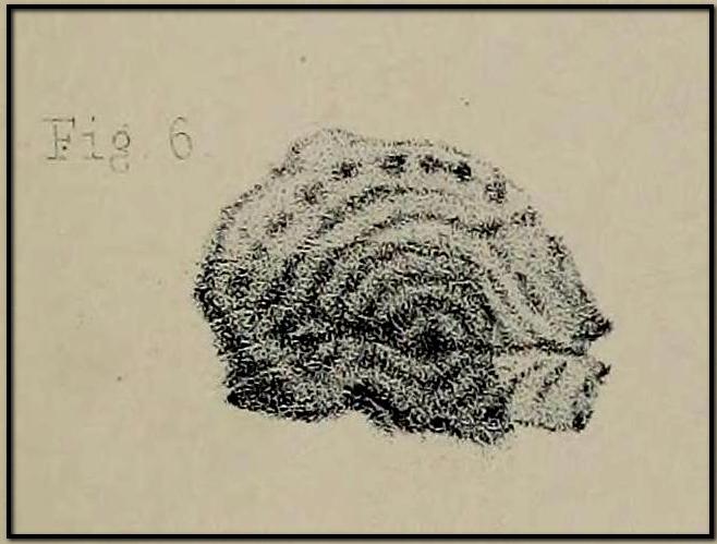
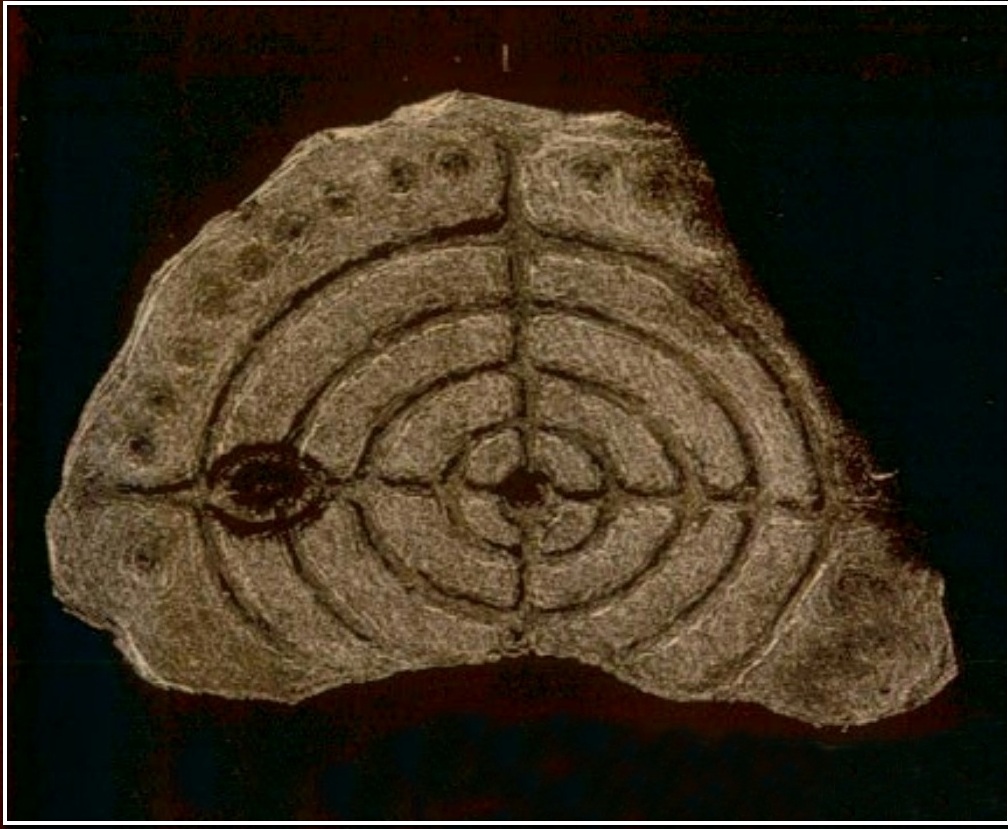
Apart from the petroglyph found at Jedburgh Abbey in 1903, there’s a distinct lack of known cup-and-ring stones in this area; so when the petroglyph pioneer George Tate was in town in 1860, he was fortunate to find a small “portable” stone with a rather impressive design on it. We don’t (yet) know the exact position of where the stone was located, as Tate simply told how,
“Lying among a heap of stones in Mr. Adam Mathewson’s garden, I detected, on a much weather-worn block, defaced sculpturing of the same family character as those in Northumberland. …There are five concentric circles, central cup, radial grooves, and a string of cups around the outer circle. Forty years ago this stone was built into the wall of a house; but whence it originally came is not known. Doubtless it belongs to the district, and probably had been connected with an interment.”
His final remark would seem most likely and has subsequently been echoed by several other rock art students. A few years after Tate’s initial find, the carving was mentioned in Sir James Simpson’s (1867) classic work, who told us:
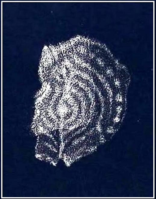
Dr Falla’s 1866 sketch
“Sometime ago Mr Tate, of Alnwick, discovered in the garden of Mr Matthewson at Jedburgh a stone cut with concentric circles, possibly a sepulchral cist, but peculiar in some respects. The stone is roundish, but broken off at one side, and about eighteen inches broad. Its face is covered by five incised concentric rings, and through the central cup pass at right angles two straight lines, which completely bisect all the circles. The outermost circle is about fourteen inches in diameter. Some inches to the left of the central cup is a second, with one incised circle around it. Arranged circularly outside of the outermost circle is a series or ring of points or stars, each cut out—so Dr Falla writes me—”as with a single stroke of a pick, rather than hewn out.” I am indebted to the same gentleman for the sketch of this stone.”
Subsequently all other written accounts repeat the same basic description—and each account remained (as we still are) perplexed as to its original location, wondering where on Earth the Rev Adam Mathewson’s garden was in Jedburgh (surely someone must be able to find out?!). Thankfully the carving itself has been saved and presently lives in the Kelvingrove Art Gallery and Museum, Glasgow. Whether it ever had any relationship with the petroglyph at Jedburgh Abbey, we don’t yet know.
References:
Laidlaw, Walter, “Sculptured and Inscribed Stones in Jedburgh and Vicinity,” in Proceedings Society Antiquaries, Scotland, volume 39, 1895.
Morris, Ronald W.B., “The Cup-and-Ring Marks and Similar Sculptures of South-West Scotland,” in Transactions of the Ancient Monuments Society, volume 14, 1967.
Morris, Ronald W.B., “The Cup-and-Ring and Similar Early Sculptures of Scotland; Part 2 – The Rest of Scotland except Kintyre,” in Transactions of the Ancient Monuments Society, volume 16, 1969.
Morris, Ronald W.B., “The cup-and-ring marks and similar sculptures of Scotland: a survey of the southern Counties – part 2,” in Proceedings of the Society of Antiquaries, Scotland, volume 100, 1969.
Morris, Ronald W.B., The Prehistoric Rock Art of Southern Scotland, BAR: Oxford 1981.
Royal Commission on the Ancient & Historical Monuments of Scotland, Roxburghshire – volume 1, HMSO: Edinburgh 1956.
Simpson, J.Y., “On Ancient Sculpturings of Cups and Concentric Rings,” in Proceedings of the Society of Antiquaries, Scotland, volume 6, 1866.
Simpson, James, Archaic Sculpturings of Cups, Circles, etc., Upon Stones and Rocks in Scotland, England and other Countries, Edmonston & Douglas: Edinburgh 1867.
Tate, George, “The Ancient British Sculptured Rocks of Northumberland and the Eastern Borders,” in Transactions of the Berwickshire Naturalists Club, volume 5, 1864.
It’s easier to explain how to get here if you’re coming from the Burnsall-side of the B6160 road that leads to Bolton Abbey. A half-mile out of Burnsall village you a small woodland with a small parking spot. From here, a footpath runs up the steep hill above the parking spot. It zigzags a little and you eventually come out on the south-side of the trees where it meets some tall walling. Follow this walling further uphill for more than 600 yards (past more woodland) until the land starts to level out. Hereby, go thru an opening in the wall and less than 100 yards away (west) amidst the overgrown heather, you’ll see what you’re looking for.
Archaeology & History
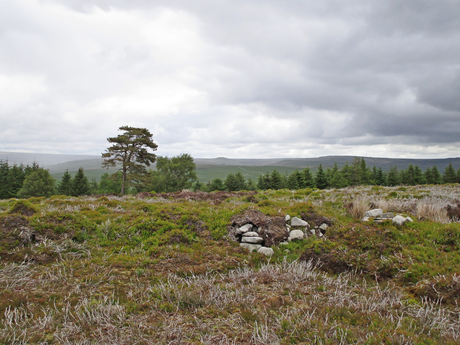
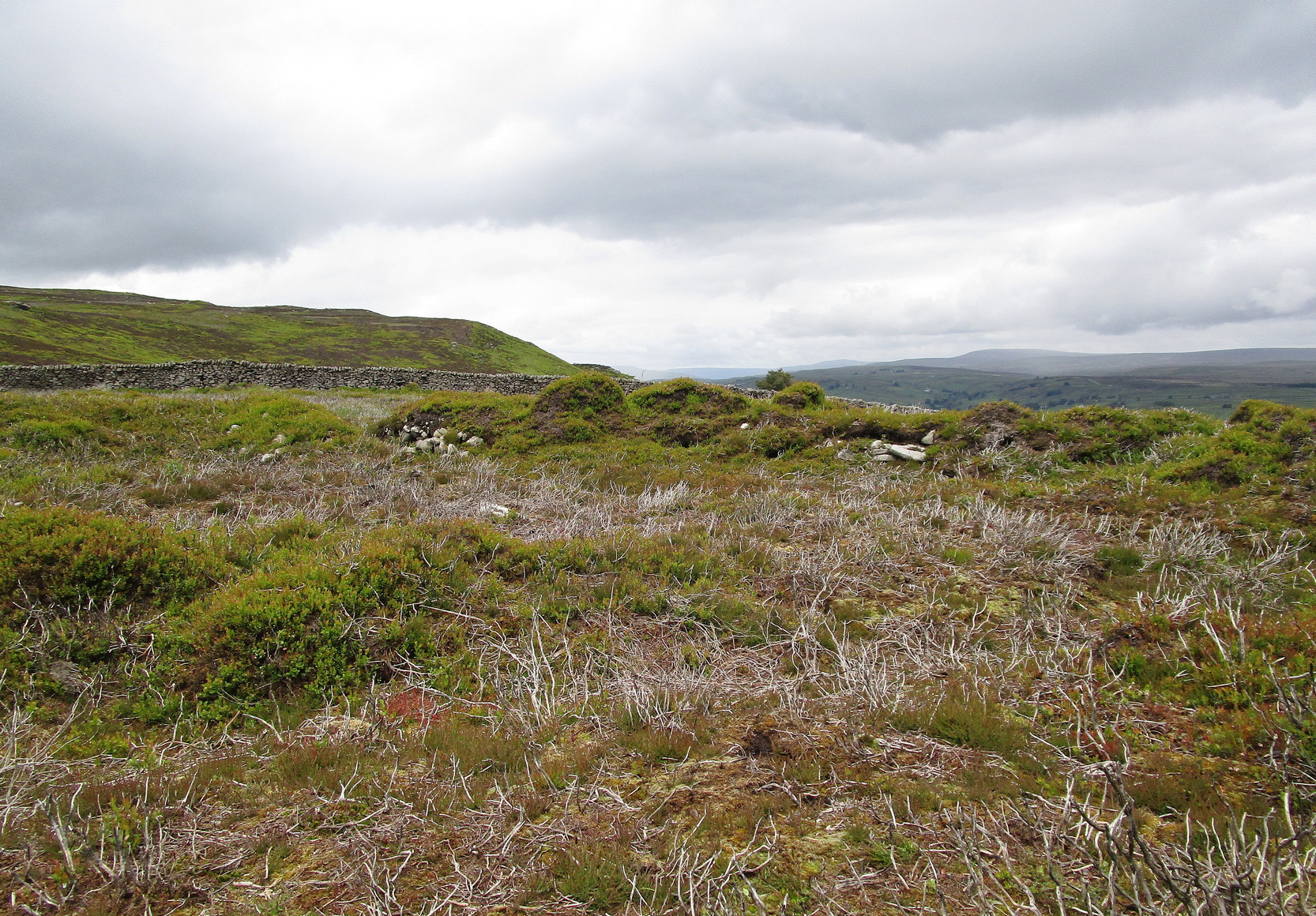
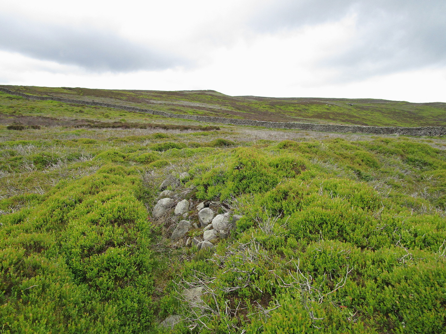
A large but peculiar site resting on a moorland plateau on the eastern edges of the mighty Barden Moor. Peculiar inasmuch as it’s completely isolated from any other monument of the same age and type anywhere on these huge moors. A few miles east, on the moors around Appletreewick, Thruscross and Beamsley we have a plethora of prehistoric sites—but up here on Barden Moor there’s apparently nowt else! I find that hard to believe….
Inner rubble wallingRubble walling, looking N
Listed on official websites as being a ring cairn, it’s difficult without a detailed excavation of the site (there hasn’t been one) so say that’s what it is. But we’ll stick with it for the time being. My initial impression of the site was that it was a crude form of a collapsed Scottish dun: impressive large circular monuments—buildings if you like—with very well-built large stone walls, usually several yards thick, a little bit like the Scottish brochs (mighty things indeed!). This thing at Folly Top isn’t quite as impressive, but it’s like a collapsed version of a dun.
Arc of western walling
The site consists of large ring of raised collapsed rubble walling, more than a yard high in places, and about three yards thick all the way round, measuring roughly 21 yards (N-S) by 19 yards (E-W) from outer wall to outer wall. There are “entrances” on the east and west sides; but there seemed to be little of any note in the middle of the ring, although the site was somewhat overgrown on our visit here. Outside of the ring there was also nothing of any note. It’s a pretty isolated monument which seems to have more of an Iron Age look about it than the Bronze Age—but until there’s an excavation, we’ll not know for sure.
It’s well worth checking out—and from here, walk onto the huge moorland above you to the west….
Acknowledgements: Huge thanks to the Crazy-gang of Sarah, Helen and James for their awesome assistance on our venture up here. A damn good day indeed! Cheers doods. 🙂
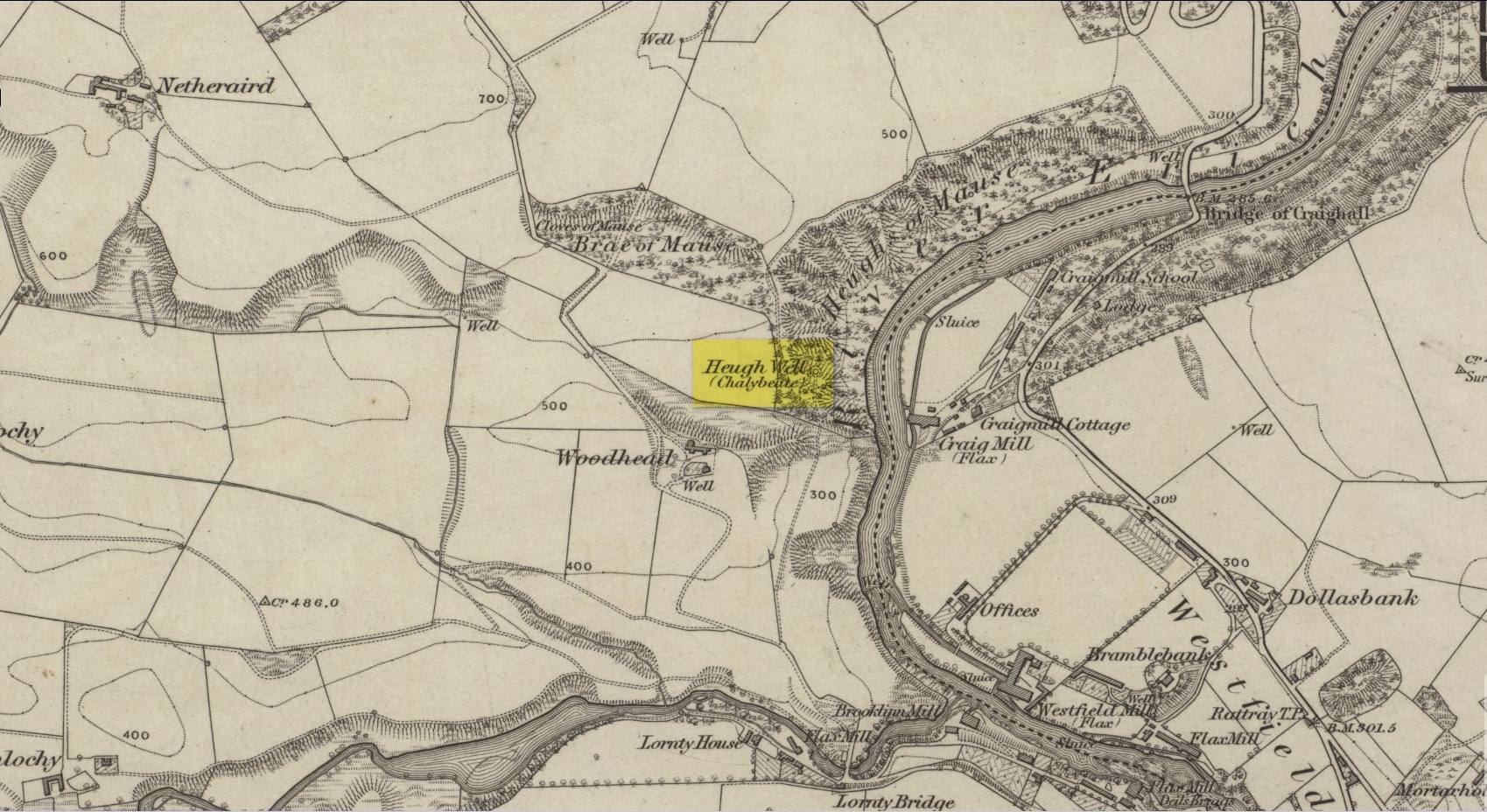
This little-known iron-bearing spring can still be found in the woodland known today as the Heugh of Mawse, a mile north of Blairgowrie. It was included in the Object Name Book of 1863, where they referred to an earlier account in the New Statistical Account, which told that,
“On the south end of it is a chalybeate spring much resorted to by the people of the locality. “There are one or two chalybeate springs in the parish; but they have never been chemically analyzed. There is one very fine spring called the “Heugh Well” It springs from the face of the “Heughs of Mause” (a mortar cliff of singular appearance; which descends abruptly into the bed of the river with an almost perpendicular declivity of about 200 feet) and judging from its colour, contains a considerable quantity of ferruginous matter. The use of its water has been found to be very beneficial in cutaneous eruptions, & affections of the Stomach.””
Heugh Well on 1867 map
Subsequently highlighted on the 1867 OS-map, a singular footpath led to the site and no further. It was mentioned by the regional historians J.G. McPherson (1885) and John MacDonald (1899), albeit briefly, where they respectively told that its waters were “formerly much resorted to by persons in the neighbourhood.” It possessed considerable medicinal properties which, according to tradition, were “found very beneficial for skin diseases and derangement of the stomach”! Doubtless such attributes will still be effective.
I add this brief site profile in the hope that we can clarify, one way or the other, whether the report of a stone circle described in a letter by G.W. Zealand to the Ordnance Survey in November, 1978, has any basis in fact. Zealand said that the structure comprised of “red stone, not very large” at Millden in Glen Esk. Perhaps local people or megalithic explorers who may visit this area could try locating it so we can confirm it as real, or strike it from the listings. It is included in the Canmore catalogues. I must point out that there were a large number of prehistoric sites in this area destroyed in recent centuries, meaning that this report may be authentic.
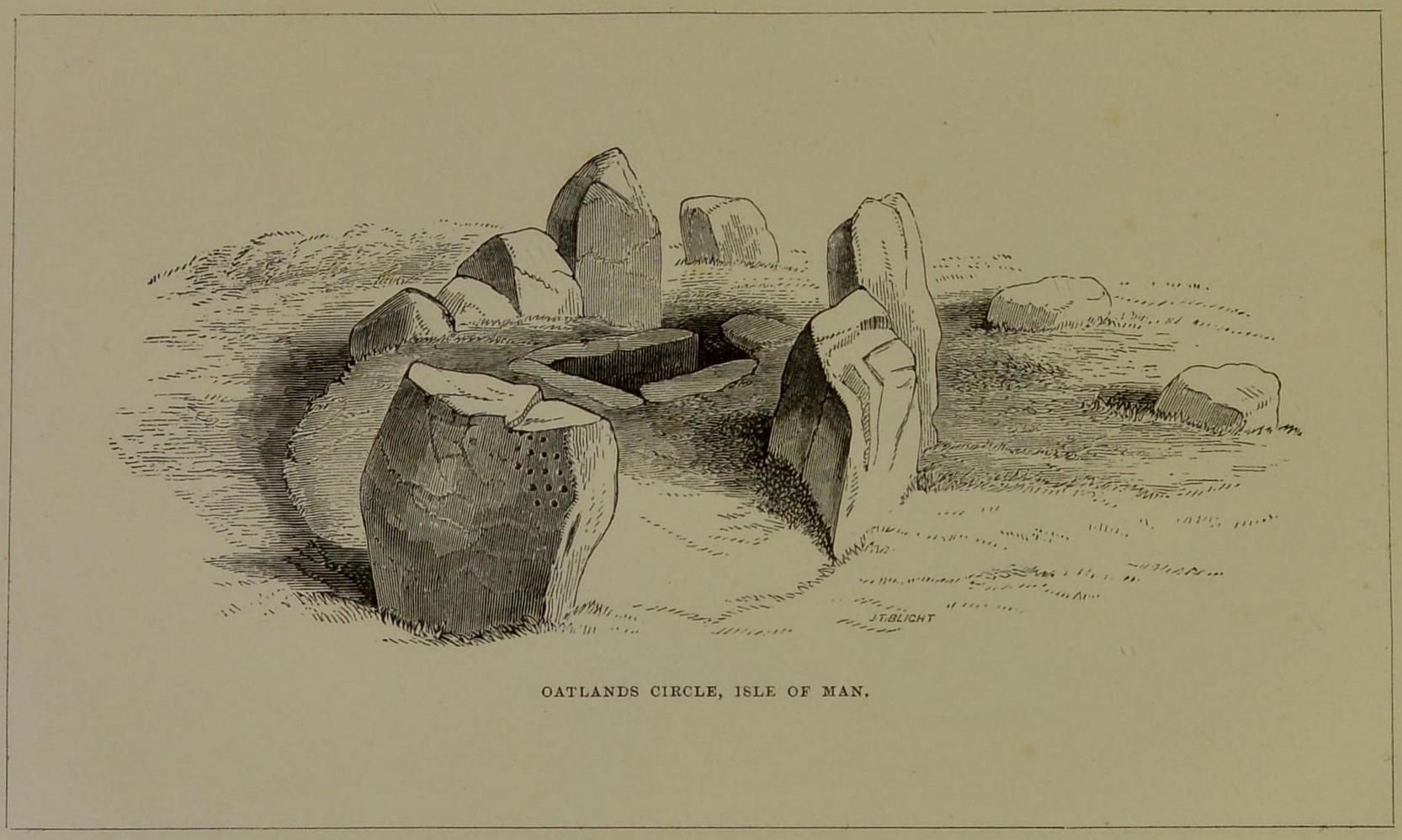
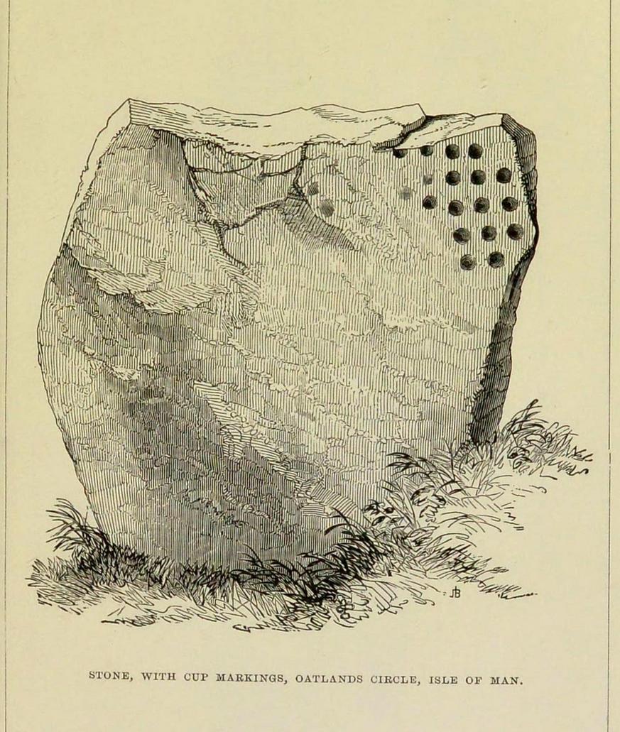
This carving is one that was found inside the remains of a chambered cairn and so, as with all things petroglyphic, it deserves its very own site profile. It’s been mentioned before—in fact many times before, from the legendary J.T. Blight (1868) to our modern researchers—although it was curiously absent in Ron Morris’ (1989) otherwise excellent survey. When Mr Blight described the tomb, he told us that,
“Its outer ring, of which but three or four stones are left, was about 45 feet in diameter; the inner one 15 feet, with a kistvaen in its midst. As on the external face of one of the uprights of the inner circle there are rows of cup carvings … it may be presumed that this was always exposed to view.”
Position of cups in the tombE.L. Barnwell’s 1868 sketch
The same year, Barnwell (1868) mentioned the same carvings—albeit briefly—telling us “that one of the stones has several rows of the curious cups.” The design faced to the north, which is the traditional direction relating to Death in most northern hemisphere cultures.
As you can see, this design is similar to other petroglyphs that some students have suggested have a numeric nature (see the Idol Stone on Ilkley Moor for example). You can understand why! The basic linearity of the cups, in rows, certainly gives that impression and indeed it’s not unreasonable to make such an assumption—but, as always, we simply don’t know. A similar design was found on a stone at Ballagawne in the parish of Kirk Arbory, but the cups were much deeper and deemed as being a medieval game played on stone, known as Nine Man’s Morris. The original function of the game may have been divinatory.
References:
Barnwell, E.L., “Notes on the Stone Monuments in the Isle of Man,” in J.G.,Cumming (ed.) Antiquitates Manniae, London 1868.
Blight, J.T., “Stone Circles and Megalithic Remains,” in Gentleman’s Magazine 1868.
Cubbon, A. M., Prehistoric Sites in the Isle of Man, Manx Museum: Douglas 1971.
Gale, J. & Darvill, T., “A Survey of the Ballakelly Chambered Tomb,” in Darvill, & T. Billown (eds.), Neolithic Landscape Project, Isle of Man, 1997, Bournemouth University 1998.
Henshall, A. S., “Manx Megaliths Again: An Attempt at Structural Analysis,” in P. Davey (ed.), Man and Environment in the Isle of Man, BAR: Oxford 1978.
Kermode, P.M.C., “The Ancient Monuments of the Isle of Man,” in Archaeologia Cambrensis, volume 84, 1929.
Kermode, P.M.C. & Herdman, W.A., Manks Antiquities, University of Liverpool 1914.
Simpson, James, Archaic Sculpturings of Cups, Circles, etc., Upon Stones and Rocks in Scotland, England and other Countries, Edmonston & Douglas: Edinburgh 1867.
Holy Well (destroyed): OS Grid Reference – NO 180 452
Archaeology & History
The Well Meadow in the middle of Blairgowrie was once the place where the 5th century Apostle of the Southern Picts, or St Ninian, baptised local folk into the so-called “new faith”. It’s long since gone. The local historian John MacDonald (1899) told that it was located opposite the buildings on the north-side of the square, adding:
“St Ninian, one of the earliest Christian Celtic missionaries, on his tour through Scotland, pitched his camp where the Wellmeadow now is, and quenched his thirst at an old well or spring which ever afterwards bore the name of “St Ninian’s Well,” until it was covered in and the water led into the town drains.”
Holy Well (lost?): OS Grid reference – SX 2258 5311
Archaeology & History
This spot is where an old field-name has preserved the memory of an all-but-forgotten holy well, known as the “Holywell Ground.” Although it may have fallen back to Earth, there are two possible spots regarding its position: i) a spring that was marked on the 1882 OS-map at SX 2258 5315, and ii) a “Well” that’s shown on the recent OS-maps (SX 2257 5306). Hence, the grid-reference I’ve given to this place is the halfway spot between them both. (it has to be pointed out that the “well” on recent maps occurs right next to an old quarry, which are well known to bring forth water sources that were previously deep underground) Whether or not Sclerder Abbey—about 400 yards west of here and only built in 1843—had anything to do with the sanctifying this well, we can but guess…
There are numerous ways to get here from all directions: i) from the west-side of Wimbledon Common, on the Robin Hood’s Way A3 road, keep your eyes peeled for the small crossroad of Robin Hood Lane and Road, obivously taking the one into the park. Keep on the dead straight Robin Hood Ride path until your hit the carpark ¾-mile on; and from here, bear sharp left (NW) for 250 yards or so, where a small slope down on your left takes you there; or, ii) from Wimbledon village side on the A219 Parkside A219 road, where the War Memorial stands, head onto the Common along The Causeway, past the Fox & Grapes going on Camp Road, then up the Sunset Road towards the carpark. And then, once again go NW for 250 yards or so, where the small slope on your left takes you there. You’ll find it.
Archaeology & History
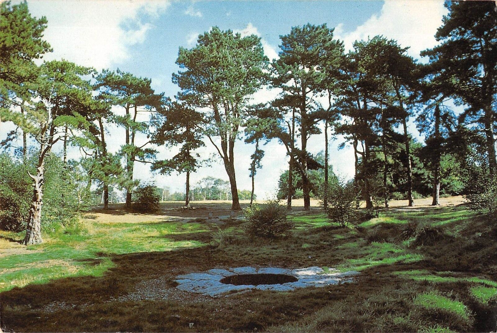
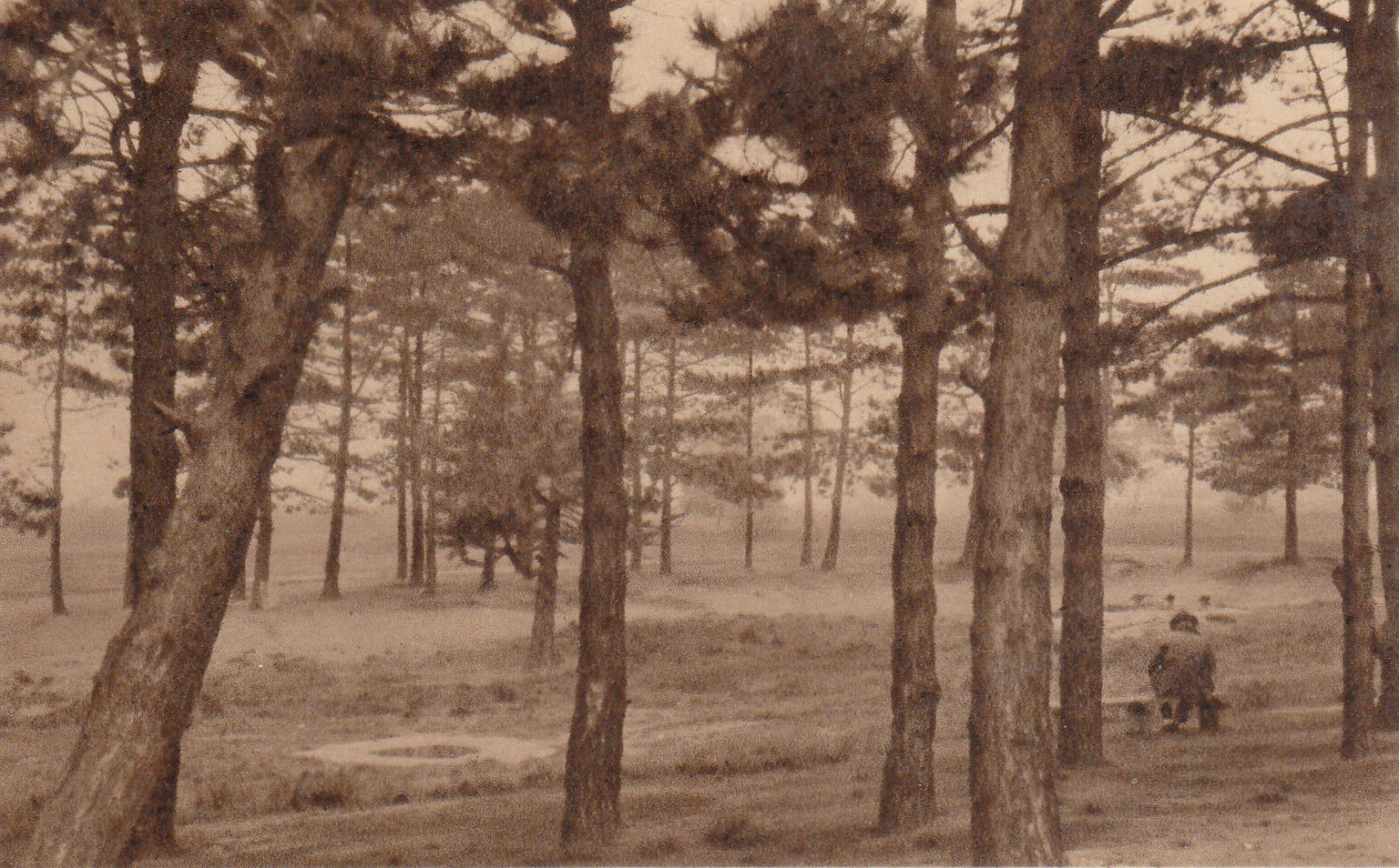
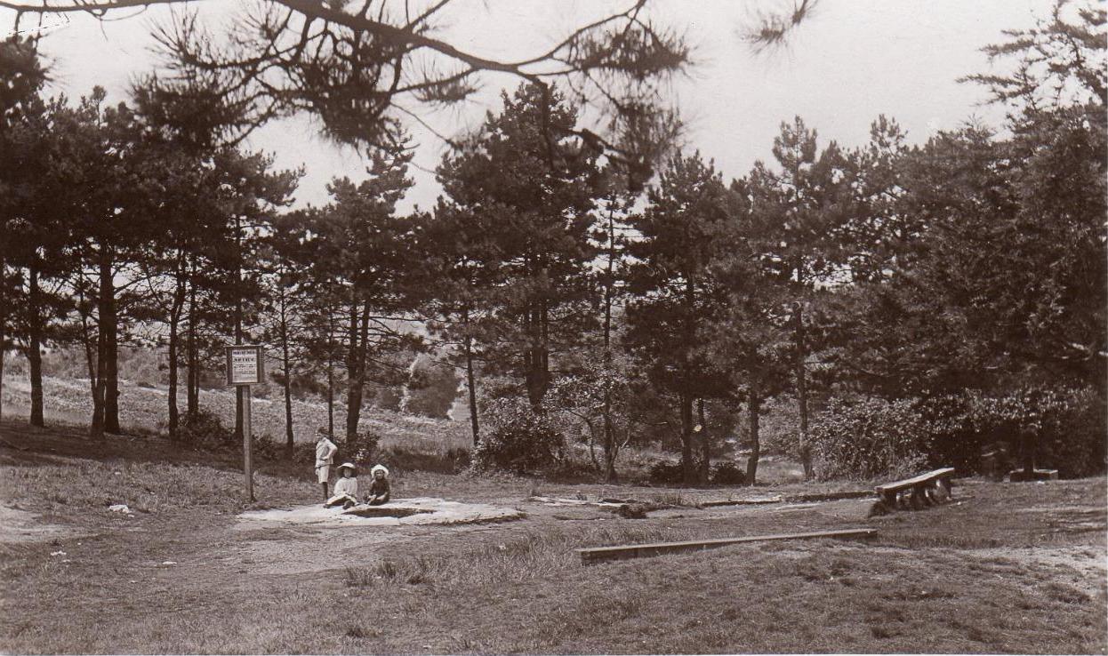
Described by William Bartlett (1865) as “the never-failing spring of water, improperly called the Roman Well”, its constant flow was severely tested in the great drought of 1976—and it kept on flowing. Only just though! It was highlighted on the early Ordnance Survey map with the plain name of the Springpond Well. The great historian and folklorist Walter Johnson (1912) gave us the best historical resumé of the site, telling that,
Caesar’s Well around 1900Caesar’s Well around 1911
“Caesar’s Well, formerly known as Robin Hood or Roman Well—the Springpond Well on the Ordnance Map—issues on the other side of the little watershed above mentioned, at a height of 149 feet O.D. The well lies in a little hollow, now ringed with Scottish pines. The gathering ground is the land to the east, rising to 198 feet O.D. This area is not large, but quite sufficient to maintain a permanent rill of pure water. The well, the waters of which once were deemed of special medicinal merit, was enclosed with brick in 1829, and, as the inscription tells us, refaced with granite blocks by Sir Henry W. Peek, M.P., in 1872. The outflowing waters descend to Brickfield Cottage, where they expand into a turbid duckpond; thence the course is through the yard behind the house, and along the north side of Robin Hood Road to Brook Cottage. During 1911 the “Well” proper altogether dried up, but water still issued from the stand spout a few yards below, which is supplied by an artificial boring and pipe that tap the spring at a depth of 18 feet.”
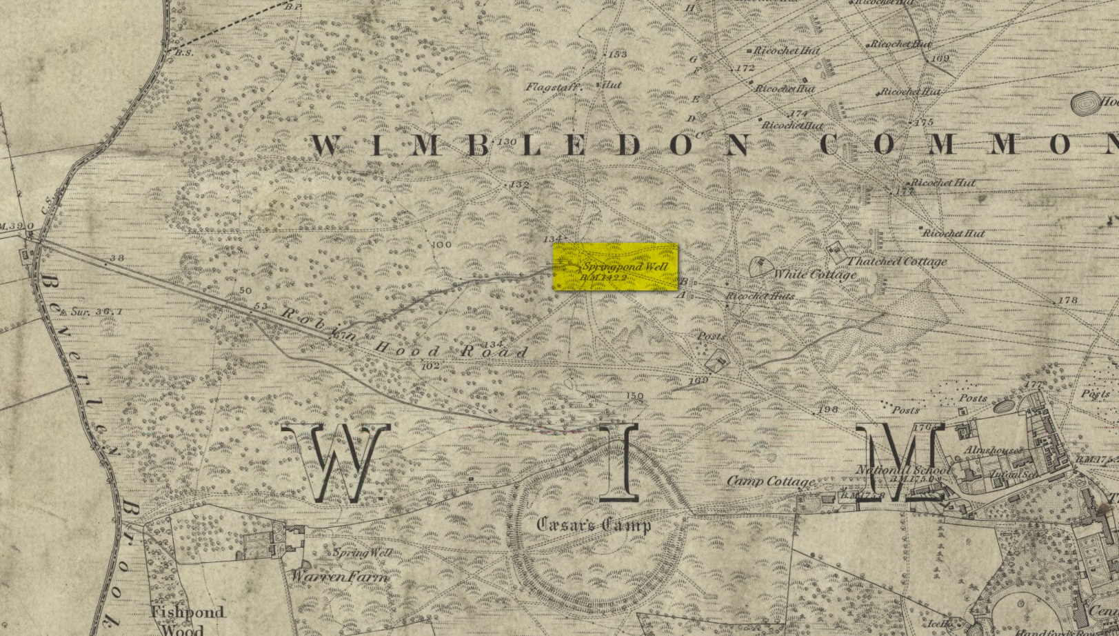
Site shown on the 1874 map
The proximity of this never-failing spring to the huge prehistoric enclosure of Caesar’s Camp just a few hundred yards to the south would indicate it was an important water source in Bronze Age times and, I’d hazard, would have been bestowed with some sanctity, as many such wells tended to be.
Folklore
James Rattue (2008) informed us that the name Robin Hood’s Well was known here in the 18th century prior to it being known as Caesar’s Well, but there seems to be no known relationship between Robin Hood and this site. However, a piece written in 1922 told that there was a lingering tradition that Julius Caesar encamped on Wimbledon Common in 51 BCE and that this folk memory was kept alive in the lore of local children who devoutly believed that the great Roman Emperor drank from the cool depths of this well.
References:
Bartlett, William A., The History and Antiquities of the Parish of Wimbledon, Simpkin Marsall: London 1865.
Hughes, John L., “Caesar’s Well, Wimbledon Common,” in Source magazine, no.9, Spring 1989.
Johnson, Walter, Wimbledon Common – Its Geology, Antiquities and Natural History, T.Fisher Unwin: London 1912.
Rattue, James, Holy Wells of Surrey, Umbra: Weybridge 2008.
Cup-Marked Stone (lost): OS Grid Reference – SO 1491 0045
Archaeology & History
Sometime in the 1940s, a certain Lady A. Fox recorded a cup-marked stone “in the vicinity of Pen-twyn” near Bargoed. Its position in the landscape is a good one: on a geological promontory and overlooking the valley below. The find was indexed by the Ordnance Survey, but apart from it’s grid-reference, all attempts to locate the design have so far proved unsuccessful.
It was mentioned briefly in the Royal Commission (1976) survey of Glamorgan, then subsequently listed in the surveys of Sharkey (2004) and Nash (2007), but none of them were able to locate it. And hence, I post it here, in the hope that some local hunter will be able to recover it from its hiding place!
References:
Mazel, A., Nash, G. & Waddington, C. (eds.), Art as Metaphor: The Prehistoric Rock Art of Britain, ArchaeoPress: Oxford 2007.
Nash, George, “A Scattering of Images: the Rock Art of Southern Britain,” in Art as Metaphor, ArchaeoPress: Oxford 2007.
Royal Commission on the Ancient & Historical Monuments, Wales, An Inventory of the Ancient Monuments in Glamorgan – Volume 1: Pre-Norman, Part 1: The Stone and Bronze Ages, HMSO: Cardiff 1976.
Sharkey, John, The Meeting of the Tracks: Rock Art in Ancient Wales, Gwasg Carreg Gwalch: Llanrwst 2004.
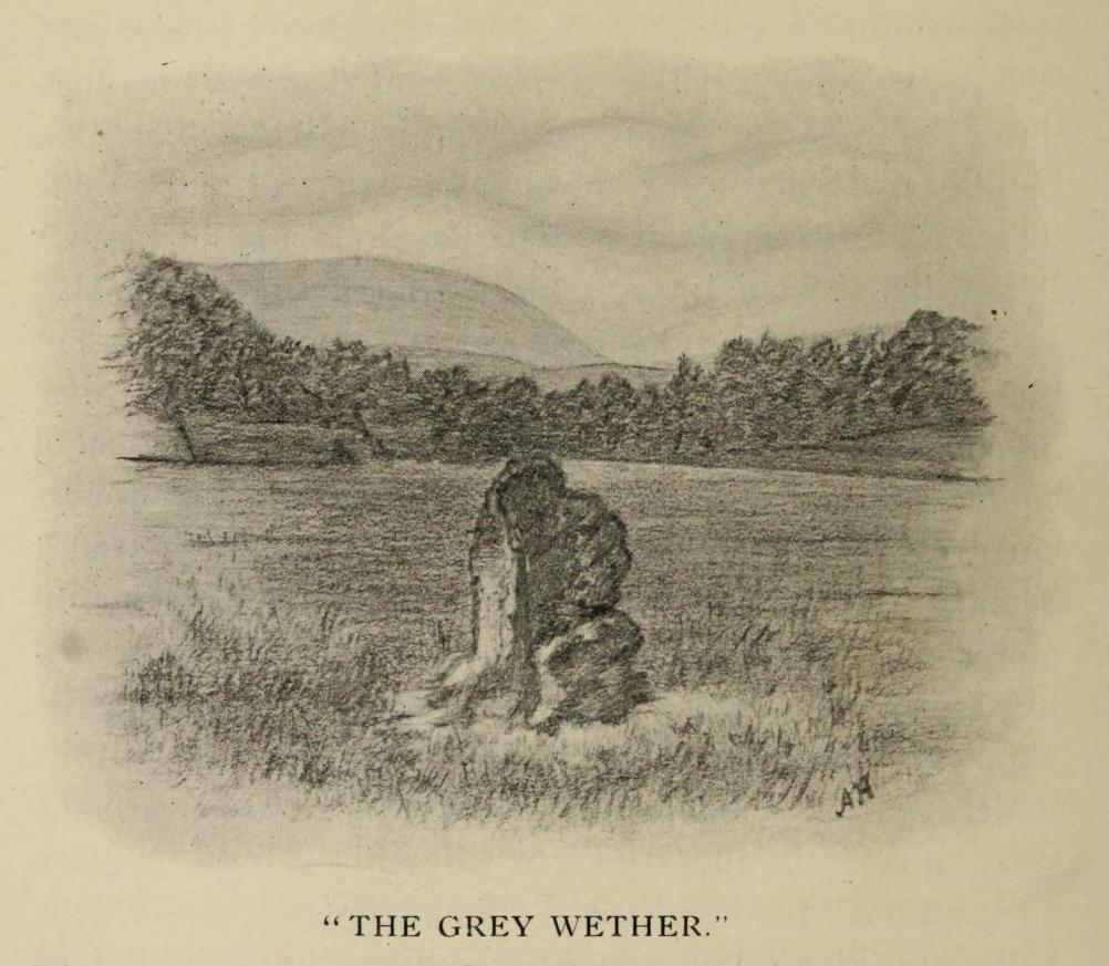
This is a site that requires the attention of some local antiquarians, as there are conflicting reports as to whether or not it still lives in its old haunt. Very little has been written about it and its whereabouts seems to have been completely missed in the radars of all megalithic guides. The Langholm historians—John and Robert Hyslop (1912)—who wrote about the place in their gigantic history work more than a hundred years ago, would no doubt be shaking their heads at such lackings.
They told:
“The best example of the standing stones in the Eskdale district is that at Meikledale in Ewes, locally known as ” The Grey Wether,” a print of which is here given. It is about 5 feet in height and its girth is 8 feet 7 inches, and it would probably weigh about two tons. The stone is the common greywacke, or whinstone of the Silurian series, rough and unhewn. It stands in the centre of a field in front of Meikledale House, and can be seen from the highway. The field is surrounded by hills on every side,”
which the writers thought might have been the reason for its erection here, although having more to do with the natural beauty of the landscape than any archaeocentric or geomantic factor.
Shortly after this had been written, Alexander Curle of the Royal Commission visited the area and made note of this “standing stone known as the Grey Wether…situated on the haughland some 250 yds SSE of Meikledale”, but added nothing more. It was several years later before a Royal Commission (1920) team came here and told that,
“A standing-stone, known as the “Grey Wether,” is situated on the haugh-land, some 250 yards south-south-east of Meikledale. It is a large whinstone slab, measuring in greatest height 4 feet 8 inches, in breadth 3 feet 5 inches, and in thickness 1 foot, and faces west-south-west and east-north-east.”
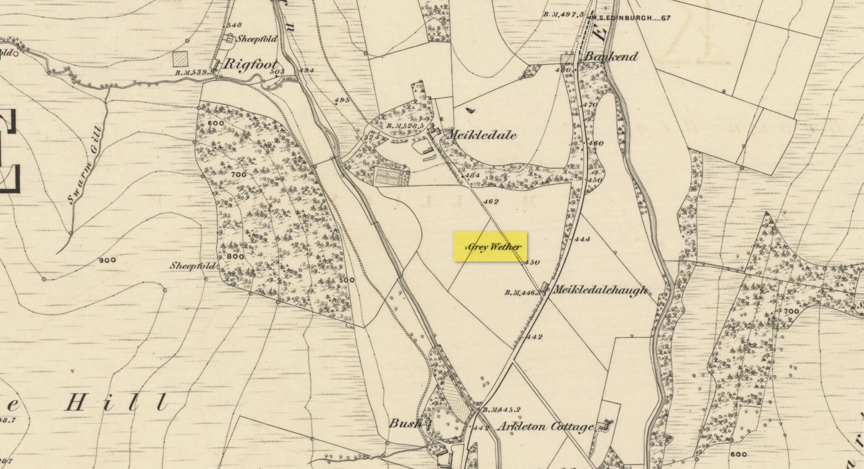
Stone shown on 1857 map
But they subsequently reported that, prior to World War 2, some complete dickhead knocked it down, broke it up and dumped it in a nearby stream! However, in 1980 some more lads from the Scottish Royal Commission revisited the area and alleged that a stone laid in the field 250 yards below of Meikledale farmhouse was our old Grey Wether. The position they describe is the same spot as the one shown on the 1857 OS-map; and at this very spot on GoogleEarth it seems that a stone there lies… Are there are any local folk in that neck o’ the woods who could find out…?
Folklore
The Greywethers stone circle on Dartmoor has a veritable mass of folklore attached to it, but its namesake here at Langholm has very little. The origin of its name has been forgotten. All we have left is what the Ordnance Name Book in 1857 recorded, telling that “it is supposed to have been erected in memory of some Hero, but no further account of it can be obtained.”
“Lying among a heap of stones in Mr. Adam Mathewson’s garden, I detected, on a much weather-worn block, defaced sculpturing of the same family character as those in Northumberland. …There are five concentric circles, central cup, radial grooves, and a string of cups around the outer circle. Forty years ago this stone was built into the wall of a house; but whence it originally came is not known. Doubtless it belongs to the district, and probably had been connected with an interment.”