Cup-and-Ring Stone (lost): OS Grid Reference – NY 3851 8149
Archaeology & History
A petroglyph that was rediscovered as recently as 2003, by J. Ward, has, it would seem, already been lost. In all likelihood it has become hidden beneath vegetation. Found near the Petrifying Well, the carving is archetypal, consisting of a single cup surrounded by two rings, on a low flat piece of rock on the south-side of the Tarras burn, only a few hundred yards above the road. I’ve added the site here in the hope that a diligent petroglyph hunter can find it again and leave it open to the elements for us all to see. Let us know if you find it.
Cup-and-Ring Stone: OS Grid Reference – NT 200 522
Also Known as:
La Mancha
Archaeology & History
Simpson’s 1867 drawing
This is what I’ve come to term dyslexic cup-and-rings, due simply to the fact that it’s a cup-and-ring stone carving, but the cup in the centre hasn’t been carved out or pecked away. They’re rare – but for some odd reason, a small cluster of them occurs in this part of lowland Scotland. The Drumelzier carving 13 miles SSW is one; the Carnwath carving 14 miles west is another; 14 miles to the south, the multiple-ringed carving in the Woodend cairn had no defined pivotal cup; and in Childe & Taylor’s (1938) short piece on the Hawthornden petroglyphs near Roslyn (less than 10 miles northeast), they noted—like Simpson & Thawley (1972) years later—the peculiarity of “the complete absence of cups”, akin to Lamancha’s carved rings. (although we should be cautious about the archiac nature of the Hawthornden carvings)
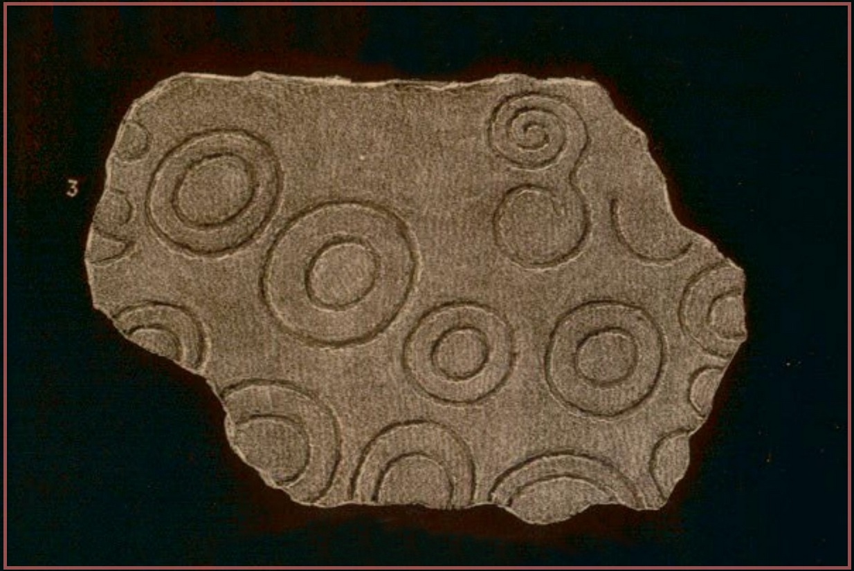
The carving here was first mentioned by one of the great petroglyphic pioneers James Simpson (1866; 1867):
“A broken slab, about two feet square, covered with very rude double rings and a spiral circle, was found by Mr Mackintosh, at La Mancha, in Peeblesshire, in digging in a bank of gravel. There were some other large stones near it; none of them marked. Possibly this stone, therefore, is sepulchral in its character.”
Lamancha carving (G. & A. Ritchie, 1972 )
Eoin MacWhite (1946) was somewhat sceptical of Simpson’s “sepulchral” association, simply due to there being no account of a burial here. But in Simpson & Thawley’s (1972) survey of passage grave art, they thought the Lamancha carving was from “a possible cist slab.” We might never know for sure one way or the other.
The carving ended up living in Edinburgh’s National Museum where it should, hopefully, still be on display. As a result of this, it received the attention of the Royal Commission doods who gave a good description of the design in their Peeblesshire Inventory (1967). They state that it
“is irregular in shape and has maximum dimensions of 2ft 6in by 1ft 10in; it averages 4in in thickness. The markings, which have all been formed by the pecking technique, occur mainly on one face, the most common symbol being single or double rings. There are four complete double-ring symbols, in which the outer rings measure from 5in to 7in in diameter, and the inner rings from 2in to 4in. Round the margin of the face there are the broken arcs of five more double-ring symbols and of five single rings and one small V -shaped figure. As well as the ring markings there is a double-spiral, each lobe of which measures about 4in in diameter. In one lobe the spiral has two and a half turns and in the other only one turn. In addition, in a space which is otherwise free of markings, there is an area, about 4in square, heavily pitted with punch-marks measuring one-eighth of an inch across and one-sixteenth of an inch in depth. A remarkable feature of the stone is that three incomplete single ring symbols have been made on one edge. They have been formed by the same technique and measure 3in across; as in all the other symbols, the grooves themselves measure about half an inch in width and about one-eighth of an inch in depth.”
McWhite, Eoin, 1946 “A New View on Irish Bronze Age Rock-Scriblings”, in Journal Royal Society Antiquaries, Ireland, vol. 76, 1946.
Morris, Ronald W.B., “The Cup-and-Ring Marks and Similar Sculptures of South-West Scotland,” in Transactions of the Ancient Monuments Society, volume 14, 1967.
Morris, Ronald W.B., “The Cup-and-Ring and Similar Early Sculptures of Scotland; Part 2 – The Rest of Scotland except Kintyre,” in Transactions of the Ancient Monuments Society, volume 16, 1969.
Morris, Ronald W.B., The Prehistoric Rock Art of Southern Scotland, BAR: Oxford 1981.
Ritchie, Graham & Anna, Edinburgh and South-East Scotland, Heinnemann: London 1972.
Royal Commission on the Ancient & Historical Monuments, Scotland, Peeblesshire – volume 1, Aberdeen University Press 1967.
Simpson, D.D.A. & Thawley, J.E., “Single Grave Art in Britain,” in Scottish Archaeological Forum, no.4, 1972.
Simpson, J.Y., “On Ancient Sculpturings of Cups and Concentric Rings,” in Proceedings of the Society of Antiquaries, Scotland, volume 6, 1866.
Simpson, James, Archaic Sculpturings of Cups, Circles, etc., Upon Stones and Rocks in Scotland, England and other Countries, Edmonston & Douglas: Edinburgh 1867.
Cup-and-Ring Stone (removed): OS Grid Reference – NT 1872 4072
Archaeology & History
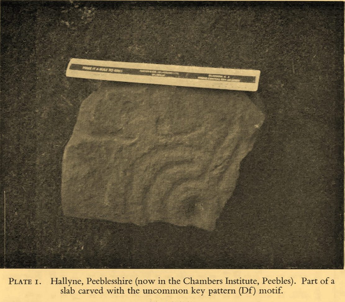
Included in the standard catalogues by Ronald Morris (1967; 1969), this carving was brought to light fortuitously by the local farmer who, thankfully, recognized its archaeological importance. Etched into a small flat broken block of stone, he noticed a cup-marking and the remains of a triple-ring around it, with grooves running out from the central cup. It was described in detail by the Royal Commission (1967) lads in their county survey where they told:
R.W.B. Morris’ 1967 photoHallyne carving in Peebles Museum
“During the excavations at the Roman fort at Lyne…in June 1959, a stone bearing cup-and-ring markings was found lying beside the fence that crosses the North Annexe. According to local information it was found while ploughing in the field on the NE side of the fence. It is a sandstone block, measuring 1ft 5in by one foot, and with an average thickness of 8in. It is clearly a mere fragment of what must have been a larger slab, but it is impossible to estimate its original dimensions. The markings consist of a single well-formed cup, 2in in diameter and three-quarters of an inch in depth, now partly surrounded by the broken arcs of three rings, which, if complete, would measures about 4in, 7in and 10in in diameter respectively. The rings are all half an inch in width and one eighth of an inch in depth. From the innermost ring two radial grooves, set one inch apart, extend outwards for a maximum distance of 4in. They interrupt the two outer rings, which stop short on either side of them, leaving a gap of about half an inch. The grooves are slightly narrower and shallower than the rings. The whole symbol has been formed by the pecking technique and punchmarks are still remarkably fresh. Outside the outermost ring there is a very shallow depression, one inch in diameter, which may be another cup-mark; in addition there are several recent scars caused by the plough.”
It was moved to the museum in Peebles shortly after being found and remains there to this day, apparently. I’ve not seen it.
References:
Morris, Ronald W.B., “The Cup-and-Ring Marks and Similar Sculptures of South-West Scotland,” in Transactions of the Ancient Monuments Society, volume 14, 1967.
Morris, Ronald W.B., “The Cup-and-Ring and Similar Early Sculptures of Scotland; Part 2 – The Rest of Scotland except Kintyre,” in Transactions of the Ancient Monuments Society, volume 16, 1969.
Morris, Ronald W.B., The Prehistoric Rock Art of Southern Scotland, BAR: Oxford 1981.
Royal Commission on the Ancient & Historical Monuments of Scotland, Peeblesshire – volume 1, HMSO: Edinburgh 1967.
Cup-Marked Stone (lost): OS Grid Reference – NT 179 356
Archaeology & History
In Sir George Douglas’ (1899) brief sketch of prehistoric remains in Peeeblesshire, he described coming across a petroglyph somewhere near the top of the Iron Age hillfort east of Stobo Castle, near Drumelzier (King Arthur country). He told that,
“on a flat stone lying on the slope of the fort at Lour, are two “cups,” measuring 2¾ inches in diameter and an inch in depth, and exhibiting perfect symmetry in their form and position on the stone: they have been thought to be genuine examples of “rock-markings”.”
The carving hasn’t been seen since and it’s presumed that vegetation has covered the stone. (the grid-reference for this site is an approximation)
Cup-and-Ring Stone (lost): OS Grid Reference – NT 269 419
Also Known as:
Kittlegairy Burn
Archaeology & History
Fred Coles’ 1898 sketch
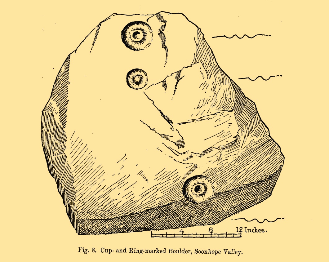
An apparently isolated cup-and-ring stone was found on the hills north of Peebles at the end of the 19th century by the renowned Scottish megalith explorer, Fred Coles. (1899) He was having a look at some of the hillforts in the area and—as some of us tend to do—he began meandering off-track, down streams, through bogs and as a result came across the carving that’s illustrated here. It’s subsequently become “lost” in the hills, but it shouldn’t be too difficult to locate, as the description he gave of its whereabouts is a pretty good one. He told us:
“A very little over one mile and a quarter up the valley, measuring from the road at Kerfield Cottage, a tiny rivulet called Kittlegairy Burn trickles down from the SE into the main stream. On the hill to its east, and about 450 feet higher, are the remains of a fort, one of a series of three crowning prominent heights along this side of the valley. Down the main stream from Kittlegairy Burn is a large ruined sheep-shelter called Soonhope. Nearly midway between these two points a deep curve has been hollowed out of the E. bank; and, at the foot of this rather high gravel bank, half immersed in the stream, lies the block of stone with the cup-and ring-marks. They were discovered, 14th September 1896, by my daughter, Helen, on crossing the stream; and we at once proceeded to make a measured drawing, a reproduction of which is given here…. The depth of the rings in proportion to their width is the one most noticeable feature; next, the extreme thinness of the intervening ‘neck’; but, on a minute and careful examination of the nature of the stone itself, taking into consideration that its angularity and sharpness of edge and the absence of moss or even of confervoid growths on its surfaces went against the possibility of its being truly waterworn.”
The rock had obviously fallen from its original position above the burn. Today, the entire area where this stone exists has been covered by a huge forestry plantation, but if any rock art fanatics from the Peebles area get bored one day and have nothing to do…..
References:
Coles, Fred, “Notices of the Discovery of a Cist and Urns at Juniper Green, and of a Cist at the Cunninghar, Tillicoultry, and of some Undescribed Cup-marked Stones’, in Proceedings Society Antiquaries, Scotland, volume 33, 1899.
Morris, Ronald W.B., “The Cup-and-Ring and Similar Early Sculptures of Scotland; Part 2 – The Rest of Scotland except Kintyre,” in Transactions of the Ancient Monuments Society, volume 16, 1969.
Cup-and-Ring Stone (removed): OS Grid Reference – NT 807 659
Archaeology & History
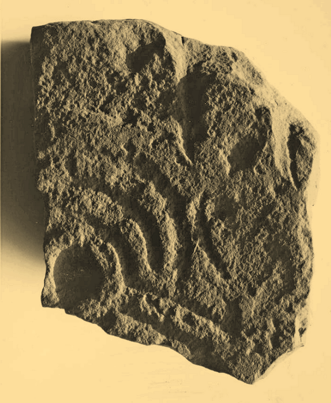
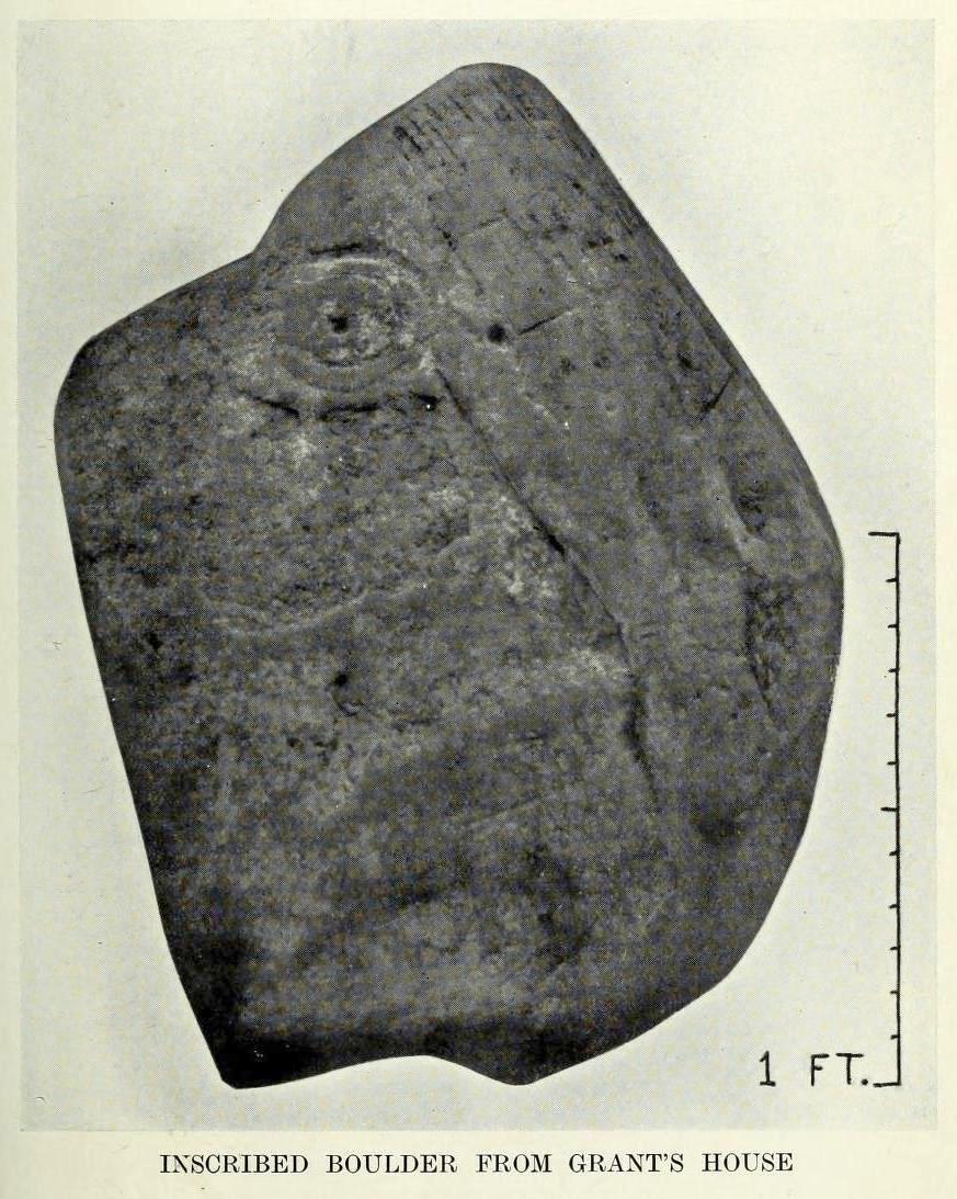
A carving that no longer exists in its place of origin, but can now be seen in the National Museum of Antiquities in Edinburgh. It was discovered by a Mr James Craw (1931), who gave us the following account of his find:
“In 1910 my attention was attracted by some markings on a boulder on the top of a field wall, ¼-mile NNW of Grant’s House church and at an elevation of some 550 feet above sea level. The stone was a rounded and somewhat flattened slab of greenstone, measuring 22 inches by 17 inches by 4 inches… It bore a small cup ½-inch in diameter, surrounded by two rings of shallow incision, the outer being 3 inches in diameter. From the cup a duct, partly natural, led across the stone, and another cup, without rings, had also a short duct. Adjacent to these markings was a curious grid design of shallow lines, a series of parallel lines ¼-inch apart, being crossed at right angles by lines 2½ inches apart.”
1930 photo of the carving
Across a section of the stone there may also be a curving pecked line which Craw didn’t appear to notice. The parallel lines would appear to have quite separate origins, with those running below the cup-and-ring seeming to be ancient, whereas the others have the appearance of being cut with metal tools and seem much more like modern scarring.
Shortly after finding the stone, Mr Craw took the petroglyph to the National Museum in Edinburgh, where he was told that they didn’t think it “as being of early workmanship, the cups and rings being of much smaller proportions than the typical markings of the Bronze Age and the grid design having no known parallel.” They were wrong on both accounts of course, although I for one still remained unconvinced by one set of parallel lines that run along to the edge of the stone. That said, there are similar carvings of parallel lines at the impressive Traprain Law 15 miles northwest of here, so I may be wrong.
The wall in which this carving was found was obviously not its place of origin. It most likely came from one of the cairns that was reported by J. Hardy to have been destroyed in this field in 1882.
References:
Craw, James H., “An Inscribed Boulder from Grants House,” in History of Berwickshire Naturalists Club, volume 27, 1931.
Edwards, Arthur J.H., “Rock Sculpturings on Traprain Law,” in Proceedings Society of Antiquaries, Scotland, volume 69, 1935.
Morris, Ronald W.B., “The Cup-and-Ring and Similar Early Sculptures of Scotland; Part 2 – The Rest of Scotland except Kintyre,” in Transactions of the Ancient Monuments Society, volume 16, 1969.
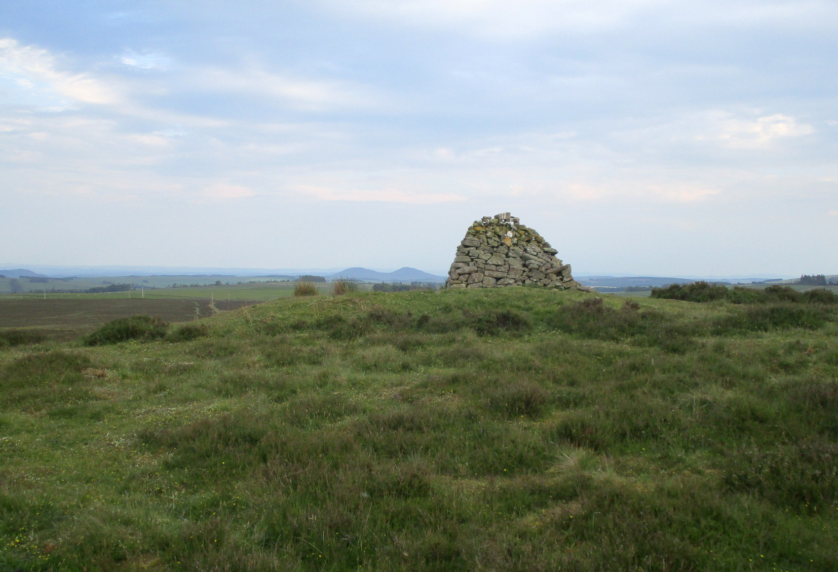
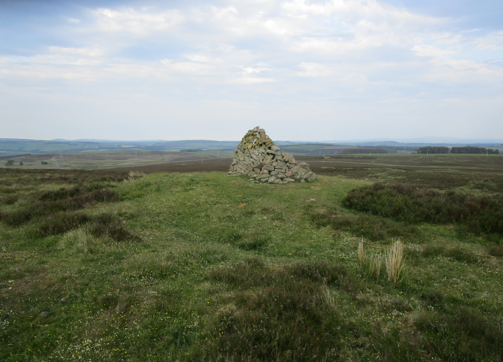
Take the B6362 high road between Lauder and Stow and, regardless of which direction you’re coming from, when you reach the top heights of the moorland road with views all around, you need to keep your eyes peeled for where a dirt-track runs south and, diagonally across the road on its north side, is a dirt-track-cum-parking-spot (if you came from Stow, you should’ve already noticed the cairn on the skyline on your way up). There’s a hut circle in the heather by the parking spot. From here, just walk over the heather nearly 300 yards north. Y’ can’t really miss it.
Archaeology & History
Looking to the southeast
The first thing that you see as you approach here is a modern cairn which is sat upon the more ancient and completely overgrown one. You can’t really see the “ancient” section of it until you walk round to its more northern side, where you’ll then notice how the new cairn has been built on top of a small but artificial rise in the ground, about ten yards across. This is the original ancient cairn. Sections of the ground have come away on its southern side, revealing a scattered mass of loose stones. It doesn’t seem to have been excavated but has all the hallmarks of being typically Bronze Age by the look of it. Of particular note is the superb view from here, not least towards the legendary Fairyland of the Eildon Hills, standing out clearly about 10 miles to the south…
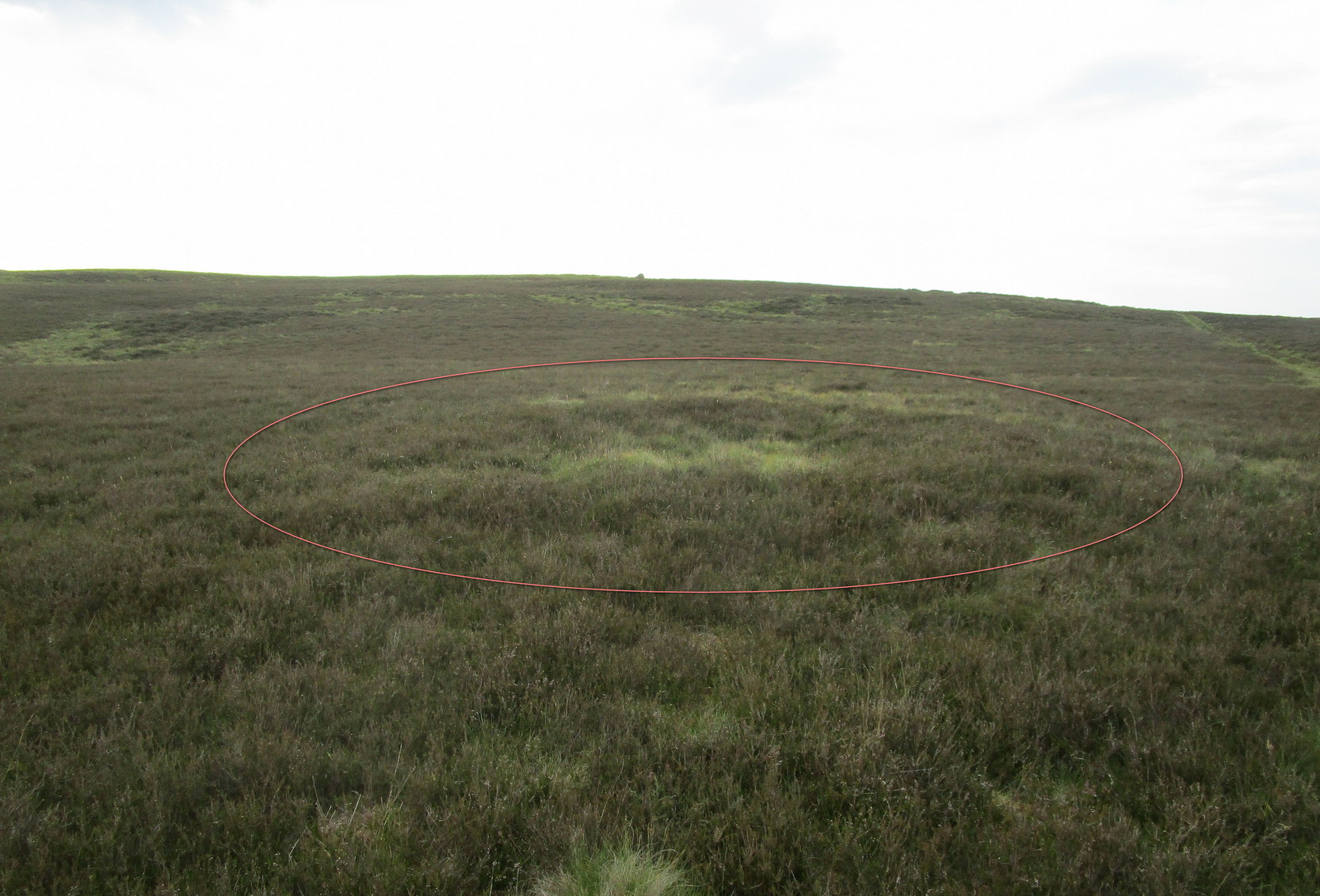
Take the B6362 high road between Lauder and Stow and, regardless of which direction you’re coming from, when you reach the top heights of the moorland road with views all around, you need to keep your eyes peeled for where a dirt-track runs south and, diagonally across the road on its north side, is a dirt-track-cum-parking-spot. Park up here and walk 10 yards or so into the heather on your left. You’re probably stood at the side of it!
Archaeology & History
Hut circle (ringed) looking N
A very distinct, but isolated hut circle can be seen here when the heather is short. It’s most notable by seeing the slightly elevated circular rise in the ground with the rough ring of long grasses in the middle of it. To be honest, unless you’re a mad archaeo-geek into these sort of things, it’s not gonna send a rush of blood to your head.
Probably constructed in the Bronze Age, it’s a plain little thing about six yards across, making it suitable for perhaps just a couple of folk to have lived in. The overgrown walling is very low (between 12-18 inches high) and about a yard wide all the way round it. The main thing that you’ll get from this place is not only the sense of isolation, but the beautiful view…
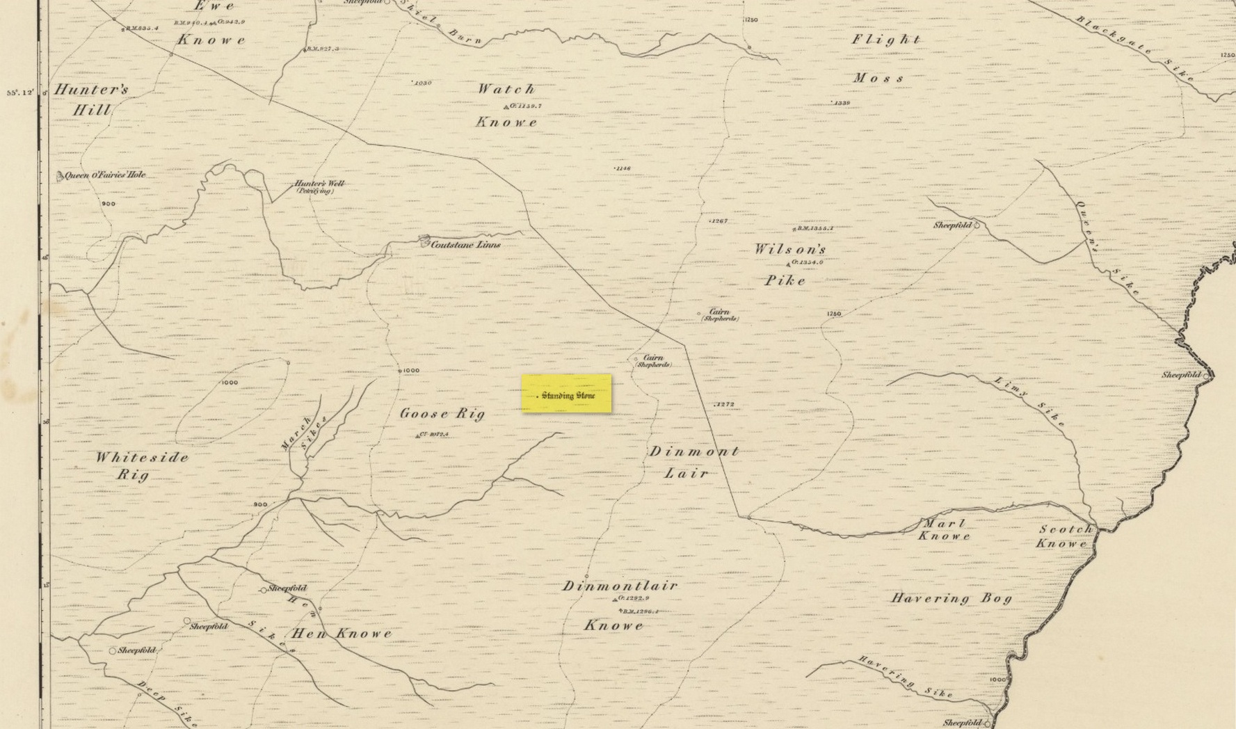
Standing Stone (destroyed): OS Grid Reference – NY 546 889
Archaeology & History
Stone shown on 1863 map
Once found living on the high moors four miles to the east of Newcastleton, close to the English border, all trace of the stone has gone. Highlighted on the 1863 OS-map, the stone was three feet high and was located at the highest end of Goose Rig. It was deemed by local people “to be of ancient origin,” but we know little else about it. A place immediately to the northwest is known as the Queen o’ Fairies Hole, whose history and folklore has also been forgotten…
References:
Royal Commission on the Ancient & Historical Monuments of Scotland, Roxburghshire – volume 1, HMSO: Edinburgh 1956, p.95
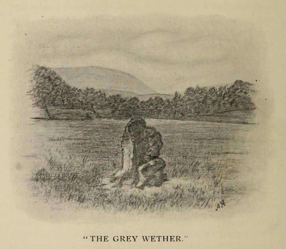
This is a site that requires the attention of some local antiquarians, as there are conflicting reports as to whether or not it still lives in its old haunt. Very little has been written about it and its whereabouts seems to have been completely missed in the radars of all megalithic guides. The Langholm historians—John and Robert Hyslop (1912)—who wrote about the place in their gigantic history work more than a hundred years ago, would no doubt be shaking their heads at such lackings.
They told:
“The best example of the standing stones in the Eskdale district is that at Meikledale in Ewes, locally known as ” The Grey Wether,” a print of which is here given. It is about 5 feet in height and its girth is 8 feet 7 inches, and it would probably weigh about two tons. The stone is the common greywacke, or whinstone of the Silurian series, rough and unhewn. It stands in the centre of a field in front of Meikledale House, and can be seen from the highway. The field is surrounded by hills on every side,”
which the writers thought might have been the reason for its erection here, although having more to do with the natural beauty of the landscape than any archaeocentric or geomantic factor.
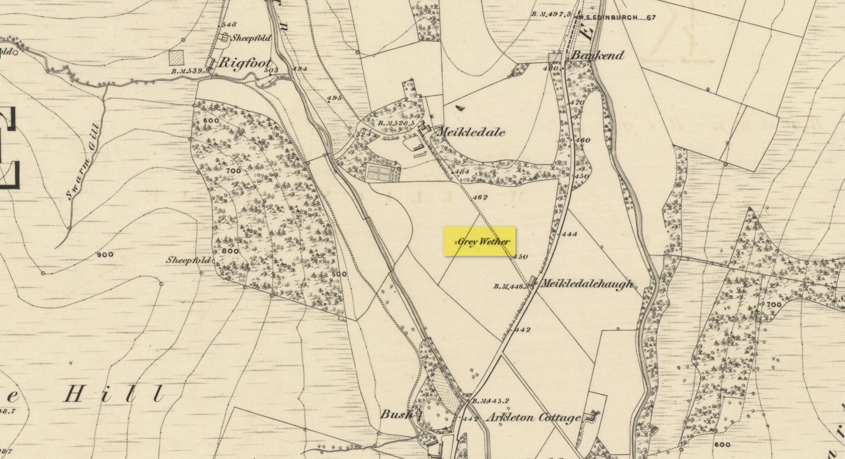
Shortly after this had been written, Alexander Curle of the Royal Commission visited the area and made note of this “standing stone known as the Grey Wether…situated on the haughland some 250 yds SSE of Meikledale”, but added nothing more. It was several years later before a Royal Commission (1920) team came here and told that,
“A standing-stone, known as the “Grey Wether,” is situated on the haugh-land, some 250 yards south-south-east of Meikledale. It is a large whinstone slab, measuring in greatest height 4 feet 8 inches, in breadth 3 feet 5 inches, and in thickness 1 foot, and faces west-south-west and east-north-east.”
Stone shown on 1857 map
But they subsequently reported that, prior to World War 2, some complete dickhead knocked it down, broke it up and dumped it in a nearby stream! However, in 1980 some more lads from the Scottish Royal Commission revisited the area and alleged that a stone laid in the field 250 yards below of Meikledale farmhouse was our old Grey Wether. The position they describe is the same spot as the one shown on the 1857 OS-map; and at this very spot on GoogleEarth it seems that a stone there lies… Are there are any local folk in that neck o’ the woods who could find out…?
Folklore
The Greywethers stone circle on Dartmoor has a veritable mass of folklore attached to it, but its namesake here at Langholm has very little. The origin of its name has been forgotten. All we have left is what the Ordnance Name Book in 1857 recorded, telling that “it is supposed to have been erected in memory of some Hero, but no further account of it can be obtained.”