Cup-and-Ring Stone (lost): OS Grid Reference – NY 3851 8149
Archaeology & History
A petroglyph that was rediscovered as recently as 2003, by J. Ward, has, it would seem, already been lost. In all likelihood it has become hidden beneath vegetation. Found near the Petrifying Well, the carving is archetypal, consisting of a single cup surrounded by two rings, on a low flat piece of rock on the south-side of the Tarras burn, only a few hundred yards above the road. I’ve added the site here in the hope that a diligent petroglyph hunter can find it again and leave it open to the elements for us all to see. Let us know if you find it.
This is a site that requires the attention of some local antiquarians, as there are conflicting reports as to whether or not it still lives in its old haunt. Very little has been written about it and its whereabouts seems to have been completely missed in the radars of all megalithic guides. The Langholm historians—John and Robert Hyslop (1912)—who wrote about the place in their gigantic history work more than a hundred years ago, would no doubt be shaking their heads at such lackings.
They told:
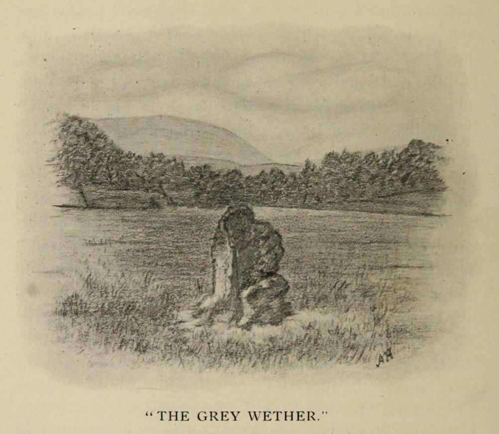
“The best example of the standing stones in the Eskdale district is that at Meikledale in Ewes, locally known as ” The Grey Wether,” a print of which is here given. It is about 5 feet in height and its girth is 8 feet 7 inches, and it would probably weigh about two tons. The stone is the common greywacke, or whinstone of the Silurian series, rough and unhewn. It stands in the centre of a field in front of Meikledale House, and can be seen from the highway. The field is surrounded by hills on every side,”
which the writers thought might have been the reason for its erection here, although having more to do with the natural beauty of the landscape than any archaeocentric or geomantic factor.
Shortly after this had been written, Alexander Curle of the Royal Commission visited the area and made note of this “standing stone known as the Grey Wether…situated on the haughland some 250 yds SSE of Meikledale”, but added nothing more. It was several years later before a Royal Commission (1920) team came here and told that,
“A standing-stone, known as the “Grey Wether,” is situated on the haugh-land, some 250 yards south-south-east of Meikledale. It is a large whinstone slab, measuring in greatest height 4 feet 8 inches, in breadth 3 feet 5 inches, and in thickness 1 foot, and faces west-south-west and east-north-east.”
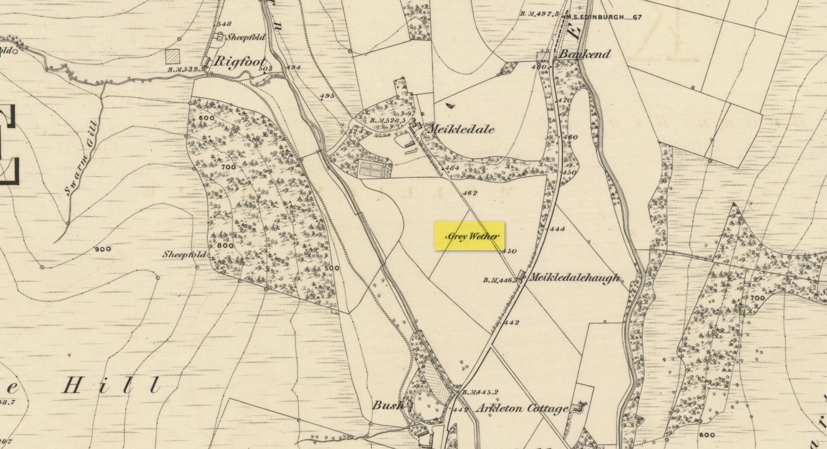
Stone shown on 1857 map
But they subsequently reported that, prior to World War 2, some complete dickhead knocked it down, broke it up and dumped it in a nearby stream! However, in 1980 some more lads from the Scottish Royal Commission revisited the area and alleged that a stone laid in the field 250 yards below of Meikledale farmhouse was our old Grey Wether. The position they describe is the same spot as the one shown on the 1857 OS-map; and at this very spot on GoogleEarth it seems that a stone there lies… Are there are any local folk in that neck o’ the woods who could find out…?
Folklore
The Greywethers stone circle on Dartmoor has a veritable mass of folklore attached to it, but its namesake here at Langholm has very little. The origin of its name has been forgotten. All we have left is what the Ordnance Name Book in 1857 recorded, telling that “it is supposed to have been erected in memory of some Hero, but no further account of it can be obtained.”
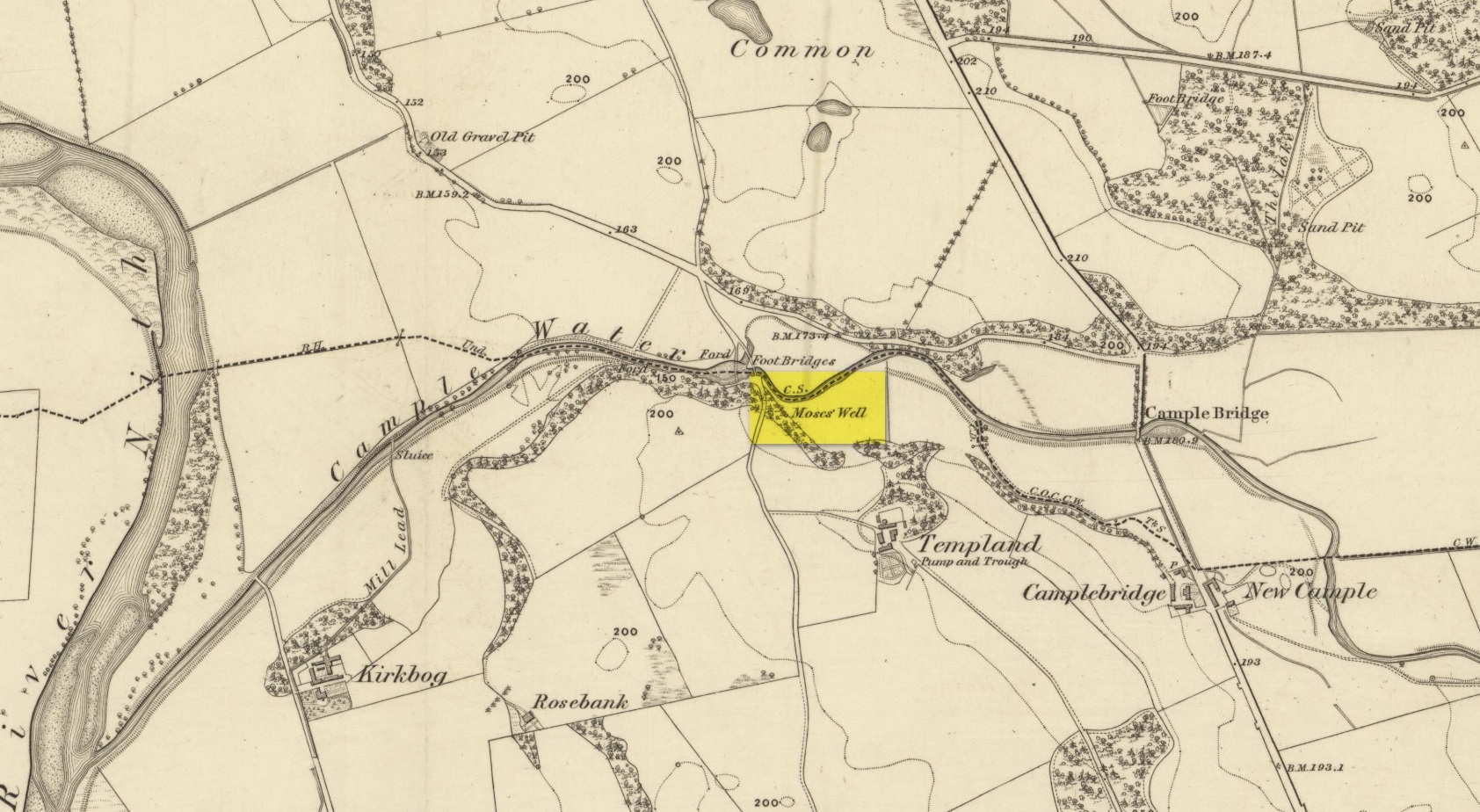
This little-known Biblical-sounding spring has apparently long since fallen back to Earth (perhaps there might be some local folk who could find out for certain). Shown on the 1861 Ordnance Survey map as being at the side of the wall in the small copse of trees—immediately east of kirk- place-names and a half-mile north of St Ninian’s Well—it was briefly described by T.C. Ramage (1876), who seemed to know nothing of its lore, merely telling us that,
“on Templand farm, close to the wooden bridge over the Cample, there is Moses’ Well, an unusual designation, but which some Knight Templar may have given in remembrance of his toils in Palestine.”
The Templar designation was deemed by Ramage to come from the name of the farm. However, a few years prior to this, the early Scottish place-name surveyors were traversing the area and found from local people how it derived “its name from a Tinker named Moses Marshall who with his family lived near it in a Camp during the time they had the small pox.” The Well was also included in the Morris survey (1982), but without comment. Another Moses Well can be found 44½ miles to the northeast, near Galashiels at NT 4046 4306.
From the hamlet of Eskdalemuir, take the B709 road over the river bridge and keep going for about a mile, past the Hartmanor Hotel. Keep your eyes peeled for the small parking spot on the left-hand side of the road soon after the hotel. Once here, cross the road and walk down the footpath towards the river, following the line of the fence, pass the superb apple trees. You’ll walk straight to it!
Archaeology & History
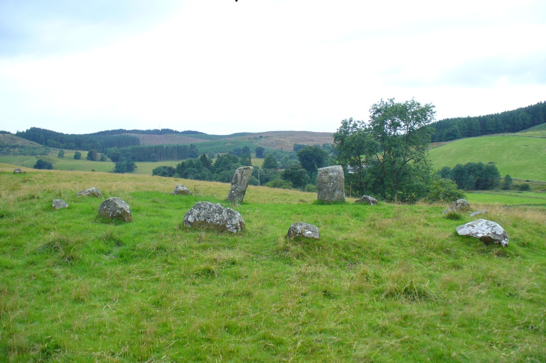
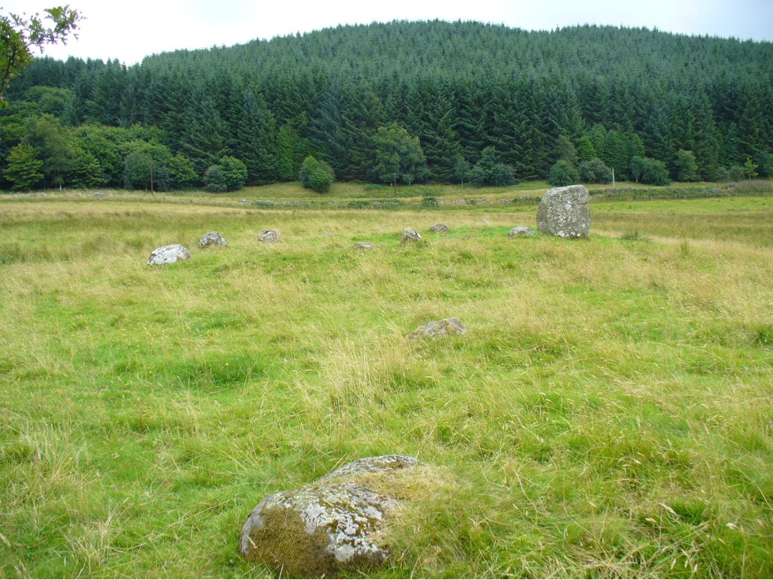
The Loupin Stanes, looking SW
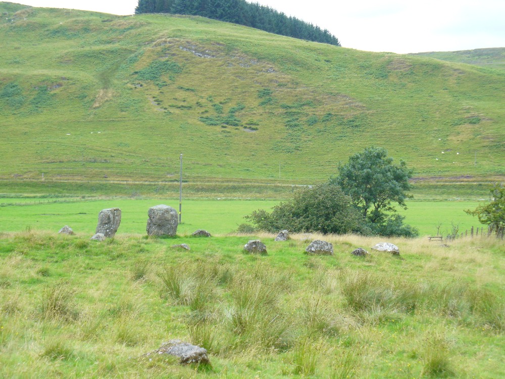
A long distance from anywhere out here in the hills, my short foray here with fellow antiquarian Paul Hornby told that there was once much more here than presently meets the eye. Aubrey Burl (1979) hinted at the same, as did our mathematical megalithic magus Alexander Thom. (1980) There are curious stones near and not-so-near the circle you’re about to meet, many of them speaking of relationships just hiding beneath their historical surface. Sadly we only spent a short time here at the Loupin Stanes. A full day or two would have been much better!
Despite this circle (and its nearby companion the Girdle Stanes) hiding miles away from anywhere out here, the legendary compilers of the 18th century Statistical Account of Scotland still managed to find it, telling us simply,
“On the farm of Coatt there are two circles of erect stones, the one entire measuring about 90 feet (i.e., in girth), and the other, having a part of it worn away by the Esk, measuring about 340 feet.”
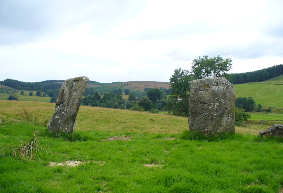
The ‘entrance stones’Loupin Stanes, looking WNW
Another century was to pass by before anyone else came and wrote about these hidden stones, sitting upon a level man-made platform built by neolithic or Bronze Age ancestors. In Dave Christison’s (1897) lengthy article for the Scottish Society of Antiquaries, he gave a pretty lengthy description of the Loupin Stanes, which is still as accurate today as when he wrote it 120 years ago. He told:
“The site of the smaller circle is at Hartmanor, retired about 80 yards from the river, in a gently undulating field, and it has been banked up nearly all round from a foot to 18 inches, perhaps with the object of making the interior level. The circle consists of thirteen stones…not reckoning one which seems too small to be included, but from the inequality of the intervals it is likely that a number have been carried off, and this seems proved by one hollow…left in all probability by the removal of a stone, and – by another within the circle opposite a blank in it, probably caused by digging to uproot a second stone. The developed view…shows this irregularity of the spacing. But it also shows that two neighbouring stones greatly exceed the others in size, and alone can be considered truly standing, as they are pillar-like and set on end, whereas the smaller ones are so shaped that it does not much matter on which end they are placed. The two large stones are about 5 feet 4 inches high, and are flat-topped. One is a massive rectangular block, about twice the bulk of the other. Few of the smaller stones stand a foot above ground, and the two highest do not exceed a couple of feet. The large stones (in this ring) are known as ‘the loupin’ stanes…
“…In its present state the ‘circle’ is slightly oval, the cross diameters, measured from the inner faces of the stones, being about 35 and 31 feet. The entrance, if we may call it so, between the two pillar-stones, looks out about E.S.E.”
Of course, Christison meant WSW, not ESE. Probably the best description of the Loupin Stanes (and the nearby Girdle Stanes) was done, not surprisingly, by a local historian. In the superb work on the Langholm district, the brothers Hyslop (1912) gave commendable descriptions—including ingredients which, I’m pleased to say, the likes of Mr Hornby and myself wondered over in our short visit here. Burl and Thom thankfully noted the very same elements.
Loupin Stanes & stone avenue to the Girdle Stanes
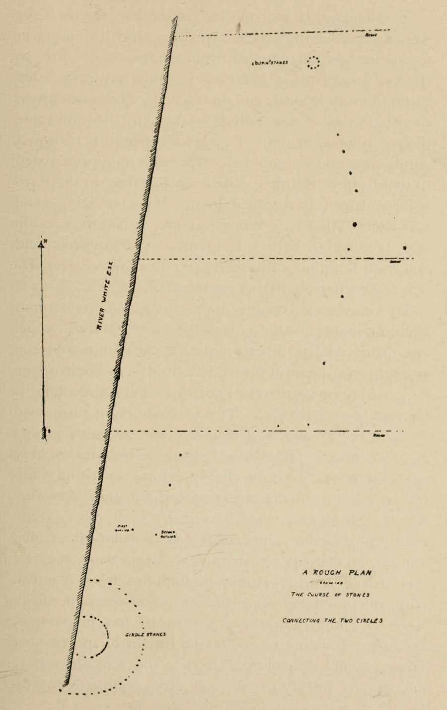
The casual visitor here cannot fail to note the curious scatter of other stones close to this megalithic ring. Before you actually reach the circle there is a scatter of small stones which have more of a ‘feel’ to them being related to the actual circle than proof has yet afforded. Both Thom and Burl postulate this scatter of stones as the remains of another damaged stone circle. One of these stones has three cup-marks upon it. But there are other stones reaching away up the slope of the field to the south. Our impression here was that these had some relevance to the circle when it was first built, probably 4000 years ago. Paul suggested the idea of an ‘avenue’ perhaps linking it with the Girdle Stanes circle about 600 yards away. He wasn’t the first to do so. John and Robert Hyslop (1912) talk of the likely relationship these two stone circles had with each, and much more:
“Though now forming separate circles 600 yards apart, that they were at one time, though possibly not originally, parts of one scheme is clearly indicated by their relative positions and especially by the irregular line of large stones stretching from one to the other. Only two of the stones of the first Circle are now standing. One stands 4 feet 9 inches above ground and measures 19 feet 5 inches in girth. The other is also 4 feet 9 inches high but is only 7 feet 8 inches in girth. It is quite possible that some of the other stones composing the Circle are in their original positions, though they are now greatly weathered and broken… This…Circle when built appears to have consisted of nine* large stones, and was nearly 36 feet in diameter, or some 113 feet in circumference by inside measurement.
“A little to the south-east of the Loupin’ Stanes there is what, to the casual observer, appears to have been, and probably was, another Circle also of nine stones, with a centre stone. Some of these stones have been displaced, and the contour of the Circle is consequently broken. Nearer the Esk, and almost touching the Loupin’ Stanes, are four single stones whose relation to the other members of the group it is very difficult even to guess. Fancy or guesswork might weave a simple theory which could neither be proved nor absolutely refuted — but it is wiser not to guess in questions like this! Reference has already been made to the “avenue,” or line of single stones stretching from the Loupin’ Stanes to the Girdle Stanes. Though the line is not a straight one, and is broken, it seems to afford fairly conclusive proof that all these stones at the Cote are parts of what must once have been a prehistoric monument of considerable importance, and, needless to add, of great antiquity.”
The ‘avenue’ between the two circles was later described with a bit more detail and the suggestion of an astronomical function arose. Again, the Hyslop’s (1912) told that the avenue was,
“a course of 11 stones placed at intervals between the two Circles, rudely joining them, but not in a straight line. The last four of these (nearest the Loupin’ Stanes) form very nearly a straight line in a direction S. 16 34′ E., but no satisfactory significance has been found for this line.
“…Whether there was a single or double line of stones in the “avenue” between these two Circles cannot be said until a careful survey has been made. The theodolite and the link-chain have a curious habit of settling these disputed points and spoiling many a charming theory — without regrets or apologies! But this much may safely be said: if an “avenue” existed between the Loupin’ Stanes and the Girdle Stanes, as appearances suggest, it was probably for ceremonial rather than for astronomical purposes.”
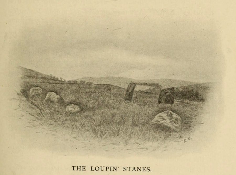
Remains of possible avenue, from the Esk to the StanesHyslop’s old drawing of the Loupin Stanes
Very true indeed. But whether this alignment of weaving stones has actual relevance to the megalithic arena, only detailed excavations will tell for sure. Yet on the western side of the Loupin Stanes, we see at least four stones (possibly six) which run down to the River Esk. This also may be remains of an old avenue, taking us to an important water source.
No ‘avenues’ were mentioned in the survey by the Royal Commission (1920) lads, written several years after their visit here in July 1912. They described the site as follows:
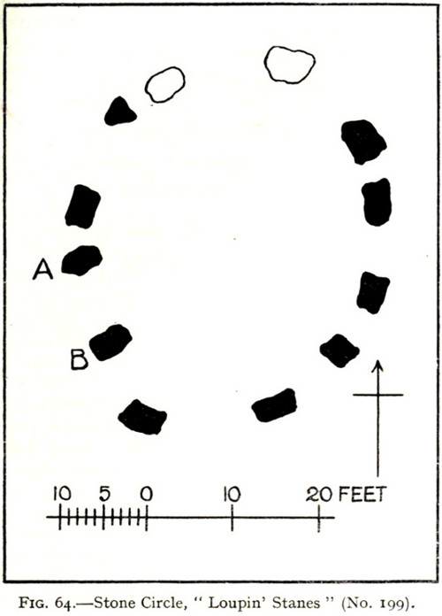
“The stone circle known as the Loupin Stanes…is situated at an elevation of 600 feet above sea-level, on an undulating meadow some 80 yards from the left bank of the White Esk and 600 yards north-east “of the Girdle Stanescircle…. It consists of twelve stones placed at irregular intervals, of which, on the west side, only two, standing 8 feet apart (A and B on plan, fig. 64), are true pillars, all the others being simply boulders.
“The setting does not form a true circle but is flattened on the western arc; it measures some 38 feet in diameter from north to south and 31 feet from east to west. The pillar stones, which are flat-topped, measure about 5 feet 4 inches in height, and the two highest of the smaller stones do not exceed 2 feet, while few of them reach 1 foot. The site has been banked up nearly all round from 1 foot to 1 foot 6 inches, perhaps with the object of making the interior level. There are numerous large stones adjacent, some of which may be the remains of other circles, but others are probably merely boulders naturally deposited or outcrop of rock. The field was in a hay crop at the date of visit, and the fallen stones were not easily seen.”
1920 Loupin Stanes plan (after RCAHMS )
When Alexander Thom (1980) came here and measured the site, he thought there was a ‘possible’ midsummer sunrise from the stones—but even he didn’t seem convinced. Described as a Type A Flattened Circle, he did find units of his ‘megalithic yard’ in the construction of the site.
Folklore
In David Christison’s essay (1897) on this and its companion site—the Girdle Stanes—he told:
“The large stones are known as ‘the loupin’ stanes,’ because it is said that lads, and even a lass, were in the habit of jumping from the top of one to the other; but as the distance is 8 feet, the people of the district must be uncommonly good ‘loupers’ to accomplish the feat without breaking their legs. However it may be with their limbs, so little are the powers of observation of the natives cultivated that, although all know ‘the loupin’ stanes,’ they generally deny the existence of a circle.”
This narrative was repeated in the Hyslop’s (1912) work. Though it should be noted here that Mr Christison’s final remark about the local people denying the existence of any such circle is something I’ve encountered a few times, despite them knowing otherwise. But for good reason, it has to be said.
…to be continued…
References:
Burl, Aubrey, Rings of Stone, Frances Lincoln: London 1979.
Burl, Aubrey, A Guide to the Stone Circles of Britain, Ireland and Brittany, New Haven & London 1995.
Burl, Aubrey, The Stone Circles of Britain, Ireland and Brittany, Yale University Press 2000.
Christison, David, “‘The Girdlestanes’ and a neighbouring stone circle, in the parish of Eskdalemuir, Dumfriesshire”, in Proceedings of the Society of Antiquaries, Scotland, volume 31, 1897.
Hyslop, John & Robert, Langholm As it Was, Hills & Company: Sunderland 1912.
Macauley, Anne, Megalithic Measures and Rhythms, Floris: Edinburgh 2006.
Royal Commission on the Ancient & Historical Monuments, Scotland, Inventory of Monuments and Constructions in the County of Dumfries, HMSO: Edinburgh 1920.
Thom, Alexander, Megalithic Sites in Britain, Oxford University Press 1967.
Thom, A., Thom, A.S. & Burl, H.A.W., Megalithic Rings, BAR: Oxford 1980.
From junction 16 on the A74(M) turn off an go up the B7076 road, roughly parallel with the motorway, for about 2 miles, turning right – over the A74(M) – until you hit the T-junction by the lovely hamlet of Newton. At the T-junction turn right again and along down the road for just 300 yards or so. You’ll see the small Skip Cottage, almost overgrown by the tiny roadside on your right. Stop here and look into the field across the road. It’s right in front of you!
Archaeology & History
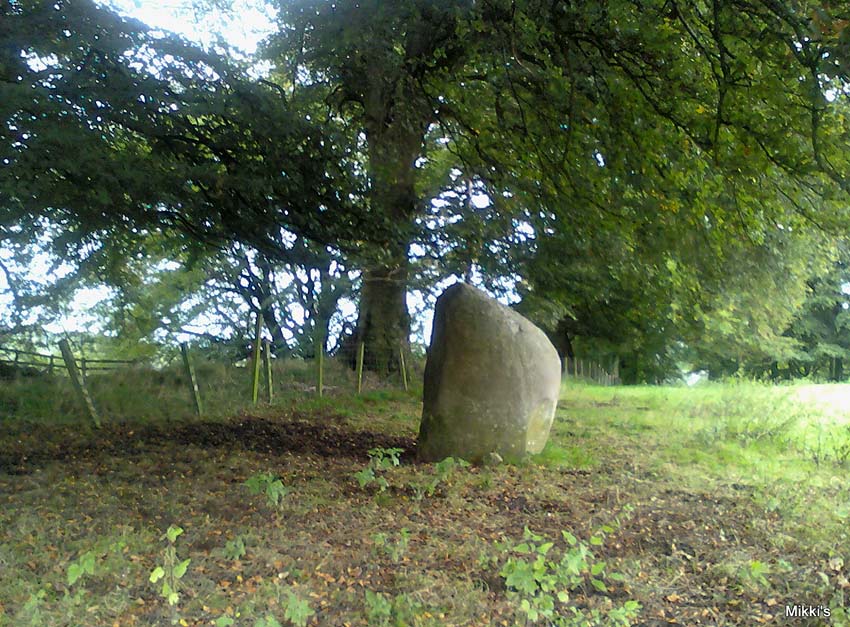
Looking SW
Despite the size and almost romantic setting of this large standing stone, I can find little by way of early descriptions or archaeological reports here. Nearly six feet tall with its long axis aligned east-west and in seeming isolation, I find it hard to believe that we have no other sites or relevant data here. Echoing the work by Alexander Thom (1990:2), Aubrey Burl (1993) makes mention of it as one in a possible “pair” of standing stones, with its companion being “18ft (5.5m) away…in roadside bank,” but this is debatable. This second stone seems as much a part of the old walling. On purely subjective grounds, it gave the impression of once playing a part in a stone circle — an opinion also held by the Scottish Royal Commission (1920) lads after their visit here in August, 1912. Does anyone know anything more about this place?
References:
Burl, Aubrey, From Carnac to Callanish, Yale University Press 1993.
Royal Commission on Ancient & Historical Monuments, Scotland, Inventory of Monuments and Constructions in the County of Dumfries, HMSO: Edinburgh 1920.
Thom, A., Thom, A.S. & Burl, Aubrey, Stone Rows and Standing Stones – volume 2, BAR 560: Oxford 1990.