Healing Well (destroyed): OS Grid Reference – NT 314 735
Archaeology & History
This was one of two medicinal springs that could once be found in old Portobello village. Like its companion Chalybeate Well nearly a mile northwest, in the early 19th century those entrepreneurial types tried fashioning these waters into being a Spa Well. It didn’t really work and the fad passed after just a couple of decades—and soon after the local people had completely lost their water supply here. The best historical account of it is in William Baird’s (1898) magnum opus on Portobello. He told how the well,
“was, at the beginning of the century, situated in a garden near to the main road, where there was a well with drinking cups for the accommodation of visitors, a small sum being charged from those using it. The supply here having in some way become interrupted the spring was neglected for a time. It found vent, however, lower down and nearer to the Promenade at the foot of Joppa Lane. About fifty years ago there was a pretty large open basin, in the centre of which the water bubbled up about half a foot. It was of a red brick colour. Unfortunately on the starting of a pump on the Niddrie Bum to drain the water from the Niddrie coal pits, the supply of water was again interrupted, and this excellent mineral spring, which was strongly impregnated with oxide of iron and sulphate of lime and magnesia, ceased to flow with its former fulness.”
In 1869, the Industrialists dug into the Earth to construct their promenade and, after countless centuries, the waters of this old medicinal well finally died and fell back into the deep Earth…
Along the A84 road betweeen Callander and Lochearnhead, take the small road west when you reach Balquhidder Station, towards Balquhidder village. Go along here for 1½ miles (2.5km) as if you’re gonna visit the Puidrac Stone; but 200 yards past this, go through the gate on the south-side of the road into the boggy field for about 150 yards towards the River Balvag. You’re looking for several stones, as in the photos. You’ll find ’em. (you may get soaked though!)
Archaeology & History
The stones, looking NW
After many thousands of years, this innocuous-looking group of small stones found in the very boggy field immediately west of the Puidrac Stone looks nothing like it once did. Some modern academics would have you think there was nothing here of prehistoric interest, but oral tradition and earlier writings tell otherwise. Although not shown on the early OS-maps, it was first described in James Gow’s (1887) articulation on the antiquities of the area, in which he told:
“A short distance east from the present (Balquhidder) parish church, in the haugh below the manse, there are seven stones remaining of a circle which appears to have been about 30 feet in diameter; only one stone is in its original upright position, but there are fragments of others lying about; as usual, they are known as “Clachan-Aoraidh,” or worshipping stones, and are not likely to be disturbed during the lease of the present tenant.”
Looking E, with Puidrac Stone just visible left of telegraph post
A few years later when Thomas Ross (1919) visited the area with a Prof Cooper and others, they reported the single standing stone still in position and the anglicized name of the Worshipping Stones was still in evidence amongst locals.
Arc of fallen stones by the trees
Nowadays the site is in ruin. Two of the stones stand out when the rushes aren’t too high, with one earthfast and its companion prostrate; but as you can see in the photo (right), there remains a sunken arc of two other stones laid down, running away from the larger ones, with a fifth overgrown and nearly covered by vegetation and the young trees. In all probability, tradition is probably right here: this is the remains of a stone circle.
Folklore
The field in which these denuded megalithic remains are found, was, wrote Thomas Ross (1919),
“the site of a long-popular market called ‘Feill Aonghais’, i.e., St Angus’ Fair. It was held, according to Mr Campbell, in May; according to Mr Gow, on “the Saint’s Day, the 6th of April.” It was quite the custom…to hold a fair after divine service on the Patronal Feast. The folks came to “kirk and market” on the same day, and mixed good fellowship and manly sport with their worship and their business.”
If you were to hold a fair there nowadays, likelihood is it would get flooded! Christian myths tell of a “St. Angus” taking over whatever the heathen traditions were in this domain, more than a thousand years back.
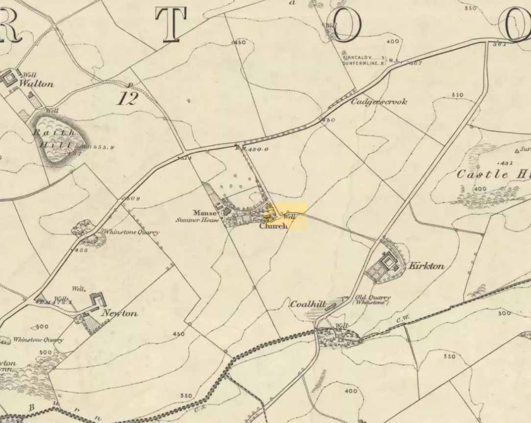
Along the B925 road between Dunfermline and Kirkcadly, ⅔ of a mile (1.07km) west of Auchtertool village, go down the small track leading down to the isolated church on the rise in some trees. Walk through the churchyard and out the other side where a small footpath runs downhill. 50-60 yards along, by the walling, this holy well is/was said to be.
Archaeology & History
Both history and tradition are pretty shallow on this all-but-forgotten site, which Penny Sinclair guided us to see in the summer of 2016. Sadly the entire area where the waters are reported to emerge were completely overgrown in nettles when we visited and, despite us trampling the Urtica down, we could find no remains of the spring. (the Church and its followers here should ensure that the well is properly maintained)
The greatest description of the site seems to be that given by William Stevenson (1908) in his rare work on the parish of Auchtertool. He wrote:
“As you approach the Kirk of Auchtertool by the old road…you come upon a well by the wayside. For many years it was the well that supplied the Manse with water, but it is now seldom used, even by the passing traveller. There is a belief that at one time this well was what is known as a holy well. Be that as it may, a friend of the late Rev. Walter Welsh, the late Dr Robert Wilson, caused a stone over the well to be inscribed with the following lines:
“Ye who the gently-winding path have trod,
To this fresh fount beside the house of God,
Taste the clear spring; and may each pilgrim know
The purer stream where living waters flow.””
The well was included in Ruth & Frank Morris’ (1982) survey, where they added that the waters from the well were “used in celebration of the mass.”
Tumulus (destroyed): OS Grid Reference – SP 8601 7510
Archaeology & History
According to a Mr Abner Brown (1846), this was one of two prehistoric cemeteries that once existed in Pytchley village, but very little seems to have been written about it. Found on the north side of the village in the field where an old limekiln once stood, this “apparently pagan” site was “about 350 yards northwards of the church.” From his brief description it seems that a large barrow here was accompanied by other smaller ones of the same period. They have all been destroyed.
Royal Commission Ancient & Historical Monuments, An Inventory of the Historic Monuments in the County of Northamptonshire – volume 2, HMSO: London 1979.
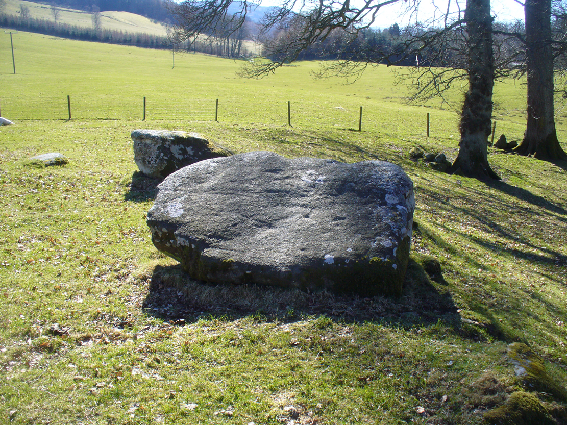
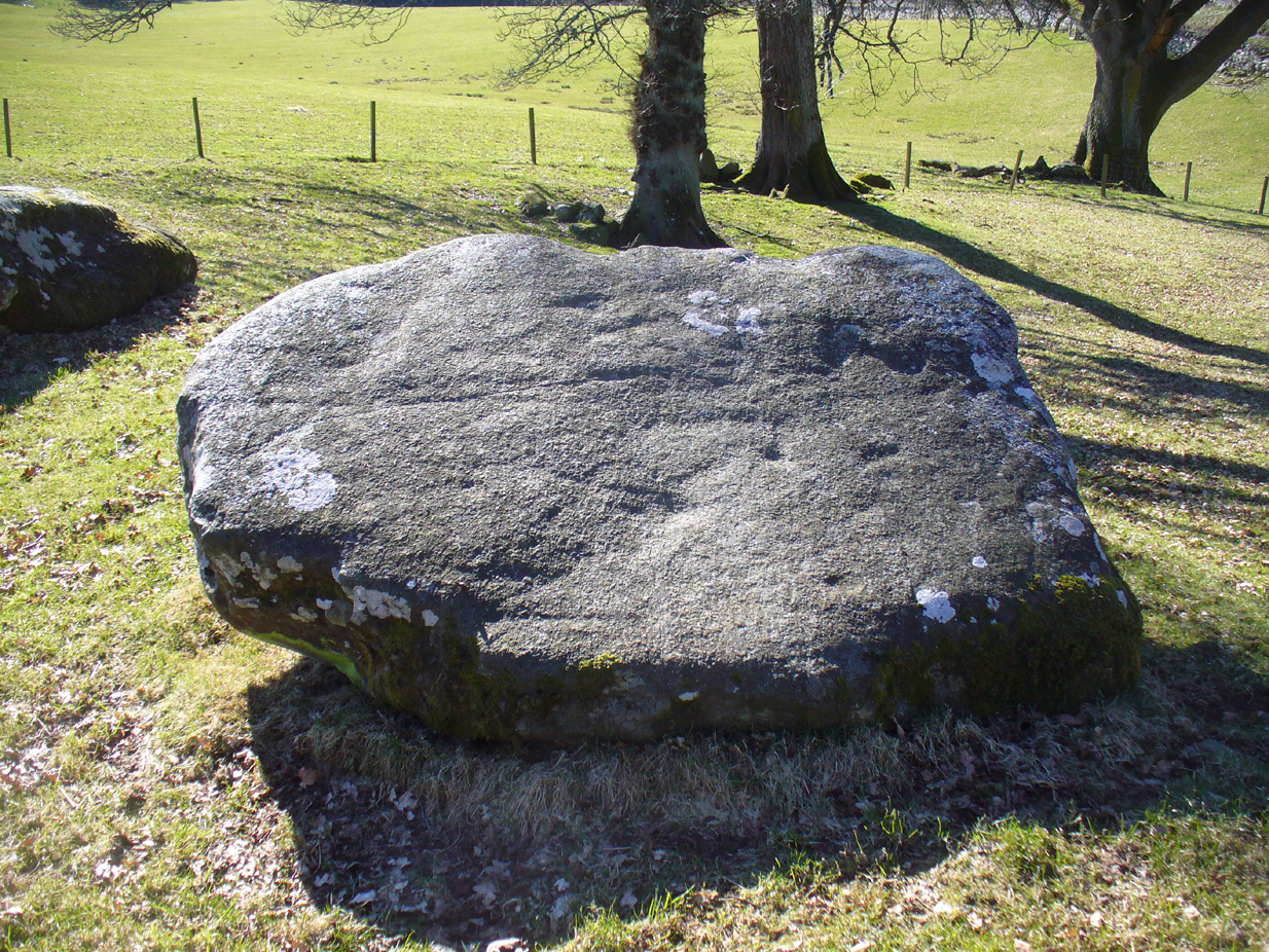
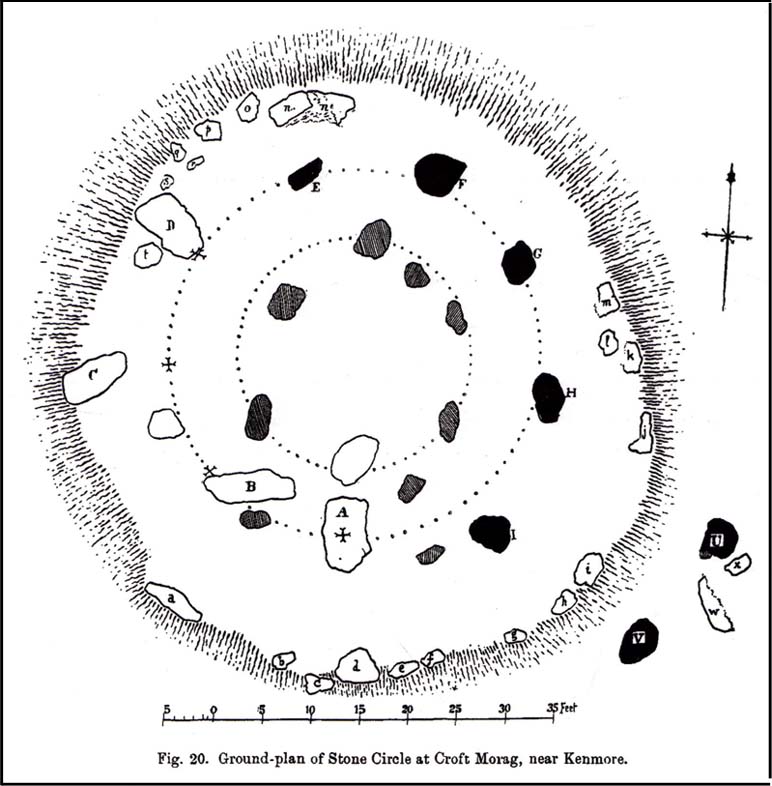
Follow the same directions for the Croft Moraig stone Circle. Then check out the largest of the fallen or elongated stones on the northwest side of the ring, with a smoothed sloping surface, just at the side of the overgrown stone platform on which it rests. Y’ can’t really miss it.
Archaeology & History
When William Gillies (1938) wrote about the carvings at the Croft Moraig stone circle, he told how, previously, Fred Coles,
“noticed that several of the upright stones…show cup-markings on their perpendicular surfaces. Some of these are quite distinct, but others are so worn through weathering that they can only be traced with the fingers.”
Stone D, with faint cupsClose-up of the cupmarks
This is one of them. Barely visible at the best of times, the cup-markings are faded and very hard to see unless daylight conditions are just right. As you can see in the photos, several distinct cup-like impressions are visible, but it only appears that two of them are cup-marks. The others seem to be more geophysical in nature – but I’d love to be wrong!
The great northern Antiquarian Fred Coles (1910) noted that this particular stone (stone D in his ground-plan of the circle) had “been polished by the sliding of generations of children”. This playful action on stones elsewhere in the UK and around the world sometimes relates to fertility rites (i.e., the spirit of the stone could imbue increased fertility upon the practitioner), but Mr Coles made no mention of such rituals here.
Gillies, William A., In Famed Breadalbane, Munro Press: Perth 1938.
Yellowlees, Sonia, Cupmarked Stones in Strathtay, Scotland Magazine: Edinburgh 2004.
Acknowledgements: Many thanks to hardcore crew for our various visits here: to Paul Hornby, Lisa Samson, Fraser Harrick, James Elkington, Penny & Thea Sinclair.
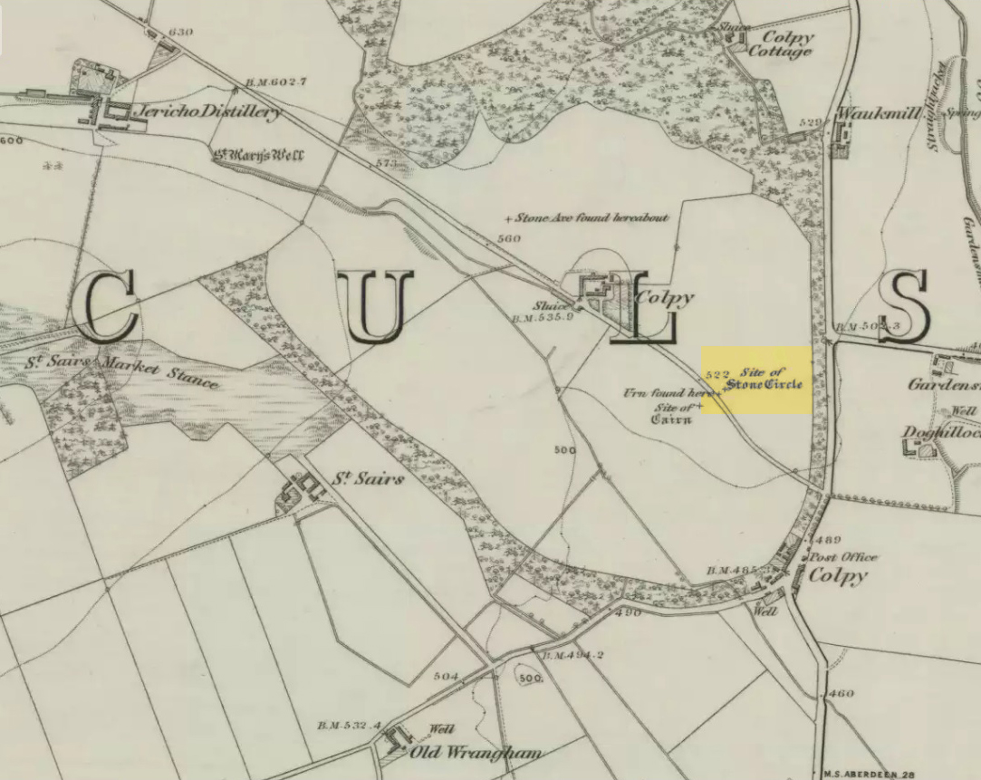
Just like the stone circle a half-mile east at Kirkton of Culsalmond, nothing now remains of this megalithic ring. It was first described very briefly by Rev. F. Ellis (1845) in the New Statistical Account as a “druidical temple”: one of two hereby, “on the farm of Colpie, although now almost obliterated. Several urns were dug up in making a road near one of them”—implying that one of them was a cairn circle or funerary monument of some kind. This was subsequently affirmed on the early OS-map and then described in Fred Coles’ (1902) survey, where he wrote:
“Site of a stone circle, the road going to Jericho Distillery having been made through it, and, on the south side of this road, the site of a cairn. Within the possible diameter of the circle an urn was found.”
Folklore
A few hundred yards west of the circle an ancient fair used to be held, known as St Sair’s Fair, named after St Serf. Although St Serf’s Day is July 1, early records show that the fair—held in a long field with the curious name of ‘St Sairs Market Stance’—was to be held on the Wednesday after the last Tuesday in June. For a stone circle, this is too close to Midsummer to be a coincidence! Early records show that the fair was granted in 1591 and subsequent years thereafter.
St Serf is a very peculiar mythological figure with quite shamanistic traits and tales around him. In truth, many of these early saints were little more than lapsed shamans, utilising natural magick and medicine in the olde traditions, but which became grafted onto the incoming christian mythos. The evidence for this is quite overwhelming!
References:
Barnatt, John, Stone Circles of Britain – volume 2, BAR: Oxford 1989.
Browne, G.F., On Some Antiquities in the Neighbourhood of Dunecht House, Aberdeenshire, Cambridge University Press 1921.
Burl, Aubrey, “The Recumbent Stone Circles of North-East Scotland”, in Proceedings Society of Antiquaries, Scotland, volume 102, 1973.
Burl, Aubrey, The Stone Circles of the British Isles, Yale University Press 1976.
Burl, Aubrey, The Stone Circles of Britain, Ireland and Brittany, Yale University Press 2000.
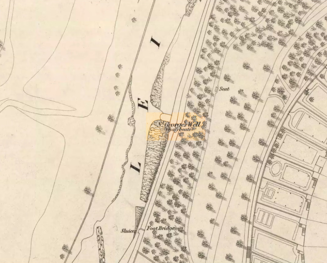
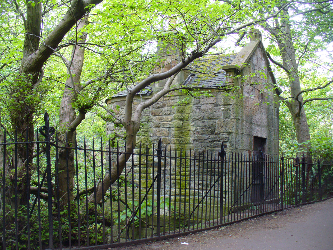
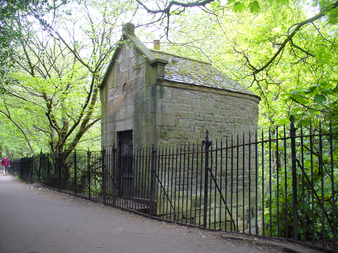
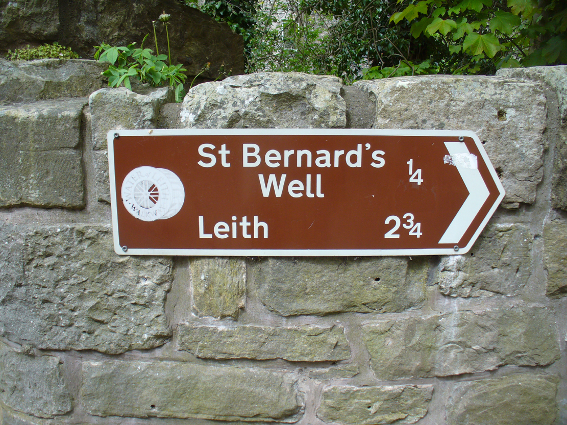
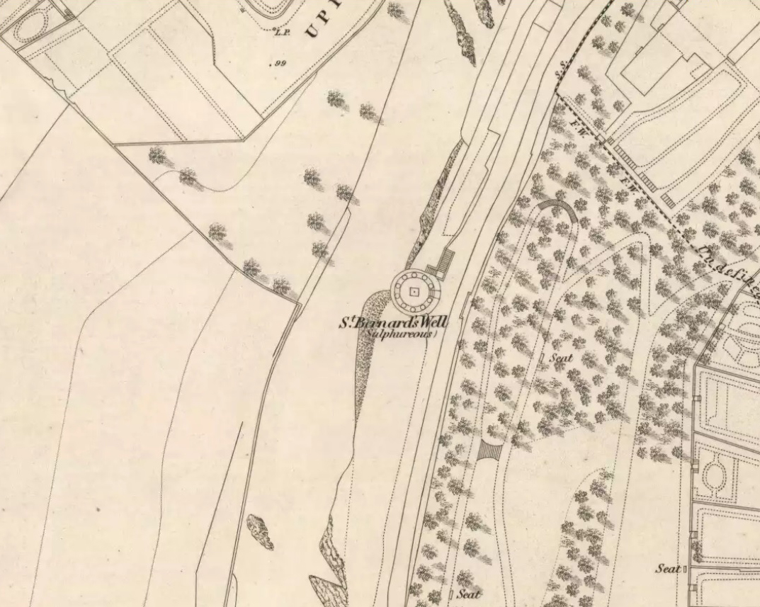
In Edinburgh, get to the west-end of Princes Street (nearest the castle), and where there’s the curious mess of 6 roads nearly skewing into each other, head down Queensferry Street for 450 yards until, just before you go over the bridge, walk down Bells Brae on your left, then turn right down Miller Row where you’ll see the sign to St. Bernard’s Well. St. George’s Well is the small, dilapidated spray-painted building right at the water’s edge 200 yards before St. Bernard’s site.
Archaeology & History
Compared to its companion holy well 200 yards downstream, poor old St. George’s Well is a paltry by comparison, in both historical and literary senses. The site was said to have been “set up in competition with St Bernard’s Well but never achieving its purpose”, wrote Ruth & Frank Morris (1982)—which is more than a little sad. Not on the fact that it failed, but on the fact that some halfwits were using local people’s water supply to make money out of and, when failing, locked up the medicinal spring and deny access to people to this day!
In Mr Grant’s Old & New Edinburgh (1882), the following short narrative was given of the site:
“A plain little circular building was erected in 1810 over (this) spring that existed a little to the westwards of St. Bernard’s, by Mr MacDonald of Stockbridge, who named it St. George Well. The water is said to be the same as the former, but if so, no use has been made of it for many years…”
St George’s Well, looking NSt George’s Well, looking SW
The association to St. George was in fact to commemorate the jubilee of King George III that year. If you visit the place, the run-down little building with its grafitti-door has a small stone engraving etched above it with the date ‘1810’ carved.
As the waters here were found to possess mainly iron, then smaller quantities of sulphur, magnesia and salts, it was designated as a chalybeate well. Its curative properties would be very similar to that of St. Bernard’s Well, which were very good at,
“assisting digestion in the stomach and first passages … cleansing the glandular system, and carrying their noxious contents by their respective emunctories out of the habit, without pain or fatigue; on the contrary, the patient feels himself lightsome and cheerful, and by degrees an increase to his general health, strength and spirits. The waters of St. Bernard’s Well operates for the most part as a strong diuretic. If drunk in a large quantity it becomes gently laxative, and powerfully promotes insensible perspiration. It likewise has a wonderfully exhilarating influence on the faculties of the mind.”
Royal Commission on the Ancient & Historical Monuments, Scotland, Inventory of the Ancient & Historical Monuments of the City of Edinburgh, HMSO: Edinburgh 1951.
So you’re in Edinburgh. Get to the west-end of Princes Street (nearest the castle), and where there’s the curious mess of 6 roads nearly skewing into each other, head down Queensferry Street for 450 yards until, just before you go over the bridge, walk down Bells Brae on your left, then turn right down Miller Row to the river where you’ll see the sign pointing the way! Walk alongside the river, past St George’s Well for another coupla hundred yards until you reach the large Romanesque domed building right by the riverside on your left. Steps take you down to it.
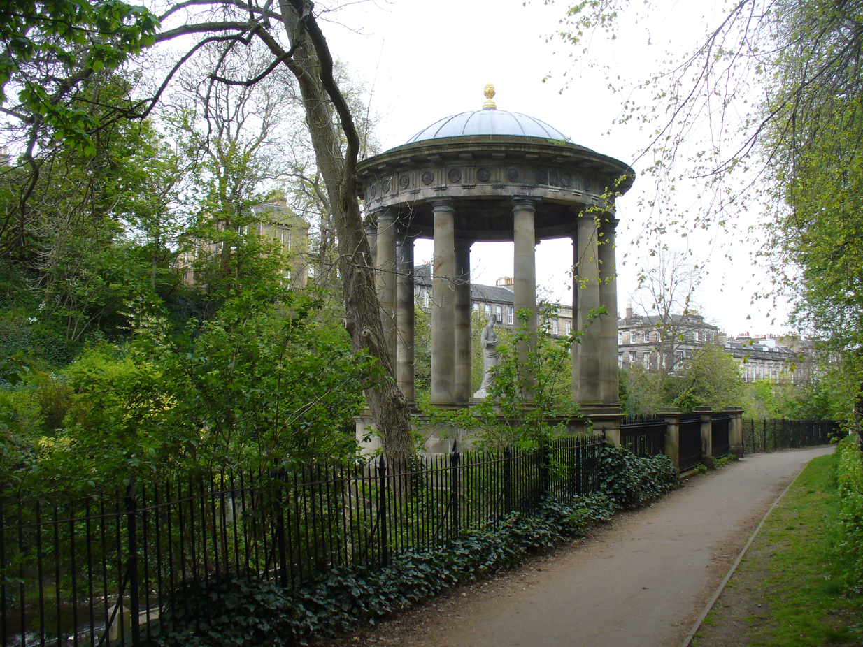
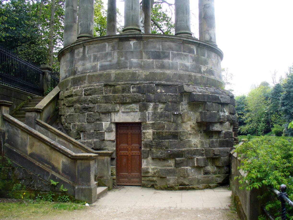
Archaeology & History
St Bernard’s Well, 1790
When J. Taylor (1790) wrote his singular book on St Bernard’s Well, this sacred site could be seen in landscape that was described as “a wild, romantic, and very pleasant appearance.” How things change! Although the waters of Leith below which the well arises give the region, still, that air of romanticism that Taylor described, on either side of the waters the stone buildings of the Industrialists have grown, denouncing Nature. But to be honest, it’s still a fine place, considering it’s near the middle of a city!
Small spring above the well
In the shrubs and small trees on the slopes just above the architectural edifice that now covers St Bernard’s Well, after rainy days you can see several small springs of water running down the slope and onto the modern path. In earlier centuries there were six of these springs next to each other which ran a short distance down the slope and converged into two, which then ran into a small stone trough. Local people used these fresh waters, not only for basic needs, but for medicinal purposes too.
It seems that the earliest mention of what Stuart Harris (1996) called “this fancy name” of St. Bernard’s Well appeared in an article in The Scots Magazine of September 1760. It clearly shows how the Scottish Freemasons played their part in bringing the waters of this healing well to the fore:
“A mineral well has lately been discovered between the village and the Water of Leith and Stockbridge, about half a mile north of Edinburgh, which is said to be equal in quality to any of the most famous in Britain. To preserve the well from the injury of the weather, and prevent its being overflowed by the Water of Leith, on the banks of which it is situated, a stone covering is to be erected over it. The foundation-stone of this building was laid September 15th (by a deputation from the Earl of Leven, the present Grand Master of Scotland), by Alexander Drummond, brother of Provost Drummond, lately British Consul at Aleppo, and Provincial Grand Master of all the Lodges in Asia and in Europe, out of Britain, holding of the Grand Lodge of Scotland. He was attended by many of the brethren, in their proper clothing and insignia, preceded by a band of music, and the ceremony was performed in the presence of a great number of spectators. It is called St. Bernard’s Well.”
The following year, the poet James Wilson Claudero wrote a poem about the laying of the foundation stone at the well, in which the medicinal virtues of the waters were described. A section of the poem is as follows:
“When heaven propitious to grant his desire
To the utmost extent his heart could require,
For the health of the poor sent this sanative well,
A blessing to all that around it do dwell;
This water so healthful near Edinburgh doth rise
Which not only Bath but Moffat outvies.
Most diseases of nature it quickly doth cure.
“It cleans the intestines and appetite gives
While morbific matter it quite away drives.
Its amazing effects can not be denied,
And drugs are quite useless where it is applied,
So what doctors can’t cure is done by this spring
Preserved till this year of great Drummond’s reign.”
St Bernards Well, looking NSt Bernards Well, looking SW
A few years later in 1786, the construction we see today which now covers the medicinal waters, began to be built. The ‘fashion’ of the rich and wealthy acquiring healing wells used by local people was in vogue at the time and the place became frequented by the usual snooty class of doods who played their social gatherings here. The Scots Magazine gave a brief resumé of what unfolded—intriguingly at Beltane (perhaps the day when its waters were of greatest repute, as is the case at the majority of sacred wells), telling:
“On the 1st of May, the foundation-stone of the mineral well of St Bernard’s, in the vicinity of Edinburgh, was laid in the presence of several gentlemen of the neighbourhood. A plate of metal was sunk into the stone, with the following inscription:
Erected For the benefit of the public at the sole expense of Francis Garden, Esq. of Troop A.D. 1789 Alexander Nasmith, Architect, John Wilson, Builder.
This building is erected in the most picturesque spot in the neighbourhood of Edinburgh, and when finished, from the elegance of the plan, and the excellent quality of the materials, will long be an ornament to the city, and prove a lasting monument of the refined taste, liberality, and public spirit of the honourable founder.”
As the reputation of the place spread amongst those who could read and had money, so the day-to-day habits of local people, who kept drinking the waters and collecting them for domestic use, became increasingly frowned upon. Some rich doods bought the land and, thereafter, local people were only allowed to use the well at certain times and in certain ways. I kid you not! This is a familiar tale at a lot of city sites. After the construction of the Romanesque building that still covers the well (based on an ancient temple at Tivoli, Italy, with a statue on top of the goddess of Health, Hygeia) which, to this day, hides the waters inside behind lock and key, the land-owner Lord Gardenstone appointed and paid a ‘keeper of the well’. The ‘keeper—George Murdoch of Stockbridge —had a series of rules to abide by, for which he got paid a tidy sum. Gardenstone wrote to him:
“George — From long experience I entertain a very favourable opinion of your honesty and decent manners. I, therefore, am resolved to make a trial of your capacity to perform properly the duties of a trust which is of a public nature, and requires good temper, patience, and discretion.
“I hereby authorise and appoint you to be Keeper of St Bernard’s Well during pleasure, and you are to observe punctually the following directions and rules, or such other regulations as may be found more expedient and may be hereafter prescribed:
“I. You are to furnish proper glasses and cups for drinking the water.
“II. During the proper season you are to attend the well, at least from six till nine, every morning. During the above period none shall have access to drink or use the water but those who shall pay at the moderate rates subjoined.
“III. Such as choose to subscribe for the season, from the 1st of May to the 1st of October, shall pay down, before they begin to drink, at least five shillings sterling.
“IV. Persons who do not choose to subscribe, but choose at their pleasure to drink the water any time of the morning period, occasionally, shall pay before they begin to drink every morning — for grown persons each one penny, and for children each one halfpenny; or at the rate of sixpence and threepence per week respectively.
“V. For water drawn from the well to be used at a distance, in bottles or other vessels in the mornings, payment must be made at the rate of one halfpenny for every Scots pint.
“VI. No person shall be allowed, on any pretence, to bathe their limbs or sores at, or in sight of, the well during the morning period.
“VII. All persons who are either unable or unwilling to pay as above, shall have free access to the use of the waters from ten to one every forenoon; and those who have once paid may return and use the waters at any time of the day.
“VIII. The keeper shall attend from five to seven o’clock in the afternoon for the service of all who have paid; and after seven for all without distinction.
“IX. Upon a proper certificate from any regular physician, surgeon, or apothecary of Edinburgh, the keeper shall supply poor persons with water at any time prescribed.
“X. The proper and customary method of drinking at mineral waters is, that persons after drinking a glass or cup of water retire immediately and walk about, or take other exercise for an interval of at least five minutes, both as a benefit to themselves, and to make way for other water drinkers. A contrary practice prevails at St Bernard’s, and sometimes a crowd of people continue at the well till they have drunk their quota. Hereafter every person must retire as above, and the keeper must require them to do so, this regulation being very necessary.
“XI. Another irregularity, prejudicial to the credit and use of the waters, has prevailed and must also be corrected, which is that quantities of the water are carried to distant parts in open vessels. All mineral waters should be transported in well- corked bottles or other close vessels. The keeper must strictly adhere to this regulation, and suffer no water to be carried off in open vessels.
“Hints and observations for the better regulation and public use of those waters will be thankfully received by the proprietor.
“Some accounts of the virtues of this mineral water, and of certain remarkable cures performed by the proper use of it, will soon be published by a medical gentleman of character and experience.
“N.B. — The effects of this water when used in making either tea or punch are remarkably agreeable.
St Bernards Well on the 1819 Kirlands map
This must have caused some friction amongst locals, and no doubt given Mr Murdoch problems at times, as he would be denying the people who were born and bred here access to their drinking and medicinal spring. And so a missive was written on July 4, 1810, which instructed the keeper “to supply the poor with water gratis each day from eleven to twelve o’ clock noon.” Sensible…..
By now, the properties and reputation of the waters were widespread among the elitists and money-addicts. St Bernard’s Well was being compared with the famous healing waters of Bath, Harrogate, Strathpeffer and more. Its cause was encouraged by a series of scientific reports that showed a variety of health-giving minerals in good quantities; and many cases of ‘cures’ were reported by those who drank here. When the local doctor, J. Taylor (1790) opened his treatise on this very issue, he began,
“In the course of my practice, having occasion to visit most of the families in Stockbridge, especially of the poorer sort, I was informed that St Bernard’s Well had been of great benefit to people that resorted to it for various complaints…”
Entrance to the wellSt Bernards Well on 1851 map
Many more cases were to follow. It was the chemical constituents in St. Bernard’s waters that did the trick—although most modern folk would squirm at the very look and whiff of them, as Taylor reported how “the peculiar odour of this water is somewhat nauseous”! That’s because they are primarily sulphurous in nature, along with good traces of iron, magnesia and salts. I’ve drank such waters at some of Yorkshire chalybeates and found them damn invigorating – but most folk won’t touch them with a barge-pole! (chlorinated flouridated tap-water seems most folk’s preference these days) Dr Taylor told how St. Bernard’s Well was very good at,
“assisting digestion in the stomach and first passages … cleansing the glandular system, and carrying their noxious contents by their respective emunctories out of the habit, without pain or fatigue; on the contrary, the patient feels himself lightsome and cheerful, and by degrees an increase to his general health, strength and spirits. The waters of St. Bernard’s Well operates for the most part as a strong diuretic. If drunk in a large quantity it becomes gently laxative, and powerfully promotes insensible perspiration. It likewise has a wonderfully exhilarating influence on the faculties of the mind.”
He thereafter cited a number of cases of people with various ailments whose illnesses were cured by these waters. I recommend a perusal of his work and the other references below for specifics on such matters. The writings on this one sacred site are plentiful indeed, and the bibliographic references are but a morsel of works that describe it.
Folklore
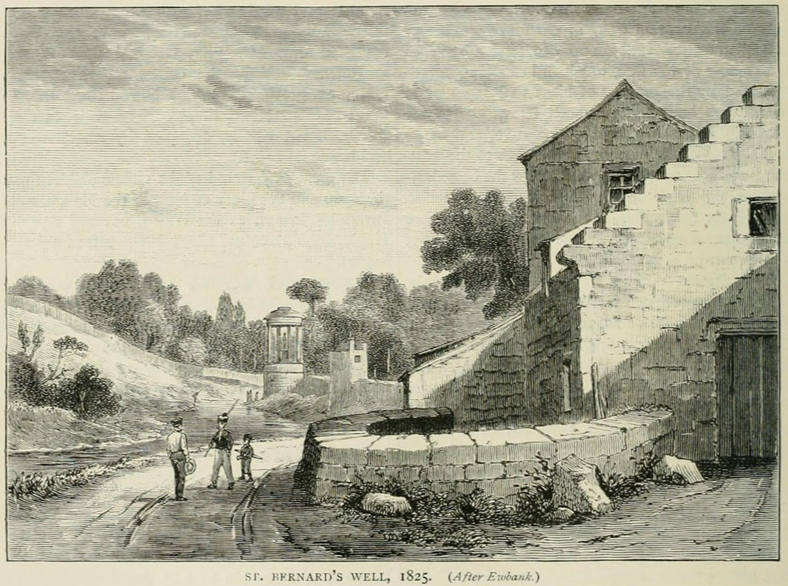
St Bernards Well in 1825
Local tradition ascribed the discovery of the medicinal waters here by three local boys from Heriot, years before the legendary St. Bernard got in on the act; and, despite the wishes of many, St. Bernard of Clairvaux was not in any way related to the legendary Nursie of Blackadder fame (can anyone find a short link so as to educate the unenlightened on this matter?). His hagiography (biography of a saint) tells that his saint’s day was August 20, and his symbols were: a white dog, a chained demon and beehives. Whether any of these symbols related to any indigenous myths at the site is difficult to say.
Mr Cumberland Hill (1887) told the story of how this spring acquired its christian title:
“There is an ancient oral tradition in the district (we read of it also in an old book when we were young) that St Bernard visited Scotland. There are different ways of telling the legend, but the following appears to be the general version. St Bernard, while preaching the second crusade in France and Germany, was advised to go to Scotland as a country rich in faith and fighting men. He was disappointed with his reception at court. In grief, aggravated by ill-health, he withdrew and lived in a cave in the neighbourhood of the spring. There certainly was a cave of considerable dimensions in the steep cliffs to the westward. Its entrance was covered up by the building of the wall that bounds the back of Randolph Crescent, but when it formed part of Lord Moray’s grounds we, and the other boys of Stockbridge, knew that cave well. The saint’s attention was attracted by the number of birds that resorted to the spring. He drank of its healing waters, and, soothed by the sound of the river and the beauty of the scenery — the valley, still very beautiful, must then have been surpassingly fair — his health and serenity of mind returned. He called the inhabitants of the district to the spring, revealed to them its virtues, and, after bestowing upon the people his blessing, he returned to his place of public duty. Christendom concurs that this was the blessing of a good man. He was canonised by the Roman Catholic Church, but as canonisation is growing to be an invidious distinction, we quote Luther’s opinion: “If there ever lived on the earth a God-fearing and holy monk, it was St Bernard of Clairvaux.” We give the tradition as a tradition, not as history, though it is as credible and certainly more creditable than many of the legends of the saints.”
Royal Commission on the Ancient & Historical Monuments, Scotland, Inventory of the Ancient & Historical Monuments of the City of Edinburgh, HMSO: Edinburgh 1951.
Sacred Well (lost): OS Grid Reference – SE 160 339
Archaeology & History
Which one is the Cruckleswell?
In an essay by great regional historian Harry Speight (1912) on the ancient tracks of Bradford and district, he mentions this “Cruckleswell” which was first described in 1602. Mentioned again in 1612 land deeds and several times thereafter, the site has long gone (been built over), but may have been a place where local people ascribed there being water spirits, or naiads.
Although the local historian W.E. Preston (1932) described the place as being in fields between Manningham Stoop (an old boundary stone, now lost) and Hallfield Cross (perhaps an old stone cross site, also lost), a more detailed article appeared a few years later by Wilfrid Robertshaw (1935), telling of its approximate location. He wrote:
“The interesting field-name of Cruckleswell occurs in 1664. Cruckleswell was situated between Manningham Stoope and Hallfield Cross. The latter name is here applied to some closes of land near the Bradford-Manningham boundary and not to a monument; but from this qualifying statement must not be inferred the opinion that a stone or wooden cross of the name never existed. From Manningham Stoope, whose location I have not traced, a lane led to Fair Gapp, which was just within the town of Bradford; but in 1686 there was a close called the Stoope, which adjoined Manningham Lower Lane on the left-hand side from Bradford to Manningham. The occupiers of Cruckleswells were ordered by the jurors of the Bradford Manor Court to take in the water which ran by their premises. The occurrence of a water-course thereabouts, together with the name, Cruckleswell, suggests that here, as in the Panewell Feilde, was a holy well of a kind. Perhaps the derivation of the name may be found in the Yorkshire dialect word ‘crukle,’ meaning to make crooked, or to bend or twist. In a sense, therefore, Cruckleswell was another pin well, into which bent of ‘cruckled’ pins were cast. Cruckleswells, or Crookewells, as the three closes of land were called in a deed of 1658, were then granted by Tempest Brighouse, of Bilbie in the county of Nottingham, to James Mitchell of Bradford, yeoman. But…I have found a deed of sale by Christopher Pighells of Bradford, yeoman, to John Nicholls of Horton, clerk, of the close of land called Cruckleswell… Nicholls purchased Cruckleswell in 1612, the year before Saxton produced his plan, on which the small field is shown adjoining others belonging to Pighells. Thus the plan fixes the location of Cruckleswell; it adjoined the east side of the highway leading from Bradford to Frizinghall and was just within the Manningham township.”
This would put it close to the Holy Well Ash well and its long-lost standing stone. The 1852 OS-map of this area shows an unnamed well between the Holy Well Ash and the boundary line, as highlighted above; but another unnamed well is to the north of the holy well. If we cross over the boundary line south and out of Manningham, three other wells existed less than 200 yards away. Anyone of these may have been the Cruckleswell.
Mr Robertson’s idea on the word ‘cruckle’ is echoed in A.H. Smith’s (1961) place-name analysis of the site, where he relates how the word is “possibly connected with the obsolete crookle, ‘to crook, bed.'” This is shown to be the case in Thomas Wright’s (1898) gigantic tome. And as “cruckling” pins was a common animistic practice in earlier centuries, this derivation of it—as being a well where offerings were given to the spirit of the waters—is not unlikely.
References:
Preston, W.E., ‘Some Local Holy Wells,’ in Bradford Antiquary, June 1932.
Robertshaw, Wilfrid (ed.), West Yorkshire Deeds (2 volumes), Bradford Historical & Antiquarian Society 1936.
Shepherd, Val, Historic Wells of Bradford, Heart of Albion: Wymeswold 1995.
Smith, A.H., The Place-Names of the West Riding of Yorkshire– volume 3, Cambridge University Press 1961.
Speight, Harry, ‘Ancient Streets and Lanes of Bradford as Portrayed in the Manor Court Rolls,’ in Bradford Antiquary, New Series 3, 1912.
Wright, Thomas, English Dialect Dictionary – volume 1, Henry Frowde: Oxford 1898.
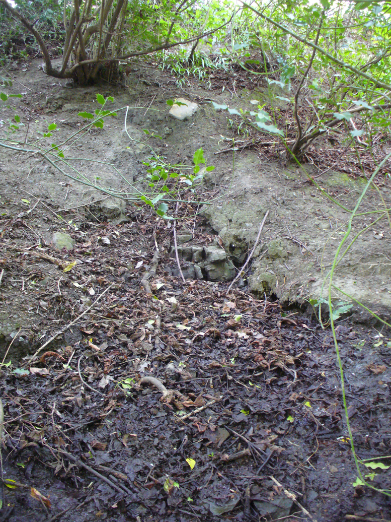
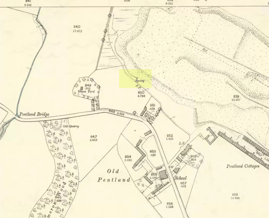
Described in Hope & Telford’s (1813) rare work, this little-known holy well has escaped the attention of all surveyors since then. It was one of four sacred and healing sites in the village and “the most copious” of them all, they said.
Located a little to the east of the old churchyard, chemical analysis showed its water to contain carbonates and sulphates of lime, “muriate of soda and a magnesium salt in very minute proportion, and carbonate of iron in a still smaller” amount.
Covering slabs on the wellThe ‘Spring’ on 1894 map
Until recently, the waters of St. Margaret could still be seen in the small copse of trees, just off the footpath, but they have now been covered in large stone slabs. Underneath them, you can clearly hear the sound of the rushing water still pouring out of the ground, quite copiously, as Hope & Telford said! A little further down the slope—into which the waters have cut a tiny glen—the ground is very boggy and marshy due to the outflow from the well. However, the waters here seem very dodgy indeed and it isn’t recommended that you try to drink them! (in the adjacent trees is a large dump site)
It is likely that the St. Margaret dedication here relates to the 11th century Scottish Queen, who was believed to have landed at nearby North Queensferry, known as St. Margaret’s Hope. Literary history tells that she became a Roman Catholic.