Dead easy! Near the western end of Caton village, right on the edge of the main road (A683) running through the village (south-side of the road), enclosed by railings, you’ll see the remains of this ancient tree, just by the side of the stream. Keep your eyes peeled!
Archaeology & History
The small scruffy-looking remnant of an oak standing here by the roadside in Caton village, surrounded by protective railings, is the dying remnants of the old tree, standing upon the sandstone steps which were known as the Fish Stones: a curious monument that has been listed as a protected monument by the Dept of National Heritage. A small plaque on the side tells:
“The three semi-circular sandstone steps, shaded by the oak tree, were used in medieval times by the monks of Cockersand Abbey to display and sell fish caught from the River Lune. The ancient oak tree, reputed to date back to the time of the druids, and the Fish Stones, have become a landmark and Symbol of Caton.”
Druid’s Oak, Caton
This was probably the local moot spot for villagers and those living in outlying farms and hills in medieval times. No doubt a market of some sort was also once here; perhaps even an old cross, as the Fish Stones have all the appearance of some village cross steps. I’ve found little else about this old tree, nor any folklore (but aint looked too hard if truth be had!). There’s surely more to be said about this once sacred tree.
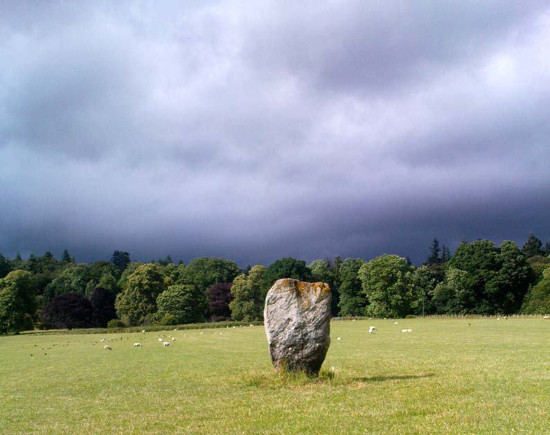
Going thru Pitlochry town, turn up the A924 road for about a mile till you hit the Moulin Inn on your left-hand side. Just past here, take the road left and continue for 2-300 yards until the stone in the field stands out on your right-hands side. Y’ can’t really miss it!
Archaeology & History
I should mebbe have this site entered as a ‘stone circle’ and not just an old monolith, as numerous other standing stones were in close attendant not too long ago and it was said to have been a circle. Certainly when the great Fred Coles (1908) talked about this place, he
“was informed by the tenant, Mr Reid…that many years ago, in his grandfather’s time, “there were several more stones standing”, all smaller than this monolith and that, upon the orders given by Mrs Grant Ferguson of Baledmund, some of these were saved from total demolition, and are supposed to be lying half-buried in the field to this day.”
…and here’s the big man close-up
Though I imagine these remnants have now been removed. Aerial images, when conditions are just right, might prove fruitful here.
But the solitary stone still standing here is quite a big fella. Heavily encrusted with quartz and more than 7 feet tall, it’s a nice fat chunky thing, with its lower half being somewhat slimmer than the top. Well worth having a look at!
Folklore
Once an old moot site, folklore also tells that an old market was once held here (there was some other folklore I had of this place, but can’t for the life of me find it at the moment!).
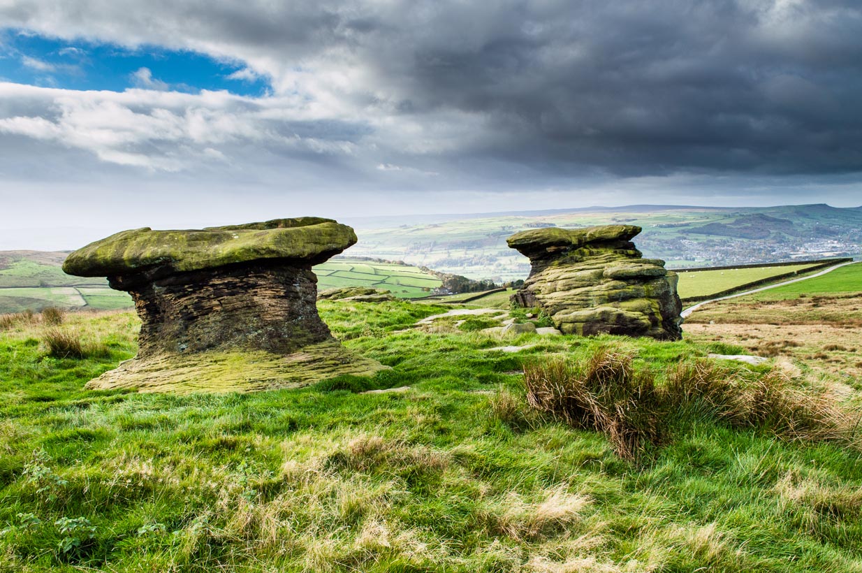
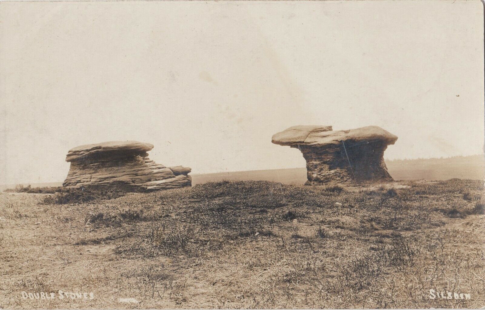
Various ways to get here, but the 2 most common are: (1) from Brunthwaite village, above Silsden, following the road uphill for a mile, then turning right (west) onto the moorland dirt-track to Doubler Stones Farm. Just before here there’s a footpath uphill (north) for 200 yards to the stones. (2) follow the Millenium Way footpath south up Addingham Moorside, onto Addingham High Moor. Keep going on the same path another 500 yards and they’ll appear ahead of you.
Archaeology & History
First described as the ‘Doublestones’ in the local Addingham parish records of 1786, these great mushroom-shaped rocks were later brought to the attention of archaeologists by J. Romilly Allen in 1879 and they greatly intrigued numerous Victorian antiquarians, who puzzled as much about their exotic forms as the cup-marks on their tops! Allen wrote of them:
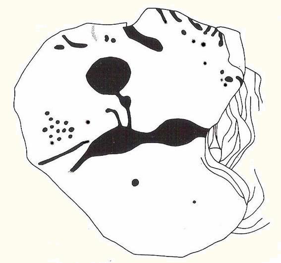
Cowling’s old drawingHedges (1986) sketch of the design
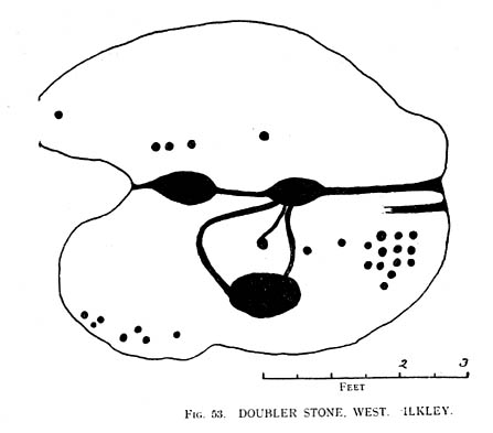
“These rocks are by far the most remarkable freaks of Nature to be seen in the district. They occupy a prominent position, perched on the extremity of a rocky knoll which juts out into the valley; and as seen from below, with their weird forms standing out clear and sharp against the background of blue sky, they present so extraordinary an appearance that they would at once attract the attention of even the most unobservant. In general outline they resemble gigantic toadstools; and I presume that they are called Doubler Stones from the fact of their shapes being almost identical. They may be appropriately described as Nature’s Twins. The upper surface of the cap of one of these stones has three large basin-shaped cavities in it. Two of these lie along the central axis of the stone, and measure respectively 1ft 3in by 2ft 9in deep, and 1ft 9in by 1ft 3in by 9in deep. They are united by a deep groove, a continuation of which runs out over the edge of the stone at each end. There is another basin lying to the west side of the two central ones, with one of which it is connected by grooves. It measures 2ft by 1ft 9in and is 9in deep. There is no direct evidence that these basins are artificial; but it is quite possible that they may have been so originally, and have been enlarged by natural agencies. But in addition to the basins, are twenty-six cup-markings of distinctly artificial origin. They vary in diameter from 2 to 4 in. One group of cups appears to be arranged in parallel rows.”
Doubler Stones, c.1890
Although the writer thought there were no artificial cup-markings on the other Doubler Stone (the one on the left in the photo), John Hedges (1986) and Boughey & Vickerman (2003) cite there to be at least two cup-markings on this rock. Other writers have given different numbers for the respective cup-marks thought to be on these rocks down the years.
If you’re into prehistoric rock-art, check this place out. If you’re a geologist and aint been here, you’ll be even more impressed!
Folklore
Approaching the Doublers (photo – James Elkington)
In Nicholas Size’s Haunted Moor (1934) he described the Doubler Stones as being the abode of ghosts and a place of sacrificial rites in ancient days. While in Guy Ragland Phillips’ Brigantia, we find that the word ‘doubler’ itself “is a large shallow dish, bowl or plate” – which we find on top of the greater one of these two well-worn-weirdoes. As well as being haunted, there is some other little-known, though not unexpected folklore here, which told these old stones to be the meeting place of witches in previous centuries.
In addition to this, we are told that the witches of Fewston valley to the west used to meet up with the more famous Pendle witches at these stones. One historian proclaimed that this notion was spurious, as it would be too far for the Pendle witches to walk – which says more about the historian in question than the people of previous centuries. The distance from Pendle to the Doublers can be traversed in a day and is an ideal meeting spot, away from the prying eyes of a wrathful Church, that sought war against the animistic practices of our ancestors.
References:
Allen, J. Romilly, ‘The Prehistoric Rock Sculptures of Ilkley,’ in Journal of the British Archaeological Association, volume 35, 1879.
Allen, J. Romilly, ‘Notice of Sculptured Rocks near Ilkley,’ ibid, volume 38, 1882.
Bennett, Paul, The Old Stones of Elmet, Capall Bann: Chieveley 2001.
Boughey & Vickerman, Prehistoric Rock Art of the West Riding, West Yorkshire Archaeology Service 2003.
Cowling, Eric T., Rombald’s Way, William Walker: Otley 1946.
Hedges, John, The Carved Rocks on Rombalds Moor, WYMCC: Wakefield 1986.
Jennings, Hargrave, Archaic Rock Inscriptions, A. Reader: London 1891.
Phillips, Guy Ragland, Brigantia: A Mysteriography, RKP: London 1976.
Size, Nicholas, The Haunted Moor, William Walker: Otley 1934.
This is the highest point of the moors, 1320 feet up. There’s various ways of getting there: I’d favour the wander up to Twelve Apostles then taking the 15 minute walk west to the triangulation point which marks the spot. If you reach the large rocky outcrop of the Thimble Stones, you’ve gone too far; although you can walk past the Thimbles, if you’ve started your walk from the two radio masts atop of the moor where the old Roman road hits the dirt-track. Either way, unless you’re damn stupid, this is an easy spot to find!
Archaeology & History
Although today there’s little to be seen, when Collyer & Turner (1885) described the place it was 175 yards in circumference! Bloody huge! When Harry Speight got here in 1900, it had shrunk slightly to 150 yards. Now however, almost all the stones have been robbed. I first came here when I was just 11 years old and remember it was a decent size even then – at least as large as the Little Skirtful and Great Skirtful of Stones more than a mile to the east. Today however, unless you knew it was once a giant cairn, you wouldn’t give it a second look.
It’s quite appalling what’s happened to this site thanks to the sheer ignorance and neglect of the local archaeologist in tandem with his paymasters at Bradford Council: 90% of the site has been utterly vandalised and destroyed as a result of these incompetent idiots in the last 20 years. Nowadays, all you can make out here is the raised earth for about 10 yards surrounding the trig-point. It seems that most of the stones that comprised this giant cairn have been taken for use in walling, and to prop up the stupid paved footpaths which the local Council and its affiliated halfwits are slowly building o’er these hills.* Morons!
Aar Dave on top o’ t’ moors
I’m not quite sure why it was called Nixon’s Station. It was J. Atkinson Busfield (1875) who mentioned this name, quite casually in his fine local history work, as if local folk had known it as such for sometime. There was also an inference of it being the resting place of some old general, but I’ve found nor heard anything more along such lines — though worra superb place for your spirit to roam free…..
If anyone has any old photos of this once giant prehistoric site, it would be good to see it in its old glory once again. When I wandered up here as a kid, I never carried things like a camera about (being a Luddite by nature!).
References:
Busfield, J.A., Fragments Relating to the History of Bingley Parish, Bradford 1875.
Collyer, R. & Turner, J.H., Ilkley, Ancient & Modern, Otley 1885.
* Anyone know exactly which idiots are responsible for the stone footpaths being laid over the moors here? They’re damn stupid and cause even more erosion and damage to the environment and prehistoric heritage up here, as anyone with an ounce of common sense can see. Can someone please get them stopped!?
Stone Circle (destroyed): OS Grid Reference – NT 774 292
Also known as:
Five Stones
The Tryst
Archaeology & History
Less than a mile northwest of the hillfort on Linton Hill, modern OS-maps show the field-name of ‘Five Stone Field’ which is where, in bygone years, another important stone circle once stood. Today unfortunately, not a single stone remains. As the Scottish Royal Commission (1956) lads told:
“About a mile NE of Frogden, on the N side of the road between Frogden and Greenlees, there were formerly five or six upright stones forming a circle, ‘about the size of a cock-pit’ (1792 Statistical Account). This circle, which was adopted as a rendezvous by Border raiders in the Middle Ages and became known as The Tryst, has long since disappeared, but its approximate site is indicated on the OS map by the name Five…Stone Field.”
Folklore
One of many stone circles used as an old moot, or gathering spot. This was described in one of the many footnotes to Sir Walter Scott’s (1802) Minstrelsy of the Scottish Border, in which he told:
“At Linton, in Roxburghshire, there is a circle of stones surrounding a smooth plot of turf, called the Tryst, or place of appointment, which tradition avers to have been the rendezvous of the neighbouring warriors. The name of the leader was cut in the turf, and the arrangement of the letters announced to his followers the course which he had taken.”
This tradition was echoed around the same period in Robert Forsyth’s (1805) massive work on the history of Scottish life and landscape, saying:
“In different parishes, such as Moorbattle, Linton, and others, are to be found what are called tryst stanes. These are great stones commonly situated on high grounds. They are placed perpendicularly in rows, not unfrequently in a circular direction. It is said, as also the name imports, that in times of hostility they marked the places of resort for the borderers when they were assembling for any expedition of importance.”
References:
Burl, Aubrey, The Stone Circles of Britain, Ireland and Brittany, Yale University Press 2000.
Forsyth, Robert, The Beauties of Scotland – volume 2, Thomas Bonar: Edinburgh 1805.
Royal Commission on the Ancient & Historical Monuments of Scotland, Roxburghshire – volume 1, HMSO: Edinburgh 1956.
Scott, Walter, Minstrelsy of the Scottish Border, James Ballantyne: Kelso 1802.
Stone Circle (destroyed): OS Grid Reference – SE 426 099
Archaeology & History
On the southern outskirts of Brierley and the northeastern edge of Grimethorpe is the curiously-named site of Ringstone Hill. I say “curiously,” as there are no physical remnants of anything which would presently tell us of there ever being such a ring of stones here — well, nothing authentic anyway! Some doods stuck a modern ring of stones here, but it’s pretty obviously a recent construction (apparently 1990-ish); but sometime in the not-too-distant past another circle, very probably prehistoric, could be found here…
First mentioned in 1591, the original stone circle which gave this place its name has seemingly gone; but the hill which preserves its name is a prominent place in the landscape, and this was very probably of some relevance to the builders. On the eastern side of the hill were two large oak trees known locally as Adam & Eve, or the Well-Bred Oaks: the first name implying a creation-myth story which may have related to the ring of stones. It also stands at the edge of the old boundary line along which, somewhere, was another tree called the Gospel Thorn, “where the gospel was read when beating the bounds.” (A.H. Smith 1961: 1:269)
This was a theme explored and developed in Mr Gomme’s (1880) old work on ancient meeting, or moot spots. He told:
“Ringston Hill, an eminence partly natural and partly artificial, is near a point at which meet the three wapentakes (district boundaries, PB) of Strafford, Stancross and Osgodcross. This mound appears to be connected in some manner with the early political state of this district. It was a place of rendezvous in the time of the Civil War; for in the accounts of the township of Sheffield in 1645 occurs this entry: ‘In money, coats and the charging of a guard which went to Ringston Hill with five men that were pressed, £4, 13s, 3d.’ (Hunter’s South Yorkshire ii, 407)”
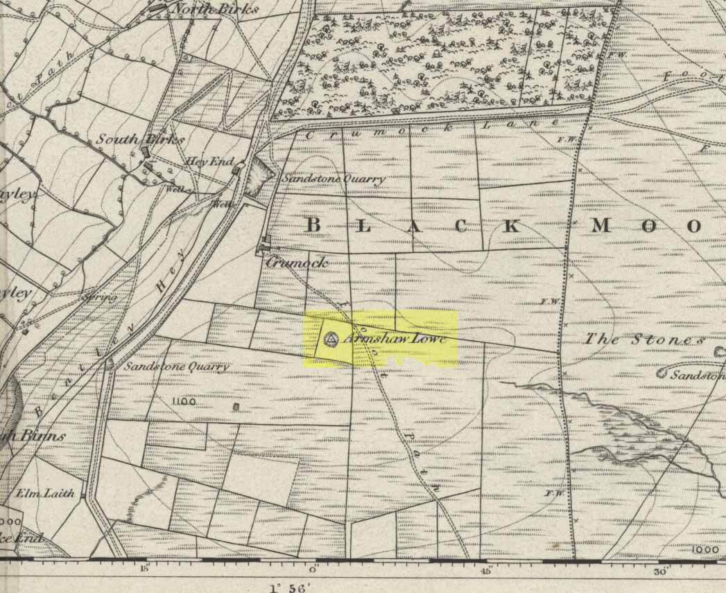
Go along the B6141 from Denholme to Oxenhope, turning right just by the bend which drops into Oxenhope, and head along the small road to Upwood Park camping site. Just before here is the Grange Park Animal sanctuary. Ask there to walk onto the field behind, where you’ll see a rise in the land, as you can see on the rather poor photo I took from the east-side.
Archaeology & History
Although ascribed on early OS-maps as a tumulus (and still shown as an antiquity on the modern ones), this site appears to be simply the end-point along a geological ridge, starting a few hundred yards east of here, consisting of an upsurge of rocks covered in earth and nothing more. A survey of the place done by Bellamy in 1970 (Yorkshire Archaeological Journal, 42:6, 1970) seems to indicate the same. To those who want to test the theory, start by exploring it from Cullingworth Moor and walk along the ridge itself. It seems pretty clear.
Armshaw Lowe – the small mound in centre of photo
The “antiquarian” element to the site seems to originate in its positioning in the landscape. Armshaw Lowe is on the topmost point of the hills hereabouts, with 360-degree views all round, commanding excellent sights all round. But it’s perhaps the word ‘lowe’ that might be the important bit here, as in old english it can mean an old moot or meeting spot — which it may well have been for local tribes. It is may be this element that gives Armshaw Lowe its lingering antiquarian status.
Check it out for yourselves and see what y’ think. I went up here to see an old burial mound, but found only a decent geological feature atop of local hills. But me ‘n’ the archaeologists might be wrong…
References:
Gomme, G.L., Primitive Folk-Moots; or Open-Air Assemblies in Britain, Sampson Low: London 1880.