From Dollar, take the steep road up to Castle Campbell (ask a local if you get lost). When you’ve got into the building and paid your fiver, walk straight forward as if you’re heading to the front gardens, but stay within the castle by walking left on the inner-front section of the building, all the way along to the dark room in the far corner at the end of the path. Just before you walk into the end room, look at the ground rock beneath your feet.
Archaeology & History
My first and only visit to the superb half-restored ruins of Castle Campbell was in the company of the author Marion Woolley. It was a damn good day and the castle here is really worth checking out! But as Marion and I wandered the grounds and internal remains, my eyes caught sight of what looked like a cluster of cup-markings, never previously recorded, on a section of earthfast rock over which a section of the Castle had been built.
A distinct arc of at least four cup-marks was accompanied with outlying single cups on either side of it. Beneath the gravel it seemed that more were waiting to be be unearthed—but we left them alone. As you can see in the photo here, the cup-marks seem typical of those we find in their thousands across northern Britain. However, the rock hereby is volcanic and conglomerate and may be the result of such natural processes. I’m truly not sure. A local archaeologist in Stirling thought the carving looked authentic – but we need to return here and brush off the rest of the gravel to see in greater detail the extent of the cups. There seemed to be more of them hiding at the edges.
If anyone finds out more about this, or gets some better photos, or ascertains this as a simple geophysical artifact, please lemme know.
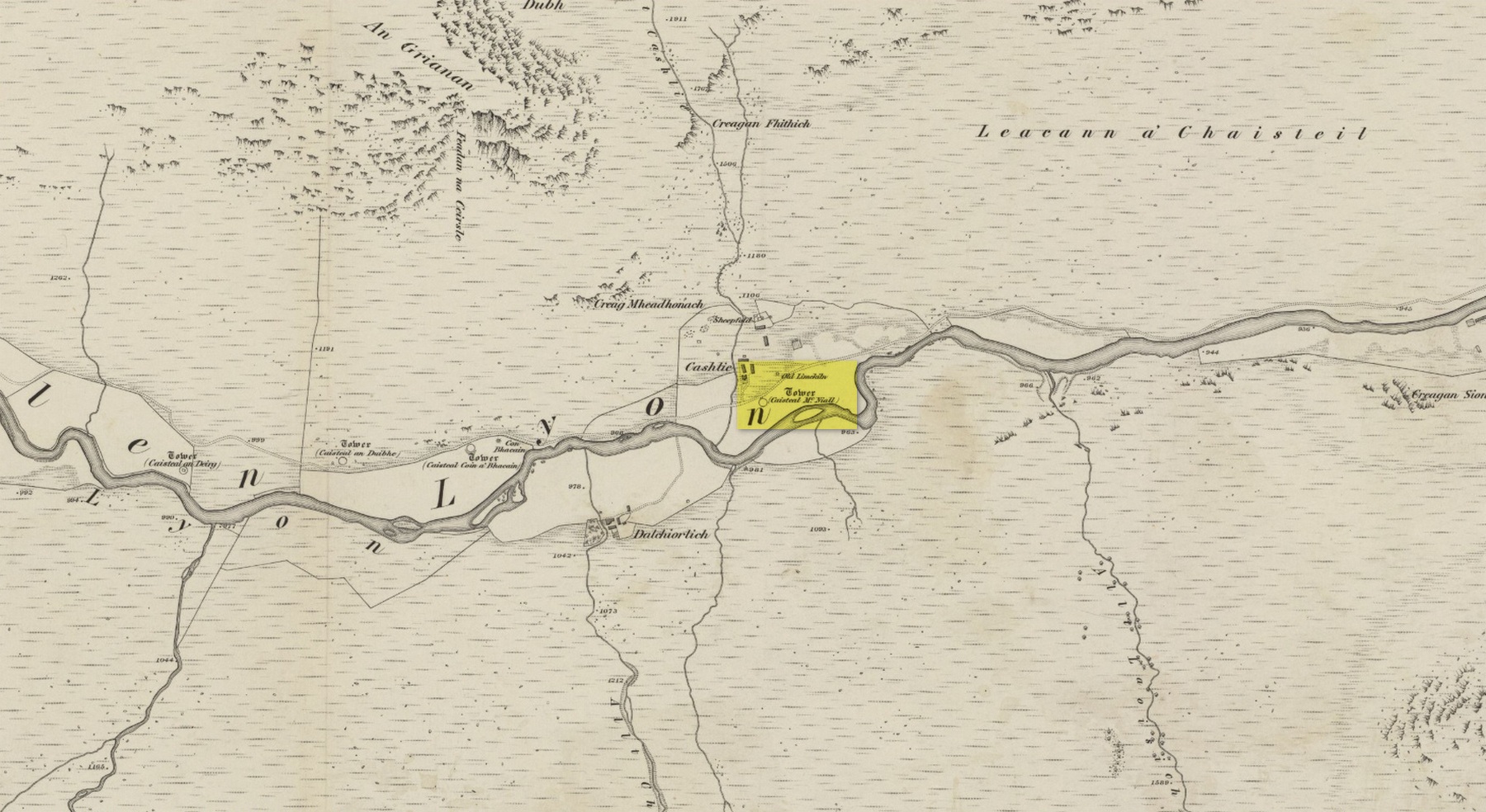
Dun (lost): OS Grid Reference – NN 539 386 (approximation)
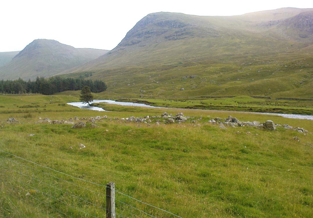
Looking towards Laraig Bhreislich, from the south
Also Known as:
Dun croisgh
Lairig Breisleich
Laraig Bhreislich
Archaeology & History
Although this site doesn’t appear in the modern records, the remote situation of the place suggests that some remains of the site could remain and be uncovered by diligent explorers and students. It is one of several lost “circular forts” that were described in William Gillies’ (1938) detailed historical text, that were first highlighted on a map of 1769. His brief description of this old fort told,
“The name ‘Duncroisg’ in Glenlochay, bears witness to the fort that once stood at the southern entrance to Laraig Bhreislich, the pass leading over the mountain to Glenlyon.”
There is is the possibility that some of the remote shielings clustered on the level at Airigh Allt an Eilein and Riabhaich used stones from this ancient site for their construction. On the level to the south of here are the overgrown remains of a prehistoric cairn, not included in archaeological surveys.
Note – Huge sections of prehistoric man-made walling have been located in the area, comprised of gigantic boulders, more reminiscent of enclosure walling. The remains are extensive and huge, but severely overgrown in this remote landscape. Watch This Space!
Folklore
Although not named specifically, this site would have been another of the Forts of the Fiann, or tribes of the hero-figure, Finn. The valley immediately adjacent to the location of the fort is still known as Fionn Ghleann, with the waters of Allt Fionn Ghleann strongly flowing through.
References:
Gillies, William A., In Famed Breadalbane, Munro Press: Perth 1938.
Truly remote, but easy to find once you’re nearing the western end of Glen Lyon. Going upstream, past Cashlie Dam, watch out for the well-preserved stone kiln on the left-hand side of the road, just before Cashlie house. 50 yards or further along, cross the road and in the field by the riverside, the circular mass of stones sorta gives the game away.
Archaeology & History
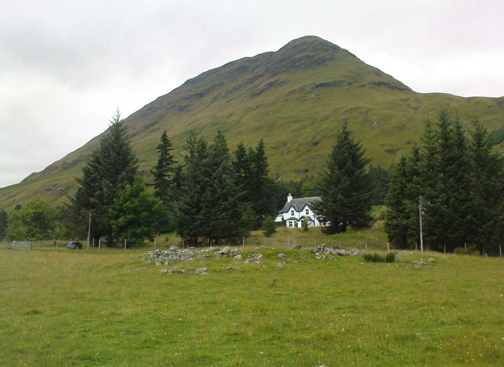
Shown on modern OS-maps as a ‘homestead’ and described variously by archaeologists and historians as a fort or a round-house, this is just one example of around twenty large prehistoric constructions that scatter the stunning mountainous Glen Lyon region which legend tells were the forts of the great hero-figure, Finn. Three other constructions of the same nature are found just a few hundred yards further up the Glen from here. Each is of roughly the same age and nature by the look of things. Their walls are extremely wide and made up of very large rocks, which would have taken huge efforts to construct.
Caisteal Mhic Neill ruins, looking eastCaisteal Mhic Neill, with An Grianan behind
Highlighted on the 1867 OS-map as a “Tower”, the exact nature of this and its adjacent sites has yet to be academically ascertained, with the Canmore website ascribing the monument as a “settlement” – although, tradition tells them to be Scottish forts or duns, so we’ll stick with that until excavations tell otherwise!
The great Gaelic place-name master W.J. Watson (1912) told that:
“The fourth of the Cashlie towers is a few yards south of the road, right in front of Cashlie farmhouse, now a shooting lodge. Though a quantity of large stones marks the site, the structure has been so badly knocked about that we found it impossible to take measurements sufficient for a plan. It was, however, apparently not circular, but rather oval. Its walls appeared to vary from about 9 feet to 12 feet 6 inches in thickness.”
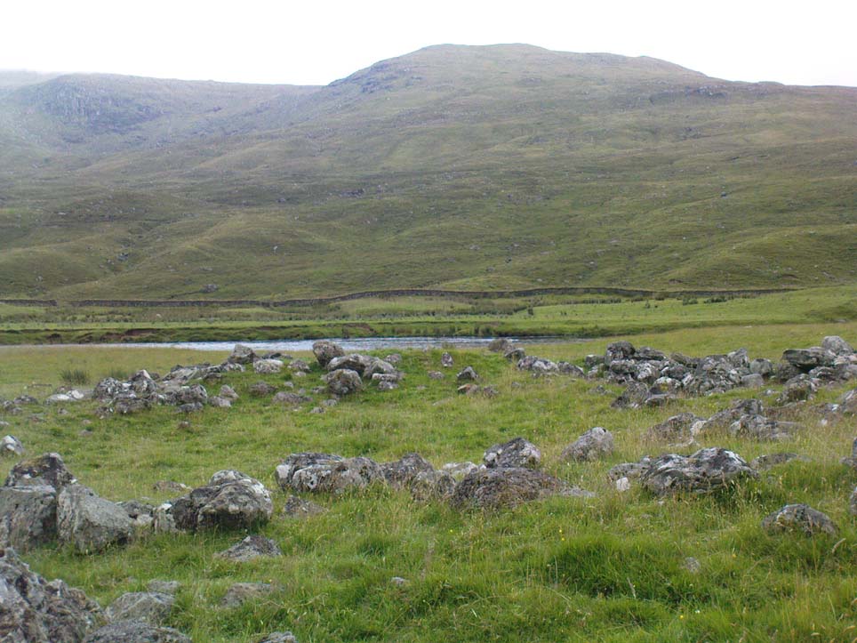
Close-up of Caisteal walling
This is one of several other duns (or homesteads as the OS-map calls them) close to each other.
Folklore
Ascribed as one of Glen Lyon’s Caisteilean nam Fiann, or “castles of the Fiann”, Mr Watson (1912) again told how “there is a widely known saying, the earliest notice of which occurs in Pennant, who got it doubtless from the Rev. J. Stewart:
‘…Twelve castles had Fionn,
In the dark Bent-glen of the stones.'”
References:
Gillies, William A., In Famed Breadalbane, Munro Press: Perth 1938.
Watson, W.J., “The Circular Forts of North Perthshire,” in Proceedings of the Society of Antiquaries, Scotland, volume 47, 1912.
ACKNOWLEDGEMENTS: Many thanks to Andy Sweet of Stravaiging Around Scotland, for pointing me to the W.J. Watson article. And of course, a huge thanks to Marion—”I don’t have a clue where I am!”—Woolley, for getting us here….
Either reach this from Dorchester’s Dyke Hills by crossing the bridge over the Thames at its southwestern side and walk thru the village and up the fields to the wooded rise on your left; or simply get take the road between Brightwell-cum-Sotwell to the delightful village of Little Wittenham and, on your right-hand side, notes the unmissable clump of trees and rise in the fields on your right. That’s the place!
Archaeology & History
Major Allen’s 1932 photo
To be found on the southern side of the River Thames, across from the huge Dyke Hills camp, this prominent enclosed hillfort was thought to be a place where the tribal peoples of differing groups converged — the Dubonni, the Catuvellauni, and Atrebates peoples. And to this day it remains impressive. Long thought to have been merely the province of Iron Age settlers, in more recent years it has shown to have had a longer and richer history than academics previously dare write about. In Jean Cook’s (1985) fine work on the archaeology of the region, she described the typical narrative Castle Hill elicited from professionals until only a few years back, saying:
“The hillfort on Wittenham Clumps covers approximately 4 hectares (c. 10 acres) and comprises a single ditch and rampart. It commands superb views northwards up the Thames valley and to the south and west across the Vale of White Horse to the Berkshire Downs, where a series of similar hillforts follows the line of an ancient route — the Ridgeway. The fort has never been excavated, although frequent past ploughings have produced Iron Age and early Saxon sherds as well as Romano-British pottery. However, to the south of the hillfort…a well-stratified Iron Age settlement was found. It seems probable on the basis of other excavated sites that the fort was permanently occupied. It would have developed as a regional administrative and political centre, with specialist craftsmen and traders and would have performed some of the same functions as a medieval market town.”
Although Cook’s latter remarks should be addressed with caution (market economics was far from the mythic perspectives of Iron Age people), this great site was of obvious importance. But later excavations at the site in 2002-03 showed that the site had in fact been used by neolithic people and, around the tops, flints and other remains were found that took human activity here back into mesolithic times, with some finds dated around 6000 BC! More surprisingly (to archaeologists anyway) was that Castle Hill continued to be used way into medieval times!
Thankfully much of this place is still pretty well-preserved and is well worth exploring to historians, pagans and walkers.
References:
Cook, Jean, “Before the Roman Conquest,” in Dorchester through the Ages, Oxford University 1985.
Cook, Jean & Rowley, Trevor (eds.), Dorchester through the Ages, Oxford University 1985.
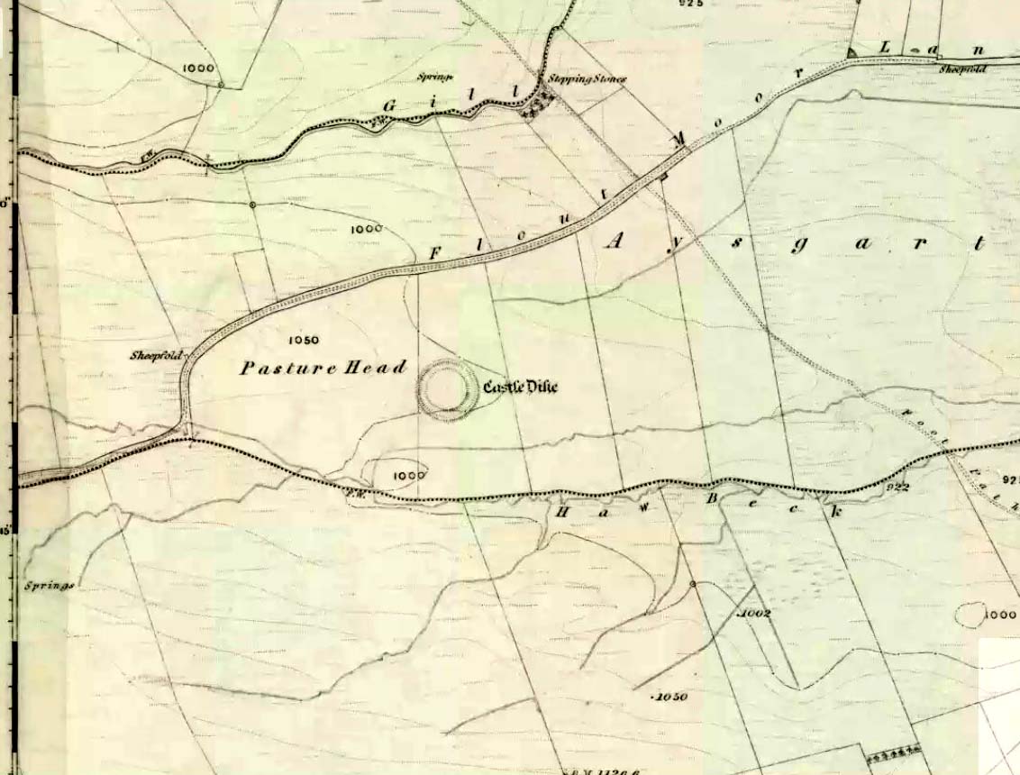
Go west through Aysgarth village along the A684 road and, just as you’re coming out of the town, take the left turn on the Thornton Rust road, past Town Head Farm, and turn left up the track (called Folly Lane). Go past the house where the track veers to your right and follow it straight on (don’t turn up the track on your left a short distance along). Keep walking on here for nearly a mile (about 10 mins), keeping your eyes peeled for the embanked rise in the field on your left, which is where the henge can be found! You’re damn close!
Archaeology & History
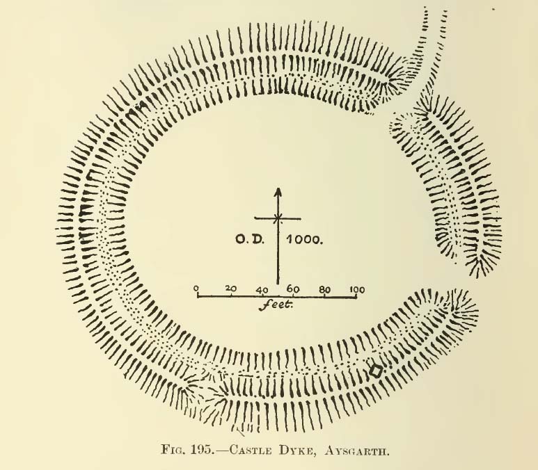
A.H. Allcroft’s 1908 plan
One of the earliest accounts I’ve found describing the Castle Dykes henge is in Mr Barker’s (1854) lovely literary exploration of Wensleydale, where he describes, “on Aysgarth Moor, which is now enclosed, may be seen a circular encampment, probably Danish” in origin. But he tells no more. When Edmund Bogg (c.1906) came here fifty years later, he added little extra, simply telling of, “the earthworks known as ‘Castle Dykes’, probably Angle or Danish, although Roman relics have been found here.” However, the brilliant Mr Speight (1897) gave what seems to be the earliest real description of the site when he described “the Celts” and the earliest settlers of the region, saying how:
“The so-called ‘Castle Dykes’ at Aysgarth betrays a probable connection with the same settlers. It is an irregular circular rampart, measuring about forty yards across its longest diameter, and not unlike the earthwork on Harkaside called ‘Maiden Castle’… A ditch completely encloses the mound, which, it should be noted, is unusually low, being little higher than the outer bank or upcast from the trench. It is totally different from the elaborate burh at Middleham; indeed, from its low and simply form, as well as from its situation in Celtic territory, there seems little doubt that it was the work of these early people.”
Ditch of Castle Dykes henge, looking east (photo credit – Richard Stroud)
Speight also made a suggestion that the place-name of Aysgarth itself may derive from this monument. He may have a point. A.H. Smith (1928) and other place-name authorities tell the name to derive from “an open space” either surrounded by, or — in some way — defined by oak trees. We might never know for sure…
Not long after the works of Speight and Bogg came the first real survey of British prehistoric earthworks by A.H. Allcroft (1908) — and amidst the mass of archaeological curiosities (as many were at the time) was another description of this great ceremonial monument. Allcroft told that here,
“a weak vallum of earth encloses a perfectly regular oval area measuring from crest to crest of the vallum 257 feet (east to west) by 217 feet (north to south). Immediately within the vallum is a broad fosse varying from 25 to 32 feet in width. The vallum at its highest (east) rises not more than seven feet above the floor of the fosse. The “island” measures 196 by 160 feet and is perfectly flat. There is no berm and no outer fosse. The vallum is broken by three gaps, of which that to the southeast is apparently original, as the fosse has never been excavated across it. The other gaps point respectively northeast and south-southwest, the latter being a mere depression like that to be seen at the eastern side of the northern ring at Thornborough. At one point in the vallum, on the southeast, a single large stone rises slightly above the turf which otherwise covers the whole work, and certain depressions observable at other points suggest that other such blocks have been removed —that, in fact, it originally had a peristalith standing upon the vallum. The principal entrance looks towards Pen Hill…”
Around the same time, the early scientific discipline of astroarchaeology was taking root and in Sir Norman Lockyer’s Nature journal, the reverend J. Griffith (1908) explored the potential astronomical orientation of Aysgarth’s Castle Dykes, thinking that the main entrance to the site gave indications of an alignment towards either Alpha Centauri or Capella. Y’ never know…
Although many visitors and local people knew of Castle Dykes, it was pretty late before the site gained status as a henge monument. This happened following a visit here by the pedantic archaeologist R.J.C. Atkinson (1951) in September of 1948. Following his visit, Atkinson described the place, saying:
“It consists of an oval enclosure bounded by a well-preserved ditch and external bank, with an entrance on the East side. Two small gaps in the bank, without corresponding causeways across the ditch, were probably made in recent times to allow the escape downhill of the surface water which collects in the ditch. The dimensions in H. Allcroft’s plan are incorrect. The markedly oval shape is probably in part dictated by the situation, in order that as much as possible of the enclosed area should lie on the level ground topping the ridge. There is no sign of any stone structure in the central area, but the district abounds in stone walls, for which the site may have been robbed in the past.”
Aerial image
In more recent years, archaeologists have speculated that the site was a sacred site or meeting place, aswell as a site where trade occurred, particularly a place where axes were traded; but this latter idea is more due to the projection of a modern religious notion, of ‘The Market’ with little veracity in terms of the site’s function. This increasing imposition of ‘economics’ and ‘trade’ (see Brown 2008:44-6) as vital ingredients to this and other sites has little relevance outside of a simple epiphenomenalistic adjunct to magical and tribal exchanges. But such notions are outside of archaeological frameworks, so we shouldn’t be surprised at so prevalent an error.
But this place is damn impressive — though with the exception of Mr Griffith, one notable ingredient archaeologists seem to have forgotten about was the position of this site in the landscape. The views surrounding the henge are excellent, giving a 360° arena all round. If the monument once had a ring of stones around it, as Allcroft suggested, the views would still have been the same. A modern excavation here might prove worthwhile and, as a result, open up once again, the potential for further astronomical investigations with the many hills and notches along the living horizon. This site, whilst requiring analysis of it as a ‘specimen’, must also be placed in the context of the wider living environment which, to all early traditional cultures, were such important and integral ingredients.
We have also found some previously unrecorded prehistoric remains nearby which, hopefully, we’ll be able to explore a little more in 2011 and report here.
…to be continued…
References:
Allcroft, A. Hadrian, Earthwork of England, MacMillan: London 1908.
Atkinson, R.J.C., “The Henge Monuments of Great Britain,” in Atkinson, Piggott & Sandars’ Excavations at Dorchester, Oxon (Department of Antiquities: Oxford 1951).
Barker, W.G.M.J., The Three Days of Wensleydale, Charles Dolman: London 1854.
Bogg, Edmund, Wensleydale and the Lower Vale of Yore, E. Bogg: Leeds (c.1906).
Brown, Paul & Barbara, Prehistoric Rock Art in the Northern Dales, Tempus: Stroud 2008.
Griffith, Rev. J., “English Earthworks and their Orientation,” in Nature, volume 80, 18 March 1909.
Harding, A.F., Henge Monuments and Related Sites of Great Britain, BAR 175: Oxford 1987.
Smith, A.H., The Place-Names of the North Riding of Yorkshire,Cambridge University Press 1928.
Speight, Harry, Romantic Richmondshire, Elliot Stock: London 1897.
Acknowledgements: Many thanks to Richard Stroud for use of his photo of the henge.
Taking the A629 road between Shepley and Ingbirchworth, as you hit the staggered crossroads at High Flatts, take the west turn up the slightly sloping straight road of Windmill Lane. Just where the road ‘kinks’ at a small bend, stop and look into the field on your left.
Archaeology & History
Deemed by some as a hillfort, and others as settlement remains, what little are left of the remaining earthworks here were first described by local historian Henry Morehouse in 1861. Found about a mile west of Upper Denby, the site was described in the Victoria County History as being “on a commanding though not exactly a defensive situation on the slope of a hill.” This remark coming from the belief (and that’s all it is) that this was an Iron Age castle site. In 1924 James Petch said of it,
“The earthwork seems originally to have been almost square, and two sides and an angle remain. The external ditch is from ten to twelve feet broad in its present state.”
While Faull & Moorhouse (1981) tell of there being “evidence for Neolithic activity” here, modern surveyors reckon it as an old prehistoric settlement — which makes sense; though little of the site remains to be seen today.
References:
Faull, M.L. & Moorhouse, S.A., West Yorkshire: An Archaeological Survey, I, WYMCC: Wakefield 1981.
Morehouse, Henry James, History and Antiquities of the Parish of Kirkburton and the Graveship of Holme, Roebuck: Huddersfield 1861.
Petch, James A., Early Man in the District of Huddersfield, Huddersfield 1924.
This old stone is another one tucked away, but not too far south of Oban. Take the Kilninver road and keep heading southwest, past Loch Seil. Instead of following the road right, to Clachan and then onto Seil Island, bear left and towards Armaddy Castle. Where the single-track road turns into the woodland towards the castle, the track keeps on into the rocky hills. Keep going for about another 500 yards. You’re nearly there!
Folklore
By the coast just north of Loch Melfort, near the hamlet of Degnish, is the grand old Armaddy Castle. On the other side of the trees from here, to the east, Scottish writer and folklorist A.A. MacGregor tells there to be an old standing stone. In his Ghost Book of 1955, he tells the tale of a local man called Donald MacDougal who, returning home after his day’s work at the castle, crossed over the old burn of Eas nan Caerdach where the standing stone can be found, just past the bend in the track.
On reaching it, Donald became aware of a strange light a short distance in front of him. Thinking at first it was the lamp of his co-worker making for the Home Farm, he walked past the stone – but it wasn’t until he got home himself and found he was alone that he questioned what on earth he’d seen! Upon asking other people in the neighbourhood, it was found that other locals had seen the same light, traversing the land from the old standing stone along the footpath to the farm.
References:
MacGregor, Alasdair Alpin, The Ghost Book, Robert Hale: London 1955.


")