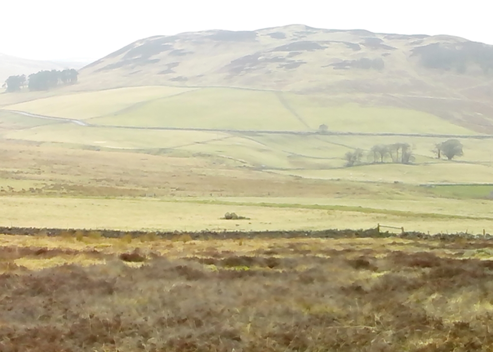
Landscape of Giants Knowe (photo by Marion Woolley)
Amidst the colourful and nurturing landscape close to the gigantic Dunruchan standing stones and just along the road from the solitary Craigneich stone, in the field across the road above Straid farmhouse could once be seen a fascinating-sounding prehistoric site that has sadly been destroyed. Some of the remains of this old monument can be found in the field-clearance of stones just over the fence, above the top of the field (many fields round here have scatterings of large stone clearings at the field edges), but we have no detailed accounts of the site. It was mentioned in early notes by the Ordnance Survey to have been,
“A large circular heap of small stone and gravel entirely removed in 1831. An urn filled with ashes and several stone coffins were found under it.”
The local historian John Shearer (1883) later told us that,
“A small mound of earth on the farm of Strayd, called Crock-nafion or the Giant’s Knowe, or the Fingalian’s Knowe, was cleared away several years ago. An urn containing burnt bones was discovered.”
Any additional information about this site and its folklore, would be greatly appreciated.
Folklore
To the west along Glen Artney whence our view takes us from here, old legend told that the valley was once the abode of a great giant who lived in a cave in one of the mountains thereby. In mythic lore, giants were the creation deities of hills, mountains and other geological forms, whose narratives were overturned and demonized by the incoming christian cult many centuries ago. It is likely that this once great tomb was deemed as the burial-place of our local giant – which would make this prehistoric site neolithic in age. But — logical though it is — this idea is pure speculation…
References:
Hunter, John, Chronicles of Strathearn, David Philips: Crieff 1896.
Shearer, John, Antiquities of Strathearn, David Philips: Crieff, 1883.
Thought to have been destroyed in the 19th century, folklorists and historians alike didn’t seem to be able to locate this little-known folklore relic, which is still alive and well in one of the fields by the village. The exact nature of the stone isn’t known for certain. Legend reputes it to have been one of the four boundary stones which gave the village its name; it was also said that they were Roman altars and the Fairy Stone was one of them, which was moved from the village boundary during the Rebellion of 1715 and placed nearer the centre.
Folklorist M.C. Balfour (1904) seemed to think that stone had gone when he wrote about it. Writing about it in the past tense, he told,
“The Fairy Stone however, certainly had an existence, for a person, 80 years of age, remembered its situation to the south of the village, near the old road, and that it was squared, and had a square “cistern hewn out of its top,” which was called the Fairy Trough, and traditionally said to have had a pillar fixed in it.”
But when former Ley Hunter editor Paul Screeton (1982) came looking for the stone in the late 1970s, he was fortunate in coming across an old local:
“Some time ago while looking for the Fairy Stone at Fourstones…I came across a farmer who pointed it out and remarked that a few years previously when the road was widened the local lengthsman made sure it was not destroyed, though it had to be moved a short distance.”
Folklore
Of the four boundary stones surrounding the village, they were “supposed to have been formed to hold holy water,” said Balfour (1904). But the title Fairy Stone given to one of them had this tale to account for it:
“A couple of miles or more down the South Tyne is Fourstones, so called because of four stones, said to have been Roman altars, having been used to mark its boundaries. A romantic use was made of one of these stones in the early days of “The Fifteen.” Every evening, as dusk fell, a little figure, clad in green, stole up to the ancient altar, which had been slightly hollowed out, and, taking out a packet, laid another in its place. The mysterious packets, placed there so secretly, were letters from the Jacobites of the neighbourhood to each other; and the little figure in green was a boy who acted as messenger for them. No wonder that the people of the district gave this altar the name of the ‘Fairy Stone’.”
References:
Balfour, M.C., Country Folk-lore volume 4: Examples of Printed Folk-lore Concerning Northumberland, David Nutt: London 1904.
Screeton, Paul, “The Long Man of Wilmington,” in The Ley Hunter, no.92, 1982.
Terry, Jean F., Northumberland Yesterday and Today, Andrew Reid: Newcastle 1913.
Watson, Godfrey, Northumberland Place Names, Sandhill: Morpeth 1995.
Acknowledgements: Big thanks to Paul Screeton for the grid-reference!
Probably the easiest (direction wise) is if you’re coming from Dick Hudson’s public house on the southern road surrounding Rombalds Moor. From the pub, head left (east) along Otley Road (passing Weecher reservoir) for 1.9 miles (3.1km) until you reach Reva reservoir where a track leads you to the waters. A small parking spot is on the left-side of the road. From here, go through the gate and along the footpath across the field for nearly 300 yards to the next gate; go through here and walk to your right for about 60 yards where uyou’ll reach a small straight dyke (keep your eyes peeled!) running NW (to your left): walk along here for nearly 200 yards until it hits another shallow dyke bearing right; follow this dead straight for 35 yards after which it changes direction, but you need to keep walking straight on forward for another 60 yards or so. Look around!
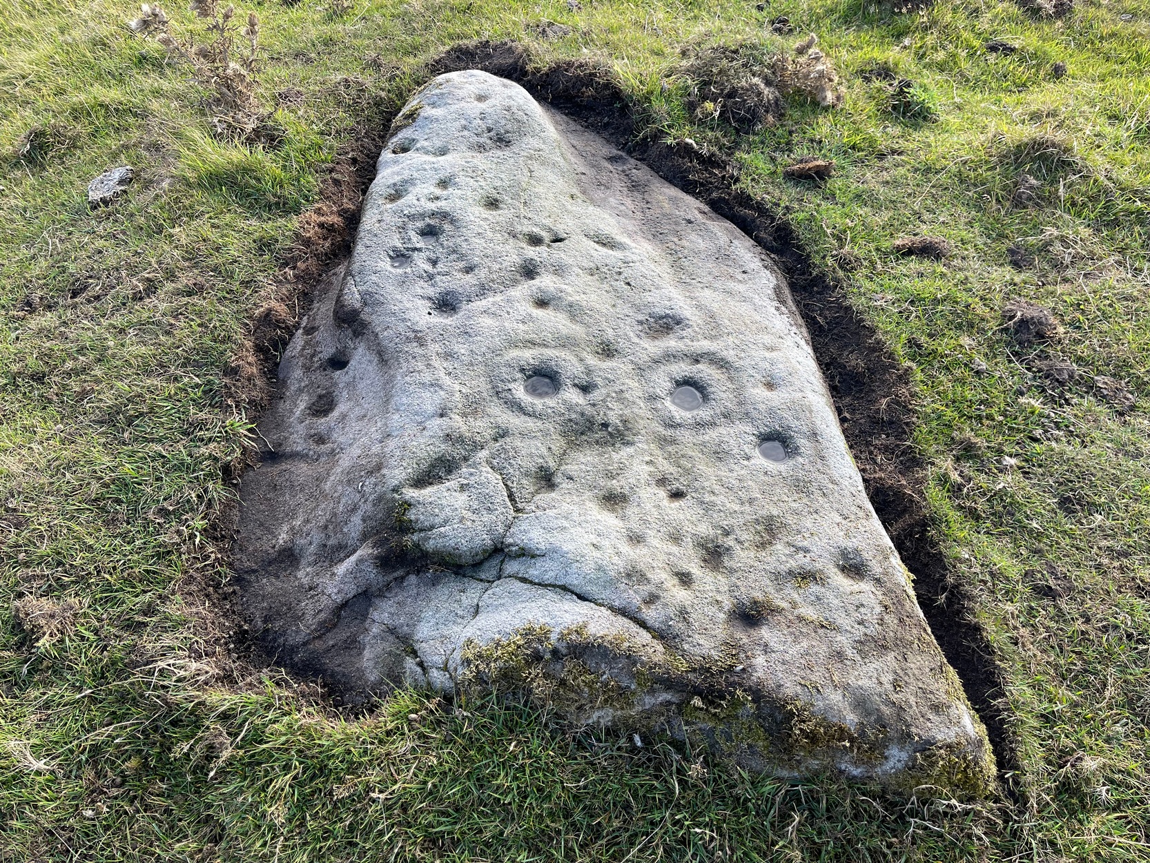
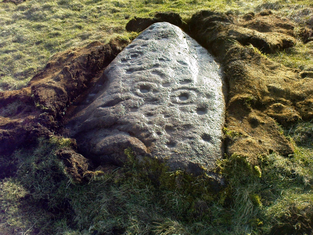
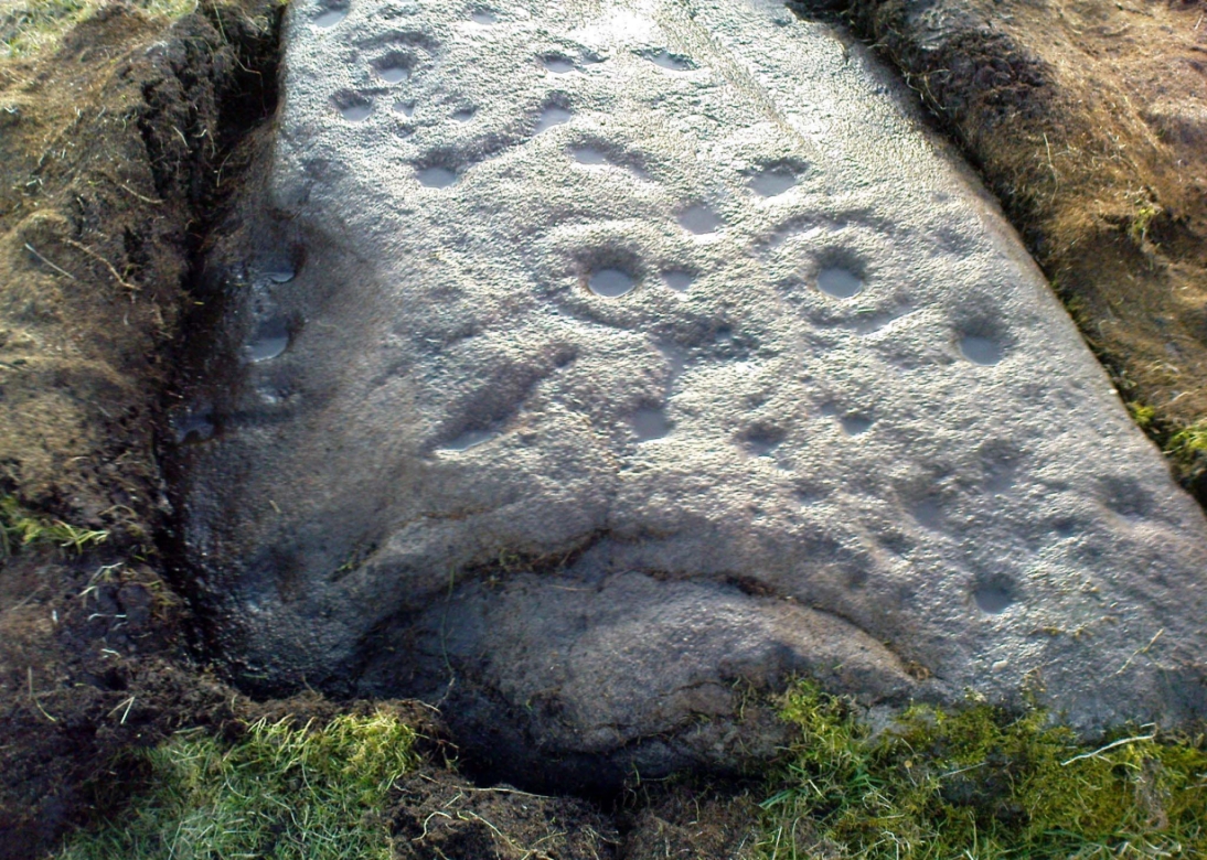
Archaeology & History
First photo of the carving
This carving is one in a cluster of previously unrecorded petroglyphs, uncovered in the summer of 2011 during a Northern Antiquarian bimble on the northern edge of Rombald’s Moor. The carvings were found as a bi-product of uncovering a previously undiscovered cairn circle, close to the Twelve Apostles stone circle. In assessing and exploring the newly-found circle, it was noticed that a small opening in the near horizon highlighted a rise in the landscape barely a mile away. This ‘opening’ in the land was not visible if you walked 25 yards either side of the cairn circle – but was very notable at the circle itself.
“We need to have a look at that site,” I said. “It’s position looks to have been relevant to this circle.” (or words to that effect) And a couple of weeks later we met up and walked to the place in question.
Fraggle Rock carving, looking westFraggle Rock carving, looking south
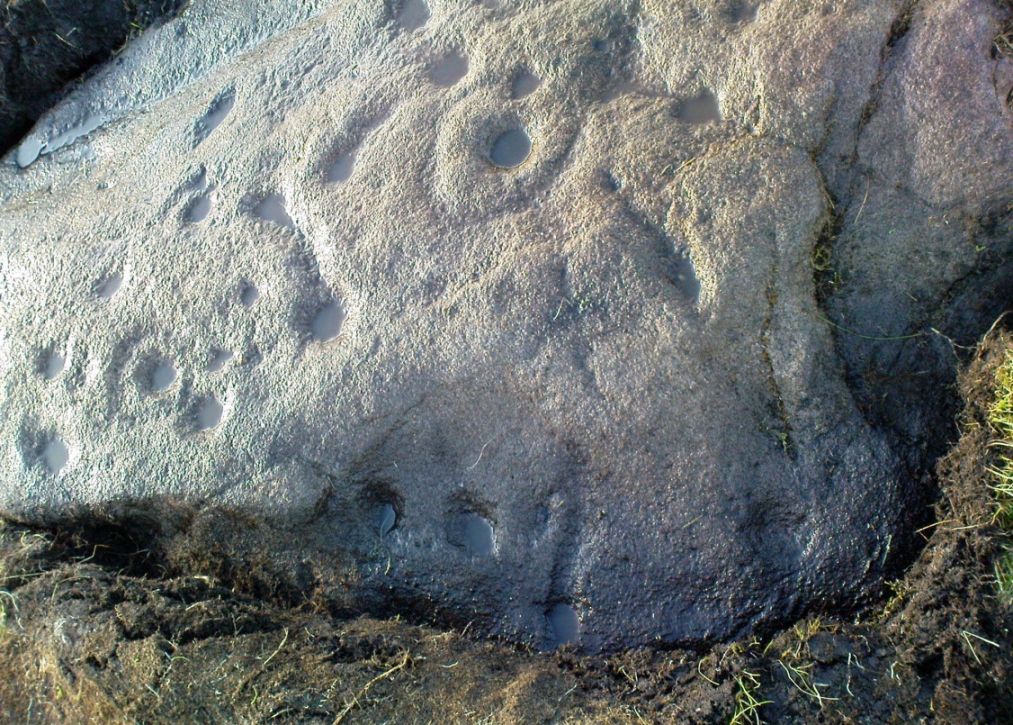
Within five minutes we came across a couple of previously unrecorded cup-marked stones, of simple design, right in line with the cairn circle. As we walked around this spot, then headed back in the direction of the circle, a cluster of small stones were noticed on the slope. One had what looked like a single cup-marking near its edge, but the rest of the rock was completely covered in vegetation. Paul Hornby and Michala Potts had, by now, already found several other previously unrecorded cup-marked stones close by; but as I carefully rolled back the vegetation at the edge of this particular rock, cups-and-rings and carved lines seemed to be covering most of its surface. It was a good one!
Face on the Fraggle Rock
We called it the Fraggle Rock after noticing that when you look at the stone from one end, the two main cup-and-rings are likes two large eyes carved above a large natural down-turning ‘mouth’ feature, similar to some of the creatures’ faces on the muppets or the similar kid’s TV show, Fraggle Rock! (sad aren’t we!?) The photo here shows you what we mean.
The primary design consists of at least 3 cup-and-rings, 2 partial cup-and-rings, 28 cups and several carved lines along which some cup-markings are linked to others. The most notable of the carved lines is the longest (barely visible in the photos), running from a single cup-mark at the southernmost rounded end of the stone, almost straight and parallel with a natural ridge or dip along the rock, until it meets the largest of the cup-and-rings (one of the eyes on the Fraggle’s face!). Don’t ask me why, but for some reason this long faint line seemed the most perplexing element of the carving.
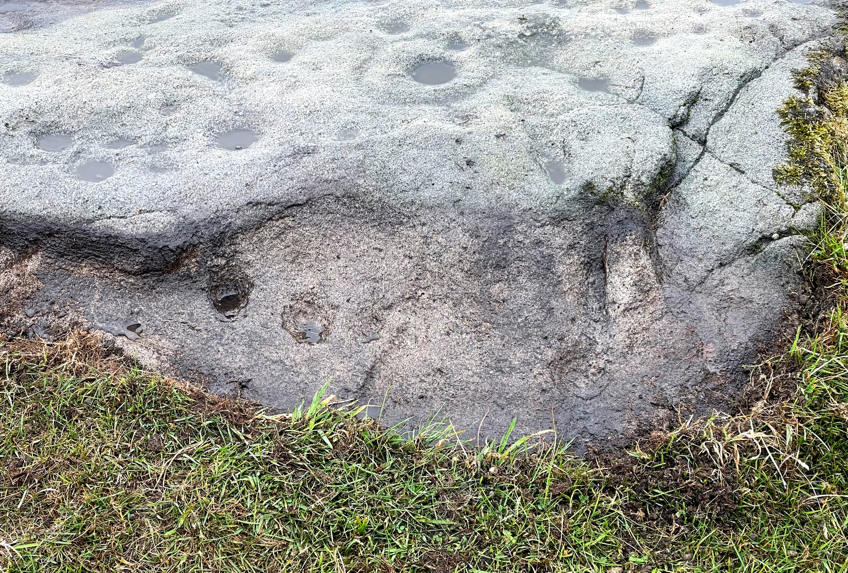
Eastern edge with low cupsCup-marks on rock edge
Most of the design is carved on the upper face of the stone, but a small part of the rock dips into the ground on its eastern side and a small group of cups and a single carved line, in a very good state of preservation, are etched right at the edge of the stone. Unusual. Another faint cup-and-ring is less than 100 yards west; and a fascinating cup-and-lines stone, with at least four long carved ridges running like hair from the top of the stone into the Earth, is a short distance to the north. A number of others are in this and adjacent fields.
One of the first photos, just as the mud had been cleared
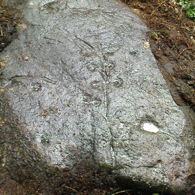
This carved stone was rediscovered by Michala Potts on the rainy afternoon of August 26, 2011, on a Northern Antiquarian excursion to explore some of the cup-and-rings on Ilkley Moor. The entire stone was totally covered in soil and leaves, and Michala spent some considerable time carefully clearing the dead vegetation to unveil the carvings beneath.
Close-up of cups & scars
This carving has at least 12 cup-marks on its slightly inclined surface, with several artificial carved lines and some that are obviously geophysical in origin. (we really could do with a geologist with a cup-and-ring fetish to accompany us on some of our outings!) But the main feature of this carving — as the photos here illustrate — appears to be the natural crack that runs up through the middle of the stone, either side of which have been etched a number of cup-markings attached by small lines or ‘branches’, giving the distinct impression of a tree. Whether this was a deliberate artistic feature (a tree), or just another Rorscharch response to non-linear systems on our behalf (more probable), we’ll never know. On the moors northeast of here on the other side of the Wharfe valley, the Tree of Life Stone acquired a similar association due to its design; but this Ilkley design, sadly, aint quite as good as the one on Askwith Moor.
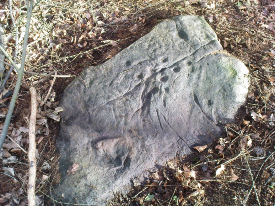
Tree Stone, showing modern industrial scars
There are some puzzles on this stone aswell. Other lines scar the rock which are definitely man-made, but they are of a different nature and age. The marks have been scarred by more modern metal tools, or were caused by heavy metal machinery that have rested on the rock at some time in the not-too-distant past. You can see the curved deep scratches in the photo here to the right. It seems likely that when the modern houses were built straight across and above here, this cup-marking was damaged by the workers — although they didn’t know it was here as the stone had not been catalogued by the Ilkley archaeologists. But there’s also another peculiar feature on this stone. Someone a century or two ago also carved other fainter features into the stone, seemingly lettering, on the northeast edge of the rock. They can be seen faintly on the second photo, above.
Go west out of Dunfermline on the A994 till you hit the Torryburn roundabout, taking the A985 Kincardine road. Barely a half-mile along, stop at the first parking lay-by at the roadside – and there, over the barbed wire fence, you’ll see your standing stones right in front of you.
Archaeology & History
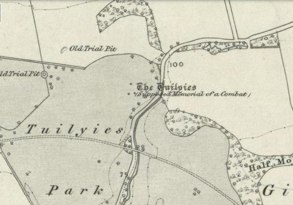
The Tuilyies standing stones
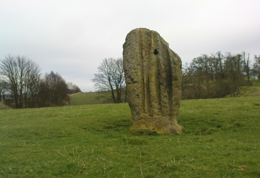
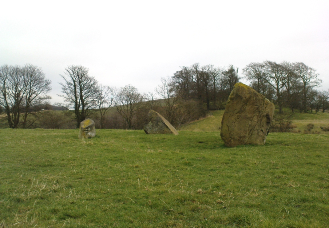
Overlooking the northern shores of the Firth of Forth is this fascinating group of standing stones which, old lore told, was once an old stone circle. You can see what they meant. The Tuilyies consists of a small group of three stones, between 3 and 7 feet tall, arranged in the form of a scalene triangle; and about 20 yards away stands the more impressive outlying 8 foot tall upright stone, somewhat akin to a petrified ancestor, with both natural and man-made cup-markings on at least two sides of its slim body. This outlying stone is of a very different character to that of its close neighbours—and a different type of stone as well—and is very similar in both size and appearance to the Robin Hood Stone at Allerton, near Liverpool. Curious…
The east-facing cup-marked Tuilyies stoneNatural ridges on its west-face
Whether the stones here were part of a stone circle we don’t know for sure. It was suggested as such in 1793 and Aubrey Burl (2000) includes them in his primary survey, but we have little evidence to prove as such nowadays. The parish of Torryburn not only had to contend with industrial agriculture knocking down any stones that may once have stood here, but in the 17th century the village also had to tolerate the psychiatric delusions of one reverend Allan Logan: one of the many deranged priests who saw witchcraft and demons in everything natural or animistic, persecuting local people for their old traditions, herbalism and peasant-lore. (Beveridge 1885; Cunningham 1902; Webster 1820, etc) These old stones were unlikely not to have received his depraved attention. But thankfully, some remain standing…
The Tuilyies seem to have been described first of all in the 1793 Old Statistical Account of Scotland—and in that narrative we find one of the earliest descriptions of cup-markings. It told that,
“In a pretty extensive plain field NE of the village of Torryburn, there is a flat stone, raised upon one end, of a shape nearly oblong and measuring, from the surface to the top, about 8 feet, and about 4½ in breadth, Round the edge of it there is a deep circle, and on each of the sides a number of ridges, all of which wear the appearance of art and antiquity. At about 18 or 20 paces from this stone, there is a number of smaller ones, which, from their present position, seemed to have formed part of a circle.”
Many years were to pass before these old stones heard from the men of words again. This time it was the renaissance of cup-and-ring designs that brought them back to light, when Sir James Simpson (1866), in his massive precursory essay to British Archaic Sculpturings (1867) talked about them:
“The stone at Torrie, Fifeshire…is a flattened sandstone flag, deeply guttered in longitudinal lines, and presenting cup- markings on its eastern side. It has been attempted to be made “a holed stone,” like (the) this block at Ballymeanoch (Argyll), but the artificially splayed perforations from the opposite sides do not meet in the middle. About fifty paces from it are the remains of a small circle of stones.”
The triangle of standing stones
Unusually, J. Romilly Allen only mentioned the stones in passing, simply repeating Simpson’s earlier words. Even local historians gave the site scant attention. In David Beveridge’s (1885) magnum opus he gave only a brief mention of the stones; and A.S. Cunningham (1902) did likewise. Thankfully after a visit to the stones by the Royal Commission lads in May 1925, a more detailed description was given. They wrote:
“The site of the cup-marked standing stone…is a plateau, 150 feet above sea level, in a field on Torrie Estate about half a mile to the northeast of the village of Torryburn, and on the north side of the drive to Torrie House. At a distance of 60 feet from it are three huge boulders, and the four are said to be the remains of a circle, although that idea is not borne out by their present disposition.
“The cup-marked stone rises to a height of 8 feet above the ground and has its narrow faces to the north-east and south-west. It is of irregular form, narrowing somewhat at 7 inches from the base, expanding outwards at the middle, and contracting again to a roughly convex top. On the east face the lower portion is covered with cup-marks. which vary from 1½ to 5 inches in diameter and from 1½ to 2 inches in depth. At a height of 6 feet from ground level, in the south-west angle of the stone, is a cavity 7 inches in depth, while there is a similar cavity of like depth opposite to it on the west face. The stone is also marked on the east and west faces, as well as on the top and down the narrow sides, with a series of perpendicular grooves of varying depth, but all these channels are due to weathering. Its measurements are: north face, 1 foot 3 inches; south face, 1 foot 4 inches; east face, 4 feet 4 inches; west face, 4 feet 3 inches; girth at base, 10 feet 8 inches; at 7 inches up, 8 feet 10 inches; at middle, 10 feet 5 inches.
“The three other boulders are set in the form of a triangle immediately to the south of this cup-marked stone, at intervals of 12, 15 and 16 feet apart. One has evidently fallen from an upright position and now lies with its major axis north and south. None of the three shows any markings. They are of whinstone, while the cup-marked standing stone is of grey sandstone.”
But as for the lack of cup-markings on the outlying smaller stones, when Ron Morris (1973) examined the site in the ’70s, he found what seemed to be some cup-marks on the largest of the group of three stones, as shown in the photos. On this he reported,
“25yds S of the well-known cup-marked standing stone are 3 large boulders. The W of these, measuring 7′ x 4½’ x 3½’ high, bears on its slightly W-sloping top surface 7 cups cup to 2″ diameter and ½” deep.”
When I visited the site the other day, these were difficult to see—cos as the photos here show, Nature gave us a bittova dark grey day and such carvings are notoriously temperamental when weather conditions aren’t to the stone’s liking!
Folklore
The Old Statistical Account of 1793 told that the stones were supposed to have “been the scene of a battle in some former period, and these stones…mark the graves of some of the chiefs, who had fallen in the engagement.” The lore was echoed in David Beveridge’s (1885) huge local history work, where he informed the reader that many standing stones along the Forth,
“are all connected with the Danish incursions. One specially may be mentioned, standing near Torryburn, the parish adjoining Culross, in a field which is still known by the name of the Tuilzie, or Battle Park.”
Morris, Ronald W.B., “Torryburn, Torry – Cup-Marked Rock’, in Discovery & Excavation in Scotland, 1973.
Royal Commission on the Ancient & Historical Monuments, Scotland, Inventory of Monuments and Constructions in the Counties of Fife, Kinross and Clackmannan, HMSO: Edinburgh 1933.
Simpson, James, Archaic Sculpturings of Cups, Circles, etc., Upon Stones and Rocks in Scotland, England and other Countries, Edmonston & Douglas: Edinburgh 1867.
Webster, David, A Collection of Rare and Curious Tracts on Witchcraft and Second Sight, D. Webster: Edinburgh 1820.
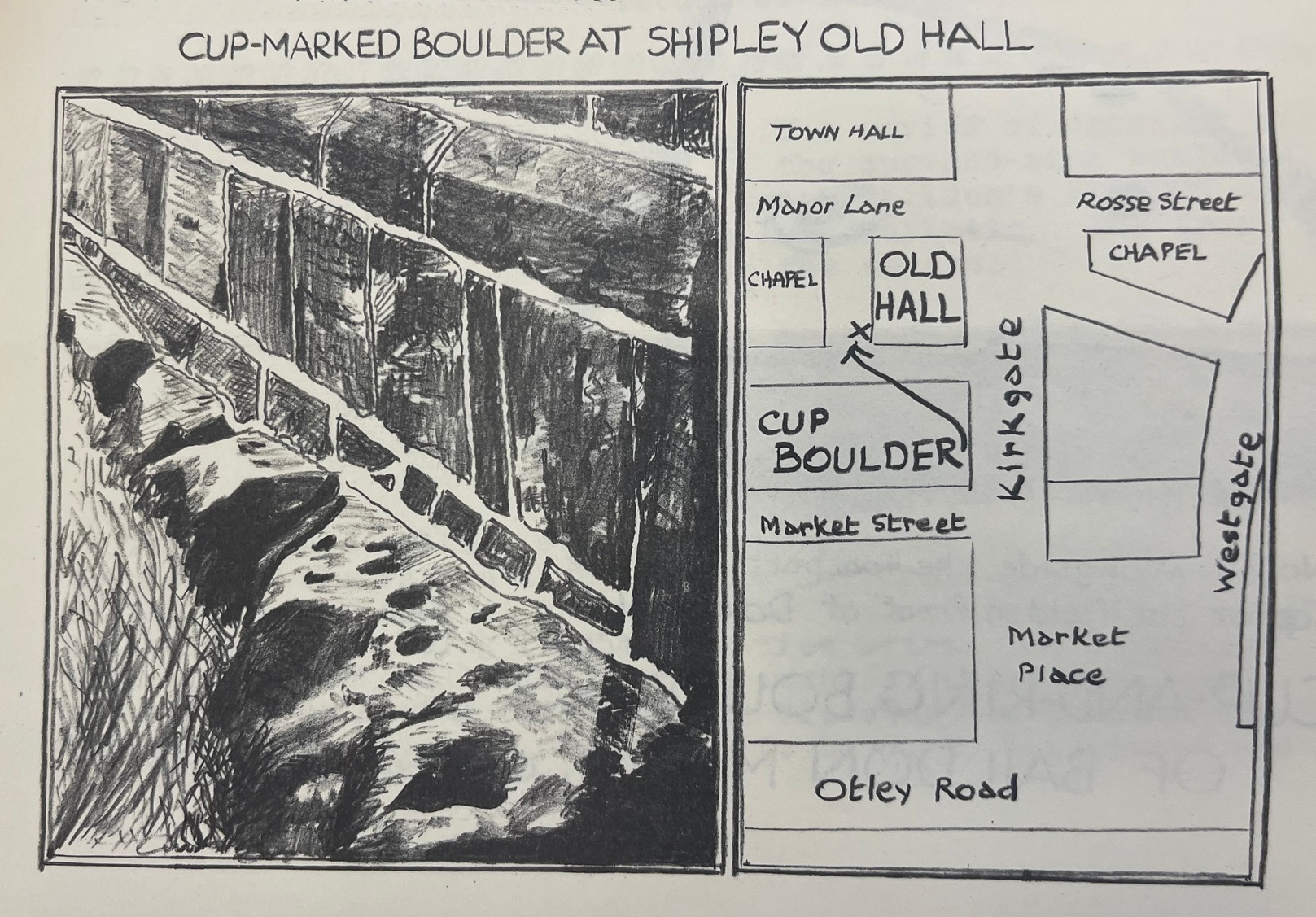
From Shipley town centre open market, take the Kirkgate road up to Saltaire, past the old town hall. On the other side of the road take the little path into the Bowling Club, in the trees (if you hit the church you’ve gone too far). Once standing in front of the bowling green itself, you need to walk along the left-side path. Two-thirds of the way down, now laid in the ivy-covered area below the old quarry face, you’ll find what you’re looking for.
Archaeology & History
I remember first seeking out this carving when I was still at school and wondering how the hell it got here – and believed it to be a fallen standing stone at the time! It seems that the stone was cut and readied for use as a gatepost instead, at some time long ago.
Close-up showing cups & linesIn its previous locale
The curious cup-marked stone has travelled about a bit, somehow. Formerly at the edge of a field in the grounds of Bradford Grammar School 3 miles away (at SE 1523 3583), the fella was then built into the wall of the now-demolished Shipley Old Hall, before reaching its present resting place at the edge of the bowling green. Consisting of around 16 cup-markings with carved lines seeming to link them here and there, it was first mentioned by the late great Sydney Jackson (1955) in an early edition of the Bradford Archaeology Journal. The carving was recently included in the Boughey & Vickerman (2003) survey, where they described it as,
“Medium-sized fairly smooth grit rock with coarse line down top, probably natural, evidence of quarrying on edge. Sixteen or seventeen cups, one with a groove out has a deeper cut within it and twelve of the others are linked in pairs by short grooves. This has been interpreted as feathering for quarrying, but the grooves are across the line of likely split, rather than along it.”
And for those of you who live nearby: if you check this out, see if you can locate an earthfast boulder near here which I recall having a cluster of distinct cup-marks running on top of the rock along one side. I couldn’t find it when I looked a short while ago, it’s not in the archaeology survey lists, and it remains lost—in the heart of Shipley no less!
References:
Boughey, Keith & Vickerman, E.A., Prehistoric Rock Art of the West Riding, WYAS: Wakefield 2003.
Jackson, Sydney, “Cup-Marked Boulder, Shipley Old Hall,” in Bradford Cartwright Hall Archaeology Group Bulletin, 1:10, 1955.
From Ilkley, take the Cowpasture Road up past Cow & Calf rocks, the hotel and along the moorside. A few hundred yards further, just before the next farm-building on your right, walk up the Rushy Beck path to the top. Crossing the stream at the top, now walk diagonally south-ish into the heather for some 200 yards, a short distance before the hillside begins to rise up again onto the next ridge. Remains of this ‘enclosure’ is all around you!
Archaeology & History
When the normal moorland vegetation covers this prehistoric site, you’d barely know there was anything here apart from various rocky rises and undulations in the ground and perhaps, if you were seeking out old stuff, what would seem to be lines of stone walls bending away onto the moor. But when the heaths have been burnt back, a whole new vista unfolds itself! You see before you a fantastic, well-preserved, unexcavated prehistoric enclosure, whose origins are probably neolithic, but whose history and use stretched through the Bronze Age and into the Iron Age—and it’s not alone! East, west and south of this particular enclosure, other prehistoric walled structures are found stretching all across the landscape hereby, structurally similar and also used over very long periods in prehistory. For antiquarians and historians alike, this is a truly impressive place indeed. In all honesty, the description I give here does not do the place justice!
Northwestern section of enclosure walling
Things like ‘settlements’ and ‘enclosures’ are traditionally relegated by purist archaeologists to be little more than domestic or utilitarian sites: places where our ancestors kept cattle; or were used for defensive purposes; or lived for long periods of the year. Of course, these simple ideas are effective and true at some places; but here at Woofa Bank—in this particular enclosure—something more than just domestic activity was enacted, and over the period of many centuries by the look of things. We surmise this by the incidence of at least fifteen cup-and-ring stones being found within the enclosure itself; and at its very centre is a small standing stone, not previously recorded, that has perhaps five petroglyphs around it. The presence of such a large cluster of cup-and-ring stones close together within the enclosure would seem to suggest ritual activity.
Carved rock & central stoneClose-up of, dancing anthropomorphic figure?
One of the carvings at the centre of the enclosure (listed in the Boughey & Vickerman survey as Carving 372) has been suggested to represent a dancing human figure (the image here shows the anthropomorphic element), which it may well be. The incidence of this central stone and its surrounding petroglyphs has important magico-religious implications, relating it as a site used for creation myth narratives and repetitions (transpersonal explorations at this site may prove worthwhile). The wider extended enclosure with more petroglyphs contained inside it, suggest that additional ritual performances were enacted here; these may have had something to do with the cluster of prehistoric tombs scattered on the moorland plain 100 yards to the west, but we might never know.
Easternmost standing stone
It seems that the walled enclosure itself was constructed around the earlier cup-and-ring stones, probably many centuries later—but we need excavations here to give us more precise details. Much of the enclosure walling itself has the hallmarks of being late Bronze Age to Iron Age, whilst we know that prehistoric rock art can date back into the neolithic period; and from this period Eric Cowling (1946) reported that, at Woofa Bank, “at the western end of the ridge,” just above this enclosure, a neolithic flint site existed.
Cowling’s 1946 plan
Cowling (1946) himself was one of very few archaeologists to even mention this impressive site, in a section exploring the “Iron Age” sites along Green Crag Slack at the eastern end of Ilkley Moor. He wrote:
“At the other end of the site under the shadow of Woofa Bank and near the source of the Rushy Beck, is another D-shaped enclosure apparently unfinished. The plan is of a circle with a flattened side and does not exceed twenty-four yards across in any direction. Here the enclosing wall shows five or six courses at the lower end side and a simple entrance to the west.”
Western entrance to enclosureStone marking eastern entrance
Though Cowling’s measurements are way out! The enclosure itself is much larger than he describes. For the most part, three-quarters of it give the impression of it being a large oval shape, but the design and outline of the walling changes on its southeastern side and kinks inward, in an arc, to eventually meet the walling in the middle eastern section. Its entire circumference measures approximately 220 yards all the way round; it is 65 yards across east-west; and about 61 yards north-south. The average height of the main walling is between 2-3 feet tall, and is made up of many large rocks, some of them positioned upright as standing stones, all packed together with earth and countless thousands of smaller stones. The walling itself is between 2-3 yards wide in many places and has two main entrances: one near the middle of the western wall and the other almost opposite to the east. The eastern entrance is marked by a standing stone between 3-4 feet tall. No gaps are visible at all on the northern curved section of the enclosure. On the overgrown southern edges, not all of the walling is visible and much of it is overgrown. On the whole it’s still very much as Cowling found it, with the arc of walling in this part of the enclosure difficult to make out clearly. There is also another line of walling that runs off to the east, beyond the main enclosure itself.
Carved rock in western wall
The clearer, more visible western line of walling, running south of the entrance on that side, has a large singular cup-and-ring stone laid right along its axis (carving 366 in the Boughey & Vickerman [2003] survey), a short distance before the walling changes direction east-west and runs along the bottom of the slope.
Folklore
Tradition tells that the tribal people from this site were involved in a battle with the Romans along this moorland plain.
References:
Bennett, Paul, The Old Stones of Elmet, Capall Bann: Chieveley 2001.
Boughey, Keith & Vickerman, E.A., Prehistoric Rock Art of the West Riding, WYAS: Wakefield 2003.
Cowling, Eric T., Rombald’s Way, William Walker: Otley 1946.
Eliade, Mircea, Images and Symbols, Harvill Press: London 1961.
Hedges, John (ed.), The Carved Rocks on Rombalds Moor, WYMCC: Wakefield 1986.
Size, Nicholas, The Haunted Moor, William Walker: Otley 1934.
Very troublesome for so little a stone. But to the nutters or climbers who enjoy a good bimble: if you’re coming on the A91 from Tillycoultry take the dirt-track up to Harviestoun, but if you’re coming from Dollar, take the dirt-track up past Belmont House – either way, keep walking till you get to Kennel Cottage. Walk past here and into the woods, then follow the burn (stream) uphill. It’s a steep climb, with waterfalls and mossy rocks. Once out of the woodland, keep following the stream. Several hundred yards uphill, you’ll pass a large rounded hillock on your left. Keep walking up the stream for another 200 yards, then walk to the right of the stream for about 100 yards. You’re damn close!
Archaeology & History
White Stane on the 1819 map
An obscure and little known site outside of the Ochils region, this stone seems to have been described for the first time in 1769 – though local people would obviously have known of its presence and mythic history centuries before this. It was then shown on the 1819 Plan of The Estates of Harviestoun and Castle Campbell, as shown here. The White Stane is a rounded quartz block about four feet long in the grasses, laid down and hard to find, it would have been impressive had it stood upright – which it may have done in ages not so long ago – in which case we would have had a shining standing stone on the edge of the steep slope halfway up the mountain. A curious ‘D’-shaped carving that seems to be etched on the top of the rock may simply be one of Nature’s simulacra.
The White Stane, looking south
When I arrived at the stone – after taking a typically circuitous bimble up the hillsides, and passing a variety of archaeological relics on the slopes east of the burn – the view was outstanding, looking some 60 miles south into the distant peaks of the Scottish Lowlands, with the sun casting itself over the entire landscape. The quartz rock by my side was gleaming brightly in the fresh daylight. Sitting down by its side, the cold wind cutting over us, a quietude befell the place and, and as I relaxed by its side, fell into a sleep for an hour or so. All was quiet and still in both mind and heart at the stone – then when I came round, I realised the sun was going down and thought it best to get off the mountains before dark!
In Angus Watson’s (1995) survey he told us,
“The 1860 OS Name Book says this is something of a mixture of whinstone and white marble, that the local tradition was that it had been erected to commemorate a battle between Wallace and the English, and that there was “no doubt whatsoever” that it was ‘druidical’!”
Watson also informs us that the name of the rock – Tom baird – is from the Gaelic, meaning the “bard’s knoll”. However, Bruce Baillie (1998) would have it that the The White Stone of Tam Baird,
“has possibly been derived from the Gaelic Tam a Bhaird, ‘the knoll of the enclosure.’”
And there is a large five-sided enclosure on the ridge of Dollar Hill, but that’s quite some distance away and would have little bearing on the naming of this quartz stone.
References:
Baillie, Bruce, History of Dollar, DMT: Dollar 1998.
Watson, Angus, The Ochils: Placenames, History, Tradition, PKDC: Perth 1995.
Acknowledgements: Huge thanks to Marion Woolley for directing us to the 1819 Estate map!
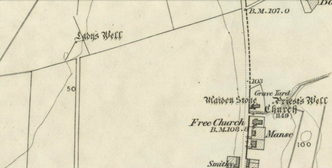
My initial thoughts about this holy well, was that it had been destroyed—but thankfully I was wrong. It had been intruded upon by roadworks along the B9140, with the original water source affected, but it was re-routed and can still be found below the south-side of the main road. It was highlighted on the 1866 Ordnance Survey map of the area When the Royal Commission (1933) lads visited the site in 1927 they told that,
“It has no features of special interest. It is 4′ in diameter, but is so much filled up with stones and debris that it is now not more than 2′ deep.”
The site was mentioned in Ruth & Frank Morris’ (1982) survey, but with no additional information. I’ve not been able to find out whether the ‘lady’ of this well was a saintly woman of religious importance, or just one of us commoners! Does anyone know?
Royal Commission on the Ancient & Historical Monuments, Scotland, Inventory of Monuments and Constructions in the Counties of Fife, Kinross and Clackmannan, HMSO: Edinburgh 1933.
Balbirnie stone circle – with Marion checking it out!
Take the A92 road running north out of Glenrothes towards Freuchie and, after a couple of miles out of town, you’ll hit the B969 road on your left. Across from here on the other side of the road, you’ve just passed a small B-road that takes you to Markinch. That’s where you need to be! Go along there for less than 100 yards and turn first right, swerving along the tree-lined road for 200 yards or so. Watch out, just before the first house on your left, for a footpath which leads into the woods. Walk down it, barely 10 yards!
Archaeology & History
This is a lovely megalithic ring in a lovely setting – albeit a new one. The circle was originally positioned some 125 yards northwest of here and would have been destroyed, but was thankfully reconstructed by Fife Council before road-widening of the A92 was done. And the job’s a good one! But as Burl (2005) tells, this wasn’t the first time Balbirnie had been threatened with damage:
The southeast stones & cistsBalbirnie from the roadside, looking SE
“With some stones removed in the eighteenth century, dug into in 1883 when bones and sherds were found, damaged by trees, it was finally excavated and restored in 1970-71,” before the main road was built. Thankfully it’s still here – and an excellent stone circle it is! However, the reconstructed site here doesn’t show the circle in its entirety. Originally there were ten standing stones making up the ring, as opposed to the seven you can see today.
The site was built amidst the scatter of other larger, and once more impressive, mythically important monuments than the circle – but it’s as likely that the circle added more to the sacred dimensions of the region as a whole when it first came to be built. For on the other side of the A92 we can still see the denuded remains of the Balfarg Riding School Henge, with imitations of its internal upright posts resurrected into position to give an idea of what once stood inside the sacred enclosure. And then about 200 yards west of that, the gigantic Balfarg Henge is impressively surrounded by a modern housing estate, built with the henge in mind, with its outlying megaliths and internal level surface area graciously intact. It’s a truly impressive prehistoric area all round, although the Balbirnie stone circle was built some considerable time after the two henges had been done, many centuries later…
Before the circle was moved, the consensus profile of the site was that given by the Royal Commission (1933) lads following their visit here in June 1925, when they told it looked like this:
Royal Commission ground-plan, c.1933
“At the southern end of a small wood on the east side of the main road from Kirkcaldy to Falkland, about 180 yards south of Balbirnie Lodge, are the remains of a large circular cairn and of the setting of standing stones by which it was once surrounded… The circle, which has had a diameter of some 48 feet, has been composed of sandstone boulders. Four of these are still in place, but one other on the southeast has been slightly displaced, while against the stone on the northeast lie two large boulders, which apparently have been transferred to this position. Any other stones that may once have existed have been removed or destroyed. The greatest height above ground of any of those that survive is 5 feet 6 inches, while one, which rises no more than 2 feet, measures in circumference as much as 9 feet 9 inches at the base. The cairn itself seems to have been broken into at two points. No record of these excavations appears to be extant, but a number of fragments of cinerary urns from the site are preserved in the National Museum. These indicate that, as might have been inferred from its general character, the monument was sepulchral and dates from the Bronze Age.”
Sepulchral indeed. When the stone circle was excavated at the beginning of the 1970s by J.N.G. Ritchie (1974) and his mates, it was discovered this was a primary function of the site. As Burl (2000) wrote:
“At Balbirnie patches of cremated bone lay underneath some circle-stones. Whatever the ceremonies here they were interrupted when the site was converted into a cemetery. Four or five cists associated with a late beaker and a jet button were constructed within the ring. The date of about 1650 BC came from wood alongside the beaker. Stretches of low walling were put up between the stones forming a continuous barrier…analogous to the embanked stone circles elsewhere in Britain that seem generally to belong to a period in the mid-second millennium… But the first cists did not long remain undisturbed and were seemingly rifled when later cists were built that contained the cremations of women and children… One of these later cists held a food-vessel and a flint knife.
“The stone circle was further abused. A low cairn was piled over all the cists. Sherds of deliberately broken urns, one with barley impressions, were scattered amongst the boulders, intermingled with small coagulations of burnt human bone. This last phase at Balbirnie occurred late in the second millennium BC, for a C-14 determination of…1200 to 900 BC came from the land surface that had built up within the ring during the centuries while the stone circle remained open to the weather.”
Measuring 49 feet across at the widest, this flattened ellipse also possessed a curious rectangular section of laid stone, near the middle of this circle, almost ‘Roman-road’ like in appearance and covering about a quarter of the internal arena. It’s visible today at the reconstructed site and looks almost intrusive! Measuring some 11 feet by 9 feet, the flat stone surface has been suggested as a place where corpses were rested.
Also found within two of the tombs inside the circle were the cup-and-ring marked stones of Balbirnie 1 and Balbirnie 2, showing yet again the relationship that some of these carvings have with spirits of the dead.
References:
Burl, Aubrey, “Intimations of Numeracy in the Neolithic and Bronze Age Societies of the British Isles (c.3200-1200 BC),” in Archaeological Journal, volume 133, 1976.
Burl, Aubrey, Rings of Stone, BCA: London 1979.
Burl, Aubrey, The Stone Circles of Britain, Ireland and Brittany, Yale University Press 2000.
Burl, Aubrey, A Guide to the Stone Circles of Britain, Ireland and Brittany, Yale University Press 2005.
Denston, C.B., “The Cremated Remains from Balbirnie, Fife,” in Archaeological Journal, volume 131, 1974.
Ritchie, J.N.G., “Excavation of the Stone Circle and Cairn at Balbirnie, Fife,” in Archaeological Journal, volume 131, 1974.
Royal Commission on the Ancient & Historical Monuments, Scotland, Inventory of Monuments and Constructions in the Counties of Fife, Kinross and Clackmannan, HMSO: Edinburgh 1933.
Acknowledgements: Huge thanks to Marion Woolley for getting us out to see this and the related neolithic monuments. Cheers m’ dears!