Park up at the Nick of Pendle and follow directions to the Devil’s Apronful of Stones, but about halfway along the path, bear to the right along a swerving footpath which eventually takes you to another guiding cairn. On the OS-maps there’s the Chartist’s Well 100 yards due west of this old overgrown tomb.
Archaeology & History
The much-overgrown Lower Apronful cairn
Seemingly excluded from all previous archaeological surveys, this is a very large structure indeed. Crowned with a small modern cairn on its top marking a small footpath crossing the site, this very large cairn-like structure is about four feet tall at the highest. I first came across it at the end of August, 2006, after going through some folklore records which then led to exploring the area in the hope that there might be some archaeological ruins in the region — and we weren’t to be disappointed!
Outline of extended monument
This giant cairn structure is larger than the denuded remains of the Devil’s Apronful cairn that can be seen a few hundred yards further uphill, but is almost entirely overgrown with grasses. It measures at least 31 yards (east-west) by 29 yards (north-south) and is just like an overgrown Little Skirtful of Stones on Burley Moor. Parts of its eastern side have been dislodged and the main rock structure is plainly visible where the vegetation has come away. A ringed embankment is also very clear, mainly on the north and eastern sides of this large structure (as one of the photos here shows), but on the whole it is overgrown and ruinous. It’s a brilliant spot though and sorely needs some proper archaeological attention. In the event that this site aint a prehistoric cairn, please lemme know so I can delete it from TNA.
The old Scottish folklorist, A.A. MacGregor, described this legendary rock, “by the Bridge of Luib, on the River Don,” in his classic Peat Fire Flame. (1937) One of the numerous ‘holed stones,’ it was one of countless rocks in our isles imbued with animistic spirit essence, akin to similar rocks found in all of the other cultures in the world. MacGregor told how,
“It happened that a man summoned to the death-bed of a relative came to this crossing-place just after torrential floods had carried away the bridge. When he was on the point of abandoning all hope of reaching the opposite bank, a tall man appeared from nowhere and volunteered to carry him across. The distracted homecomer accepted the assistance proffered. But, when he and his carrier reached mid-river, the latter reverted to the form of the river kelpie and endeavoured to drag him down to the river’s bed. The victim managed to escape. As he scrambled to the bank, the infuriated kelpie hurled after him the huge boulder that to this day goes by the name of the Kelpie’s Stane.”
But the stone was also known to possess healing and magickal properties, as evidenced from MacPherson’s (1929) chronicle, which told:
“Somewhere near Dinnet was the Kelpie Stone. Childless women passed through its 18 inch (46cm) hole to concieve. A noble lady performed the task to no avail; only when she repeated it in the same direction as the river flow did the charm work.”
Close by are several other intriguing place-names which may at some time have had some archaeo-mythic relevance to this legendary rock. On the hill above is the old Carn Lian; the water course nearby is the Allt na Ciste; but most intriguingly we find the Bog of the Old Woman, or the Moine Cailleach a half-mile to the east.
References:
MacGregor, Alisdair Alpin, The Peat-Fire Flame, Ettrick Press: Edinburgh 1937.
McPherson, Joseph M., Primitive Beliefs in the North-East of Scotland, Longmans, Green & Co: London 1929.
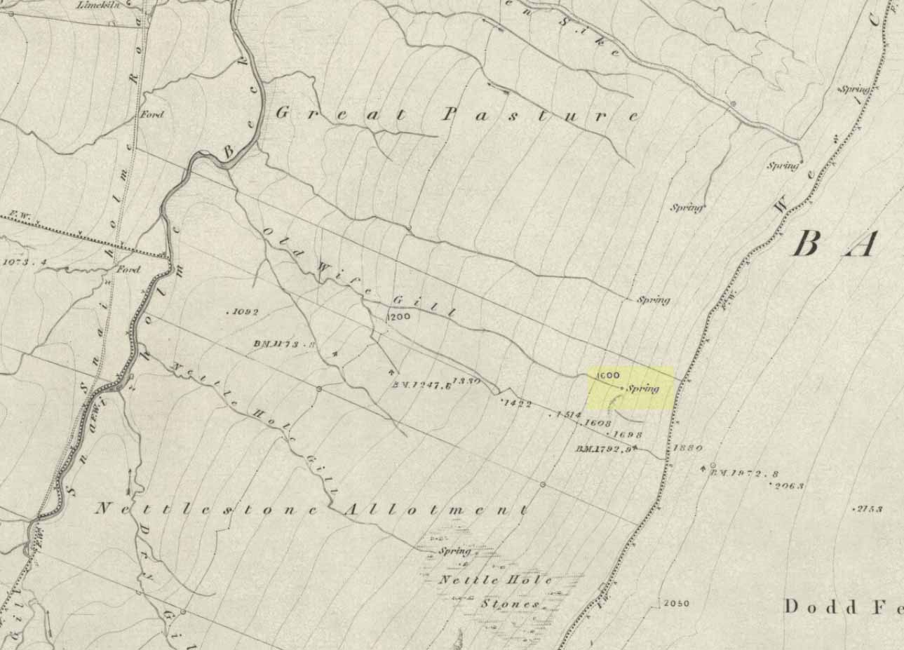
The ‘Spring’ atop of Old Wifes Gill, on 1853 OS-map
From Hawes, take the B6255 road west-ish to Ribblehead, but only for 1km, where there’s the Cam Road track on your left. Walk on here, and keep going till you’re looking down the valley past the very last house (those of you who wanna take the Pennine Way from Hawes will end up in the same place). It’s one of the springs down the steep slope on your right! (check the attached link to the OS-map to work out which one you’re heading for)
Archaeology & History
Apart from a singular mention in place-name records, I have found no historical information (yet!) about this old water supply. It was one of the great sites of the cailleach in our Yorkshire hills: a truly ancient and heathen place, all but forgotten and lost in the mythic landscape of our past. And it’s a bittova dodgy spot getting right up to her down the rather steep hilly slope — but it’s truly well worth the trek!
The Old Wife’s Spring
When I first visited this place, we took off from Cam Fell’s western side and ambled up the tops until the land gave us the beauty of Snaizeholme valley, which had us stopping, dreaming and wanting more as we sought to find this forgotten well. Most of you would probably come from the easier side of Hawes and walk along the path on the southern-side of the valley, or p’raps even wander up Snaizeholme valley itself – but I’d recommend a walk along the tops. Tis much much better!
If you’ve got the 1:25,000-scale OS-map, you’ll see the ‘Old Wife’s Gill’ running down the hillside. Get over the wall by the track-side and stagger down the steep slope. You’ll pass a small spring about 70 yards down – but this aint the one (though I think originally the Old Wife came from much further up Dodd Fell itself). You’ve got another 75 yards to go down before you get to the main spring – but if you’re old and fragile, unfit or fat, you’ll struggle like hell here!
The waters emerge from this very steep slope, surrounded by plenty of thorns and thistles, on a part of the hill where the land itself is slowly coming away. After a long dry-spell no doubt, this might be a little more secure; but when we came here She’d been raining on-and-off like hell and the waters were a-plenty. It’s difficult to actually locate the exact spot where the water first appears – but like I said, it seems to have, long ago, come from much further up the hill. As the photos show, the water’s nice n’ clear, good-tasting, and then continues along its downward stream – known as the Old Wife’s Gill – until hitting the small river at the valley bottom.
The Old Wife’s Spring from below
The other site in this valley which assures us of the cailleach’s validity comes from the place-name a few hundred yards further up the valley, seemingly giving source to the valley river herself: a Lady Spring or well, whose form once emerged close to the gate of the Cold Well close by. The third part of the cailleach’s form – the maiden or virginal – has been lost as far as local myth and literary records go. But I’ve gotta come here a few more times to get an idea as to where this ‘lost’ water-source originally appeared. A number of streams run off the hills here into the curiously-named Snaizeholme valley (which etymologists assign to nowt more than a “place where twigs are” – which seems nonsensical), and as there’s been very little by way of human habitation screwing the land up, there’s a damn good chance we’ll find and recover the mythic history of the landscape here after a few more treks and dreams…
Other sites of similar mythic relevance which need checking include Carlow Hill (SD 770 858)at Stonehouse, Dentdale; and the great valley of Carlin Gill on the North Yorkshire/Cumbria border (SD 634 993 – Gambles 1995:39).
Take the road from Shipley to Guiseley, the A6038, past the turn-off to Esholt, until you get to the top of what’s locally known as Hollins Hill. There’s a small farm-track to your leftand in the woodland here you’ll find the rocky outcrop.
Archaeology & History
Nothing has been written about this spot, but in this large wind-and-water worn rock outcrop, with its small cave, on the top part of the rock are several faint cup-markings.
Folklore
Legend tells that a man on horseback jumped from the top of here and landed safely at Low Hall, Yeadon, 2500 yards away to the east. (probably some sort of solar lore)
References:
Gray, Johnnie, Through Airedale, from Goole to Malham, 1891.
Easy enough to get to – and a lovely place to behold for an amble! From Settle, take the B6479 road up to Horton-in-Ribblesdale (ask a local if you’re too dumb to find it!), turning right at Stainforth and up the single-track road towards Pen-y-Ghent. Keep yer eyes peeled for Rainscar – you’ve about a mile to go. If you end up at Pen-y-Ghent House you’ve gone past ’em. Turn back for 2-300 yards. It’s on the right-hand side of the road as you’re coming up, about 100 yards up the footpath.
Archaeology & History
The Giants’ Graves (after W. Bennett, YAJ 1937)
The earliest description I’ve found of this is in Terence Dunham Whitaker’s History and Antiquities of Craven (1878), where he reckoned the remains here to be of Danish origin. The same thing was professed by the southerner, archdeacon W. Boyd, who said as such to the local people hereabouts more than 100 years ago, but they thought him a bit stupid and laughed at his notions! (though it does seem that Boyd wasn’t liked locally, tending to think himself better than the local people, who told him very little of local lore and legend) Describing the remains, Whitaker said there were skeletons found in the tombs:
“The bodies have been inclosed in a sort of rude Kist vaen, consisting of limestone pitched on edge, within which they appear to have been artificially bedded in peat earth.”
But Harry Speight (1892) doubted this, saying that Whitaker never even visited the site! When he went here he told us that,
“What is left at present are a few mounds of earth, the largest, which is divided into two, and lies north and south, measures about 28 feet by 25 feet. There is another apparent grave-mound on the east side of it, and again to the north is an oblong excavation or trench, 7 feet wide and nearly 30 feet long, in which several bodies or coffins may have been deposited. Several large oblong stones lay flay upon the ground beside the graves, but these were removed a few years ago and degraded to the service of gate-posts.”
The site was excavated in June 1936 by Arthur Raistrick and W. Bennett (1937) after they had been badly damaged and the stones robbed for walling and other profane building operations. Herein were found two burial cists with fragments of human bones in each tomb. In Bennett’s short account he told:
“The site consists of a nearly circular bank, about eight feet wide, and in parts two feet high, surrounding a much disturbed area. Within the area are the remains of two cists and a number of hollows that certainly represent other similar structures. The farmer tells of the removal of more than twenty large stones from these hollows, for use as gateposts, wall throughs and drain covers.* The bank encloses an area fifty-four feet east to west…and fifty feet north to south. At the west end there is a smaller bank, roughly in form of a circular apse, extending a further thirty feet. Many large boulders and vast quantities of smaller stone are incorporated in the bank.
“Near the east end, with its axis bearing N75E, is a cist — three stones in position. This was cleared to a depth of eighteen inches, and though no floor stone was present, among the sifted soil were found (i) broken bones, including parts of humourus, axis, vertebrae, ulna, ribs and cranium, all human; (ii) five teeth — two molars, one wisdom tooth, and two incisors, which appear to represent tow individuals. Sir Arthur Keith reports that the bones submitted to his examination may represent more than one adult person, and there is also a fragment of a child’s tibia. Most of the limb bones belong to a man of medium stature… He suggests from the condition of the bones a person of the Iron Age. While this is possible with a secondary interment in the area, it is rather unlikely, as all the bones came from within the built cists, and not from the earthen part of the mound, where secondary burials would be expected.
“At the west end are two large stones, the side stones of cists or of a chamber. The ground in front of them has been excavated many years ago…and partially refilled with boulders… Within the small extension on the west a trial excavation showed eighteen inches to two feet of random boulders, and beneath them, on the old sub-soil surface, two inches of fine grey sand, with two small flints — one of them a well-worked blade. These probably pre-date the construction of the circle.
“The whole site is suggestive of a multiple cist burial mound, or even a “passage grave” type. The obvious hollows, from which many of the larger stones have been lifted, are aligned in a parallel series, along an axis N75E, directed towards the two remaining large stones at the west, which may be part of a chamber wall and not part of a cist.”
Recent archaeological analysis has suggested these may be the remains of an old chambered cairn, although there is today far too much damage that’s been done to give us an accurate portrayal of what this originally looked like. The Dawson Close prehistoric settlement is less than half-a-mile further up the ridge.
Folklore
The folklore here is simple: these are the graves of giants who lived in the valley of Littondale in ancient times.
References:
Bennett, Walter, ‘Giants’ Graves, Penyghent,’ in Yorkshire Archaeological Journal, part 131, 1937.
Boyd, W. & Shuffrey, W.A., Littondale Past and Present, Richard Jackson: Leeds 1893.
Feather, Stuart & Manby, T.G., ‘Prehistoric Chambered Tombs of the Pennines,’ in YAJ 42, 1970.
Speight, Harry, The Craven and North-West Yorkshire Highlands, Elliott Stock: London 1892.
Whitaker, Thomas Dunham, History and Antiquities of the Deanery of Craven, Joseph Dodgson: Leeds 1878 (3rd edition).
* It might be worthwhile exploring the local gateposts and walls to see if any of these covering stones had cup-and-rings carved on them, as was traditional in many parts of Yorkshire and northern England.
Going up the A99, just as your approaching Ulbster, take the left turn where the phone box is and go up the track for about a mile towards Watenan house. A few hundred yards before here, three walls meet: follow the walling to the NW, past the nearby Cairn of Get and Garrywhin Stone Rows. You’ll walk right into the fort!
Archaeology & History
This is a gigantic old hillfort, surrounded on all sides by a mass of prehistoric remains from the neolithic and Bronze Age periods. But the fort itself is mainly Iron Age. It occupies the summit of a broad ridge of land with 3, possibly 4 entrances and surrounded by bog-land. It measures 590 feet north-to-south and up to 200 feet wide at its greatest diameter. The stone walling averages some 8 feet wide around the fort and its entrances are lined with large slabs of stone.
Folklore
The local folklore writer George Sutherland (1937) told that the cliffs on the western edge of this large hillfort were haunted and under the protection of supernatural guardians. One tale he narrated told of,
“a young man (who) happened to be at Garrywhin one day. He met a mysterious stranger there. The stranger asked him to look at the cliff and to tell him if he saw anything unusual. He looked and saw nothing unusual in the cliff. The stranger then gave him a pencil with a small glass in one end…and bade him look at the cliff through the glass. He did so, and to his horror he saw a large hairy beast slowly climbing up the perpendicular face of rock as a fly would walk up a pane of glass in a window. He got frightened and fled. To his dying day he believed that the strange man and the big hairy beast were creatures not of this world.”
There is also the curious folktale about powerful whisky attached to some characters by the Garrywhin Fort!
Many years after the fort had been constructed, a man and his son came to live on the southern end of the hill. They made a living selling their own brand of whisky, and a special kind of beer to local people. Local people were perplexed as to how the two could make such drinks, as they grew no barley or any other kind of grain, so the reputation soon gathered that they used supernatural means. The two men declared simply that their drinks were made from simple plants, but kept their methods secret. But the local folk wanted to know just how they made it so strong and so ended up threatening them for their secrets.
As George Sutherland wrote:
“It was known to everyone that dealt with them that they had a cave in the face of precipice in which they did their work unseen by any eyes but their own, and in which they stored their goods. Owing to some magical contrivance, no one – apart from the old man and his son – could find the entrance into the cave. Every device that ingenuity could suggest was tried on the old man and his son to induce them to reveal their secret, but in vain. At last they threatened them with death. The old man said to them, “If I should tell you, my son would kill me for doing so; kill my son and then I shall think over the matter.” They killed his son. The old man then said to them, “Now, kill me also; no on else knows our secret, and it will die with me.” They killed him, and so the secret remained a secret.
“Every inch of the face of the precipice, and of the adjacent ground, was scrutinised and tested over and over again, but no trace of the cave, or of the heather whisky and the heather ale stored in it, was ever found.”
References:
Sutherland, George, Folklore Gleanings and Character Sketches from the Far North, John o’ Groats Journal: Wick 1937.
To get here, start from Bingley centre, go through Myrtle Park, across the river bridge and turn right at the dirt-track. Walk on & go over the old bridge/ford of Harden Beck, keeping with the track until the next set of buildings and be aware of a footpath left here. Take this and cross the golf-course, bearing SE until you reach the edge of Cottingley Woods. Take the distinct footpath into the trees & walk up the vivid moss-coloured path until you reach the level at the top where the woods become more deciduous. Here, turn left for 100 yards into the bit of woodland which has been fenced-off and walk about. You’ll find it!
Archaeology & History
Cottingley Woods Fairy Stone
This is a truly superb cup-and-ring stone which anyone into the subject must take a look at! It was first found by the old forester here, Ronald Bennett, in 1966 — ten years before the rock art student Keith Boughey (2005) mistakenly reported it to have been found “by Valerie Parkinson…in 1976.” Everything about it’s excellent — but I think the setting in woodland is what really brings it out.
The first published account and photograph of this superb carved stone seems to have been in Joe Cooper’s (1982) precursory essay on the Cottingley Fairies in an article he wrote for The Unexplained magazine in the 1980s. A few years later I included the stone in a short article on local folklore (Bennett 1988), then again much later in The Old Stones of Elmet (2001). It was curiously omitted from Boughey & Vickerman’s (2003) survey, as were the other carvings that are found very close by. Not sure why… But of the small cluster here (I’ll add the others later), this carving stands out as the best of the bunch by far! Its name has nothing to do with the Cottingley Fairy folk down town: it simply originates from my own teenage thoughts and the true ambience of the setting. Check it out!
Joe Cooper’s 1982 photoFairy Stone carving
The rock is typical millstone grit and its carved upper surface measures roughly 3 yards east-west and 2 yards north-south, sloping gently into the ground. As the photo shows, this is an elaborate design seemingly centred around two large and another smaller circular form, each enclosing a number of internal cups, ring and lines. The next time we’re over there, we’ll try get some clearly images and make a detailed drawing of the old fella! In the event that you visit here, check out the other three carvings close to this primary design — and try work out which one of the three was carved by the scouts in more modern times! Another simple cup-marked stone was recently found in the undergrowth a short distant east of this group.
Sketch of the design in 1981
Recently the carving was given attention with what’s known as photogrammetry software: this enables a more complete image of the 3-dimensional nature of objects scrutinized. In the resulting photos (which I’m unable to reproduce here due to copyright restrictions), a previously unseen long carved line was detected that runs across the middle of the larger of the two enclosing rings. Hopefully in the coming months, those with the software (can’t remember whether it’s English Heritage or Pennine Prospects who won’t allow it) might allow us to reproduce one or two of their images to enable the rest of the world to see what their images have uncovered. After all, considering that we peasants brought this carving to their attention, you’d at least hope they could repay the finds. Some of these larger organizations, despite what they may say, simply don’t swing both ways!
Folklore
In an early edition of my old Fortean archaeology rag of the 1980s, I narrated the tale of one Anne Freeman, who was walking through the woods here. When she reached the top of the woods, near some stones she heard a loud chattering and allegedly saw two tiny figures barely one-foot tall wearing red outfits and green hats in “medieval peasant dress”. Andy Roberts (1992) later repeated the tale and illustrated the carving in his Yorkshire folklore work.
In the 1960s, the old ranger Ronnie Bennett (no relative of mine) who first found these carvings, also reported that he saw little people here: “not one, but three,” as he said. Not fairies with wings, but more gnome-like.
References:
Bennett, Paul, Of Cups and Rings and Things, unpublished: Shipley 1981.
Bennett, Paul, ‘Tales of Yorkshire Faeries,’ in Earth 9, 1988.
Bennett, Paul, The Old Stones of Elmet, Capall Bann: Milverton 2001.
Boughey, Keith, “A Group of Four Cup-and-Ring-Marked Rocks at Black Hills, Cottingley Woods,” in Prehistory Research Section Bulletin, no.42, 2005.
Cooper, Joe, ‘Cottingley: At Last the Truth,’ in The Unexplained 117, 1982
Roberts, Andy, Ghosts and Legends of Yorkshire, Jarrold 1992.
This is a fine-looking monument amidst a fine piece of landscape! The site was constructed over various centuries, beginning in the Iron Age, with the earliest parts being the traces of walling on the outer edges. This first section of the fort “measures about 245m in length by a maximum of 50m in width internally,” and much of it can still be traced all along the full length and breath of the geological ridge upon which it sits. However, the timber-laced walls that stood all round the edges have, obviously, all but disintegrated. This earlier part of the fort, wrote Richard Feacham (1977),
“was superceded by a small subrectangular, now vitrified fort, about 170 feet long by 60 feet wide, and by a circular and probably vitrified dun measuring about 60 feet in diameter.”
View of the Dun (Smith 1885)Looking out from the dun
There was ample water supply for the people who may have lived on this ridged fortress, as there is still a fresh water spring on the southeast edge of the hill. And it seems pretty obvious that this fort was occupied for some considerable time into the Common Era, as material remains found amidst excavation work here at the end of the 19th century, “including metalwork of Roman date…suggests an occupation in the early first millenium AD.” (Harding 1997)
Folklore
The folklore and legends of this site (aswell as the surrounding district) are considerable, and for now I must refrain from writing all there is (it’d take me ages!). Needless to say, R. Angus Smith’s (1885) fine old history and folklore work is the source of much material. Smith told us that,
“There are many stories about it. It has been called the beginning of the kingdom of Scotland, the palace of a long race of kings; also the Halls of Selma, in which Fingal lived; the stately capital of of a Queen Hynde, having towers and halls and much civilization, with a christianity before Ireland; whilst it has also been considered to be that which the native name implies, simply the fort of the sons of Uisnach, who came from Ireland, and whose names are found all over the district, and who in the legend are reported to have come to a wild part of Alban.”
References:
Feacham, Richard, Guide to Prehistoric Scotland, Batsford: London 1977.
Harding, D.W., “Forts, Duns, Brochs and Crannogs,” in The Archaeology of Argyll (edited by Graham Ritchie[Edinburgh University Press 1997]).
Royal Commission on the Ancient & Historical Monuments, Scotland, Argyll- volume 2, HMSO: 1974.
Smith, R. Angus, Loch Etive and the Sons of Uisnach, Alexander Gardner: London & Paisley 1885.
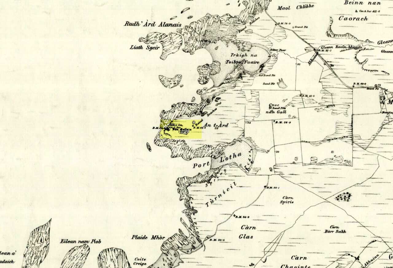
Bittova trek this one. Once on Colonsay, head out onto the B8086 road west of Scalasaig until you, past Machrins, and onto the gold course. Take the footpath across it (south), until you hit the little airstrip where you need to veer right (west) right onto the spur of the coast about 800 yards away. Your damn close!
Archaeology & History
Highlighted on the 1878 OS-map of the region, this site occupies a prominent position. Its summit is surrounded by a line of oval walling enclosing an area of about 90 square yards. There are also remains of of outer walling to the eastern and southern sides. The ‘cairn’ on the highest spot in the middle of the hillfort is a modern construction.
Folklore
The great Scottish folklorist A.A. MacGregor (1947) narrated the tale behind this denuded fort on the western edge of the island. According to the islanders who told him the tale, they alleged it Norwegian in origin, though the fortress is much older than that. MacGregor told that, “in this fort there once lived an elderly and voluptuous tyrant named Grey Somerled, who is said to have been related to the first of the Lords of the Isles.
“Grey Somerled came to Colonsay, they say, in the capacity of factor. But he neglected his duties, imposed penalties and hardships on the innocent and defenceless tenants, and generally made himself so disagreeable that at last it was decided to take revenge upon him, previous warnings having been no deterrent.
“Like Rory Mor of Dunvegan, who slept best when he was within hearing of his ‘nurse’, the waterfall, Grey Somerled was wont to be lulled to sleep by the grinding noise of a quern placed near his head. When he retired for the night, one of the servants had to turn the quern-stone by his pillow, and keep on turning it, lest he woke.
“It was recognised that any attempt to surprise Grey Somerled during daylight was foredoomed to failure. So, a plot was laid to circumvent him during the night-time. His enemies entered into a conspiracy with one of the servants that she should allow them to invade Dun Gallain after he had fallen asleep. When they arrived, one of their number relieved the woman at the quern, and proceeded to turn the stone without intermission. But he was not too skillful at the turning; and his harsh and irregular grinding soon woke the sleeper. Ere Gey Somerled had had time to consider the matter of resistance, his foes were upon him. They carried him away from Dun Gallain; and tradition in the islands of Argyll has it that, in great privation, he spent the remainder of his days in a bee-hive house of stone, situated on the farmlands of Machrins.
“One night – so the story concludes – a huge boulder from the roof of the bee-hive fell in, killing its unhappy inmate. So as to identify the spot where this tragedy happened, the islanders raised on it the cairn now indicated on the Ordnance Survey Map as Carn Shomhairle Liath – that is to say, Grey Somerled’s Cairn.”
Interestingly, there is a long-cist burial at Machrins (plus small settlement) a few hundred yards east of the fort, and excavations here found them to date from the Viking period; though the Scottish Royal Commission thought that although the “small finds associated with the burial suggest that it is Viking, the plan-form of the houses is perhaps more likely to indicate a native tradition.”
References:
MacGregor, Alasdair Alpin, The Peat-Fire Flame, Ettrick Press: Edinburgh 1947.
Royal Commission of Ancient & Historical Monuments, Scotland, Argyll – volume 5, HMSO: Edinburgh 1984.
Described in 1926 by local antiquarian and early ley-hunter, W.A. (1926), as “a fallen monolith” — this old stone is probably just a glacial erratic. Found in the churchyard of St. Mary’s, tradition tells that in ages past young girls danced twelve times around this old stone, then placed their ears upon it to hear the answers to their questions and wishes. A similar legend tells how children danced around the stone seven times on a certain day of the year to conjure up the devil. Mr Dutt thought the great rock may have been “a ley or direction stone.”
References:
Dutt, W.A., The Ancient Mark-Stones of East Anglia, Flood & Sons: Lowestoft 1926.


")

")