The Polisher, West Overton, Wiltshire

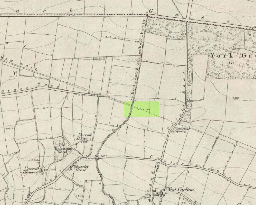
‘Standing Stone’:  OS Grid Reference – SU 12828 71508

Also Known as:

  1. OD II (Fowler)
  2. Parsons Penning Stone
  3. The Polissoir

Getting Here

The Polisher at rest

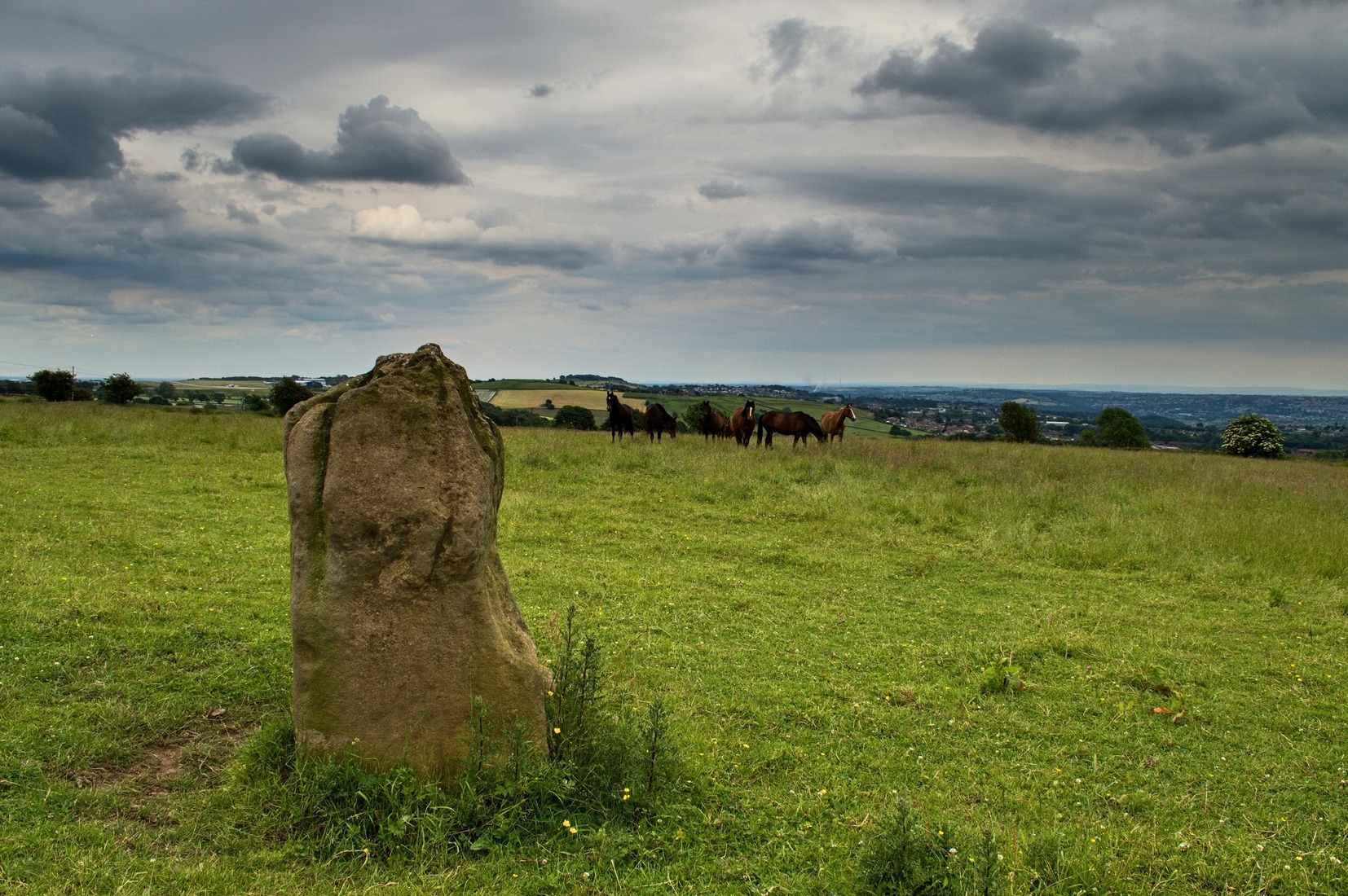
We were graciously guided to this spot by local archaeological authority, Pete Glastonbury — which is good, cos otherwise it’d have probably taken us all day to find the damn thing!  Best way to get here is out of the Avebury circle, east, up for about a mile up the Herepath or Green Street till you hit the ancient track of the Ridgeway.  Turn left and walk up the gentle slope for another 350 yards or so, then note the footpath on your right.  Go down the slope for about 150 yards, keeping your eyes peeled for the smooth rock with the slits in it, not far from the Holed Stone!

Archaeology & History

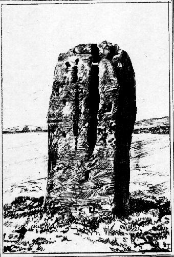
Although classified on the Wiltshire Sites & Monuments Record as an “unclassified feature,” this is one of a number of whetstones (as we call ’em up North) that feature in various settings in and around the Avebury region: literally, a rock used for sharpening axes, daggers and other metallic artifacts. First rediscovered in the spring of 1963 by a Mr Inigo Jones when he was out exploring the many rocks hereby for rare lichens and any more cup-markings like the one at nearby Fyfield Down, the site we see today is merely a long piece of stone with five or six long lines or grooves cut into the top-end, along which the ancient weapons and tools slid and cut into the rock, sharpening them.

It was thought until recently that this was the prime function of this stone; but following excavation work done here by Pete Fowler and his team in 1963, it seems that the stone actually stood upright!  Digs were made on three sides of the stone and some earlier disturbance seemed apparent:

“The material appeared to be redeposited on top of an earlier ground surface, inferentially of medieval or earlier date.  At the north end of the sarsen bench, the lip of a pit or trench was partly excavated.  It showed clearly in plan as a feature dug into the top of an undated surface level with the disturbed top of the clay-with-flints; it was filled with flinty, clayey humus similar to that through which it was cut.  In the top of that fill was a heavily weathered sarsen, c 0.6m by 0.45m, and a cluster of smaller, broken sarsen stones.  The hole was at least 0.45m deep, its bottom as excavated marked by an increase in the density of flints.  The evidence, though incomplete, suggested very strongly that the feature was part of a hole dug to take the pollisoir as an upright stone.” (my italics, Ed)

In the same dig, a medieval coin of King John (1199-1216) and the remains of a medieval horseshoe were found beneath the stone, giving Fowler and his team the notion that the stone had been split and pushed over at this period.  Consistent evidence of activity from the neolithic period onwards was expected and found here.

In Lacaille’s (1963) original description of the site, he gave a most accurate description of the dimensions of the stone and its incisions.  Highlighting its proximity to a cluster of other stones, as well as being close to a wide ditch, Lacaille’s measurements were thus:

“From 1ft (0.31m) above ground at its south end the regular surface of the sarsen slopes to the grass, its main axis being aligned about 15° west of the true north and south line.  In length the stone measures 5ft 6in (1.68m) above the grass, and 2ft 10in (0.86m) in width.

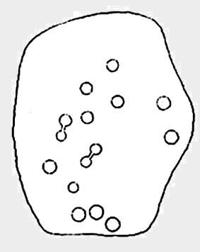
“Closely grouped in the south-eastern corner of the sarsen there are six hollows.  In plan the largest and southernmost is of long elliptical shape, 1ft 8in (0.5m) long and 9in (0.23m) at widest and 1in (0.0254m) deep.  From its wider end near the eastern long margin there protrudes a short groove.  Beside this, and curving slightly inward, there is another groove, 1¼in (0.028m) wide and ½in (0.013m) deep.  It is as long as the large basin-like cavity.  Next to it there runs one of similar length and width, but of only half the depth.  In turn, a third groove, ½in (0.013m) wide, 1ft 8in (0.5m) long, has been worn at right angles to the long edge but to a much deeper hollow than its companions.  At 2in (o.051m) to the north a lesser version of the main basin occurs.  Like this it measures 1ft 8in (0.5m) in length, but is only 2¼in (0.058m) wide and ¾in (0.016m) deep.  Vague in places over its interior length of 10in (0.25m), but attaining a maximum width of 1¼in (0.028m), a last hollowing shows faintly at both ends and nowhere deeper than 1/8in (0.0032m).”

The Polisher & its marks
Celoria & Lacaille’s 1963 drawing of the stone

It appears that this fallen standing stone was being used to sharpen knives and axes whilst it stood upright and, in all probability, as a result of this ability would have been possessed of magickal properties to our ancestors.  Metalwork was an important province of shamanism and smiths, whose practices were deeply enmeshed in the very creation of mythical cosmologies.  Hence, the simple act nowadays of sharpening metal tools onto rocks would not have been a mere profanity to the people who came and used this stone to re-empower their weapons, but would have been entwined within a magickal cosmology.  The spirit inherent in this stone would likely have been named and recognised.  Today it is forgotten…

It also seems that this standing stone was part of some ancient walling.  Aerial views clearly show it along the line of some sort of enclosure that runs down the slope, along the bottom and back up and around.  In the same stretch of this enclosure walling we find the Holed Stone a little further down the slope.  And holed stones, as any student of folklore and occult history will tell you, have long-established magickal properties of their own…

References:

  1. Fowler, Peter, Landscape Plotted and Pierced: Landscape History and Local Archaeology in Fyfield and Overton, Wiltshire, Society of Antiquaries: London 2000.
  2. Grigson, Geoffrey, The Shell Country Alphabet, Michael Joseph: London 1966.
  3. Lacaille, A.D., ‘Three Grinding Stones,’ in Antiquity Journal, volume 43, 1963.
  4. Watts, Ken, “Fyfield and Overton Downs, Wiltshire: A Prehistoric and Historic Landscape,” in 3rd Stone, no. 33, January-March 1999.

Links:

  1. The Polisher – on The Megalithic Portal

© Paul Bennett, The Northern Antiquarian

Overton Down Tomb, West Overton, Wiltshire

Cairn:  OS Grid Reference – SU 1305 7052

Getting Here

Overton Down cairn (image © Pete Glastonbury*)

From the Avebury stone circle, walk out eastwards and straight up the ancient Ridgeway for about a mile until it levels out and meets up with the adjoining track upon the hilltop. Instead of going left or right, go straight across and onto the footpath that crosses Overton Down, until you reach the wide horse-racing track lookalike called ‘the Gallops.’  Stop – don’t go on it – and follow the fence down for a coupla hundred yards till you’ll see the fenced-off rise with a modern ‘barrow’ enclosed within. You’re very close! From here, go another 100 yards or so down and keep your eyes on the rise of land with rocks scattered around it.  That’s it!

Archaeology & History

From all accounts, there’s been nowt of any consequence written about this site — which is bloody incredible to be honest!!  We came here on a fine day (that’s Mikki, Geoff and June) in the company of the local Avebury magus, Pete Glastonbury.  Crossing Overton Down towards an experimental “barrow” that some archaeo’s have knocked-up, the rise in the land here stands out quite clearly, saying (at the very least), “look at me!”  But until Pete Fowler (2000) first described this “unrecorded kerbed round barrow” a few years back, it had escaped the noses of all previous archaeological surveys!  How!?

What the hell do archaeologists in the Avebury area do with themselves if they can’t pick this sorta monument out!?  But anyway…

Overton Down cairn – looking NW

This is quite a large rounded cairn structure by the look of it.  At least 30-feet across, probably kerbed from the initial look (only for a few minutes, sadly).  Local writer Terence Meaden has apparently found the site of some importance in his studies (not yet published).  Its position here in the landscape was what caught my attention more than anything: it stands on the crest of the hill and has superb uninterrupted views far across the Avebury landscape.  This siting was obviously quite deliberate. Less than 100 yards due north of here are two curiously placed stones which may ‘frame’ the cairn for a southern lunar alignment.  I had no time to look at this really, so it would be good if some local Avebury dood could check this out.  The outlying stones may be merely fortuitous, but it’d be good to know for sure!

The site has been plotted amidst a mass of landscape changes dating from the neolithic to medieval periods.  It seems probable, on first impression, that the ‘cairn’ is of Bronze Age in character (though could be earlier), but until detailed analysis has been made we obviously won’t know for sure. A short distance to the south we have the much-denuded Overton Down site X1: another Bronze Age burial that yielded three beaker graves when Fowler excavated the place in the 1960s.

For those of you into geomancy, meditation and the subjective realms of genius loci, this one really grabbed me.  Give it a go and lemme know what you get.  But please, no stupid pagan or New Age offerings — the site doesn’t need that sorta thing.

References:

  1. Fowler, Peter, Landscape Plotted and Pierced: Landscape History and Local Archaeology in Fyfield and Overton, Wiltshire, Society of Antiquaries: London 2000.

* Pete Glastonbury is a Wiltshire-based photographer specialising in Landscapes, Astronomy, Archaeology, Infra-Red, Experimental Digital Photography and High Dynamic Range Panoramic photography.

© Paul Bennett, The Northern Antiquarian


Weston Churchyard, Askwith, North Yorkshire

Cup-and-Ring Stone:  OS Grid Reference – SE 1774 4663

Also Known as:

  1. Carving no.568

Getting Here

Dead easy this. From Otley, take the north road over the River Wharfe and turn left following the signs to Askwith, where you’ll hit Weston village first. Once here, take the small left turn down to Weston Hall and the accompanying church. Go into the churchyard and check the graves!

Archaeology & History

This is a real curiosity.  It’s found in the graveyard of All Saints church, Weston, where one of the graves has several small stones on it, with this small stone with the following cup-and-ring designs upon it.  A plaque has been attached to it as a memorial to one ‘Susan Mary Dawson’.  Strange…

Sid Jackson’s 1958 sketch
Cup-marked stone deliberately placed on a christian grave

It was first written about by Sidney Jackson (1957), but where it first came from and why it has been placed here in a christian setting is something of a mystery.  It’s also odd inasmuch as although we know that there was some form of  ritual or geomantic use of cup-and-rings in relation to neolithic and Bronze Age burials — that such a tradition has been performed by this particular family on this grave.  It is obviously highly unlikely that this family had any knowledge whatsoever of burial traditions in relation to cup-and-ring art (please, shoot me down in flames if you know otherwise), so this re-use of this prehistoric stone is likely to be little other than fortuitous. But then, the occult history of some of the influential families in and around this region in relation to witchcraft, ancient kingship and esoteric practices, might indicate otherwise…

Does anyone know anything about the Dawson family history which might throw light on this modern use of a prehistoric tomb marker?  It has all the hallmarks of once coming from a prehistoric cairn, but we know little of its history prior to 1957.

References:

  1. Boughey, Keith & Vickerman, E.A., Prehistoric Rock Art of the West Riding, WYAS 2003.
  2. Jackson, Sidney, ‘Cup-and-Ring Boulder, Weston Churchyard,’ in Cartwright Hall Archaeology Group Bulletin, 2:16, 1957.

© Paul Bennett, The Northern Antiquarian


Hollin Tree Hill, Askwith Moor, North Yorkshire

Settlement:  OS Grid Reference – SE 1671 5067

Getting Here

Very troublesome to locate when the heather’s deep. To get here take the Askwith Moor Road heading north and park-up at the big gritted parking spot halfway along. Cross the road (west) and walk up a little and onto the moorland track.  When you hit the triangulation pillar, walk down (left) onto the moor, heading for the small rise in the land a few hundred yards away. Once there, start walking down its sloping south-face, watching for any evidence after 100 yards. Be vigilant!

Archaeology & History

One of 4 hut circles in very good state of preservation

This small settlement was first found on 18 July, 2004, when a small group of us, in search of the troublesome Man Stone carving, were lucky to be on the moors shortly after the heather had been burnt back, amidst this archaeologically rich area of Askwith Moor, on the northern end of Hollin Tree Hill.

There were at least four hut circles found here (on the right of the track as you walk up the slope), with one in particular — the northernmost of the group — in a very good state of preservation.  This particular circle measured approximately 20 feet in diameter, with an entrance to the south side.  It is marked by a low earthfast boulder on the northeast side, visible even when the heather is deep.

Although we counted four such circles, it’s very likely that an intensive search would uncover more remains on this hillside.  In revisiting this site in October 2016, the heather had grown back over the entire complex and the circles were very difficult to see; but we were able to discern the one on the very top of the hill (the one in the photo).  The other hut circles, lower down the slopes, were notable only by zigzagging back and forth until we walked onto loose walling.

© Paul Bennett, The Northern Antiquarian


Bull Stone, Guiseley, West Yorkshire

Standing Stone/s:  OS Grid Reference – SE 20675 43469

Also Known as:

  1. Boon Stones
  2. Boul Stones
  3. Bull Stone of Otley Chevin

Getting Here

Bull Stone as ‘Pillar’, 1851 map

Worth checking this if you aint seen it before! Head up to the back (south-side) of Otley Chevin (where the cup-and-ring Knotties Stone lies sleeping), following the road there and park up near/at the Royalty pub.  Take the footpath behind the pub which crosses the fields and once into the second field, head diagonally down to the far-left corner.  From here, look over the wall — you can’t really miss it!

Archaeology & History

An intriguing site for various reasons.  All we have left to see of any value nowadays is this nigh-on 6-foot tall thick monolith, standing alone in the field halfway between West Carlton and Otley Chevin.  Completely missed in local archaeological surveys, the place was mentioned briefly by Slater (1880); though it appears to have been first described in detail by Eric Cowling (1946), who suspected the stone may have Roman origins (though didn’t seem too convinced!), saying that:

“near the ground the section is almost oblong, with sides three-feet six-inches by one-foot ten-inches; two feet from top, the section is almost circular.”

Sid Jackson’s 1956 sketch
Photo by James Elkington

The fact that the stone stands very close to the line of an all-but forgotten Roman road that runs right past it added weight to this thought (the road runs towards a Roman settlement a mile east of here near Yeadon).  But this standing stone is unlikely to be Roman.  More recent evidence seems to indicate a relationship with a now-lost giant cairn about 100 yards to the south.  The only remains we have of this place are scatterings of many small loose stones nearby.  And it seems a very distinct possibility that the extra standing stones that were once hereby, stood in a line.

The very first reference I’ve found about this site also indicates that there was more than one stone here in the past!  In 1720 this site was known as the ‘Boon Stones’; and the plural was still being used by the time the 1840 Tithe Awards called them the ‘Boul Stones.’  Initially it was thought that both words were plural for “bulls” — as A.H. Smith (1962) propounds in his otherwise superb survey — but this is questionable. (see Folklore)

Folklore

A piece of folklore that seems to have been described first by Philemon Slater (1880) relates to the pastime of bull-baiting here, that is –

“fastening bulls to it when they were baited by dogs, a custom…still known to the Carlton farmers” (North Yorkshire).

Cowling (1946) told that he heard the stone was said to be lucky as well as being a source of fertility.  This ‘fertility’ motif may relate to the meaning of the stone’s early name, the Boon Stones.  Both boon and boul are all-but obsolete northern dialect words.  ‘Boul’ is interesting in its association with a prominent folklore character, as it was used as a contemptuous term “for an old man.”  Now whether we can relate this boul to the notion of the ‘Old Man’ in British folklore, i.e., the devil, or satan — as with the lost standing stone of The Old Man of Snowden, north of Otley — is difficult to say.

More interestingly perhaps is the word ‘boon’, as it is an old dialect word for “a band of reapers, shearers, or turf-cutters.”  This band of reapers ordinarily consisted of five or six people and would collect the harvest at old harvest times.  And as the early description talks of Boon Stones, this plurality would make sense.  One curious, though not unsurprising folklore relic relating to these boons was described at another megalithic site (now gone) by John Brand (1908), where in the parish of Mousewald in Dumfries,

“The inhabitants can now laugh at the superstition and credulity of their ancestors, who, it is said, could swallow down the absurd nonsense of ‘a boon of shearers,’ i.e., reapers being turned into large grey stones on account of their kemping, i.e., striving.”

Standing stones with the folklore of them being men or women turned to stone is common all over the world.  If we accept the dialect word ‘boon’ as the first name of this old stone, there may once have been some harvest-time events occurred here long ago (and this is quite likely).  Equally however, we must also take on the possibility that this Bull Stone has always been a loner and that its name came from the now obsolete Yorkshire word, a bull-steann, meaning a stone used for sharpening tools, or a whetstone.

Take your pick!

References:

  1. Bennett, Paul, The Old Stones of Elmet, Capall Bann: Milverton 2001.
  2. Brand, John, Observations on the Popular Antiquities of Great Britain – volume 2, George Bell: London 1908.
  3. Cowling, Eric T., Rombald’s Way, William Walker: Otley 1946.
  4. Jackson, Sidney, ‘The Bull Stone,’ in Cartwright Hall Archaeology Group Bulletin, 2:5, 1956.
  5. Smith, A.H., English Place-Name Elements – 2 volumes, Cambridge University Press 1956.
  6. Smith, A.H., The Place-Names of the West Riding of Yorkshire – volume 7, Cambridge University Press 1962.
  7. Slater, Philemon, The History of the Ancient Parish of Guiseley, William Walker: Otley 1880.

© Paul Bennett, The Northern Antiquarian 


Baildon Moor (151), West Yorkshire

Cup-Marked Stone:  OS Grid Reference – SE 13736 40227

Also Known as:

  1. Baildon carving no.23 (Hedges)

Getting Here

As with many of the other Baildon Moor carvings, get up to Dobrudden caravan park and walk into the grasses immedietaly northeast onto the Dobrudden necropolis plain for 100 yards or so. It’s not far from the track and one of the many bell-pits is very close by.  Look around!

Archaeology & History

A lovely little carving (sad aren’t I…?), first recorded and illustrated in Glossop’s (1888) famous essay on the ancient sites of Baildon Moor.  He described there being 18 cups etched onto this rock — a fact echoed a few decades later in Mr Baildon’s (1913) magnum opus.  The modern surveys thankfully still count 18 cups here.

Mr Baildon’s 1913 image
Glossop’s 1888 drawing

This is another one of the Baildon Moor carved stones included in Mr Holmes’ (1997) astronomical survey, where he thought the cup-markings here represented stellar maps and other prehistoric astronomical events. A damn good investigative notion, but it sadly aint true.  However, those self-same ‘central design’ curves found at a large proportion of other carvings on and around Baildon Moor are plain here for all to see…

References:

  1. Baildon, W. Paley, Baildon and the Baildons (parts 1-15), St. Catherines Press: Adelphi 1913-26.
  2. Boughey, K.J.S. & Vickerman, E.A., Prehistoric Rock Art of the West Riding, WYAS: Leeds 2003.
  3. Colls, J.N.M., ‘Letter upon some Early Remains Discovered in Yorkshire,’ in Archaeologia, 31, 1846.
  4. Cowling, Eric T., Rombald’s Way, William Walker: Otley 1946.
  5. Cudworth, William, ‘Baildon Moor & its Antiquities,’ in Bradford Antiquary 3, 1900.
  6. Glossop, William, ‘Ancient British Remains on Baildon Moor,’ in Bradford Antiquary No.1, 1888.
  7. Hedges, John (ed.), The Carved Rocks of Rombald’s Moor, WYMCC: Wakefield 1986.
  8. Holmes, Gordon, 2000 BC – A Neolithic Solstice Odyssey, SASRG 1997.

© Paul Bennett, The Northern Antiquarian


Baildon Moor (158), West Yorkshire

Cup-Marked Stone:  OS Grid Reference – SE 13781 40259

Also Known as:

  1. Baildon Stone 29 (Hedges)

Getting Here

Takes a bitta finding this one, mainly cos it’s only a small stone – but worth the walkabout. It’s on the Low Plain, north of Dobrudden, about 10 yards down the path from the caravan park.

Archaeology & History

W.P. Baildon’s 1913 drawing

As with other stones on this roughland plain, it was first recorded and drawn by the local historian W. Paley Baildon (1913), who counted at least 15 cups here, with one complete cup-and-ring.  Some of the cups have very distinct half-rings upon them; whilst others are connected by faint lines (as his drawing clearly shows).  The later surveys of Hedges (1986), and Boughey & Vickerman (2003) counted 17 cups on this stone.  This was another of the carvings which local astronomer Gordon Holmes (1997) thought may have been based on the constellation of Cassiopeia (like the nearby Cassiopeia Stone, found on the same moorland plain).

References:

  1. Baildon, W. Paley, Baildon and the Baildons (parts 1-15), St. Catherines: Adelphi 1913-26.
  2. Boughey, Keith & Vickerman, E.A., Prehistoric Rock Art of the West Riding, WYAS 2003.
  3. Glossop, William, ‘Ancient British Remains on Baildon Moor,’ in Bradford Antiquary, 1888.
  4. Hedges, John (ed.), The Carved Rocks on Rombalds Moor, WYMCC: Wakefield 1986.
  5. Holmes, Gordon T., 2000 BC – A Neolithic Solstice Odyssey, SASRG Press 1997.

© Paul Bennett, The Northern Antiquarian


Baildon Moor (160), West Yorkshire

Cup-Marked Stone:  OS Grid Reference – SE 13787 40274

Also Known as:

  1. Carving no.33 (Hedges)

Getting Here

W.P. Baildon’s sketch

Best way to find this is to get up to the Dobrudden caravan site on the edge of Baildon Hill, near the cinder-dump, then follow the same directions as for the Baildon Moor carving no.171.  It’s on the same plain amidst the grasses – but you’re gonna have to zigzag about for a while before you find it!

Archaeology & History

A simple plain cup-marked stone which Boughey & Vickerman (2003) reckoned to have 14 of the little babies etched on its surface.  Ninety years earlier, the reliable Mr W.P. Baildon (1913) — who seems to have been the first person to describe this carving — showed there to be 15 cups when he came here.

This was one of the many carved rocks that astronomer Gordon Holmes (1997) looked at in his attempt to give a celestial explanation for the designs.  I’m not too sure misself…

References:

  1. Boughey, Keith & Vickerman, E.A., Prehistoric Rock Art of the West Riding, WYAS 2003.
  2. Hedges, John (ed.), The Carved Rocks on Rombalds Moor, WYMCC: Wakefield 1986.
  3. Holmes, Gordon T., 2000 BC – A Neolithic Solstice Odyssey, SASRG Press 1997.

© Paul Bennett, The Northern Antiquarian


Lexden Tumulus, Colchester, Essex

Tumulus:  OS Grid Reference – TL 975 247

Getting Here

Fortunately for the person who lives here, this much overgrown and denuded remains of a fabled tumulus is in their garden!  The mound is divided by a hedge in the back garden, up near the bend of where Fitzwalter Road meets St. Clare Road and the school field backs onto them.  I’ve no idea whether the people who own the gardens are OK with you visiting the site or not. If you wanna look at it, I s’ppose the only thing to do is knock on their door and ask!

Archaeology & History

Plan of the Lexden tumulus (Laver, Archaeologia 1927)

Ascribed as late Iron Age, some of the finds here are distinctly Romano-British.  Indeed, excavations here by P.G. Laver in 1924 uncovered rich Belgic remains akin to the chariot burials found in East Yorkshire! (though not quite as good as them)  There was a considerable collection of gold, silver and other metalwork remains here, along with considerable remains of pottery aswell.  It seems there was a tradition of burials here, with some evidence dating from the Bronze Age — but the majority of remains found in the excavations were from the much later period.  One account attributes the burial mound to have held the body of Cunobelin; the other, the body of Addedomaros of the Trinovante tribe.

Folklore

Quoting from an earlier source (A.H. Verrill’s Secret Treasure, 1931), in Leslie Grinsell’s (1936) fine early survey on British prehistoric tombs, he described the legend of there being hidden treasure here, saying that locally there was

“a belief that it was the burial place of a king in golden armour, with weapons and a gold table.”

But was this legend described anywhere before P.G. Laver’s excavation of the site in 1924…?  It would be very intriguing if we could find this out!

References:

  1. Grinsell, Leslie V., Ancient Burial Mounds of England, Methuen: London 1936.
  2. Laver, P.G., ‘The excavation of a Tumulus at Lexden, Colchester,’ in Archaeologia journal, no.76, 1927.

Links:

  1. Unlocking Essex’s Past: The Lexden Tumulus & Associated Cemetery

© Paul Bennett, The Northern Antiquarian


Acrehowe Circle, Baildon Moor, West Yorkshire

Ring Cairn:  OS Grid Reference – SE 14245 40686

Also Known as:

  1. Coll’s Burial Mound
  2. Rerehowe

Getting Here

Acrehowe site on 1852 map

Go up through Baildon centre and head onto the moors. Crossing the cattle-grid, a coupla hundred yards further up, turn left. Past the small reservoirs on your left, another 100 yards or so and you reach the brow of the hill.  As you begin going down the road, there’s a small car-park right by the roadside.  The curious remains of the earthworks at the side of the old circle are discernible in the grassland right to its side.

Archaeology & History

Illustrated on the 6-inch OS-map of 1852 as “Site of a Barrow” (similar to how it appears in the image drawn here by Mr. C.N.M. Colls) a short distance below Pennythorn Hill top, there are still considerable traces of the earthworks surrounding the east and southern sides of what was once some form of ring cairn or tumulus that was once at this prominent place in the landscape.

Aerial view of siteThe site was first explored by Mr Colls in 1843 (his results were reported a few years later), who found a loose double-ring of stones, fifty feet across, surrounded by a shallow trench which was most notable on the south and east sides. Two urns were also uncovered near the centre of the ring, nearly two feet down, containing the cremated remains of people.  A few years later, the Leeds historian James Wardell (1869) told a most fascinating note about what happened during their excavation, saying:

“This…examination was attended by a circumstance not soon to be forgotten by the persons engaged therein (on the excavation). They had almost reached the place where the broken urn and bones were deposited when, at once, such a fearful storm of thunder, lightning and rain came on, that they were not only considerably alarmed, but driven from the Common to seek shelter in the village.”

Colls’ 1846 sketch

We hear this sorta thing at many of our ancient places!

Colls 1846 plan

One anonymous writer in 1955 described the site as a ‘stone circle’, and a number of subsequent archaeologists copied this without question; but in all probability this site was more typical of an old cairn circle or ring-cairn, similar in size and design to the Roms Law circle two miles north of here.  However, the earthworks at its side give the impression of some sort of exaggerated hengiform enclosure.

The place-name element howe strongly indicates a burial site and is a suffix found at many prehistoric tombs across northern England.  The prefix ‘acre’ may relate to “a plot of arable or cultivated land, a measure of land (an acre) which a yoke of oxen could plough in a day” (Smith 1956), or may be a corrupted form of the Old English word, ‘acen’, relating to oak trees.  Early literary examples of the place-name would enable a clearer understanding of the prefix element here.

References:

  1. Anonymous, Colls’ Burial Mound Stone Circle, Baildon Moor, Museum Leaflets: Bradford 1955.
  2. Baildon, W. Paley, Baildon and the Baildons (parts 1-15), St. Catherines: Adelphi 1913-26.
  3. Barnes, Bernard, Man and the Changing Landscape, Eaton: Merseyside 1982.
  4. Bennett, Paul, The Old Stones of Elmet, Capall Bann: Milverton 2001.
  5. Colls, J.N.M., ‘Letter upon some Early Remains Discovered in Yorkshire,’ in Archaeologia, 31, 1846.
  6. Collyer, Robert & Turner, J.H., Ilkley: Ancient and Modern, William Walker: Otley 1885.
  7. Smith, A.H., English Place-Name Elements – volume 1, Cambridge University Press 1956.
  8. Wardell, James, Historical Notes of Ilkley, Rombald’s Moor, Baildon Common, and other Matters of the British and Roman Periods, Joseph Dodgson: Leeds 1869. (2nd edition 1881)

© Paul Bennett, The Northern Antiquarian