From Silsden go up the long hill (A6034) towards Addingham until the hill levels out, then turn left on Cringles Lane (keep your eyes peeled!) for a half-mile where you need to veer right along Banks Lane and go 100 yards past Moorcock Farm Hall where the footpath takes you into the fields on your right. Walk down the line of the wallings, thru the gate, and keep following down until you reach a cluster of large rocks. Stop here and look over the wall where you’ll see one of the boulders poking its head out on the other side. That’s it!
Archaeology & History
First discovered by Eric Cowling in the late 1930s during one of his explorations of the immense Counter Hill earthworks (thought to be Iron Age), whose remains can still be seen encircling the peaked hill close by. The stone is found in the edge of the walling halfway down the field towards the Marchup enclosure and is just inside the outer edge of the Counter Hill ditched enclosure surrounding the hill above you. (on the other side of the wall from the carving, you can make out the remains of the faint line of the ditch running pretty straight up towards the next wall)
Cluster of cups by wallingCounter Hill carving from above
At the top eastern edge of the stone is a clear cluster of 3 cup-markings, just as the rock meets the walling. A much more faint group is visible to the left. Cowling (1946) suggesting that the three-cup-cluster “shows the final form of the fylfot symbol,” i.e., the three-armed swastika. Boughey & Vickerman (2003) meanwhile suggest that one of the two clusters are “doubtful (possibly recent?).”
When we came to this site yesterday, the day was overcast and cloudy. But it seemed there may be more to this carving than has previously been recorded. What may be a faint ring seemed possible near the middle of the stone, with a natural crack running through it (you can just about make it out in the photo on the right). There also seemed to be other faint lines on the rock, but until we’ve been here again with better lighting conditions, the two groups of 3-cups is the symbolic state of play for this stone!
References:
Boughey, Keith & Vickerman, E.A., Prehistoric Rock Art of the West Riding, WYAS: Wakefield 2003.
Cowling, E.T., Rombald’s Way: A Prehistory of Mid-Wharfedale, William Walker: Otley 1946.
Hedges, John (ed.), The Carved Rocks on Rombalds Moor, WYMCC: Wakefield 1986.
Various ways here. From Keighley, go up the Halifax Road, first left after the Ingrow West train station, uphill, then up the long zizaggy road till you hit the pub at the crossroads. Park up and walk along the road in front of the pub for 1-200 yards and look at the hill above you! Alternatively, from Bingley go up to Harden on the B6429 and literally just where the village ends, there’s a small right-turn (if you’re going past the fields on either side, you’ve just missed the turning!). Go up there till the road reaches the top and stop! Catstones Hill is in the heather over the wall on your left!
Archaeology & History
A somewhat anomalous earthwork site, with lots of archaeohistorical speculation behind it, but no firm conclusion as to its precise nature as yet. Defined variously as an earthwork, an enclosure (for both people and cattle!) and a settlement by respective archaeologists over the years, there is little to be seen of the place on the ground and it doesn’t tend to bring raptures of delight to the common antiquarian. When William Keighley (1858) described this place, Catstones Ring was,
“enclosed on three sides by a considerable bank of earth, and bears evident marks of the plough. The country people believe it to have been an intrenchment or camp.”
Mrs Ella Armitage (1905) thought this site may have been “a prehistoric fort,” but said little more about it. In the same year however, Mr Butler Wood (1905) gave us a much better account of the place, describing Catstones Ring as “the most striking earthwork in the neighbourhood of Bradford.” His broader description told that:
“It encloses the crest and slope of a hill, and measures 266 yards on the east side (which is perfect), and 100 yards on the north side; the latter, however, being traceable at least 100 yards further across cultivated fields. The south side is almost obliterated by quarries, while the western portion has disappeared altogether. The fosse which surrounded this fine fortification is still visible on the eastern side.”
A couple of years later two short notes were made of the site in Forshaw’s Yorkshire Notes and Queries. Peter Craik (1907) of Keighley described the dimensions of the main ring as being “110 x 320 yards (rough guess),” and he also described finding the remains of a cairn in the outer dyke section (marked as ‘X’ on Craik’s diagram, below). On the nature of the site, he wrote:
“Catstones would appear to have been built as a defence against invasion from the south, for in contrast to the early defensible approach from that direction is the fact that to the north lies the undulating expanse of Harden Moor, which for the most part is on a level with the ring, even the highest point in the immediate vicinity being without the main circle, though enclosed in a minor outwork. The large extent of the ring makes it rather difficult to believe that enough men could be collected in the immediate neighbourhood to man the lines satisfactorily; and again as a shelter for cattle, etc, in time of war it does not appear to be well designed, for most of the interior would be commanded within easy range of arrows. Certain old excavations exist within the ring; probably they were made in search of gravel or some such material, but is this conjecture certain? Can they possibly mark the site of dwellings?”
J.J. Brigg (1907) followed up Craik’s short piece with the suggestion that the site was Roman in origin, saying:
“In showing the 6in map to Professor Bosanquet of Liverpool…he said there was no reason why it should not be Roman, merely because there is no masonry. The Roman legions went into laager* every night, and it is quite possible that some very large body of soldiers halting there for the night might have thrown up an earthwork and planted thereon the stakes which they always carried with them for that purpose.”
But I think this is most unlikely. Very little has been found here to give us a better idea of dates and function; and in a limited excavation here in 1962, no artifacts of any kind were located. A little more recently, J.J. Keighley (1981) has suggested the site to be Iron Age in date, describing it as one of the most impressive sites of its kind in the region. The Catstones Ring is “a 6.5 hectare quadrangular ditched enclosure,” he wrote, which he thought had been much destroyed by the adjacent quarrying.
“Aerial photographs taken by the County Archaeology Unit in 1977 however, shows that the southeastern corner of the enclosure and parts of its southern ditch survived the quarrying. Villy (1921) observed an outwork to the north of the main enclosure, which was visible on aerial photographs taken in 1948, and the 1977 aerial photographs…show a possible annexe attached to the outside of the northeastern corner of the main enclosure.”
P. Craik’s 1907 drawing
This extended section of Catstones’ main earthworks were, in fact, first described in the article by Peter Craik (1907), as shown in the hand-drawn plan of the site here. And in all honesty, virtually nowt’s been done since these early antiquarians diggings and essays. The information from the present day Sites and Monuments Record says that the site is a “late prehistoric enclosed settlement” and that quarrying has destroyed much of the west side.
Folklore
Harry Speight (1892) reported the earthworks here to have been a site where a great battle once took place, between the local people and the early Scottish tribes.
References:
Armitage, E., ‘The Non-Sepulchral Earthworks of Yorkshire,’ in Bradford Antiquary, New Series 2, 1905.
Just below Black Hill in the Middleton Moor Enclosure, little more than 10 yards east of the footpath on the east side of Loftshaw Gill, the slope drops down and into a slight ‘bowl’ in the landscape. Here it is!
Archaeology & History
This is a previously undiscovered prehistoric settlement, enclosure, or something along those lines! We came across it in April 2005 and is found amidst the mixed heather and bracken and has a scattering of small stones, as if in the wake of a dried stream from bygone times. But whatever stream might once have been here, it’s long since fallen back to Earth — but at a point where a few rushes (Juncus conglomeratus) can be seen we find the aged remains of a large oval enclosure.
Similar in form to the other remains located up here by Eric Cowling (1946) in the 1930s and ’40s, when Richard Stroud and I first found this, structural remains of distinct lengths of walling were visible – but once the vegetation started growing back here again, it was almost impossible to discern.
Faint remains of enclosure walling
The main archaeological remains comprises of an oval-shaped structure, with what seemed liked a distinct Bronze Age note stamped on the walling — though it could be earlier, but without excavation it’s impossible to say. Most of the walling was just above ground-level, making it difficult to appreciate in the photo. It measures approximately 40 feet north-south and 33 feet east-west. The walling itself averages between 18-24 inches wide and was no more than one-foot tall at the highest. Near the middle of the enclosure there were further sections of walling indicating different ‘rooms’ in the overall structure of things here.
Like I say, we unfortunately couldn’t get a decent image of this site cos the vegetation was already covering it up. So if you wanna see it, gerrup there soon after the heather burning’s been done here — otherwise it’s gonna be at least another year before you getta chance to see anything. In Richard Stroud’s photo here, you’re looking at the bottom curve of the enclosure. You can just make out the line of walling near the centre of the picture, and two-thirds the way to the right you can see the enclosure wall curve closer to the bottom of the photo. (the site obviously requires a much better assessment from someone far more competent than me!)
References:
Cowling, E.T., Rombald’s Way, William Walker: Otley 1946.
Very troublesome to locate when the heather’s deep. To get here take the Askwith Moor Road heading north and park-up at the big gritted parking spot halfway along. Cross the road (west) and walk up a little and onto the moorland track. When you hit the triangulation pillar, walk down (left) onto the moor, heading for the small rise in the land a few hundred yards away. Once there, start walking down its sloping south-face, watching for any evidence after 100 yards. Be vigilant!
Archaeology & History
One of 4 hut circles in very good state of preservation
This small settlement was first found on 18 July, 2004, when a small group of us, in search of the troublesome Man Stone carving, were lucky to be on the moors shortly after the heather had been burnt back, amidst this archaeologically rich area of Askwith Moor, on the northern end of Hollin Tree Hill.
There were at least four hut circles found here (on the right of the track as you walk up the slope), with one in particular — the northernmost of the group — in a very good state of preservation. This particular circle measured approximately 20 feet in diameter, with an entrance to the south side. It is marked by a low earthfast boulder on the northeast side, visible even when the heather is deep.
Although we counted four such circles, it’s very likely that an intensive search would uncover more remains on this hillside. In revisiting this site in October 2016, the heather had grown back over the entire complex and the circles were very difficult to see; but we were able to discern the one on the very top of the hill (the one in the photo). The other hut circles, lower down the slopes, were notable only by zigzagging back and forth until we walked onto loose walling.
Various ways to get here, probably the easiest is by taking the A639 north from Bolton, up to Turton & Entwhistle Reservoir. Park up in the layby and walk onto the hills behind you (south), right near the very top. Look around!
Archaeology & History
A long article by Major Gilbert J. French — ‘The Stone Circles on Chetham’s Close’ — in one of our northern antiquarian journals of 1894, told us a great deal about the sad remains of this once proud circle. I have reproduced the main body of the article here (with minor editing), which I hope is of interest to local historians and archaeologists around Bolton:
Early drawing of this now-ruined site
From time immemorial the existence of a so-called Druidical circle upon the top of Chetham’s Close has been recognised, and at one time the monuments of this circle must have been very pronounced and prominent. Within the last quarter of a century, however, the stones have been sadly mutilated and in part destroyed. This was chiefly done by the tenant farmer of the late owner, Mr. James Kay, who objected to people visiting the situation. Mr. Kay was communicated with, but did little or nothing to prevent the mutilation. I am glad to say that the present owner has expressed his intention of faithfully restoring and protecting the circle, and by the aid of the plan taken in 1871 by Mr. Thomas Greenhalgh, of Thornydikes, near Bolton, will have little trouble in doing so.
Writing to me on August 9th, 1890, he says: “I have this afternoon spent some time on the site of the Druidical circle with Mr. Edmund Ashworth, and, with the assistance of Mr. Greenhalgh’s plan, we have clearly made out the position of the circle. I am glad to find there are sufficient stones and remains of stones to enable this to be done, and it seems that there are similar stones close at hand to complete the circle.”
By the courtesy of Mr. J. P. Earwaker, I have had placed in my hands an early description of the circle, published in 1829 (August 11th) in the first volume of the Cambrian Society, and contributed by a writer who signs himself ‘Elvaeliad.’ He says:
“In the parish of Bolton-le- Moors is a hill named Turton Heights, and on the south-east end of it is a large sheep pasture, which goes by the name of Chetham’s Close. Nearly on the summit of this close, but inclining to the north-east, are the remains of a bardic temple, the diameter of which is about seventeen yards. There are only six stones of the circle remaining, and these are sorely mutilated either by time or the hand of man. The circle is as perfect as if traced by the compasses of Newton or La Place; and, what is rather singular, an upright stone stands about thirty-seven yards nearly east from its outward verge and another about seventeen yards due south. The ‘maen gorsedd’ has disappeared as well as some other stones forming the circle, and, from the oozy nature of the ground, I am inclined to believe that independent of the mutilations mentioned, the surface of the earth has risen considerably since the circle was first constructed. The views to the north and east are very fine, but bounded by hills rising and swelling above each other. Towards the south and south-east are seen Bolton and Manchester, with their busy populations; a considerable part of fertile Cheshire, Mow Hill in Staffordshire, and lofty ranges of mountains both in Derbyshire and Yorkshire; and were it not for Edgar¹ or Winter Hill on the west Penmaenmawr frowning upon the sea, Moel y Vammeau, and the bicapitated head of Snowdon would be distinctly visible on a clear day.
“Frequently have I visited this interesting spot, and, amidst the silence and solitude which reign there, thought of ‘the days of former years.’ Here have the bards in their different orders often met and performed their various rites and mysteries, with their uni-coloured robes flowing before the breeze. Here have hundreds, probably thousands, standing without the circle observed the solemn proceedings, and listened with deep attention to the maxims and doctrines which philosophers and Druids delivered. Since those periods, what changes, what revolutions have taken place! How often has the blue lightning flashed and the thunder rolled over this sacred spot! Kingdoms have risen and fallen, emperors have been throned and dethroned, arts and sciences have retrograded and advanced, and various and awful occurrences have taken place; but these rude stones, though severely shattered, still remain as attestations of the religious and philosophical views of the ancient Briton. But where are the founders of this monument and those who worshipped there ? The sages who often proclaimed within this circle,
‘Y gwir yn erbyn y byd,’ are gone the way of all flesh. “Our fathers, where are they? The prophets, do they live for ever?”
“About a mile and a half from this bardic temple a neighbour and friend of mine, whilst digging a drain, about twenty years ago (1819), discovered the head of an old British standard, which is now in my possession. It is of copper, the head of which is shaped like an axe, and the other end has a double groove in which the flagstaff entered, and, by that means, became firmly fixed. Its weight is fourteen ounces and a half, but was evidently heavier when perfect, as the ring on its side through which the cord of the flag ran is broken off, and the lower end of the groove has been also mutilated. Its figure, though not an exact one, may be seen in Gough’s edition of Camden’s Britannia, vol. ii., p. 501, pi. xviii., figure 13. From traces still remaining it is evident that a Roman road passed within two hundred yards where this relic was found. Now, my opinion is that the Romans and Britons met there in hostile array, and with their flags unfurled; that in the action which took place the Roman soldiers, for soldiers are ever the same, dashed at the British flag and cut it down, and that, owing to the tumult, the confusion, and the boggy nature of the ground, the standard head was broken off, sunk into the earth, and was lost.” (This account was then signed ‘Elvaeliad’, August 11th, 1829.)
Thus ends this chronicler, and his testimony is useful as corroborating that of subsequent generations.
In 1871 Mr. Thomas Greenhalgh, of Thornydikes, Bolton, prepared the following account of the circle, which was read before the British Archaeological Association, on June I4th of that year, and is published in the twenty-seventh volume of the transactions of that society:
“The township of Turton, like many others in southwest Lancashire, is largely occupied by lofty moorland hills the home of the grouse and the lapwing. Amongst these wilds is a range of high ground standing more distinct from the other moors than is usual with hills of this nature. The range is divided into two parts by a slight depression. That portion to the north is named Turton Heights, and is stated by the Ordnance Survey to be one thousand one hundred feet above the sea. The southern half is known as Chetham Close, from its having been the property of that old Lancashire worthy, Humphrey Chetham. This part is twenty-five feet lower than Turton Heights, and the depression spoken of above sinks about thirty feet lower still. The summit of each is a sort of table-land, sloping gently towards the depression just named, and extending both together about a mile from north to south by a quarter of a mile from east to west.
“Nearly in the centre of the northerly slope of Chetham Close and at an elevation of one thousand and sixty feet stand several stones of a Druidical circle. This circle, I should judge, originally consisted of eleven stones. Of these seven are still standing in a more or less perfect state. The diameter of the circle is small, being only fifty-one feet six inches. So the stones are, as might be expected, small likewise. The tallest is fifty-five inches by eighteen inches wide, and the shortest (number four) eight inches only in height. At the distance of forty-five feet, south-west from the outside of the circle, stands a solitary stone, nineteen inches high by ten inches wide, and southsouth-east at a distance of one hundred and two feet another stone, thirty-five inches high by seventeen inches wide. The stones vary in thickness from nine inches to fifteen inches.
“The position of the stones is circular, with vacant spots, and their dimensions and shapes vary. The table-land gradually rises from the circle in a southsouth-east direction and a short distance past the outlying stone a height of one thousand and seventy-five feet is attained, and a quarter of a mile further on a view is to be got, with a clear atmosphere, which towards the south is bounded only by the powers of vision. From this spot the ancient people who erected the circle must have often gazed on a scene which persons now familiar with south Lancashire would find it impossible to realise. The valleys and even the sides of the hills were clothed with trees, the oak and birch predominating, whilst the margins of the numerous streams and swamps were overhung by the alder; the wild boar and doubtless the wolf roamed in the woods, and smaller game abounded in the more open parts. The numerous waters throughout the district would be alive with fish, amongst which the salmon might be numbered; for when the country was better wooded and entirely uncultivated the large rainfall of the district (now about a mean of fifty-five inches) would be still more copious, and keep the streams full of water.
“The last few centuries have, however, wrought a wonderful change in the scene, which has been the most rapid since the introduction of machinery into the country; and from the same spot may now be seen the habitations, comprised in towns, villages, and farmhouses, of hundreds of thousands of human beings. Unfortunately, however, there are still to be found amongst us persons as barbarous in some respects as the rude people who erected the circle. These were rude in their ideas of building; the others barbarous in wantonly destroying that which time had made more interesting than the palaces of kings. Up to the spring of last year the circle appeared to have suffered little for ages; but at that time rambling over the moors I turned aside to take another look at the circle. Not that I thought of anything having happened, but for old acquaintance sake; when to my surprise I noticed a framework of wood within the circle, and upon reaching the spot itself what my disgust and astonishment were may be easily imagined, when I found two of the stones broken almost to fragments, and several others damaged. This could only have been effected by the aid of a heavy hammer, as the stories broken were before strong and sound. Fortunately, they were not rooted up so their places are still seen in the group. One very small one has apparently been in the state it now is for a long time.
“I at once communicated my unpleasant discovery to the owner of the land, James Kay, Esq., of Turton Tower, who instituted an enquiry, and traced it to some members of a picnic party, who had made use of the ground without asking leave. A few more such wanton pieces of mischief, and this interesting relic, like many others of its class, will be irrecoverably destroyed.
“About a mile from the circle, north-west from it and on a much lower level, eight hundred and ninety feet above the sea, is a flat piece of bog, called ‘Charter’s Moss.’ Here was found, about 1810, a bronze British celt. It was discovered by a man whilst digging turf, as I am told, at four feet from the surface. Having taken a careful drawing of it, I found, upon comparing it with similar objects in the British Museum, that in cases Nos.13 to 20, ‘British Antiquities Department,’ there were several closely resembling it, and one [No.315 Z] the all but exact representation of it. The Rev. Probert, in whose possession it had been for nearly half a century, and who resided a few hundred yards from the spot where it was dug up, died recently (then 1871), and bequeathed it to New College,² Gordon Square, London.”
I have no doubt that the British celt referred to in this account by Mr. Greenhalgh is the same as that mentioned in the previous description by ‘Elvaeliad,’ and I conjecture that this is the nom de guerre of the same Rev. William Probert referred to, who was a literary man, and the author of Ancient Laws of Cambria (1823) and other works. I am glad to say that this celt was kindly given up by the authorities of Manchester New College, and has been placed in the Chadwick Museum, Bolton. It is also interesting to note that a similar specimen was found in a quarry on Cockey Moor, near Ainsworth, about three miles from and in view of the circle, by Dr. Denham, about 1839. It is still in the possession of his family.
Mr. Matthew Dawes, of Bolton, also wrote a description of the circle, which was read before the Historic Society, in 1852. He says: “I accompanied Sir Henry Dryden to visit these remains in 1850. At that time there remained six stones upright, varying in height from one foot six inches to four feet, and in thickness from eleven inches to two feet. Judging from the relative distances of those remaining three stones have been taken away. At one hundred and fifteen feet south-east from the circle is a single stone and at eighty-two feet south-west is another, and between these two stones is an assemblage of smaller stones only just appearing out of the boggy soil.”
It has long been supposed that this circle of upright stones was the only one on the site; indeed, the late Mr. Scholes, in his recently published History of Bolton (1892, p.11), says only one circle is known about Bolton.
The adjacent ‘cairn circle’, in 1894
In June of last year, in company with Mr. Thomas Hardcastle, I visited the site, and noticed what was evidently another circle. This we perceived from the stones cropping up in places and from the nature of the turf. I find that the same opinion was formed by a member of the Manchester Literary Club (the late Mr. E. Kirk), who, in a paper read before the club, in November, 1878, says: “There are two circles, the more northerly formed of large individual stones, set diadem or corona fashion, the other of smaller stones, as if it had been a walled enclosure with a pile in the centre.” This observation is quite correct, and a removal of the surface of the earth last June to a depth of three to six inches revealed a perfect stone-walled circle, as shown in the illustration. This circle is larger than the upright one, being exactly twenty-four yards across (the size of similar stone circles, ex. gr., the circle at Zennor, Cornwall). It lies to the south-west of the upright circle and is twenty yards from the outlying westerly stone of same, and is twelve yards from the outlying southerly stone of same, and is on slightly higher ground than the first circle. The circle is faced on both inside and outside by large flat stones, and the space within is occupied by smaller stones. I can find no trace of mortar nor marks of tools, nor do I find any gateway or opening to the circle, although the whole of it has not yet been laid bare. The circling wall is of an average width or thickness of four feet. The stones are the ordinary grit stone of the district. The removal of part of the earth within the circle has shown a number of stones lying there and there is also a large collection in the exact centre. It is most symmetrically round, and the wall is very evenly and regularly constructed.
I think there is no doubt but that it is of later date than the upright circle and may have been subsequently used as a place of worship.
Possibly it may, in accordance with the theory of Dr. Colley March, have been a place for mortuary exposure before subsequent sepulture, and it is interesting to note that the Three Lowes in the valley below and about half a mile away are reputed Barrows. No bones or remains of any sort have yet been found, but so far only the upper surface lies exposed. Its situation and shape preclude the idea of its being a sheep-fold, and from its dimensions it is not likely to have been a watch tower or a “burgh.” Possibly it may be the site of a collection of ancient British dwellings, clustered together, and defended by the enclosing wall. The owner, Mr. Hardcastle, intends to make careful excavations, and from these some further information and enlightenment will probably be thrown upon the origin of what is undoubtedly a most interesting and important archaeological discovery.
Notes:
1. This is evidently the origin of the name of the adjacent township, “Egerton.” I have seen the place, “Edgar’s town,” marked in (fifteenth century) Lancashire maps.
2. Now the Manchester College, Oxford (Unitarian).
Get to the Twelve Apostles stone circle, then walk just 100 yards down the main footpath south, towards Bingley, and watch out for a small footpath immediately to your left. Walk on here and head for the rocky outcrop a half-mile ahead of you. Once past the outcrop, take the first footpath right and walk down for another 100 yards. Stop! – and walk into the heather. The circle’s about 50 yards away! You can of course come from the Menston side of the moor, following the same directions for the Great Skirtful of Stones, but keep walking on for another 200 yards, towards the rocky outcrop again, turning left down the path for 100 yards, before stopping and walking 50 yards into the heath again!
Archaeology & History
Roms Law circle
This is one of my favourite sites on these moors. I’m not 100% sure why – but there’s always been something a bit odd about the place. And I don’t quite know what I mean, exactly, when I say “odd.” There’s just something about it… But it’s probably just me. Though I assume that me sleeping rough here numerous times in the past might have summat to do with it, playing with the lizards, and of course…the sheep… AHEM!!! Soz about that – let’s just get back to what’s known about the place!
Grubstones is an intriguing place and, I recommend, recovers its original name of Roms or Rums Law. It was described as such in the earliest records and only seems to have acquired the title ‘Grubstones’ following the Ordnance Survey assessment in the 1850s. The name derives from two compound words, rum, ‘room, space, an open space, a clearing’; and hlaw, a ‘tumulus, or hill’ – literally meaning here the ‘clearing or place of the dead,’ or variations thereof. But an additional variant on the word law also needs consideration here, as it can also be used to mean a ‘moot or meeting place’; and considering that local folklore, aswell as local boundary records tell of this site being one of the gathering places, here is the distinct possibility of it possessing another meaning: literally, ‘a meeting place of the dead’, or variations on this theme.
The present title of Grubstones was a mistranslation of local dialect by the Ordnance Survey recorders, misconstruing the guttural speaking of Rum stones as ‘grub stones.’ If you wanna try it yourself, talk in old Yorkshire tone, then imagine some Oxford or London dood coming along and asking us the name of the ring of stones! It works – believe me….
The site has little visual appeal, almost always overgrown with heather, but its history is considerable for such a small and insignificant-looking site. First described in land records of 1273 CE, Roms Law was one of the sites listed in the local boundary perambulations records which was enacted each year on Rogation Day (movable feast day in Spring). However in 1733 there was a local boundary dispute which, despite the evidence of written history, proclaimed the Roms Law circle to be beyond the manor of Hawksworth, in which it had always resided. But the boundary was changed – and local people thenceforth made their way to the Great Skirtful of Stones on their annual ritual walk: a giant cairn several hundred yards east to which, archaeologically, there is some considerable relationship. For at the northern edge of the Roms Law circle is the denuded remnants of a prehistoric trackway in parts marked out with fallen standing stones and which leads to the very edge of the great cairn. This trackway or avenue, like that at Avebury (though not as big), consists of “male” and “female” stones and begins – as far as modern observations can tell – several hundred yards to the west, close to a peculiar morass of rocks and a seeming man-made embankment (which I can’t make head or tail of it!). From here it goes past Roms Law and continues east towards the Great Skirtful, until it veers slightly round the southern side of the huge old tomb, then keeps going eastwards again into the remnants of a prehistoric graveyard close by.
In my opinion, it is very likely that this trackway was an avenue along which our ancestors carried their dead. Equally probable, the Roms Law Circle was where the body of the deceased was rested, or a ritual of some form occurred, before taken on its way to wherever. It seems very probable that this avenue had a ceremonial aspect of some form attached to it. However, due to the lack of decent archaeological attention, this assertion is difficult to prove.
A previously unrecognised small single tomb is in evidence to the immediate southeast (5 yards) of the circle. There is also another previously unrecognised prehistoric trackway that runs up along the eastern side of the circle, roughly north-south, making its way here from Hawksworth Moor to the south. The old legend that Roms Law was a meeting place may relate to it being a site where the dead were rested, along with it being an important point along the old boundary line. Records tell us that the chant, “This is Rumbles Law” occurred here at the end of the perambulation – which, after the boundary change, was uttered at the Great Skirtful. This continued till at least 1901.
Northern section of the Ring
Modern archaeological analysis of the site is undecided as regards the actual nature of Roms Law. Ordnance Survey maps show it as an “enclosure” (which is vague); Faull & Moorhouse’s survey (1981) erroneously tell us it had no funerary nature, contrary to Eric Cowling’s (1946) report of finding bones and ashes from the small hole in near the centre of the ring, aswell as the 1880 drawing of the site in Collyer & Turner’s survey (above). And we find the single cairn on the south-eastern edge of the ring indicating burial rites of sorts definitely occurred here. Described variously by previous archaeologists as a stone circle, a ring cairn, cairn circle, an enclosure, aswell as “a rubble-fill wall of a circular house” (by some anonymous member of the West Yorkshire Archaeology Service, who didn’t respond to my queries about this curious assumption), the real nature of Roms Law leans more to a cairn circle site. A fine example of a cup-and-ring stone — the Comet Stone — was found very close to the circle, somewhere along the Grubstones Ridge more than a hundred years ago, and it may have had some relevance to Roms Law.
This denuded ring of stones is a place that has to be seen quite blatantly in a much wider context, with other outlying sites having considerable relationship to it. Simple as! (If you wanna know more about this, check out my short work, Roms Law, due out shortly!)
Describing the status and dimensions here, our great Yorkshire historian Arthur Raistrick (1929) told that:
“The larger stones still standing number about twenty, but the spaces between them are filled with stones of many intermediate sizes, so that one could with only considerable detail of size, etc, number the original peristalith.”
…Meaning that we’re unsure exactly how many stones stood in the ring when it was first built! Although a little wider, the Roms Law is similar in form to the newly discovered ‘Hazell Circle‘ not far from here. The site has changed little since Raistrick’s survey, though some halfwits nicked some of the stones on the southwestern edge of the site in the 1960s to build a stupid effing grouse-butt, from which to shoot the birds up here! (would the local council or local archaeologist have been consulted about such destruction by building the grouse-butt here? – anyone know?) Thankfully, this has all but disappeared and the moorland has taken it back to Earth.
There is still a lot more to be told of Roms Law and its relationship with a number of uncatalogued sites scattered hereby. Although it’s only a small scruffy-looking thing (a bit like misself!), its archaeology and mythic history is very rich indeed. “Watch This Space” – as they say!
Folklore
Alleged to be haunted, this site has been used by authentic ritual magickians in bygone years. It was described by Collyer & Turner (1885) “to have been a Council or Moot Assembly place” — and we find this confirmed to a great extent via the township perambulation records. Considerable evidence points to an early masonic group convening here in medieval times and we are certain from historical records that members of the legendary Grand Lodge of All England (said to be ordained in the tenth century by King Athelstan) met here, or at the adjacent Great Skirtful of Stones giant cairn 400 yards east.
The boundary perambulations which occurred here on Rogation Day relate to events just before or around Beltane, Mayday. Elizabeth Wright (1913) said of this date:
“These days are marked in the popular mind by the ancient and well-known custom of beating the parish bounds, whence arose the now obsolete name of Gang-days, and the name Rammalation-day, i.e., perambulation-day, for Rogation-Monday. The practice is also called Processioning and Possessioning… The reason why this perambulation of the parish boundaries takes place at Rogationtide seems to be that originally it was a purely religious observance, a procession of priest and people through the fields to pray for a fruitful Spring-time and harvest. In the course of time the secular object of familiarizing the growing generation with their parish landmarks gained the upper hand, but the date remained as testimony to the primary devotional character of the custom.”
And the calling of, “This is Rumbles Law” maintained this ancient custom when it used to be uttered here.
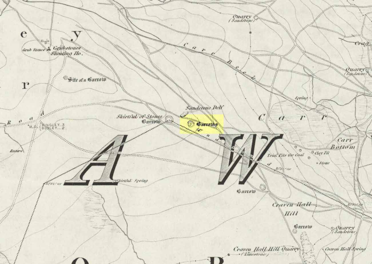
Follow the directions to reach the Great Skirtful of Stones giant cairn (very worryingly being encroached upon, illegally [it’s a protected monument], by employees of Bradford Council digging tracks into its edges). Walk less than 100 yards to the east, down the slight moorland slope (Leeds & Otley Chevin are in the distance). You’re here!
Archaeology & History
This is a very intriguing site. Intriguing because we don’t actually know what it is! It’s best seen at the end of winter, shortly after the heather-burning’s been done; but if there’s been no burning here, after a year or two it’s almost impossible to find!
Great Skirtful Ring on 1851 mapColls’ 1846 plan
Despite it being only a short distance east of the Great Skirtful giant cairn, very little has been written about it (a surprise in itself!) – but this is down the failings of archaeological professionals in the area, who still neglect this incredible prehistoric arean. It was first described in Mr J.N.M. Colls’ (1846) survey of sites in the region, where he thought it to be a prehistoric camp. Several years later the Ordnance Survey lads visited here and deemed it to be prehistoric barrows, which doesn’t seem true. Nearly a hundred years later, the great northern antiquarian Eric Cowling (1946) who saw fit to describe it as an “enclosure” — so I’m copying his idea so I don’t get into too much trouble! Thinking it to be a Bronze Age monument, he wrote:
“On the main ridge of Rombald’s Moor and about eighty yards to the east of the Great Skirtful barrow, is a small circular enclosure with a diameter of twenty yards. There appears to have been an entrance on the eastern side, which is protected by a short length of banking to the east.”
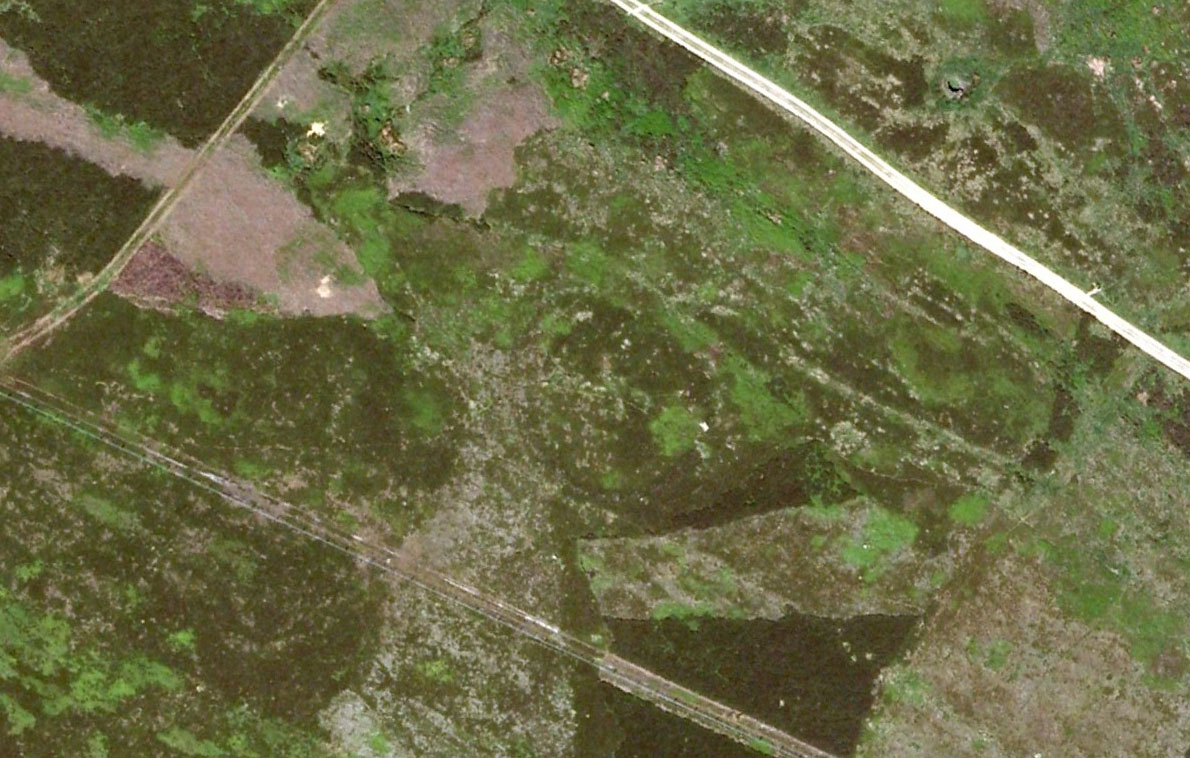
Aerial image, 2002Aerial image, 2009
The “length of banking” he described didn’t seem apparent when we visited the site yesterday (23.3.09), but we intend a further exploration of this and the adjacent monuments in the coming weeks and hope to locate it!
Interestingly, the archaeologists Faull & Moorhouse (1981:1:103), in their otherwise fine survey, actually doubted this place as having any prehistoric status, without giving any reason why—which was a big mistake. No doubt they spent too much time in offices and board meetings instead of getting out a bit more! Unless evidence to the contrary can be strongly presented, this site must be classed as undoubtedly prehistoric in nature (Bronze Age or Iron Age certainly) and almost certainly had something to do with rituals of the dead.
Great Skirtful Ring embankmentSouthern edge of the ring
From outer edge to outer edge the ‘ring’ measures 102 feet across, N-S, and with a rough maximum 101 feet E-W, being diameter, being some 300 feet in circumference. When you look at the site at ground level it appears to be an almost perfect ring, consisting of an embankment little more than 2 feet high at the most, with entrances both east and west. However, as the aerial images show, the perfect circle aint quite so perfect! But at ground level, there’s a certain uniformity about it. The embankment is in very good condition around much of the ring, with only slight damage in certain parts. The western opening strongly implies a direct relationship with the Great Skirtful cairn — which would infer this monument to have more of a ritual nature rather than the simple domestic enclosure, inferred by Colls and Cowling. Adding to this we find a tumulus 100 yards east and the remains of several other cairns nearby, making the site almost hemmed in by death-sites. A prehistoric cemetery is a short distance further down the moorland slopes to the east. Add also the fact that the Burley Moor stone avenue runs immediately south and the death-motif has to be increased.
What do I think it is? Not sure! The thought that it’s a previously unrecognized henge has crossed my mind…but henge monuments aren’t things that I’m very clued-up on, so wouldn’t like to say for sure. If there are any university archaeology students out there who are into getting their feet dirty, give this site a look-over. It’s intriguing, in very good condition, and could do with an accurate ID!
References:
Bennett, Paul, The Old Stones of Elmet, Capall Bann: Chieveley 2001.
Colls, J.N.M., ‘Letter upon some Early Remains Discovered in Yorkshire,’ in Archaeologia, volume 31, 1846.
Cowling, Eric T., Rombald’s Way, William Walker: Otley 1946.
Faull, M.L. & Moorhouse, S.A. (eds), West Yorkshire: An Archaeological Survey – volume 1, WYMCC: Wakefield 1981.
Using the OS-map as a guide, from Denton village head up the road northwest, past Moorside Farm and onto the moor. Before you reach the rise of Lippersley Pike you’ll reach the Crow Well itself (completely covered over by Yorkshire Water’s handiwork, stopping anyone from drinking the previously fresh waters here). In the middle of nowhere, just above the completely ruined well, is the old shooter’s cottage and from here, Eric Cowling (1946) told us to look in the heather immediately east. When Richard Stroud and I ventured here a few years back (2.8.5) we couldn’t find a thing — though a vaguely reminiscent structure seemed possible 300 yards away.
Archaeology & History
If the heather’s deep, you’ll have little chance of seeing the site as Eric Cowling (1946) obviously did! He described and illustrated this place — so was fortunate enough to have ventured here following the heather-burning.
The site is not a stone circle, but what Cowling thought to be an Iron Age settlement: ellipsoid in shape and nearly 400 feet across; it’s obviously an impressive archaeological site when visible (akin to the Snowden Carr settlement a couple of miles east). In all probability the site is much earlier than Iron Age.
An aerial image of the site indicates its size to be very close to Cowling’s initial measurements. The ‘settlement’ is quite huge, with the walling or defining edges being between 4 and 6 yards across in places, with double-walled sections akin to that found at the Brackenhall circle on Shipley Glen, just over 8 miles (13km) to the south. However, it’s probably much older than its Brackenhall compatriot. Its maximum diameters measure 130.5 yards (119.3m) roughly east-west and 98.5 yards (90m) roughly north-south, with an external circumference of about 345 yards (315m). This is a big fella! Near its centre is a well-defined ring, or ellipse, measuring approximately 20 yards (18.3m) north-south and 18 yards (17.5m) east-west.
It’s difficult to say what this might be without a site analysis, and we need the heather burning back at this site to enable a good inspection of the place! We may be looking at Denton Moor’s equivalent of the Woofa Bank Enclosure just over 4 miles (6.5km) to the south, above Ilkley, with its host of cup-and-rings and surrounding cairns. A good inspection of this site is long long overdue…
Hereabouts Cowling also found other remains dating from the neolithic period, including walling, cairns, hut circles and cup-and-ring stones. He thought that “the name Crow-well appears to be the modern equivalent of ‘the circle of the well'” — and although I doubted this in my Old Stones of Elmet, I have since come to realise the truth of his words!
To get here, ask all and sundry where Shipley Glen is and, once there, head to the Brackenhall Countryside Centre. It’s less than 100 yards past it, right on the roadside (a coupla nice birches sit in its edge).
Archaeology & History
Lay-out of Catstone’s Ring
Described by many local writers over the years and marked on modern OS-maps as ‘The Soldier’s Trench,’ this curious double-ring of stones has long been somewhat of an archaeological anomaly. The archaeologist John Barnatt thought it to be “almost certainly an enclosure, of indeterminate age”; and similarly so by Faull and Moorhouse (1981), who described it as a settlement or enclosure. It has previously been classified as a ‘stone circle’ by archaeologists, and although I’ve added it to the listing of such sites here on TNA, I do so as a historical tradition, as the site aint a true megalithic ring. Although we don’t know exactly what it was used for, we’re better using the term ‘enclosure’ for it.
The first description of the place was by J.N.M. Colls (1846). When the pseudonymous Johnnie Gray (a.k.a. Harry Speight) got here he wrote:
“It comprises portion of an earthwork (which was perfect a few years ago), raised between two concentric circles, whose grater circumference is 137 yards, and diameter 57 yards north to south, and 39 yards east to west… There are unmistakable evidences about it of immense fires.”
Earliest known image (Glossop 1882)
At least two of the stones in this double-ringed complex have cup-markings etched on them; though Boughey and Vickerman (2003) report a third such carving, but doubt its authenticity. They may be right.
Folklore
The other name for this site, the Soldier’s Trench, comes from an old tale which relates to the place being used as a camp by a group of soldier’s the night before they went into battle.
Drawing by John la Page (1951)
The site stands right next to a prominent geological fault (as any visitor clearly sees!). It’s likely that this cleft in the Earth is one of the causative factors in the creation of numerous UFO phenomena that have been reported hereabouts through the years. One large spherical object with a very slight ‘tail’ to the rear, travelled slowly over this site in the 1980s and was watched for several minutes slowly following the geological ridge up and round Baildon Hill to the north, fading back to Earth and eventually out of sight.
References:
Baildon, W. Paley, Baildon and the Baildons – parts 1-15, Adelphi Press: London 1913-1926.
Bennett, Paul, The Old Stones of Elmet, Capall Bann: Milverton 2001.
Boughey, Keith & Vickerman, E.A., Prehistoric Rock Art of the West Riding, WYAS 2003.
Colls, J.N.M., ‘Letter upon some Early Remains Discovered in Yorkshire,’ in Archaeologia 31, 1846.
Faull, M.L. & Moorhouse, S.A. (eds.), West Yorkshire: An Archaeological Survey to AD 1500 – 4 volumes, WYMCC: Wakefield 1981.
Glossop, William, ‘Ancient British Remains on Baildon Moor,’ in Bradford Antiquary, 1882.
Gray, Johnnie, Through Airedale from Goole to Malham, Elliott Stock: London 1891.
Hedges, John (ed.), The Carved Rocks on Rombald’s Moor, WYMCC: Wakefield 1986.
la Page, John, The Story of Baildon, Byles: Bradford 1951.


")


")


