Spittal of Glenshee, Kirkmichael, Perthshire

Standing Stone:  OS Grid Reference – NO 10865 70201

Also Known as:

  1. Canmore ID 29609

Getting Here

Spittal of Glenshee stone

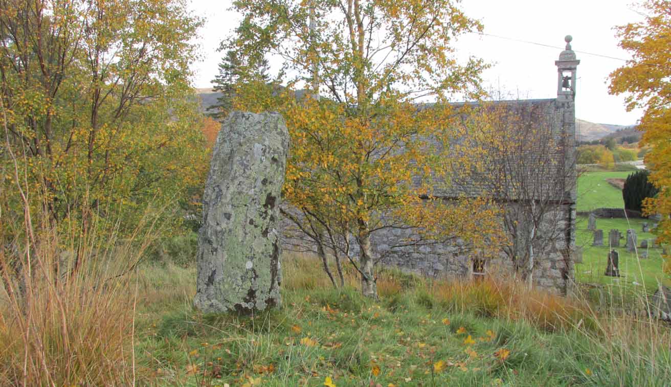
Take to A93 road, north, between Blairgowrie and Braemar, keeping your eyes peeled many miles on, to turn left along the minor road as you approach the tiny Spittal of Glenshee hamlet. Just as you go over the ancient bridge, park up on your left, below the church.  Walk round the back of the church and you’ll see a large tree-covered mound.  Walk onto its top.

Archaeology & History

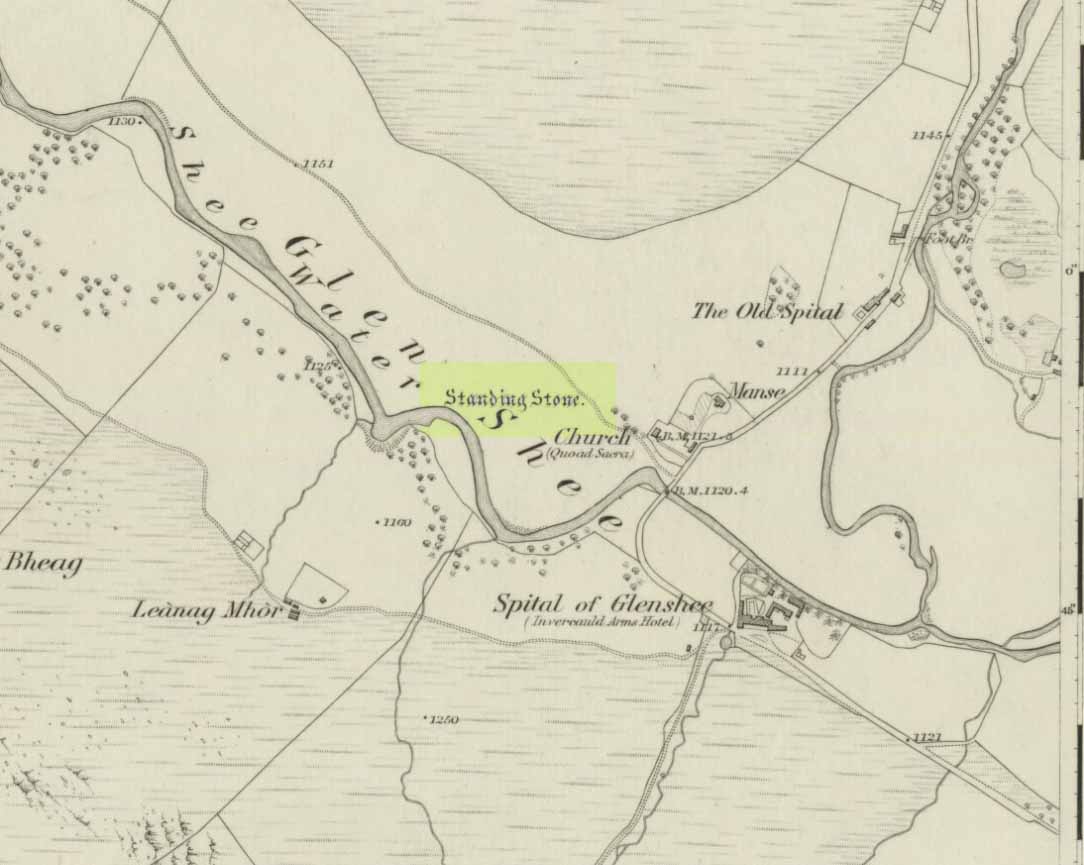
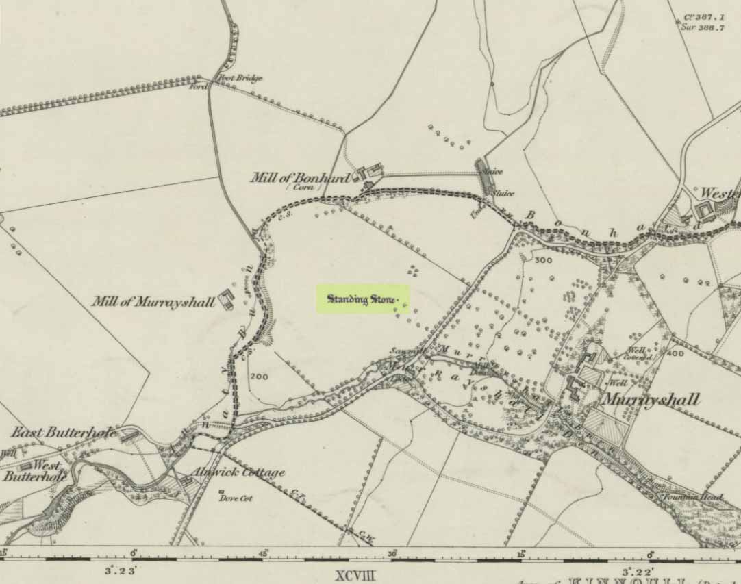
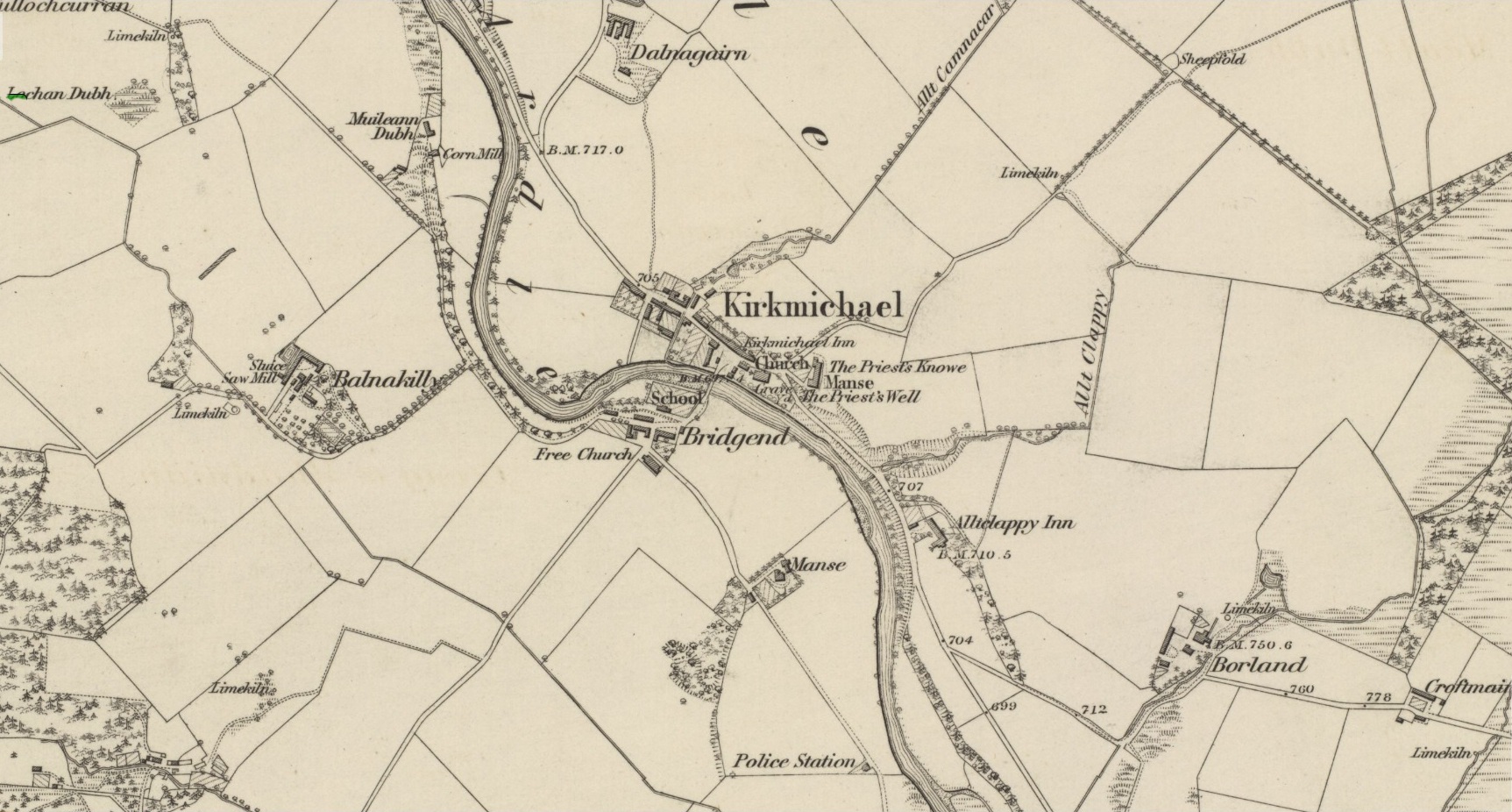
Stone marked on 1862 map

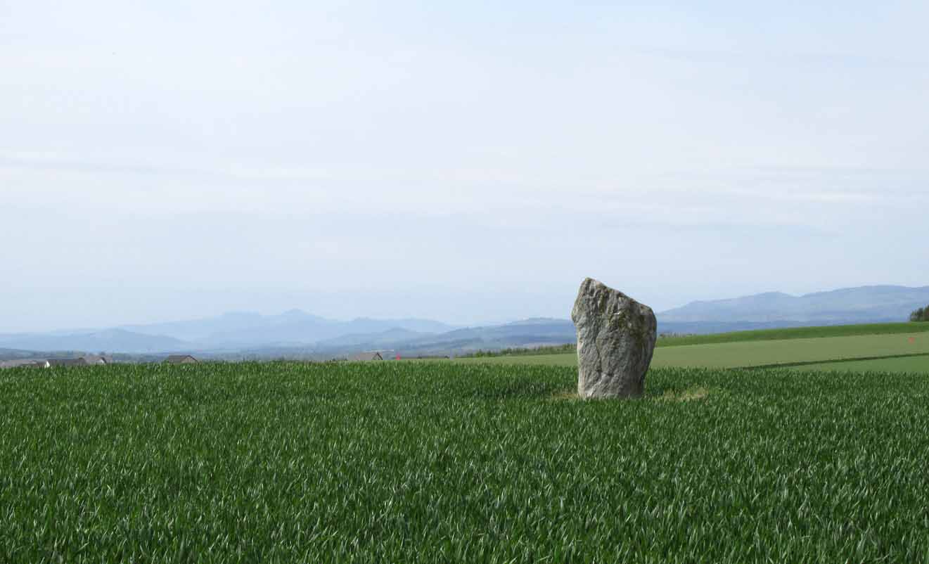
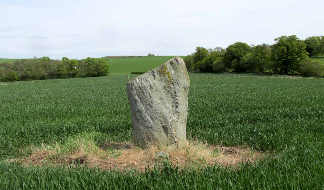
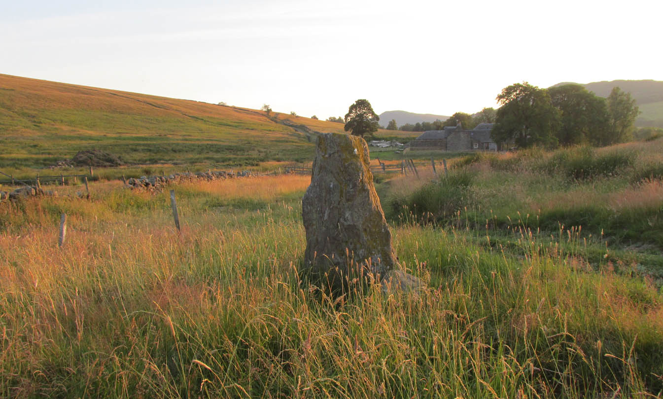
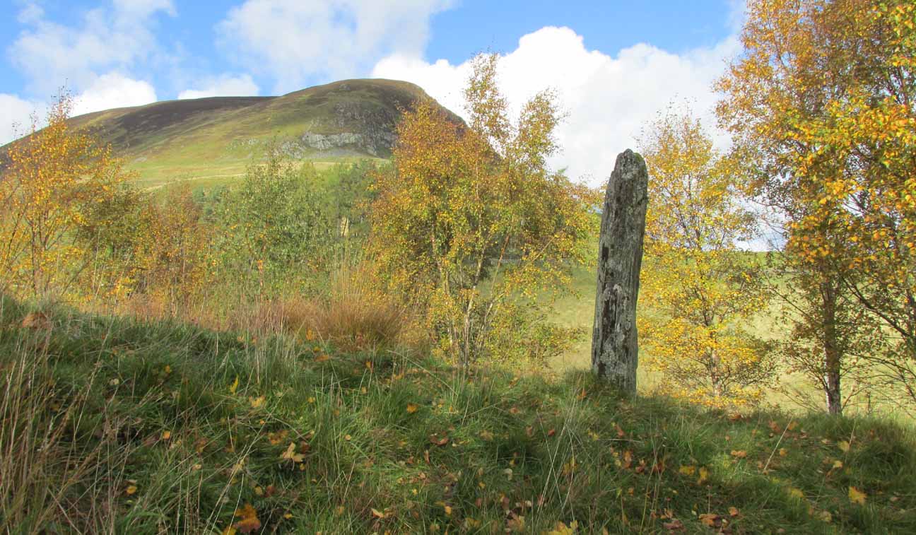
This quiet, almost hidden, six-foot tall standing stone on what initially seems to be a large fairy mound or tumulus at the back of the rude church, has been occluded from general view (in my opinion, deliberately) by the construction of the more debased christian edifice right in front of it.  But it detracts not from its gentle majesty once you reach its ancient body, atop of the old hill.

The stone is one in a cluster of prehistoric sites in and around this Glen of the Fairy Folk (as its name tells), where the rivers Shee and Beag converge.  If the church didn’t obstruct the view, some of the other sites would have been visible from here.

Folklore

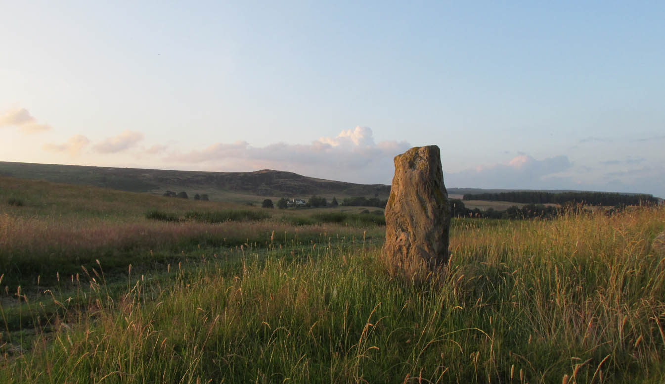
The old stone, looking east

Folklore tells that when the christians came into the Glen to build a church—initially a half-mile or so to the east—the little people were much annoyed at the actions of the incomers, as it intruded on one of their sacred rings of stone close by.  By night they came out, and every stone that had been laid by the christians in the day was removed.  Each day the insensitive christians came and built their church without asking, and each night the little people removed it.  Eventually an agreement was made, and the fairies let them build the church next to this standing stone.  So goes the tale….

A veritable cluster of stories about Fingal, Ossian, Dermid and Grianne scatter this area, with many of them relating to ancient sites, but I’ve not found one directly relating to this stone.

References:

  1. Miller, T.D., Tales of a Highland Parish, Munro Press: Perth 1929.

© Paul BennettThe Northern Antiquarian


Murrayshall, Scone, Perthshire

Standing Stone:  OS Grid Reference – NO 15200 26263

Also Known as:

  1. Balgarvie (Swarbrick)
  2. Canmore ID 28135
  3. Mill of Bonhard

Getting Here

Murrayshall standing stone

On the main road (A94) through Scone, go east along either Murrayshall Road or Bonhard Road for a short distance until you go out of the town and into the countryside. About ⅓-mile (0.5km) along the country lane, go left at the road junction; and just another ¼-mile on, notice the field-gate on your left.  As you’ll see, the standing stone is just over 100 yards away in that field.

Archaeology & History

Murrayshall on 1867 map

In a region littered with megaliths, this fine upright single stone stands, quite deliberately, at a point in the field where you have excellent 360° views, which to the north looks way into the orgasm of the Scottish mountains.  History and tradition seem to tell it has always been a loner, without companions, but no archaeological excavation has taken place here to my knowledge; and the apparent proximity of some type of prehistoric ring-ditch 30 yards away may be related to the stone.  But we don’t for sure…

Close-up of cupmark

North-face with cupmark

Despite being shown on the first OS-map of the region in 1867 and despite being a large monolith more than 6 feet tall, very little seems to have been said of it.  It was included in Swarbrick’s (2012) poorly arranged survey; and the Royal Commission (1994) merely listed it, without comment, other than to say “it bears no markings.”  Yet when Paul Hornby and I visited the place recently, a large single cup-mark is plain to see on the north-face of the stone.

Although the stone is alone in this field, once you start exploring the hills a short distance to the south and the farmed fields heading north and east, masses of prehistoric sites begin to appear.  It’s well worth checking out!

References:

  1. Royal Commission on the Ancient & Historical Monuments of Scotland, South-East Perth: An Archaeological Landscape, HMSO: Edinburgh 1994.
  2. Swarbrick, Olaf, A Gazetteer of Prehistoric Standing Stones in Great Britain, BAR: Oxford 2012.

Acknowledgements:  Huge thanks as always to Paul Hornby for getting us to this site.  Plus, accreditation of early OS-map usage is reproduced with the permission of the National Library of Scotland.

© Paul BennettThe Northern Antiquarian


Meikle Findowie, Little Dunkeld, Perthshire

Standing Stone:  OS Grid Reference – NN 96105 39143

Also Known as:

  1. Canmore ID 86434

Getting Here

Meikle Findowie stone

Along the A822 road between Dunkeld and Milton, 4.7 miles (7.6km) west of the A9, turn left down the track signposted ‘Meikle Findowie’.  About 700 yards along the track you’ll reach a modernised farmhouse and here, on your left, a track takes you eastwards (left).  Go along here for about 100 yards until, just before the modernised house on your right (it was just a pile of ruins when we came here), you’ll see the standing stone in front of it.

Archaeology & History

Looking westwards

Beside the old trackway that runs east-west past Meikle Findowie, above the ancient flood-plain of the breathing River Braan, a solitary stone lives by the more modern shadow of old sheep-folds.  Tis a quiet little fella, less than 5 feet tall, that you could almost pass as a forgotten gatepost if you chattered when walking by. But it’s much more ancient than any old gate…

It nestles below the old hill of Airlich, with its beautiful stone circle and huge ancient enclosures higher up: a chunky old stone with no carvings or other human marks upon it.   Tis a site site worth visiting before heading uphill, to the megalithic ring of enchantment.

Acknowledgements:  Huge thanks as always to Paul Hornby for getting us to this site.

© Paul BennettThe Northern Antiquarian


Netherfoodie Cottage, Dairsie, Fife

Standing Stones (destroyed):  OS Grid Reference — NO 4128 1769

Also Known as:

  1. Dairsie Stones

Archaeology & History 


View of the field where the stones stood (Paul Hornby)

Recent archaeological investigations at the site which has become known as the Dairsie Hoard—where many pieces of broken Roman silverware were seemingly deposited in one spot, adjacent to a dried bog “which may arise from a former spring” of water—brought about the discovery of much earlier megalithic remains.  The position of two previously unrecorded standing stones were found during the archaeological dig here.  In the most recent edition of Current Archaeology, Fraser Hunter (2018) described the position of the Roman silverware close to some ancient pits or sockets in the ground. This “group of features was…intriguing”, he told,

“for two of them contained stumps of standing stones, one in association with probably Bronze Age pottery. This hoard had been buried in a memorable, perhaps even a sacred site, between an intriguing wet spot on one side and, on the other, two standing stones, which were already ancient by the time the silver was buried.  Such burial of valuables in association with prehistoric monuments can be readily paralleled elsewhere.  It suggests this silver was placed under the care of the gods, probably as a sacrifice rather than a burial for safekeeping.”

Two thousand years before the Roman silver deposit had been deposited, megaliths here stood.  Sadly they’re long gone, leaving more questions than answers as usual…

References:

  1. Hunter, Fraser, “Solving a Silver Jigsaw,” in Current Archaeology, 335, February 2018.

Acknowledgments:  Many thanks to Paul Hornby for use of his photo in this site profile.

© Paul Bennett, The Northern Antiquarian


Tom-a-Clachan, Kirkmichael, Perthshire

Stone Circle (destroyed):  OS Grid Reference – NO 08129 60093

Archaeology & History

Kirkmichael village, 1867

Kirkmichael parish was an area that was described by George Chalmers (1887) as possessing “a vast body of Druid remains,” there being “a number of Druid cairns in the vicinity of Druidical circles.”  As we know, the term ‘druid’ has long fallen out of favour; and with it in this area, the sites themselves have taken a similar fate.

Found on the east side of the village, on raised ground known as the Priest’s Knowe up above the Priest’s Well, this stone circle is not listed in any of the archaeological textbooks, but its existence was thankfully recorded in one of the essays by regional historian Charles Fergusson.  He told us that,

“one of these Druidical circles stood at Tom-a-Chlachan — the Hillock of Stones — where the Manse of Kirkmichael now stands, and there two thousand years ago our rude ancestors worshipped, according to their faith, in their circle of stones; and there, as elsewhere, when the pioneers of Christianity came to the district, they found it expedient to place their new church where the old circle of stones had stood, so the first church of St Michael was reared where the old clachan stood, on what the natives already considered holy ground.”

The Priest’s Well can still be seen by the roadside.

References:

  1. Chalmers, George, Caledonia – volume 1, Alexander Gardner: Glasgow 1887.
  2. Fergusson, Charles, “Sketches of the Early History, Legends and Traditions of Strathardle and its Glens – part 5,” in Transactions of Gaelic Society Inverness, volume 21, 1899.

Acknowledgements:  Many thanks to ‘Geoffrey of Kirkmichael’ for help with amending the location of the site.  Thanks Geoff.  And big thanks for use of the 1st Edition OS-maps, reproduced with the kind permission of the National Library of Scotland.

© Paul BennettThe Northern Antiquarian


Fuke Well, Pudsey, West Yorkshire

Healing Well (destroyed):  OS Grid Reference – SE 22 33

Archaeology & History

Ths curiously-named site is described just once in very early field-name records as the ‘Fukewell’.  Included in A.H. Smith’s (1961) magnum opus, he passes over the place-name without comment.  But in finding his 12th century literary source, we read that it was located on some land given to the monks of Kirkstall Abbey, Leeds.  Written in early disjointed Latin, we find that the Fukewell was mentioned on a grant that described five acres of land given by one Adam Samson to the monks of the Abbey.  On one of the acres was a site known as the Cold Well, whilst the Fuke Well was found on a piece of land adjacent to a house, but its precise location seems to have been lost.  Nothing is mentioned about it by great Pudsey historan Simeon Raynor, despite him naming a number of other wells in the area – so we must presume that the site had already gone when he came to write his work.

But what does the word fuke actually mean?  There is nothing to explain it in Wright’s Dialect Dictionary, nor other regional dialect or place-name works.  I was wondering if it derived from the old english word ‘fuck’, which was common parlance in earlier centuries.  ‘Fucking’ was a word that didn’t have the debased christian ideology attached to it: of something not to be talked about, or be hidden.  To have a fuck, or go fucking, was always quite normal; and to most people in the real world we use the same term with absolute ease – because we all do it!  But this etymological idea is pure speculation on my part.  Can anyone give clear light to fuke’s real meaning?

References:

  1. Fryer, Peter, Mrs Grundy, Dennis Dobson: London 1963.
  2. Lancaster, W.T. & Baildon, W. Paley (eds.), The Coucher Book of the Cistercian Abbey of Kirkstall, Thoresby Society: Leeds 1904.
  3. Smith, A.H., The Place-Names of the West Riding of Yorkshire – volume 3, Cambridge University Press 1961.

© Paul BennettThe Northern Antiquarian 


Kalemouth Carving, Eckford, Roxburghshire

Cup-and-Ring Stone:  OS Grid Reference – NT 714 275

Archaeology & History

Kalemouth carving (after R.W.B. Morris 1981)

Now housed in the National Museum of Antiquities in Edinburgh, this little-known petroglyph was rediscovered in 1957 by a Mr G.F. Ritchie, not far from the once-large Kalemouth neolithic tomb.  It’s a carving that seems to be quite isolated (no others are known about in the immediate area), comprising of an incomplete four-ringed design which, in all probability, is a stray rock that came out of a nearby prehistoric cairn—although we don’t know this for sure.

The carving was described in Ron Morris’ (1981) petroglyph survey, where he told us that,

“In the field “not far from the cairn” (just E of the farm), was a small convex gritstone boulder 25cm by 15cm by 15cm (¾ft  x ½ft x ½ft). On its fairly smooth surface is:

a cup-and-four-rings with 2 parallel grooves from the inner ring (which is incomplete) through the others (which are gapped)—the outer two being now incomplete also—a form of ‘keyhole pattern’.”

A near-identical carving on a similiar-shaped portable stone can be seen in Galashiels museum, whose history has seemingly been forgotten.

References:

  1. Morris, Ronald W.B., “The cup-and-ring marks and similar sculptures of Scotland: a survey of the southern Counties – part 2,” in Proceedings of the Society of Antiquaries, Scotland, volume 100, 1967.
  2. Morris, Ronald W.B., “The Cup-and-Ring and Similar Early Sculptures of Scotland; Part 2 – The Rest of Scotland except Kintyre,” in Transactions of the Ancient Monuments Society, volume 16, 1969.
  3. Morris, Ronald W.B., The Prehistoric Rock Art of Southern Scotland, BAR: Oxford 1981.

© Paul BennettThe Northern Antiquarian


Heygate Stone, Baildon, West Yorkshire

Cup-and-Ring Stone:  OS Grid Reference – SE 15942 40187

Archaeology & History

Heygate Stone

This excellent cup-and-ring marked petroglyph was found fortuitously in September 2001 by the land-owner at Near Hey Gate field to the northeast of Baildon village.  He was clearing out remains of some old walling in the field and, adjacent, a rock that was protruding out of the ground got turned over.  Underneath it he noticed a series of very well-preserved cups and rings in a cluster near one part of the rock.  It was a bittova beauty to be honest!

Thankfully due to the subsequent efforts of local rock art students Mike Short and Keith Boughey, it was later re-housed in the Brackenhall Centre at the edge of Shipley Glen.

Enhanced rendition of Boughey’s Heygate Stone rubbing
Computer-enhanced image of the carving

The stone itself was once larger than it now is and may have had additional carved elements on it, but the other portion that had broken off wasn’t located when it was first dug out of the ground.  This may mean that it was moved here from another location, which would have been somewhere close by.  Many other petroglyphs exist in and around the Baildon district.As we can see in the images here, two very well-defined double cup-and rings have clusters of smaller singular cup-and-rings around their edges.  A single cup-mark was etched below the largest of the double-ring carving, and what seems like a carved straight line emerges from the largest of the single cup-and-ring.

References:

  1. Griffiths, Kathie, “Historic Stone Back Home on Moors,” in Telegraph & Argus, 11 November, 2006.
  2. Short, Mike, “The Heygate Stone,” on Megalithic Portal, 21 November, 2006.

Acknowledgements:  Big thanks to Mike Short for his info and to Keith Boughey whose rubbing I’ve touched-up and used in the site profile.

© Paul BennettThe Northern Antiquarian


Holy Well, Baildon, West Yorkshire

Holy Well (destroyed):  OS Grid Reference – SE 1609 3961

Archaeology & History

This site is all but unknown to the great majority of folk in Baildon, and even some of the local historians have let it slip from their investigative tendrils.  According to the primary Baildon historian, W.Paley Baildon, it was first known as the ‘Halliwell Holy Well’.  In his magnum opus (1913-26) of the township he relates that,

“The 1852 Ordnance map marks Halliway Banks Wood to the south of Langley Lane, with a well just below it, and a footpath from Holden Lane to the well.  Halliway, I think, is a corruption of Halliwell, the ‘holy well,’ with the special footpath leading to it and nowhere else.  Haliwell Bank occurs in (the Baildon Court Rolls of) 1490, when it formed part of the property held by William Tong of Nicolas Fitz William.”

This etymology is echoed by the great place-name authority A.H. Smith (1954).  It also caught the attention of archaeologist Andrea Smith (1982), in her investigation of twenty-five holy wells in the West Yorkshire region.

“Many wells,” she wrote, “are recorded simply as ‘Holy Well,’ or the various forms ‘Halliwell,’ ‘Helliwell’ and ‘Hollowell.’  It is possible that in these instances the identity of the patron saint or guardian of the well has been forgotten, which may be the case with the site at Collingham, now known as Hollowell.”

Site of the Holy Well in 1852

The well itself can no longer be seen.  When I looked for the site in 1982, I found that to the right of where the 1852 map showed it, was a waterworks lid covering the old holy waters, just in the trees atop of the field beneath a great sycamore with a number of small stones roughly encircling the site: perhaps the only possible relics of the century before when the waters would have been used.  A stone trough was situated at the bottom of Holden Lane, fed by the waters from the Halliwell and from here the course of the stream meandered down the side of Slaughter Lane, now known as Kirklands Road.  The land around Halliwell became known as Kirkfield, or field of worship.

A local resident told how during autumn and winter, the left side of the field gets extremely boggy – the region were the old stream ran from the old well, along which dowsers have found aquastats abound.  Now however, houses have been built where the waterworks-lid used to be and is likely to be in someone’s backyard, all but forgotten.

Folklore

According to local lore, the site of this most ancient of holy wells was found in the warmest place in the Baildon district.  Whilst its geographical position doesn’t necessarily suggest this (although it did face south, into the sun), this lore may reflect some healing aspect of the well that has long since been forgotten.

Perhaps relevant to Andrea Smith’s comment about there being ‘guardians’ at holy wells is found in folklore relating to nearby Holden Lane: locals in the last century also referred to it as Boggart Lane, so called after the Boggart which was seen there in the form of a spectral hound that was said to possess large glowing red eyes and was a sign of ill omen.  Modern sightings of the spectral hound, which appeared along the road which led to the old well, are unknown.

References:

  1. Baildon, W. Paley, Baildon and the Baildons (parts 1-15), St. Catherines: Adelphi 1913-26.
  2. Smith, A.H., English Place-Name Elements – volume 1, Cambridge University Press 1954.
  3. Smith, Andrea, ‘Holy Wells Around Leeds, Bradford & Pontefract,’ in Wakefield Historical Journal 9, 1982.

© Paul BennettThe Northern Antiquarian


Lower Headley Farm, Thornton, Bradford, West Yorkshire

Tumulus (destroyed):  OS Grid Reference – SE 099 321

Archaeology & History

Headley Farm urn

There are no longer any remains of the prehistoric burial site that once stood in one of the fields by Lower Headley Farm.  We don’t know whether the site was a cairn, a tumulus, or just a stone-lined cist; but in all probability it would have been a low rounded hillock whose existence had long since fallen out of oral tradition.  All that we do know is that in one of the fields by the farm, some very well preserved urns—either neolithic or Bronze Age by the look of it—were unearthed, indicating a site of prehistoric provenance.

The finds were described only briefly in the first edition of the Bradford Antiquary (1888) journal, where it was reported:

“During the spring of 1880 an interesting discovery was made by Mr. Abraham Craven, quarryman, of Thornton.  The ‘find’ comprised three funeral urns, which Mr. Craven turned up while baring a portion of a field in Lower Headley Farm, the property of the trustees of Sowerby Grammar School.  The discovery was made within a short distance of the surface, the pottery presenting undoubted indications of pre-Roman origin.  From evidence collected upon the spot, and the appearance of the pottery, two of the urns were about 14in in height, 9in across the top, 11½in at the widest portion of the bowl, and 6in at the foot.  One of the urns was of sun-burnt clay, with rude markings, the other having evidently been subjected to fire.  No coins, personal ornaments, or other indications of civilisation, were found in the urns, but each one contained human dust and bones.  From the fact that several other urns have been met with in the immediate vicinity, equally rude in type, evidence is not wanting that the picturesque mound upon which Headley is situate was inhabited at a very early period of British history.”

References:

  1. Anonymous, “Valuable ‘Find’ at Headley, near Thornton,” in Bradford Antiquary, volume 1, 1888.

© Paul BennettThe Northern Antiquarian