Barmishaw Stone, Ilkley Moor, West Yorkshire

Cup-and-Ring Stone:  OS Grid Reference – SE 11193 46417

Also Known as:

  1. Barnishaw Stone
  2. Carving I/4 (Davies)
  3. Carving no.92 (Hedges)
  4. Carving no.253 (Boughey & Vickerman)

Getting Here

The Barmishaw Stone

Follow the same directions to reach the superb Badger Stone carving, and from here take the footpath that runs downhill.  You’ll cross another footpath about 100 yards down the moor, but just keep walking down the path and you’ll notice the small copse of woods ahead of you.  As the footpath begins to swerve roughly away, northeast, heading away from the said woodland, keep your eyes peeled on your left for a reasonably large but flattish rock close to the ground (in summer it’s surrounded by bracken) about 75 yards away.  That’s your target!

Archaeology & History

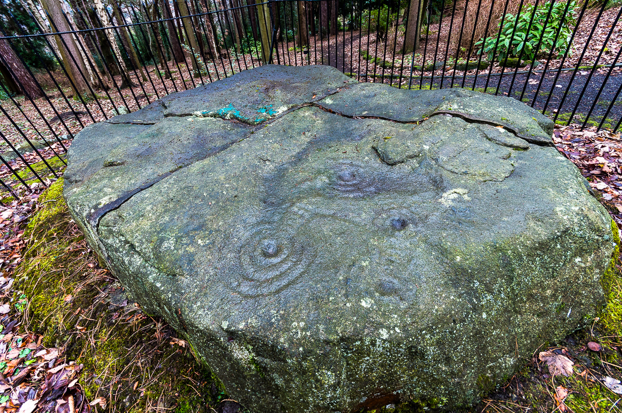
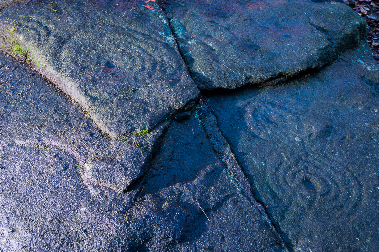
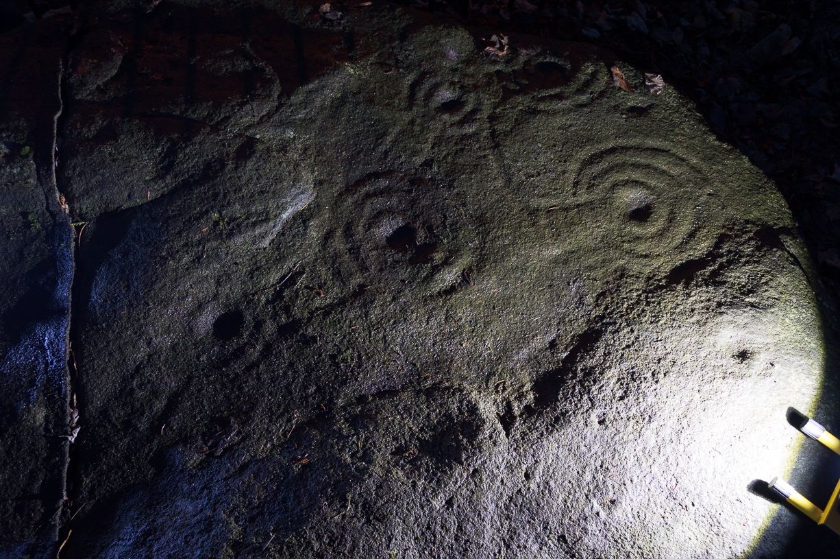
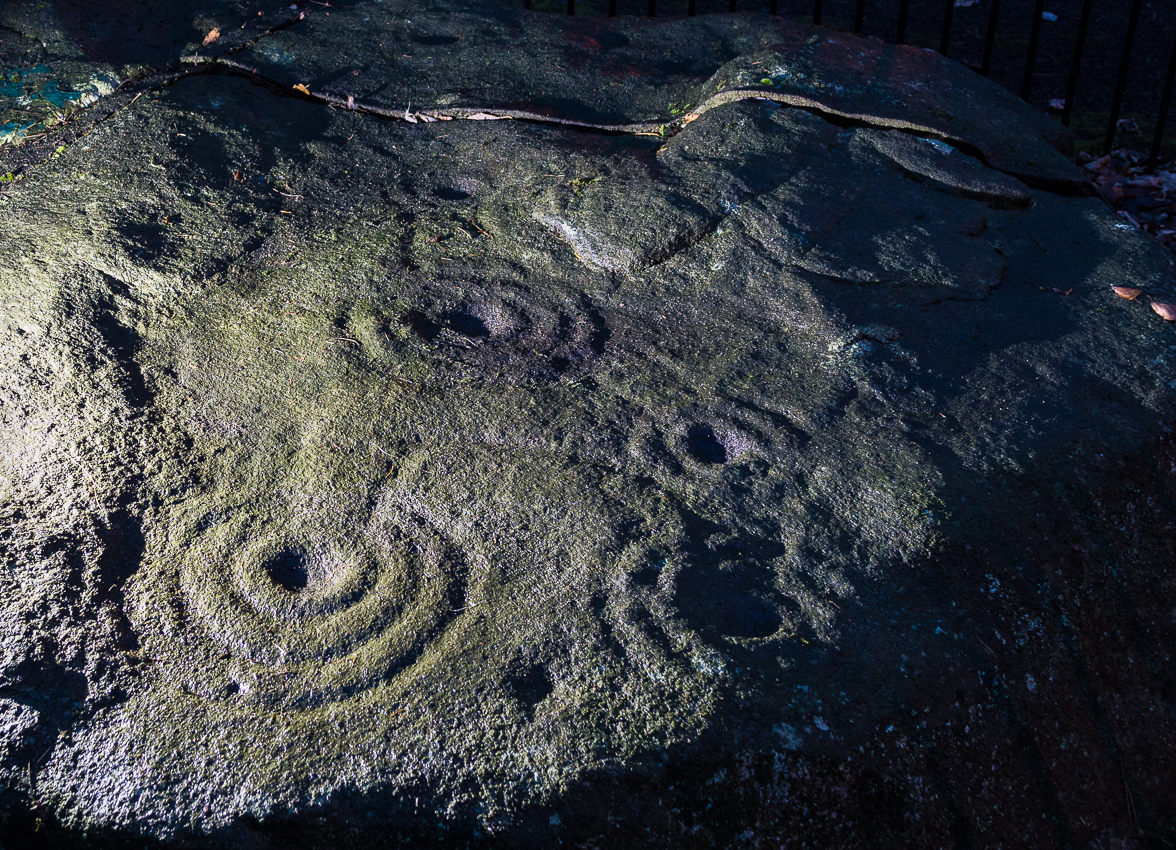
Of the hundreds of cup-and-ring stones on Ilkley Moor and district, this is one of my personal favourites!  I first visited the stone in 1977 as a young teenager and was mightily impressed by the unusual nature of the design here — and that impression still remains.  Aswell as possessing the usual cups and rings, the Barmishaw Stone is one of just a few rocks also possessing a sort of ‘ladder’ design or linear pattern within the overall carving: an insignia echoed on the nearby Willie Hall Wood carving, the Piper Stone, and also on the Panorama Stones.  As with the ‘ladders’ on the Panorama carving, those found here at Barmishaw are very eroded and are increasingly difficult to see during the daytime (the best time to notice them is usually around sunrise or sunset, and particularly when the rock itself is wet).

The carving has been described many times, albeit briefly, by a number of writers.  In John Hedges (1986) fine survey he said the following:

Barmishaw Stone, looking northwest
Barmishaw Stone, looking southeast

“Medium sized flat-topped rock…fairly smooth grit, sloping slightly east to west, covered with carvings, some of which are very worn.  Slanting sunshine needed to detect them.  About twenty-four cups, at least nine with rings or incomplete rings, two with multiple grooves half round and continuing straight down, one of them incorporating ‘ladder.’  Five other ‘ladders’ – in a good light.  Cups mostly deep and clear.”  A few years later, Boughey & Vickerman (2003) echoed much of Mr Hedges description, though noted that of the 24 cups with their rings, one possessed a triple ring.

Alan Davies’ illustration

Like so many cup-and-ring stones, they have given rise to hosts of fascinating theories and ideas — one of which is based on mathematics and metrology.  In the 1980s, Alan Davies (1983, 1988) surveyed the Barmishaw Stone — and other carvings on Ilkley Moor — to explore the possibility that the cups and rings were laid out according to a basic unit of measure, the Megalithic Inch (MI), as proposed by Alexander Thom some years earlier.  Although Davies’ work showed that such a primary unit of measure wasn’t to be found universally, his research at the Barmishaw Stone indicated “significant evidence for quanta of…3 MI,” although this occurred “when the analysis is restricted to only ringed cups.”  Despite this, Davies thought that the existence of the Megalithic Inch was evident in this and other carvings on the moors, stating that:

“The repeated emergence of the significance of ringed cups, and the fact that all putative quanta seem to bear a simple numeric relation to each other do not seem to be coincidental.”

However, the selectivity of data in Davies’ research would indicate more that any Megalithic Inches isolated in the metrology of the carvings was due, not simply to chance, but more that the implements used to carve the rocks and the size of the hands of the people doing the carvings was pretty uniform.  These simplistic factors need assessing.  In modern trials carving cup-markings, we find them to be of similar size to those carved in prehistoric times, as would be expected.

Barmishaw Stone (after Hedges, 1986)
Barmishaw stone (Cowling 1946)

The ladder motif central to this carving may have related to early religious and ritual events here.  Across the world, indigenous cultures commonly relate the ‘ladder’ to be a symbol of ascension, both by shamans, mystics and during rites of passage.  The symbol represents the journey of the soul to and from supernatural realms.  To discount this possibility at the Barmishaw Stone would be shortsighted.

The carving was very probably painted when our neolithic ancestors gathered here, much as Australian aborigines still do to their carvings using lichens and other plant dyes, with the respective ladders and lines changing colour where movements between worlds or shifts of attendant spirit occurred.  By virtue of the its very name, I consider this rock to have been considerably important; the “ghost” aspect to barmishaw being a typically misconstrued aspect of ‘spirit’.

Folklore

This excellent cup-and-ring marked stone probably derives its name from the old dialect words “barm i’ t’ shaw”, meaning “ghost in the wood” stone.  Whatever guise the attendant spirit of this rock may have had has long since been forgotten; though spectral accounts from the beginning of the nineteenth century until modern times may give us clues.  There have been several reports of green-coloured elemental creatures around the area between here and the White Wells sacred spring a short distance to the east.  The most recent account, from 1987, took on the modern mythic form of a little green man from space, with attendant UFO to boot!  The Barmishaw Hole nearby was a place where faerie-folk used to live.  Excesses of geological faulting and water makes the magickal nature of this place particularly potent.

References:

  1. Allen, J. Romilly, “The Prehistoric Rock Sculptures of Ilkley,” in Journal of the British Archaeological Association, volume 35, 1879.
  2. Allen, J. Romilly, “Notice of Sculptured Rocks near Ilkley,” in Journal of the British Archaeological Association, volume 38, 1882.
  3. Bennett, Paul, “Cup-and-Ring Art”, in Towards 2012, volume 4, pp.83-92, 1998.
  4. Bennett, Paul, The Old Stones of Elmet, Capall Bann: Milverton 2001.
  5. Boughey, Keith & Vickerman, E.A., Prehistoric Rock Art of the West Riding, WYAS: Wakefield 2003.
  6. Cowling, E.T., ‘A Classification of West Yorkshire Cup and Ring Stones,’ in Yorkshire Archaeological Journal 1940.
  7. Cowling, E.T., Rombald’s Way: A Prehistory of Mid-Wharfedale, William Walker: Otley 1946.
  8. Davis, Alan, ‘The Metrology of Cup & Ring Carvings near Ilkley in Yorkshire,’ Science Journal 25, 1983.
  9. Davies, Alan, ‘The Metrology of Cup and Ring Carvings,’ in Ruggles, C., Records in Stone, Cambridge University Press 1988.
  10. Eliade, Mircea, Patterns in Comparative Religion, Sheed & Ward: London 1958.
  11. Hedges, John (ed.), The Carved Rocks on Rombalds Moor, WYMCC: Wakefield 1986.
  12. Wright, Joseph, The English Dialect Dictionary – volume 1, Henry Frowde: Oxford 1905.

© Paul Bennett, The Northern Antiquarian 


Snowden Carr (597), Askwith Moor, North Yorkshire

Cup-Marked Stone:  OS Grid Reference – SE 17965 51158

Getting Here

Find your way to the excellent Tree of Life cup-and-ring stone, then walk about 10-15 yards west.  It’s under your nose!

Archaeology & History

Single cup-marked stone

Another stone for the rock art purists amongst us: a singular cup-marking near the edge of the rock.  Although the photo here seems to show three cup-markings close to each other, only one of the three is in fact real.  The other two are simple geological creations.  But this fact seemed to go over the heads of some English Heritage archaeologists who reported to Boughey & Vickerman (2003) that this was a stone “with three cup markings” on it.  I’m not sure who trains EH rock-art enthusiasts, but they seem to have a tendency to mistake natural features with artificial cup-markings and their evaluations should be treated with considerable caution (you’ve gotta wonder who the students are that are teaching them).

The rock itself is found in close association with other prehistoric remains and may have been a part of enclosure walling.  Very close by are numerous well-preserved settlement remains, cairns and other cup-and-ring stones.

References:

  1. Boughey, Keith & Vickerman, E.A., Prehistoric Rock Art of the West Riding, WYAS: Wakefield 2003.

© Paul Bennett, The Northern Antiquarian


Burhill Kiln Allotment (415), Appletreewick, North Yorkshire

Cup-and-Ring Stone:  OS Grid Reference – SE 07792 61829

Also Known as:

  1. Carving no.415 (Boughey & Vickerman)
Burhill’s cup-and-ring stone (image courtesy ‘QDanT’)

Getting Here

Probably the easiest way is to park up at Stump Cross Caverns on the B6265 road, then walk down the road for 200 yards till you reach the track on your left running over the fields in the direction towards Simon’s Seat.  Walk along the track past the Skyreholme Wall carving, where it starts going downhill and, 100 yards before you reach the fork in the tracks, look in the field on your left.  The other route is to go east through Appletreewick village up to and through Skyreholme as far as you can drive, where the dirt-track begins.  Keep going up till you hit the fork in the tracks.  Go left, then thru the first gate you come to and walk up into the second field up where the notable rock stands out.  If you can’t see it at first, look around!

Archaeology & History

Boughey & Vickerman’s plan of the carving

This carving was rediscovered by Stuart Feather (1964) in one of his ambles in the area — and he would have been pretty pleased when he found this one!  It is the most complex and ornate of all the prehistoric carvings in and around this large open field.  With at least nine cup-and-rings and more than fifty other cups etched onto its rounded upper surface, there are various other lines and grooves linking up some elements of this mythic design. The best ones are on the upright and sloping east-face of the rock, into the rising sun.  In animistic terms the rock is distinctly female in nature.

Illustrated in one of Stan Beckensall’s (1999) works, the rock art students Boughey & Vickerman (2003) also include it in their survey, but give an inaccurate grid reference for the site.  They nevertheless describe it as:

“Large upstanding rock with slightly domed top surface. Most of top surface decorated but weathering makes detail uncertain: over sixty cups, eight or more with rings, many grooves.”

Many other carvings can be found in the area.

References:

  1. Beckensall, Stan, British Prehistoric Rock Art, Tempus: Stroud 1999.
  2. Boughey, Keith & Vickerman, E.A., Prehistoric Rock Art of the West Riding, WYAS: Wakefield 2003.
  3. Feather, Stuart, “Appletreewick, W.R.” in ‘The Yorkshire Archaeological Register, 1963’, Yorkshire Archaeological Journal, 41 (part 162), 1964.
  4. Morris, Ronald W.B., “The Prehistoric Rock Art of Great Britain: A Survey of All Sites Bearing Motifs more Complex than Simple Cup-marks,” in Proceedings of the Prehistoric Society, volume 55, 1989.

Acknowledgements:  Huge thanks to the pseudonymous ‘QDanT‘ for use of the photo in this profile.  Cheers Danny!

© Paul Bennett, The Northern Antiquarian


Eyam Cross, Eyam, Derbyshire

Cross:  OS Grid Reference — SK 2178 7639

Getting Here

The village of Eyam is located some 9 miles south-east of Chapel-en-le-Frith and about the same from Sheffield, which lies to the north-east. Go to the centre of the village and find the church of St Lawrence standing beside the road to Foolow close to Eyam Hall and just west of the B6521 road to Sheffield.  The Saxon cross stands in the churchyard.

History and Folklore

Eyam Cross, east face (from Wikipedia)

This very fine Anglo-Saxon (Mercian) cross stands 8 foot tall and dates from the 8th-9th centuries. It was apparently set up by missionaries from the north at Cross Low on the moors to the west of Eyam. Originally it was a wayside preaching cross that was 10 feet high and certainly must have looked very spectacular, but now it is only 8 feet high due to it being knocked about a bit in more recent times and losing one of its shaft sections. In the 18th century the cross was discovered beside a trackway on the moors, from whence it was brought to the churchyard of St Lawrence’s church;  but then for a long time it stood abandoned and uncared for in the corner of the churchyard. Eventually  it was restored and placed in the churchyard where it now stands proudly.

The cross is said to be the only one of its type in the Midlands that retains its cross-head. It has some very rich decoration on the west face with fabulous interlacing scroll-work running up the shaft that is typically Mercian in origins. On the west-face, especially the upper section, there are human figures probably St Mary the Virgin with the baby Jesus, angels and Christ in glory, each in their own sections or panels. The cross is grade 1 listed.  St Lawrence’s church houses a Saxon font.

References:

  1. Rev. Arthur, C., Illustrated Notes on English Church History, Society for Promoting Christian Knowledge: London 1901.
  2. Rodgers, Frank, Curiosities of Derbyshire and the Peak District, Derbyshire Countryside Ltd 2000.

Copyright ©  Ray Spencer 2011 


Eagle Stone, Blubberhouses Moor, North Yorkshire

Cup-Marked Stone:  OS Grid Reference – SE 14605 53815

Also Known as:

  1. Eagles Stone
Eagle Stone

Getting Here

To get here, follow the same directions as you would to reach the curious Green Plain settlement; but just before you reach that, you’ll notice this rather large boulder known as the Eagle Stone right in front of you next to the ever-decreasing stream.  Wander down and give it a fondle — you can’t really miss it!

Archaeology & History

Cupmarks on top (image by Graeme Chappell)

Curiously not included in Boughey & Vickerman’s rock-art survey (2003), this large boulder stands just below the ancient ford which crosses Sun Bank Gill and is pitted with a number of cup-marks on its top (though not the 38 we counted when Graeme Chappell and I in the early 1990s), plus a large “bowl”, not unlike the Wart Well on top of Almscliffe Crags and other such sites.  Although some of the cups seem natural, others are artificial — as even an English Heritage rock art student could tell you!  A small cluster of ‘cups’ are on top of the stone, but a number of them have been etched onto the sloping southern face; a curved line running across the rock-face towards these cups may be natural.

The straight track above you was known as Watling Street in bygone years and was the old Roman road running between Ilkley and Aldborough.

© Paul Bennett, The Northern Antiquarian


King Common Rough, Heptonstall, West Yorkshire

Cup-and-Ring Stone:  OS Grid Reference – SD 95303 30997

Also Known as:

  1. Black Scout carving

Getting Here

The carved rock in its setting

From Hebden Bridge, take the Heptonstall road and go past the legendary Slack Bottom (no lies!), until a few hundred yards further on at Slack Top, take the Widdop road on the right. Amble the long and winding road for a mile – mebbe a bit more – until the valley on your right runs out of trees! (on the OS-map this is called Hebden Dale, but it’s generally known as Hardcastle Crags [after the name of the rock outcrop halfway up]). Just about here there’s a track to your left, by the rather desolate bus-stop! If you hit the wibbly hair-pin bend by the Blake Dean scout-hut, you’ve gone too far. Walk along the track for a coupla hundred yards and take the first opportunity you have to cross the deep dike on your immediate left. Then just walk along the edge of the stream itself until you reach the large rocks another few hundred yards along.

Archaeology & History

As Richard Stroud’s photo above shows, this is a beautiful spot — when the weather is good anyway!  Much of the landscape around you is scattered with occult history and folklore: boggarts, witches, corpse routes, spirit animals, old stone crosses, standing stones and more! A damn good day out can be had in this area by any enthusiastic antiquarian or enquiring heathen.

Cups and faint rings

The carving we have here is an almost typical cup-and-ring stone, but it’s pretty isolated with no other ringed companions anywhere on these hills.  It was first described in David Shepherd’s (2003) survey of prehistoric remains of the region — although I was initially a little cautious about the veracity of David’s findings, as some cup-marked stones in his survey are probably natural and some “standing stones” he cites nearby are simply natural earthfast rocks.  But this particular carving seems man-made with large faint rings encircling at least one of the cup-marks, as you can see in Richard Stroud’s photo here.  In Mr Shepherd’s survey, he said of this site:

“A prominent double boulder.  On the top surface are two eroded cup marks by the south edge and one by the north edge.  Two eroded cup marks with rings are on the northwest segment.”

References:

  1. Shepherd, David, “Prehistoric Activity in the Central South Pennines,” in Transactions of the Halifax Antiquarian Society, new series, volume 11, 2003.

Acknowledgements:  With thanks to Richard Stroud for use of his photos in this site profile.

© Paul Bennett, The Northern Antiquarian


Black Pots Stone, Silsden, West Yorkshire

Cup-and-Ring Stone:  OS Grid Reference – SE 0782 4623

Also Known as:

  1. Carving no.36 (Hedges)
  2. Carving no.77 (Boughey & Vickerman)

Getting Here

From Silsden, take the moorland road up to Brunthwaite (ask a local if you’re in doubt).  As you get near the top of the moorland road, take the right turn (east) on the track past the Doubler Stones, until you reach the last cottage before the woodland called Black Pots.  Go onto the moorland behind the cottage, walking north, crossing the stream and you’ll see a large boulder stuck on its own close by.  That’s it!

Archaeology & History

Stuart Feather’s 1964 image

On another wander on these moors t’other day, we ventured to the Doubler Stones and whilst there I had a vague recollection of another decent-looking carving west of them, just above the hidden house at Black Pots, when I was a teenager. When I got home I rummaged through some of my old notebooks and found the drawing I made of it all those years ago.  Tis a decent carving consisting of 3 distinct cups encircled, though not completely, in an elongated arc. A cup-and-ring is just above this, and Boughey & Vickerman (2003) highlight another couple of cups which I didn’t manage to see when I was there as a kid. Nor for that matter did Stuart Feather, who was the first person to write about it in the Cartwright Hall Archaeology Group Bulletin in 1964.  Itis a good carving in a good spot, with excellent views to the south and west.

References:

  1. Boughey, Keith & Vickerman, E.A., Prehistoric Rock Art of the West Riding, WYAS: Leeds 2003.
  2. Feather, Stuart, “Mid-Wharfedale Cup-and-Ring Markings: no.24 – Black Pots, Silsden, near Keighley,” in Cartwright Hall Archaeology Group Bulletin, 9:7, 1964.
  3. Hedges, John, The Carved Rocks on Rombald’s Moor, WYMCC: Wakefield 1986.

© Paul Bennett, The Northern Antiquarian


Panorama Stone (229), Ilkley, West Yorkshire

Cup-and-Ring Stone:  OS Grid Reference – SE 11471 47289

Also Known as:

  1. Carving no.99 (Hedges)
  2. Carving no.229 (Boughey & Vickerman)
  3. Panorama Rock

Getting Here

Come out of Ilkley/bus train station and turn right for less than 50 yards, turning left up towards White Wells.  Go up here for less than 100 yards, taking your first right and walk up Queens Road until you reach the St. Margaret’s church on the left-hand side.  On the other side of the road, aswell as a bench to sit on, a small enclosed bit with spiky railings all round houses our Panorama Stones.

Archaeology & History

J.R. Allen’s 1879 drawing

There were originally ten or eleven carvings that made up what have been called the Panorama Stones and the position they are presently housed in this awful fenced section wasn’t their original home.  They used to live a half-mile further up from here, on the moorland edge, just in the woodland at the back of the small Intake Reservoir in the appropriately named Panorama Woods. But in 1890, one Dr. Little — medical officer at Ben Rhydding Hydro — bought the stones for £10 from the owner of the land at Panorama Rocks, as the area in which the stones lived was due to be vandalized and destroyed.  Thankfully the said Dr Little was thoughtful and as a result of his payment he had some of the stones saved and moved into the position where they live today.  However, as a result of the stones being transported closer to Ilkley, the largest of the carvings was damaged and broken in two pieces on its journey, but the good doctor and his mates restored the rock as best they could before sitting it down in the caged position where it remains to this day.

Thankfully there remain a couple of carved rocks in situ in the trees near where these companions originally came from — though they’re completely overgrown.   We uncovered these carvings (one of which was quite ornate) when we were children, but this is now overgrown again and hidden from the eyes of the casual forager.  The original position of these carvings was obviously an important feature to our ancestors, but such aspects are of little relevance to industrialists and those lacking sacred notions of the Earth.  The same geological ridge on which the Panorama Stones were originally found, stretching west along the moor edge from here, possesses a number of other fascinating carvings, not least of which is our Swastika Stone.

J.T. Dale’s 1880-ish drawing
T.Pawson’s late-1870s photo, showing faint ladder marks

It seems they were all first recorded by one J. Thornton Dale, who did some fine illustrations of each stone, which were then collected and organized by a certain Dr. Call of Ilkley in 1880 as a ‘Collection of fourteen drawings of cup-marked rocks.’  These were on file at Ilkley Library (or at least used to be!) and as they’ve not been published previously, I think they need to be retrieved from their dusty shelves and stuck on TNA where they certainly belong!  As we can see in Dale’s illustration — etched shortly after the stone was first discovered — much of the detail of the multiple-rings and some of the curious ladder-like motifs were noted (though not all).

Around the same time in 1879, the renowned archaeologist J. Romilly Allen did an early article on the carved stones of Ilkley Moor, selecting the Panorama Stones as one site in his essay. He was very fortunate in getting an early look at the carvings here and gave the following lucid account:

“The Panorama Rock lies one mile south-west of Ilkley, and from a height of 800ft above the sea commands a magnificent view over Wharfedale and the surrounding country.   About 100 yards to the west of this spot appears to be a kind of rough inclosure, formed of low walls of loose stones, and within it are three of the finest sculptured stones near Ilkley.  They lie almost in a straight line east and west, the first stone being 5ft from the second, and the second 100ft from the third.  The turf was stripped from the first a few years ago, and its having been covered up so long probably accounts for the sculpture being in such good preservation.  It measures 10ft by 7ft, and is im- bedded so deeply in the ground that its upper horizontal surface scarcely rises above the level of the surrounding heath.  The sculpture consists of twenty-five cups, eighteen of which are surrounded with concentric rings, varying from one to five in number.  The most remarkable feature in the design is the very curious ladder-shaped arrangement of grooves by which the rings are intersected and joined together.  I do not think that this peculiar type of carving occurs anywhere else besides near Ilkley.  The second stone is of irregular shape, measuring 15ft by 12ft, and supporting a smaller stone of triangular shape 6ft long by 4ft broad.  Both upper and under stone are covered with cups and rings, but the sculptures have suffered much from exposure.  The superimposed block has eleven cups, two of which are surrounded by single rings.  The under stone has forty-two cups, nine of which have rings.  Amongst these are two unusually fine examples, one has an oval cup 5in by 4in, surrounded by two rings, the diameter of the outer ring being 1ft 3in.  Another has a circular cup 3in diameter and five concentric rings, the outer ring being 1ft 5in across. The third and most westerly stone of the group measures 10ft by 9ft, and lies almost horizontally, having its face slightly inclined.  On it are carved twenty-seven cups, fourteen of which have concentric rings round them.  Some of the cups have connecting grooves and three have the ladder-shaped pattern before referred to.  Several stones near have cup marks without rings.”

Heywood’s artistic effort!
E.T. Cowling’s drawing

When Harry Speight (1900) visited these stones a few years later he echoed much that Romilly Allen had said previously, also commenting on how on certain parts of the carving, “the rings enclosing each cup are connected with ladder-like markings.” (my italics, PB)  These “ladders” were even mentioned in a speculative but inaccurate essay by Nathan Heywood (1888) in a paper for the Lancashire and Cheshire Antiquarian Society.  Equally important was a description of the site when members of the Yorkshire Archaeological Society visited the Panorama Stones in 1884, and Rev. A.C. Downer (1884) described this “most important group” of stones, saying that

“Near the Panorama Rock are three large masses of ironstone close together, and averaging ten to twelve feet across each way, the horizontal surface of which are covered with cups and rings, and two of these stones have also a peculiar arrangement of grooves somewhat resembling a ladder in form.”

Modern Folklore

Despite this and other descriptions, in recent times local archaeologist and rock art student Gavin Edwards has propounded the somewhat spurious notion that the ladders and perhaps other parts of the Panorama Stone carvings have a recent Victorian origin, executed by a local man by the name of Mr Ambrose Collins.  Edwards took this silly idea to the Press, thinking he’d found something original, following a recovery of some notes from the Ilkley Gazette newspaper (earlier archaeologists had already explored this, which he should have been aware of), in which was stated that the said Mr Collins told other people in the Ilkley area that he was carving some of the old stones on the moors nearby.  Now we know that Collins did this (we have at least 3 examples of his ‘rock art’ in our files), but he wasn’t allowed to touch the Panorama Stones!

Panorama Stone 229 (by James Elkington)
Close-up of multiple rings (by James Elkington)

However, despite Gavin Edwards’ theory, it is clear that Ambrose Collins was not responsible for any additional features on the Panorama Stones: an opinion shared by other archaeologists and rock art specialists.  Edwards’ theory can be clearly shown as incorrect from a variety of sources (more than the examples I give here).

In no particular order…there was an early photo of the main stone (above), taken sometime in the late-1870s by Thomas Pawson of Bradford which shows, quite clearly, some of the faded “ladder” motifs on the rock in question while the stone was still in situ.  There is also an additional and important factor that Edwards has seemingly ignored, i.e., that neither J.Romilly Allen, Harry Speight, members of the Yorkshire Archaeological Society, nor any of their contemporaries made any comments regarding additional new motif elements carved onto these rocks when they visited the carvings at the period Edwards is suggesting Collins did his additions — which such acclaimed historians would certainly have mentioned.  Mr Edwards theory, as we can see, was a little lacking in research.  Considering only these small pieces of evidence, the pseudoscientific nonsense of the Victorian carving theory can safely be assigned to the dustbin!

Close-up of faint ladders (by James Elkington)
Close-up under lighting (by James Elkington)

If however, we do use Mr Edwards’ reasoning: take a look at the modern “accurate” drawing of this carving in Boughey & Vickerman’s (2003) book—which actually, somehow, misses elements of the carving that are clearly shown in Mr Pawson’s 1890’s photo and are still visible to this day! What are we to make of that?  Have these modern folk been at it with the sand paper!?  We can only conclude that these simple errors show a lack of research.  The most worrying element here is that a local archaeologist can make such simplistic errors in his analysis of prehistoric and Victorian carvings without checking over publicly accessible data.  Even more disconcerting was the fact that he was running Ilkley’s local prehistoric rock art group!

However, we cannot dismiss out of hand the words of the said Ambrose Collins in his proclamation of carving stones on the moors, as there is clear evidence that he did a replica of the Swastika Stone on rocks near the original site of the Panorama Stones.  The carving he did is very clearly much more recent.  We have also found one carving with Collins’ initials — ‘A.C.’ — carved on it and the date ‘1876’ by its side.

And although we can safely dismiss the Edward’s Theory about the Panorama Stones “ladders”, we may need to reconsider a number of other carvings on Rombald’s Moor as potentially Victorian in nature using the rationale Edwards proclaimed.  For example — and using the disproved Edwards Theory — when we look at Romilly Allen’s drawing of the famous Badger Stone (from the same essay in which his image of the Panorama Stone is here taken), much of the carving as it appears today was not accounted for in the drawing.  We can also look selectively at many other cup-and-rings on these moors and find discrepancies in form, such as with the Lattice Stone on Middleton Moor, north of Ilkley, or the eroded variations on the Lunar Stone.  We have to take into consideration that some may have been added to; but more importantly, we must also be extremely cautious in the movement between our idea and the authenticity of such an idea.  It is a quantum leap unworthy of serious consideration without proof. (though the example of the Lattice Stone has a markedly different style and form to the vast majority of others on the moors north and south of here. Summat’s “not quite right” with that one and the comical Mr Collins might have had his joking hands on that one perhaps…)

One very obvious reason that a number of the cup-and-ring carvings were not drawn correctly by historians and archaeologists alike, would be the weather!  Archaeologists are renowned for heading for cover when the heavens open, quickly finishing their jottings and running for cover — and this would obviously have been the case with some of the drawings, both early and modern.  Bad eyesight and poor lighting conditions is also another reason some of the carvings have been drawn incorrectly, as a number of modern archaeology texts — including a number in Boughey & Vickerman’s (2003) book — illustrate to all competent students.

There is still a lot more to say about this fascinating group of carvings, which I’ll add occasionally as time goes by.  And if anyone has any good clear photos of the stones showing the intricate carved designs that we can add to this profile, please send ’em in (all due credit and acknowledgements will be given).

References:

  1. Allen, J. Romilly, “The Prehistoric Rock Sculptures of Ilkley,” in Journal of British Archaeological Association, volume 35, 1879.
  2. Bennett, Paul, The Panorama Stones, Ilkley, TNA: Yorkshire 2012.
  3. Boughey, Keith & Vickerman, E.A., Prehistoric Rock Art of the West Riding, WYAS: Leeds 2003.
  4. Cowling, Eric T., Rombald’s Way, William Walker: Otley 1946.
  5. Downer, A.C., “Yorkshire Archaeological and Topographical Association,” in Leeds Mercury, August 28, 1884.
  6. Hadingham, Evan, Ancient Carvings in Britain, Souvenir Press: London 1974.
  7. Hedges, John, The Carved Rocks on Rombald’s Moor, WYMCC: Wakefield 1986.
  8. Heywood, Nathan, “The Cup and Ring Stones of the Panorama Rocks”, in Trans. Lancs & Cheshire Anti. Soc.: Manchester 1889.
  9. Hotham, John Paul, Halos and Horizons, Hotham Publishing: Leeds 2021.
  10. Speight, Harry, Upper Wharfedale, Elliott Stock: London 1900.

Acknowledgements:  Huge thanks to the staff at Ilkley Library for their help in unearthing the old drawings and additional references enabling this site profile.

© Paul Bennett, The Northern Antiquarian


Middleton Moor Carving (447), North Yorkshire

Cup-and-Ring Stone:  OS Grid Reference – SE 10931 51278

Getting Here

Follow the same directions as to reach the so-called Smiley Stone carving and look just 10 yards SE.

Archaeology & History

About 10 yards away from the Smiley Stone is another of Middleton Moor’s ‘dubious carvings’ to me. I remember seeing the drawing of this years back, perhaps a decade after Stuart Feather first described it (1966) and remember thinking it looked a bloody good carving. But when I saw it for the first time in February 2005 with Richard Stroud, not only could I hardly see what was supposed to be there, but once I’d seen the alleged design, some doubt came over me regarding its archaic nature. That doubt still remains.

Faint cups & lines
Design on carving 447

There certainly seems to be a few faded cup-marks on the stone — which looks to be broken from a larger, circular worked stone of a much more modern age (an old mill stone perhaps?) — but the lines which both Feather and the grand pair of Boughey & Vickerman (2003) copy into their survey, are all too vague and certainly not ancient in my book.  Perhaps some local folk were still etching cup-marks and lines onto stones into the medieval period and later, like the ones found on the Churn Milk Joan monolith near Hebden Bridge…

References:

  1. Boughey, Keith & Vickerman, E.A., Prehistoric Rock Art of the West Riding, WYAS: Leeds 2003.
  2. Feather, Stuart, “Mid-Wharfedale Cup-and-Ring Markings, no.47: Middleton Moor, Ilkley,” in Cartwright Hall Archaeology Gorup Bulletin, 11:9, 1966.

© Paul Bennett, The Northern Antiquarian


Churn Milk Joan, Midgley Moor, West Yorkshire

Standing Stone:  OS Grid Reference – SE 01974 27684

Also Known as:

  1. Saville’s Low

Getting Here

Churn Milk Joan, Midgley

From the village of Midgley, high above the A646 Halifax-to-Todmorden road, travel west along the moorland road until you reach the sharp-ish bend in the road, with steep wooded waterfall to your left and the track up to the disused quarry of Foster Clough.  Go up the Foster Clough track for 100 yards and, when you reach the gate in front of you, go over it but follow the line of the straight walling uphill by the stream-side (instead of following the path up the quarries) all the way to the top. Here you’ll see the boundary stone of  Churn Milk Joan.

Archaeology & History

The present large standing stone you see before you isn’t prehistoric.  However, the small broken piece on the ground by its side may have been its prehistoric predecessor; and there is certainly something of an archaic nature here — albeit a contentious one — as we find old cup-markings cut into its eastern face.

Two ‘cup-marks’ on eastern face

The upright is roughly squared and faces the cardinal points.  It was described in Mr Heginbottom’s  (1977) unpublished survey on Calderdale rock art, where he described there being a few cup-markings inscribed on its east- and south-facing edges, some of which may be prehistoric — though they would obviously have had to have been carved upon the upright stone when it still lay earth-fast.  However, we must posit the the notion (unless some of you have better ideas) that the tradition of etching cup-marks onto rocks was still occurring in this part of Yorkshire until the late Middle Ages, as this stone was, as we know from boundary records, only placed upright to mark the meeting of the three boundaries of Wadsworth, Hebden Royd and Sowerby.

Churn Milk Joan’s other name, Saville’s Low, originates from the great Saville family who owned great tracts of land across the region in the fourteenth century, possibly when the Churn Milk Joan we see today was created.  The word “lowe” may derive from the old word meaning, “moot or gathering place,” which this great stone probably served as due to its siting at the junction of the three townships.*

Folklore

In modern times the stone has become a focus for a number of local pagans and New Agers who visit and ‘use’ the site in their respective ways at certain times of the day, albeit estranged (ego-bound) from the original mythic nature of the site.

The name of the stone comes from an old legend about a milk-maid named Joan who, whilst carrying milk across the moors between Luddenden and Pecket Well, got caught in a blizzard and froze to death.  When her body was found many days later, the stone we see here today was erected to commemorate the spot where she died.  Although such a scenario is quite likely on these hills, as Andy Roberts (1992) said,

“Considering the sheer amount of sites with similar legends this explanation is unlikely to be true and we should looker deeper for the meaning behind Churn Milk Joan, to be found in its positioning in the landscape and ourindividual feelings about it.”  [see profiles for the Two Lads and the Lad o’ Crow Hill sites)

The monolith’s other title, Churnmilk Peg, is the name given to an old hag who is said to be the guardian of nut thickets.  How this female sprite came to find her abode upon these high hills is somewhat of an enigma, but it was first stated as such in an article by Andy Roberts (1989) in “Northern Earth Mysteries” magazine.  E.M. Wright (1913) noted this supernatural creature in her work on folk dialect, describing it as a West Yorkshire elemental who, along with another one known as Melsh Dick:

“are wood-demons supposed to protect soft, unripe nuts from being gathered by naughty children, the former being wont to beguile her leisure by smoking a pipe.”

Another legend of the stone tells how it is said to spin round three times on New Year’s Eve when it hears the sound of the midnight bells at St. Michael’s church (St. Michael was a dragon-slayer) at Mytholmroyd in the valley below.  Another piece of folklore tells that coins used to be left in a small hollow at the very top of the stone which, according to Haslem (1981), was “a gift to the spirit world, to bring luck” – a common folk motif.  It may equally originate from the custom of it as a plague stone.  This tradition of leaving coins atop of the stone is still perpetuated by some local folk.

Mr Haslem also made some interesting remarks about the nature of Churn Milk Joan standing as a boundary stone, representing something which stands not just as a physical boundary, but as a boundary point between this and the Other- or spirit world.  In folklore, streams and rivers commonly carry this theme.  But here on Midgley Moor, as a standing stone at the junction of three boundaries, we may be looking at the place as an omphalos: a centre point from which the manifold worlds unfold. (see Almscliffe Crags, the Ashlar Chair and the Hitching Stone)

The other motif here, of milk and snow [both white], have been speculated to represent power of the sun at midwinter, and geomantically we find the position of the stone in the landscape exemplifying this: it stands midway in the moorland scenery facing south, the direction of solar power, yet is bounded as an equinox marker from east and west.  The winter tales it has nestled around it are merely complementary occult augurs of its more wholesome elements at this point in the hills.

There is however, another much more potent element that has not been conveyed about the site and its folklore—and one which has more authenticity and primary animistic quality.  Regardless of ‘Joan’ or ‘Peg’ being the elemental preserved in the landscape title, the ‘churning’ in its name and the ‘spinning’ of the stone in myth at the end of one year and the start of the next at New Year, are folk memories of traditional creation myths that speak of the cyclical seasons endlessly perpetuated year after year after year, in what Mircea Eliade (1954) called the ‘myth of the eternal return.’  As season follows season in the folk myths of our ancestors, everything related to the natural world: a world inhabited (as it still is) by feelings and intuitions learned from an endless daily encounter, outdoors, with the streams, hills, gales, snow and fires.  Their entire cosmology, as with aboriginal people the world over, saw the cycles of the year as integral parts of their daily lives.  Here, at Churn Milk Joan with its central landscape position along an ancient boundary, the churning and turning of the year was commemorated and mythologized year after year after year; with maybe even the Milky Way being part of the ‘milk’ in its title, from which, in the shamanistic worlds that were integral to earlier society, the gods themselves emerged and came down to Earth.

References:

  1. Bennett, Paul, The Old Stones of Elmet, Capall Bann: Milverton 2001.
  2. Eliade, Mircea, The Myth of the Eternal Return, Bollingen 1954.
  3. Haslem, Michael, “Churn Milk Joan: A Boundary Stone on Midgley Moor,” in Wood and Water, 1:8, 1980.
  4. Heginbottom, J.A., “The Prehistoric Rock Art of Upper Calderdale and the Surrounding Area,” Yorkshire Archaeology Society 1977.
  5. Ogden, J.H., “A Moorland Township: Wadsworth in Ancient Times,” Proceedings of the Halifax Antiquarian Society, 1904.
  6. Robert, Andy, “Our Last Meeting,” in NEM 37, 1989.
  7. Robert, Andy, Ghosts and Legends of Yorkshire, Jarrold: Sheffield 1992.
  8. Wright, Elizabeth Mary, Rustic Speech and Folk-Lore, Oxford University Press 1913.

* The great stone at the cente of the Great Skirtful of Stones, Burley Moor, which previously stood at the centre of the Grubstones Circle, was just such a moot stone.  Upon it is carved the words “This is Rumble’s Lawe”.

© Paul Bennett, The Northern Antiquarian