From Gelligaer, take the northernern road up Heol Adam for 2-300 yards, where you’ll see a footpath on your left taking you into the fields. Walk up the path and as it crosses the wall and bends due east, you’ll see the boulder in the middle of the field. That’s it!
Archaeology & History
Across the road from Tir-y-Rhen is this singular flat boulder, measuring about 10ft x 6ft, with at least 33 full cup-markings etched on it. Described briefly in Chris Houlder’s (1974) Welsh Archaeological guide, then more recently in John Sharkey’s (2004) Welsh rock-art book where he told there to be perhaps another seventeen cups on its surface, the Royal Commission (1976) lads gave us the surity of definition in their survey of neolithic sites in the region. A kilometre north of Gelligaer, some 260m above sea level, we find this well-preserved carved rock:
“An approximately rectangular block…much weathered at at the corners…2.6m long NE-SW, by 1.7m wide, and about 0.6m thick. The upper surface is covered with a haphazard series of 33 cup-marks varying from 40 to 115mm in diameter, and from 5 to 60mm deep… There are also 17 more cup-marks which are too weathered for precise measurement, but whose presence is certain. Other may have been completely worn away. Two more slabs of stone are just visible under the west corner of the main stone, suggesting the possibility that the cup-marks were made on the capstone of a cromlech, now collapsed.”
An earlier account by Wheeler (1925) described a number of lines or channels linking some cup-marks to each other, but these are now very difficult to see. I’ll hopefully get some decent images of this carving sometime soon!
References:
Houlder, Chris, Wales: An Archaeological Guide, Faber: London 1974.
Royal Commission on the Ancient & Historical Monuments, Wales, An Inventory of the Ancient Monuments in Glamorgan – Volume 1: Pre-Norman, Part 1: The Stone and Bronze Ages, HMSO: Cardiff 1976.
Sharkey, John, The Meeting of the Tracks, Gwas carreg gwalch: Llanwrst 2004.
Wheeler, R.E.M., Prehistoric and Roman Wales, Oxford University Press 1925.
From Keighley town centre, take the main road to Oakworth (B6143) and you’ll see it right by the main roadside, about a mile up on the left-hand side upon a small grassy area in Exley Head, just past the turning up to Wheathead.
Archaeology & History
The upright stone monolith, or cross, which would once have stood here has long since disappeared. All we are left with today is the large cross-base by the roadside: roughly squared, with a large hollow at the centre in which the upright stone cross originally stood erect! In the past, a number of archaeologists and historians have speculated that the Exley Head Cross dated from as early as the 9th up till the 15th century. We may never find out for certain, though it’s likely a post-Domesday medieval relic. It’s position at the roadside gives it the category of being a ‘Wayside Cross’ and it is likely one in a deliberate sequence that were placed along the ancient route from above Keighley, to Oakworth and over the border into Lancashire, near Wycoller and beyond.
Close-up of Exley Head Cross base
Quite why it was placed here is something we may never know: though it is close by an old crossroads and could have replaced an earlier heathen site, but I’ve found no records to indicate this. Its position in the landscape would also have been more impressive before the housing was here, previously giving a wide open view of the Aire Valley below. I’d be grateful for any more info on this site.
References:
Brigg, J.J. & Villy, F., “Three Ancient Crosses near Keighley,” in Bradford Antiquary, New Series 6, 1921.
The easiest way to get here is via Cowling – though you can approach the place via moorland roads from Sutton-in-Craven, Oakworth and Keighley, but Cowling’s the closest place (so we’ll take it from there). Turn east off the A6068 up Old Lane at the Ickornshaw side of town and go up the steep and winding road until you hit the moors. Just as the road levels out with walling on either side of the road, there’s some rough ground to your left. You can park here. You’ll blatantly see our Hitching Stone on the moorland a few hundred yards above you on the other side of the road. Walk up the usually boggy footpath straight to it!
Archaeology & History
For me, this is a superb place! Each time I come here the place becomes even more and more attractive — it’s like it’s calling me with greater strength with each visit. But that aside…
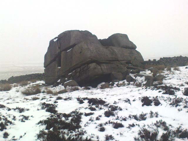
Supposedly the largest single boulder in Yorkshire, it possesses several legends, aligns with the sacred Pendle Hill in Lancashire, is an omphalos (centre of the universe spot) and has other good points too! My first visit here was near the end of the Great Drought of 1995. All of the streams and springs had dried up on the moors but, on the very top of this huge rock, measuring at least 8 feet by 4 feet across (and 3 feet deep) was a large pool of water, not unlike a bath, in which a couple of you could easily bathe (and do more besides, if the fancy takes you!). It was surreal! Water-boatmen and other insects were living in this curious pool on top of the rock. Yet all other water supplies for miles around had long since dried-up. It didn’t really seem to make sense.
Crystalline tunnel in the Hitching Stone
On the west-facing side of the boulder, about 8 feet up, is a curious deep recess known as the Druid’s or Priest’s Chair, into which initiates were sat (facing Pendle Hill, down which it seems the equinox sun “rolls”) and is believed, said Harry Speight, “to have some connection with Druidical worship, to which tradition assigns a place on these moors.” If you climb up and inside the Priest’s Chair section you’ll notice a curious “tunnel” that runs down through the boulder, about 12 feet long, emerging near the northern base of the rock and out onto the moor itself. This curious tunnel through the rock is due to the softer rock of a fossilised tree (Lepidodendron) crumbling away — and not, as Will Keighley (1858) believed, “the mould or matrix of a great fish.” When we visited the stone the other day in the snow, we noticed how the inner surface of this tunnel was shimmering throughout its length as if coated in a beautiful crystalline lattice (you can sort-of make this out in the image here, where the numerous bright spots on the photo are where the rock was lit up). Twas gorgeous!
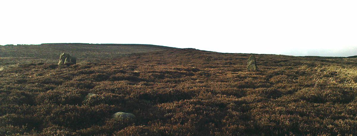
The Hitching Stone, looking north
The boulder lies at the meeting of five boundaries, and was the starting point for horse-racing event until the end of the 19th century. A short distance away “are two smaller stones, the one on the east called ‘Kidstone’, the other ‘Navaxstone’, which stands at the terminus of the race-course.” (Keighley 1858) Lammas fairs were also held here, though were stopped in 1870.
The cup-marked Winter Hill Stone a few hundred yards to the northeast, which I previously thought aligned with this site around winter solstice, but which happens to be a few degrees of arc off-line, would have indicated a very early mythic relationship, but this thought may now have to be put to bed. I’ve not checked whether the winter solstice alignment shown in the photo below (with the Hitching Stone being shown on the near-horizon as the sun rose on winter solstice, 2010, from Winter Hill Stone) would have been closer in neolithic times or not. Summat to check out sometime in the future maybe…
This aside, there is little doubt that this was an important sacred site to our ancestors.
Folklore
Winter Solstice sunrise, 2010 (from Winter Hill Stone)
Legend has it that the Hitching Stone used to sit on Ilkley Moor. But it was outside the rocky house of a great witch who, fed up by the constant intrusion the boulder made to her life, tried all sorts of ways to move it, but without success. So one day, using magick, she stuck her wand (or broomstick) into the very rock itself and threw it several miles from one side of the valley to the other until it landed where it still sits, on Keighley Moor.
A variation on the same tale tells that she pushed it up the hill from the Aire valley bottom. The “hole” running through the stone is supposed to be where our old witch shoved her broomstick!
About a metre tall and found standing near the bottom of one of the fields diagonally across from the old farmhouse of Laverock Hall, here’s another old stone which may not have a prehistoric provenance. It is seemingly unknown by all but local people and would seem to be an old rubbing post for cattle — albeit a small one! There seems to be no written accounts of this stone; though until all of the local field-name maps have been checked, we can’t discount the possibility that this is the “standing stone” described in early place-name records that was mentioned by A.H. Smith in 1963.
References:
Bennett, Paul, The Old Stones of Elmet, Capall Bann: Milverton 2001.
Smith, A.H., The Place-Names of the West Riding of Yorkshire – volume 6, Cambridge University Press 1963.
From Harden, go up Moor Edge High Side (terraced row) till you reach the top. Follow the path thru’ the woods on the left side of the stream till you bend back on yourself and go uphill till you reach the moor edge. Keep walking for about 500 yards and keep an eye out to your immediate left. The other route is from the Guide Inn pub: cross the road and go up the dirt-track on the moor-edge till you reach a crossing of the tracks where a footpath takes you straight onto the moor (south). Walk on here, heading to the highest point where the path eventually drops down the slope, SE. As you drop down, watch out for the birch tree, cos the circle’s to be found shortly after that, on your right, hidden in the heather!
Archaeology & History
This aint a bad little site hidden away on the small remains of Harden Moor, but is more of a ‘ring cairn’ than an authentic stone circle (a designation given it by previous archaeologists). An early description of it was by Bradford historian Butler Wood (1905), who also mentioned there being the remains of around 20 small burials nearby. When the great Sidney Jackson (1956; 1959) and his team of devoted Bradford amateurs got round to excavating here, he found “four or five Bronze Age urns” associated with the circle. His measurements of the site found it to be 24 feet across, and although the stones are buried into the peat with none of them reaching higher than 3 feet tall, it’s a quietly impressive little monument this one. About 20 upright stones make up the main part of the ring.
I’ve visited the place often over the last year or so since a section of the heather has been burnt away on the southern edges of the circle. This has made visible a very distinct surrounding raised embankment of packing stones about a yard wide and nearly two-feet high, particularly on the southern and eastern sides of the circle, giving the site a notable similarity in appearance and structure to the Roms Law circle (or Grubstones Ring) on Ilkley Moor a few miles to the north.
There is also the possibility that this ring of stones was the site described by local historian William Keighley (1858) in his brief outline of the antiquities of the region, where he wrote:
“On Harden Moor, about two miles south of Keighley, we meet with an interesting plot of ground where was to be seen in the early days of many aged persons yet living, a cairn or ‘skirt of stones,’* which appears to have given name to the place, now designated Cat or Scat-stones. This was no doubt the grave of some noted but long-forgotten warrior.
* The Cairn was called Skirtstones by the country people in allusion to the custom of carrying a stone in the skirt to add to the Cairn.”
However, a site called the ‘Cat stones’ is to be found on the nearby hill about 500 yards southeast – and this mention of a cairn could be the same one which a Mr Peter Craik (1907) of Keighley mentioned in his brief survey of the said Catstones Ring at the turn of the 20th century. We just can’t be sure at the moment. There are still a number of lost sites, inaccuracies and questions relating to the prehistoric archaeology of Harden Moor (as the case of the megalithic Harden Moor Stone Row illustrates).
Section of the inner ring
The general lack of an accurate archaeological survey of this region is best exemplified by the archaeologist J.J. Keighley’s (1981) remark relating specifically to the Harden Moor Circle, when he erroneously told that, “there are now no remains of the stone circle on this site” — oh wot an indicator that he spent too much time with paperwork! For, as we can see, albeit hidden somewhat by an excessive growth of heather, the ring is in quite good condition.
It would be good to have a more up-to-date set of excavations and investigations here. In the event that much of the heather covering this small moorland is burnt back, more accurate evaluations could be forthcoming. But until then…..
Pretty easy to find. Go along the Oakworth-Wycoller road, between Keighley and Colne, high up on the moors. When you get to the Water Sheddles Reservoir right by the roadside (y’ can’t miss it), stop! On the other side of the road walk onto the moor, heading for the walling a coupla hundred yards to your east (right). Where the corner edge of the walling ends, your standing stone is right in front of you! If for some reason you can’t see it, wander about – though beware the very boggy ground all round here.
Archaeology & History
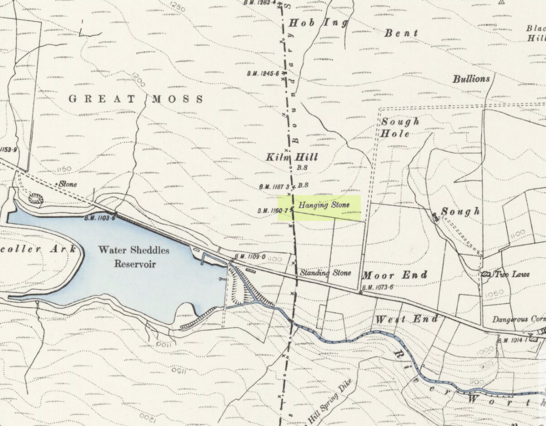
This seven-foot tall monolith, leaning to one side thanks to the regularly water-logged peat beneath its feet, stands on the Yorkshire-Lancashire. It is locally known as the Hanging Stone and the Standing Stone, but the name ‘Water Sheddles’ is a bittova puzzle. The place-names authority, A.H. Smith (1961) thinks it may derive from the middle-english word, shadel, being a ‘parting of the waters’ – which is pretty good in terms of its position in the landscape and the boggy situation around it. But ‘sheddle’ was also a well-used local dialect word, though it had several meanings and it’s difficult to say whether any of them would apply to this old stone. Invariably relating to pedlars, swindling or dodgy dealings, it was also used to mean a singer, or someone who rang bells, or a schedule, aswell as to shuffle when walking. Perhaps one or more of these meanings tells of events that might have secretly have been done here by local people, but no records say as such — so for the time being I’ll stick with Mr Smith’s interpretation of the word! Up until the year 1618 it was known simply as just a ‘standing stone’, when it seems that the words “Hanging Stone or Water Sheddles Cross” were thereafter carved on its west-face, as the photo below shows.
Cross carved on top of the stoneThe old stone, with its names carved for all to see
Whether or not this stone is prehistoric has been open to conjecture from various quarter over the years. Is it not just an old boundary stone, erected in early medieval times? Or perhaps a primitive christian relic? Certainly the stone was referred to as “le Waterschedles crosse”, as well as “crucem”, in an early record describing the boundaries of the parish of Whalley, dating from around the 15th century. This has led some historians to think that the monolith we see today is simply a primitive cross. However, sticking crosses on moortops or along old boundaries tended to be a policy which the Church adopted as a means to ‘convert’ or christianize the more ancient heathen sites. It seems probable in this case that an old wooden cross represented the ‘crucem‘ which the monks described in the early Whalley parish records.
Site marked on 1892 map
This monolith likely predates any christian relic that might once have stood nearby; although the carving of a ‘cross’ on the head of the stone may have supplemented the loss of the earlier wooden one. But it seems likely that this carved ‘cross’ was done at a later date than the description of the ‘crucem‘ in the parish records — probably a couple of centuries later, when a boundary dispute was opened, in 1614, about a query on the precise whereabouts of the Yorkshire-Lancashire boundary. After several years, as John Thornhill (1989) wrote,
“the matter was resolved on the grounds that the vast Lancastrian parish of Whalley had claimed territorial jurisdiction as far east as the Hanging Stone, thus the county boundary was fixed on the Watersheddles Cross.”
Water Sheddles stone looking SW
Certainly the stone hasn’t changed in the last hundred years, as we can tell from a description of it by Henry Taylor (1906), who said:
“The remains consist of a rough block of stone, leaning at an angle of about forty-five degrees against a projecting rock. The top end has been shaped into the form of an octagon, on the face of which a raised cross is to be seen. The stone is about six feet long and two feet wide, tapering to eleven inches square at the upper end, and appears once to have stood upright. Some local authorities have cut on it the words, ‘Hanging Stone or Waterscheddles Cross.'”
So is it an authentic prehistoric standing stone? Tis hard to say for certain I’m afraid. It seems probable – but perhaps no more probable than the smaller Great Moss Standing Stone found just a couple of hundred yards away in the heather to the west, on the Lancashire side of the boundary. Tis a lovely bitta moorland though, with a host of lost folktales and forgotten archaeologies…
Follow the directions to reach the Great Skirtful of Stones giant cairn (very worryingly being encroached upon, illegally [it’s a protected monument], by employees of Bradford Council digging tracks into its edges). Walk less than 100 yards to the east, down the slight moorland slope (Leeds & Otley Chevin are in the distance). You’re here!
Archaeology & History
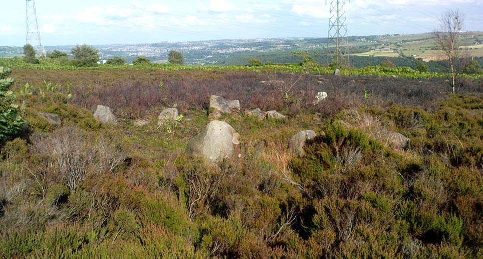
This is a very intriguing site. Intriguing because we don’t actually know what it is! It’s best seen at the end of winter, shortly after the heather-burning’s been done; but if there’s been no burning here, after a year or two it’s almost impossible to find!
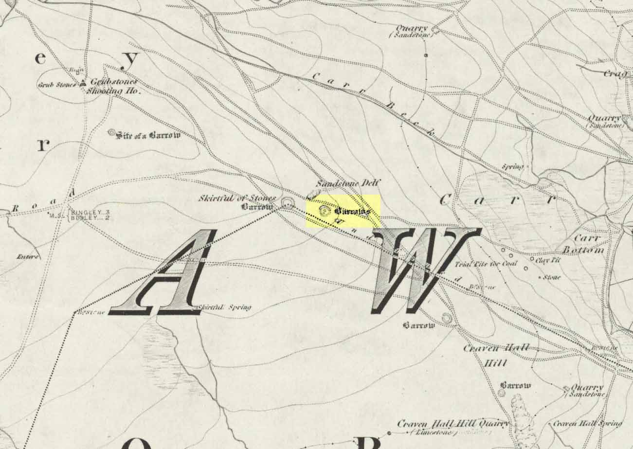
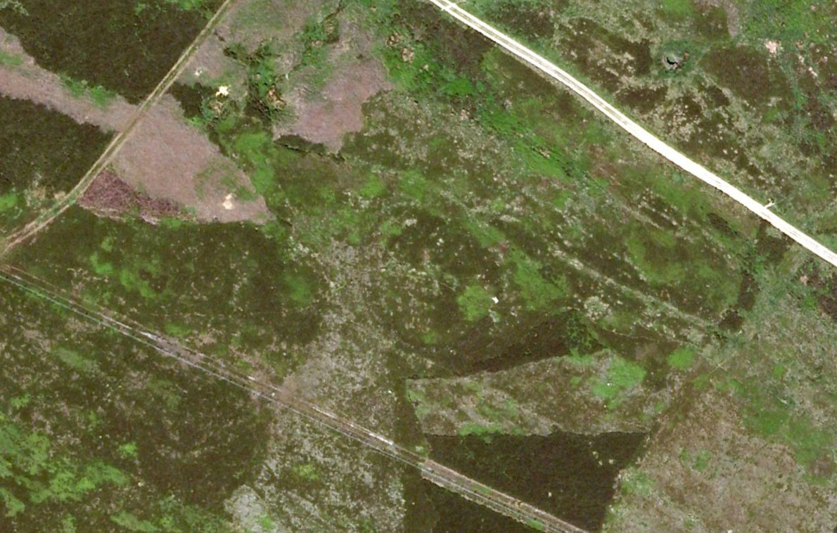
Great Skirtful Ring on 1851 mapColls’ 1846 plan
Despite it being only a short distance east of the Great Skirtful giant cairn, very little has been written about it (a surprise in itself!) – but this is down the failings of archaeological professionals in the area, who still neglect this incredible prehistoric arean. It was first described in Mr J.N.M. Colls’ (1846) survey of sites in the region, where he thought it to be a prehistoric camp. Several years later the Ordnance Survey lads visited here and deemed it to be prehistoric barrows, which doesn’t seem true. Nearly a hundred years later, the great northern antiquarian Eric Cowling (1946) who saw fit to describe it as an “enclosure” — so I’m copying his idea so I don’t get into too much trouble! Thinking it to be a Bronze Age monument, he wrote:
“On the main ridge of Rombald’s Moor and about eighty yards to the east of the Great Skirtful barrow, is a small circular enclosure with a diameter of twenty yards. There appears to have been an entrance on the eastern side, which is protected by a short length of banking to the east.”
Aerial image, 2002Aerial image, 2009
The “length of banking” he described didn’t seem apparent when we visited the site yesterday (23.3.09), but we intend a further exploration of this and the adjacent monuments in the coming weeks and hope to locate it!
Interestingly, the archaeologists Faull & Moorhouse (1981:1:103), in their otherwise fine survey, actually doubted this place as having any prehistoric status, without giving any reason why—which was a big mistake. No doubt they spent too much time in offices and board meetings instead of getting out a bit more! Unless evidence to the contrary can be strongly presented, this site must be classed as undoubtedly prehistoric in nature (Bronze Age or Iron Age certainly) and almost certainly had something to do with rituals of the dead.
Great Skirtful Ring embankmentSouthern edge of the ring
From outer edge to outer edge the ‘ring’ measures 102 feet across, N-S, and with a rough maximum 101 feet E-W, being diameter, being some 300 feet in circumference. When you look at the site at ground level it appears to be an almost perfect ring, consisting of an embankment little more than 2 feet high at the most, with entrances both east and west. However, as the aerial images show, the perfect circle aint quite so perfect! But at ground level, there’s a certain uniformity about it. The embankment is in very good condition around much of the ring, with only slight damage in certain parts. The western opening strongly implies a direct relationship with the Great Skirtful cairn — which would infer this monument to have more of a ritual nature rather than the simple domestic enclosure, inferred by Colls and Cowling. Adding to this we find a tumulus 100 yards east and the remains of several other cairns nearby, making the site almost hemmed in by death-sites. A prehistoric cemetery is a short distance further down the moorland slopes to the east. Add also the fact that the Burley Moor stone avenue runs immediately south and the death-motif has to be increased.
What do I think it is? Not sure! The thought that it’s a previously unrecognized henge has crossed my mind…but henge monuments aren’t things that I’m very clued-up on, so wouldn’t like to say for sure. If there are any university archaeology students out there who are into getting their feet dirty, give this site a look-over. It’s intriguing, in very good condition, and could do with an accurate ID!
References:
Bennett, Paul, The Old Stones of Elmet, Capall Bann: Chieveley 2001.
Colls, J.N.M., ‘Letter upon some Early Remains Discovered in Yorkshire,’ in Archaeologia, volume 31, 1846.
Cowling, Eric T., Rombald’s Way, William Walker: Otley 1946.
Faull, M.L. & Moorhouse, S.A. (eds), West Yorkshire: An Archaeological Survey – volume 1, WYMCC: Wakefield 1981.
Easy one this! Go up thru Baildon, on towards Baildon Moor over the cattle-grid. Take your first left and go up for several hundred yards past the reservoir until you reach the track on the left which takes you onto the Low Plain, Baildon Moor.
Archaeology & History
1845 plan of Cairns & Earthworks on Baildon Moor (after J.N.M. Colls)
In the year 1845, on the Low Plain on the western side of Baildon Hill, an intrepid archaeologist and historian, Mr. J.N.M. Colls, came across extensive earthworks and a number of prehistoric tombs in a very small area. Upon excavation, the ‘earthworks’ were found to be what sounds like neolithic walling running parallel to each other in a roughly north-south direction (north is the traditional direction for death). Scattered amidst these lines he found more than a dozen cairns and barrows, along with remains of “a circle, or ring.” Although the majority of what Colls wrote about has been destroyed, leaving only scanty remains of a once considerable archaeological arena, his lengthy description deserves being reprinted in full. He wrote:
“This level (the Low Plain) bears numerous traces of earthworks or other embankments running in many cases parallel with one another, at distances varying from 50 to 80 yards apart, and intersected by other works of similar construction. These earthworks can be remembered to have been from four to five feet in height; their bases nearly invariably appear to have been eight feet in diameter, composed of loose blocks of calliard, or close-grained sandstone, and earth. The greater part of the stone has been torn away to make and repair the roads of the neighbouring district; and the surface of the earth has been so nearly levelled that it is only by the scattered and disfigured remains, carefully delineated upon my plan, that any idea can be formed of their original character.
“In connection with these earthworks, and upon the north side of them, immediately above a steep fall to the next lower level (approx SE 1372 4020, Ed.), is a circle, or ring, formed originally of earthworks of precisely similar character, size and construction to those I have just described. The diameter of this ring is about fifty feet; its interior area is perfectly level; but the earthwork forming its circumference has been defaced and torn up for a considerable extent for the stone it contained. Circles of this nature have generally been termed druidical, from their presumed use as places of worship or sacrifice. I therefore opened its centre, in the hope of finding some trace of fire confirmatory of its character; and commenced clearing away a layer of peat earth, of from 10-11 inches in depth. I then found a layer of calliard boulders one-and-a-half feet in depth, the lower ones slightly burned, and resting upon a deposit of peat-ashes three inches in depth and from 2-3 feet in diameter (see Barrow No.8 in plan, Ed.). This I should have concluded to be the remains of a beacon fire, but, upon continuing the excavations, I found about three feet SSE of this deposit of ashes (at point b on the plan) a rude urn standing in an upright position, at a depth of two feet from the surface, a layer of calliard stones having been removed from above it, one of which appeared to have covered it. This urn was 12 inches in diameter and 9-10 inches in depth, of a circular or bowl shape, the upper stage of it being rudely ornamented by incised lines crossing each other at acute angles: it was filled with calcined bones (some remaining tolerably perfect), ashes and charcoal; and I selected some half-dozen of them as specimens, which Mr Keyworth, surgeon and lecturer on anatomy at York, has examined… He is of the opinion that they belonged to a very young subject, perhaps from 9-12 or 13 years of age; he thinks it possible however, that they may all have belonged to the same subject… The urn in which the were placed appears to have been rudely formed by the hand, without the assistance of a lathe; in substance about half-an-inch…it appears pretty evident that this urn has been formed of the black earth of the mountain and coal measures of which Baildon Hill is formed…
“A little to the west by south of the circle…are the almost obliterated remains of another circle (fig.9 on the plan), which I had not an opportunity of thoroughly examining; the slight traces remaining bear strong testimony of its character being similar to that of fig.8.
“Scattered over the surface of the Plain, and at irregular distances, cairns or heaps of stones, composed of bare sandstone and calliards (and not mixed with earth), frequently occur; they are generally about twenty feet in diameter and appear to have been originally 4 or 5 feet in height: these remains still require examination. In passing over them, I remarked that some of the stones of which they and the earthworks near them were constructed, had marks, or characters, but so rude that a doubt remains whether they may not have been caused by the action of the atmosphere on the softer portions of the stone.”
Urns found near Dobrudden
This final remark seems to be the very first written intimation of the cup-and-ring marked stones which can still be found amidst the grasses in the very area Mr Colls described. Sadly, much of the other remains shown in the drawing have been all but obliterated, or grown over. However, the decent concentration of cup-and-ring stones in this small area (see other Baildon Moor entries), highlights once again an associated prevalence of these carvings with our ancestor’s notions of death.
Sadly, year by year, the important neolithic and Bronze Age english heritage remains across this upland ridge are slowly being destroyed. The lack of attention and concern by regional archaeologists and local councillors, and the gradual encroachment of human erosion are the primary causative factors. Hopefully there are some sincere archaeologists in the West Yorkshire region who will have the strength to correctly address this issue. Under previous archaeological administrators, Bradford Council have allowed for the complete destruction of giant tombs, stone circles and other important prehistoric remains in their region—a habit that seems not to be curtailed as they maintain a program of footpath “improvements” on local moors without any hands-on assessment of the archaeology on the ground.
…to be continued…
References:
Baildon, W. Paley, Baildon and the Baildons – volume 1, St. Catherine Press: Adelphi 1913.
Barnes, Bernard, Man and the Changing Landscape, Eaton Press: Wallasey 1982.
Colls, J.N.M., ‘Letter upon some Early Remains Discovered in Yorkshire,’ in Archaeologia, volume 31, 1846.
From Keighley town centre, head north towards Cliffe Castle, but turn left beforehand and along Hollins Lane. Go past Hollins Hall for a few hundred yards and then through the gate on your left, then straight up the steep hill to the small woodland at the top. On the OS-map it’s shown as ‘Great Snowden.’ You’re here!
Archaeology & History
A standing stone found recently by Lindsay Lockwood to the west of Keighley, albeit on supposedly private—ahem!—land (a number of old locals tell you, quite rightly, to ignore this selfishness; but be careful of the land-owners here, who can be quite miserable). Tis less than four-feet tall but with a very noticeable female genital carving on its top western face. This carving however, is perhaps 200 years old at the very most. It’s in a quite beautiful setting aswell…
The Yoni or Cunt Stone, UtleyBuddhist scholar Steve Hart fondling the stone
What may be the remains of an old hut circle, or an old drained-out pond (a big difference, I know!), can be found about 100 yards northwest, and one – possibly two – ‘cairns’ can also be found in the scattered trees immediately to the northeast. An old ‘druid’s bowl’ (natural cup-marking into which rain-water collects) can also be seen on an adjacent earthfast boulder. Some folk might wanna allege a bullaun, but it’d be pushing it a bit I think. More recent walling and what appears to be stonework from more recent centuries (medieval) appears evident close by. Whilst below the hill we have the recently discovered Dragon Stone cup-and-ring carving just a few hundred yards away.
The setting is not unlike the beautiful little standing stone of Tirai on the slopes of Glen Lochay, where amidst the recently deserted village the short squat standing stone is found. You get the same sorta feeling of more recent going-on with this site aswell.
The carved ‘cunt’ gives an even more intriguing thought as to what the stone was used for, around Beltane perhaps, by folk like misself and other straightforward doods!
I wasn’t sure exactly what to call the stone after Lindsay had found it. However, due to the carved minge near the top, it seemed right to give the stone a name relative to the carving — and as we have a Devil’s Cunt in the Netherlands, I opted to call it something similar.* Although ‘cunt’ is an old European word for ladies’ lovely parts, the word ‘Yoni’ is an eastern title, which has become very acceptable in Western parlance. In recent years there has emerged a distinct aversion to using our own, old word for female genitals (indicating how detached people have become from even their own roots).
* of the name ‘cunt stone’: the word cunt itself, as explored eloquently in the fine study by Peter Fryer, Mrs Grundy: Studies in English Prudery (Corgi: London 1965), was the acceptable term for ladies’ genitals in the days when this carving was evidently done, so thought it a most applicable title.
Best approached from Haworth and then walking along the Bronte Way footpath onto the moors (ask at the local Tourist Info if you aint sure). A few hundred yards along, cross the ‘Bronte Bridge’ and keep following the footpath up until you get past the trees and get onto the moors. Once on the heathland, a few hundred yards along keep your eyes to the right and at least one of the two stones here will appear!
Archaeology & History
The original Cuckoo Stone
This is a fascinating little site that has been mentioned in a few old local history guides, including John Lock’s Guide to Haworth (c.1965). First described in 1852 and only briefly noted in passing by Horsfall Turner (1879), the place was previously thought to have comprised just one standing stone, but in recent years explorations by Mark Davey and I found there to be two standing stones close to each other. They are not marked on any maps and are unknown even to many local people. However, the place once had a bit of a reputation (see folklore) and seemed to be well known in the region when the cult of the Church was at its height!
Both of the stones are between three and four feet tall, but the westernmost of the two was probably much taller in bygone days – that’s because the top of the stone was vandalised in centuries past, presumably by some christians if the folktale is anything to go by! On the north-facing side of the western stone is the faint carved outline of an old cross, first described by local historians in the 1960s. It’s faint, but you can work it out if your eyes work properly! The newly-recovered (July 2005) easternmost stone is in two sections, with the very top of it having been hacked off in centuries gone by, as seen in the photos.
The second Cuckoo Stone, resurrected!
When we unearthed the previously unknown Cuckoo Stone (which was laid in the earth and covered with heather and peat), a small deposit of quartz crystals was found in the original socket beneath it when we came to stand the stone back in position. Question is: who put the quartz there? The original builders, or the nutters who knocked it down? And then we might ask: what was the reason behind placing a large handful of quartz beneath the standing stone?
In the heather beyond, about thirty yards to the north, we also find what looks like the remains of an old prehistoric tomb. If we make sense of the Cuckoo Stone’s folklore, we can safely assert that these monoliths were the spirit-home of the old dood/s buried in the tomb behind…
Tis a lovely little place…
There’s also something from that strange electromagnetic-anomaly region attached to this site, well-known to students exploring the physics of megalithic sites. When my lovely friend Mark – “grope me baby! grope me!” – Davey and I rediscovered the second Cuckoo Stone, Mark brought with him a device that measures fluctuations in electromagnetic radiation. The readings taken were fine just about everywhere (background, with minor fluctuations), apart from two very curious straight lines which ran either side of the burial mound down towards the two Cuckoo Stones, with radiation readings being between 10 and more than 60 times above background! The highest readings came from those closest to the burial mound, with levels dropping as we approached the standing stones. Such magnetic anomalies have been found at a number of megalithic sites in the UK, as described in Paul Devereux’s Place of Power (1989) and other books. But the fact that the anomaly lines here seemed to run in lines would be something that those ley enthusiasts would no doubt be intrigued by!
Folklore
The creation myth of this site tells that once, long ago, a great giant lived upon these old moors. He wasn’t a good giant though, from all acounts: robbing and persecuting those who would venture onto the hills hereabouts. The local people wouldn’t dare venture onto the moors and they long sought for a hero who’d be able to sort him out! This eventually happened and in a great fight, our unnamed hero caught and killed the old giant. But just as the giant was about to die, he used his ancient magick powers and, “with a magical groan, he did transform before them and became the Cuckoo Stone.”
But that wasn’t the end of the matter because, as our unnamed hero realised, knowing that the head was the seat of the soul, even in his petrified stoney state the giant may one day recover his life, and so he chopped off the top of the Cuckoo Stone and rolled it into the valley below, dismembering the ‘head’ from the giant, seemingly forever…
It is said that the winnings of this old giant, stolen from his countless victims, are hidden somewhere high upon these hills, awaiting the shovel of some fortunate treasure hunter!
The motif of this tale is universal and archaic, echoing traditional or aboriginal lore from elsewhere in the world. The tale is a simple one: originally the ‘giant’ was a local hero, chief or medicine man who lived on these hills and the Cuckoo Stones his petrified body, and with the incoming christian cult, the giant became demonised. It seems that the ingredient of the giant’s death may infer a burial of sorts and, a hundred yards behind the Cuckoo Stones (both of whom have had their ‘heads’ hacked off), is a mound of earth which, when seen after all the heather’s been burnt away, has all the hallmarks of a prehistoric tomb (it is seen in the top photo above, as the mound in the background behind the standing stones).