From Mytholmroyd, take the Cragg Vale road (B6138) up and up and up, until you get past the tree-level and the hills open up on either side of you. Take note of the farmhouse on the right-hand side of the road a half-mile on and park where you can. Walk down the track by the farmhouse (known as Washfold Road) and cross the stream at the bottom. OK – from here walk straight up the hill in front of you! (not along the footpath) In less than 100 yards it levels out and you’re onto the moorland proper. From here walk straight west for about 400 yards. If you deviate a little, don’t worry. You’ll see this small upright stone as you’re getting closer, seemingly in line with several other rocks, almost giving the impression you’ve come across a stone row. Good luck!
Archaeology & History
The slim upright
This small squat standing stone is just over three feet tall (1m), about 10 inches thick and 3½-feet across. Leaning at an angle into the ground, this broad but thin monolith has sunk some distance into the moorland peat.
It was located on February 15, 2011, in the company of Dave Hazell (pacemaker in tow!) on our first sojourn of the year. It hasn’t been mentioned in any previous surveys and aint in anyway what you’d call impressive. Nearby are the early remains of old walling north, east and west of here (one of them being a small enclosure of some type), for which I can again find no other references. What looks distinctly like the remains of a large cairn isn’t far away either. However, it may be that some of the remains up here are medieval in nature and it would be of benefit if someone who specializes in remains from that period could have a look here. The equally curious Turley Holes standing stones can be seen a half-mile northeast of here.
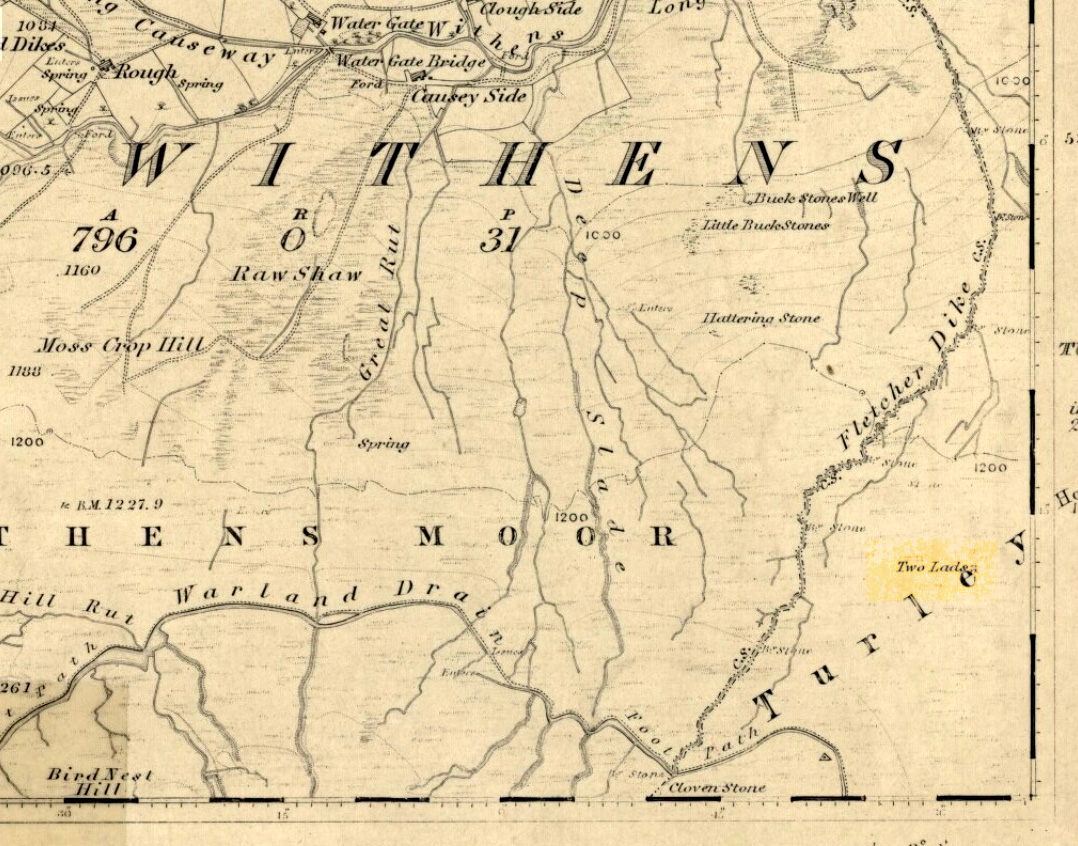
Best way here is, from Mytholmroyd go up the Cragg Vale road for a coupla miles, then turn right and heading down, then up, towards Withens Clough reservoir. Once there, walk onto the moor to your left (south) until you’re on the ridge above you. Keep walking until y’ see the rocky cairn-like creatures stood in isolation on a flat moorland plain.
Archaeology & History
Two Lads – on a dark, rainy, windy day
Truly weird spot this one, but I love it! Seemingly miles from anywhere, it’s one helluva walk to most folk, but utterly worthwhile when your arrive. On a clear day you can see for miles and the landscape is adorable! On a cloudy rainy day, the feel of the place changes if you take care to stay with the site, saturated, meditating (as no other people ever turn up when She’s like that – so you and the place get the best from each other!).
The site comprises of two boulders, each crowned with a cairn of stones. The westernmost one of the two (SD 98392 22111) is intriguing as it has, carved upon the rock beneath the stone cairn on the northwestern edge of the stone, what looks like a singular cup-marking, plus a large water-worn bowl on its northern edge, and a very distinct deeply-cut cross-base, several inches deep, near the northeastern corner of the rock. This cross-base seems slightly more rectangular in form than square; although the large covering of stones makes an accurate ascription difficult. If this cross-base and cup-markings are authentic, we would have here a clear example of the christianization of a previously heathen site.
A cursory examination of the easternmost of the Two Lads (SD 98397 22117) doesn’t indicate any artificial workings on the rock surface.
Two Lads on 1853 OS-map
Although the two ‘cairns’ on top of these two rocks are not prehistoric in nature, about 20 yards behind the Two Lads (south) may once have been the severely denuded remains of a once large prehistoric cairn. Although the position in the landscape is perfect for such a construction, this is somewhat tentative, it’s gotta be said! Further examinations are obviously necessary here.
The studious A.H. Smith (1961-63) believes that a field-name record from 1624, describing some ‘Lad Stones’ in the parish of Heptonstall relates to this site. We know with certainty however, that this site was first illustrated on Greenwood’s 1771 map of Yorkshire, then highlighted on more recent 19th century Ordnance Survey maps as ‘cairns.’
Folklore
Drawing of the Lads in 1877
The creation myth behind this place is that two lads were walking over the moor in midwinter and got caught in a blizzard. Losing all sense of visibility they tried to shelter from the wind and snow by hiding behind these rocks, but perished. Sometime later their bodies were found and the curious “cairn” of rocks were mounted onto the boulders to mark where they’d died. This is a folktale we find at many other old stone remains on the hilltops of northern England and Scotland.
The Two Lads seems to be very close to a midwinter alignment (or izzit a lunar standstill line?), linking it with the huge Rudstoop Standing Stone and, eventually, Robin Hood’s Penny Stone on Midgley Moor – which might be the root of the folktale. (i.e. midwinter, snow, death) Any archaeoastronomy buffs out there wanna check this one out? Then we can confirm or dismiss it.
References:
Anonymous, “The ‘Two Lads’, Withens Moor,” in Todmorden & Hebden Bridge Historical Almanack, T. Dawson: Todmorden 1877.
Bennett, Paul, The Old Stones of Elmet, Capall Bann: Milverton 2001.
Smith, A.H., The Place-Names of the West Riding of Yorkshire, Cambridge University Press 1961-63.
Another one of those rare cup-marked stones from Cornwall, once again found in association with a burial— but once again destroyed, this time by having an airfield built over the tomb! This “cup-marked and perforated slab” was said by Paul Ashbee (1958: 192) to have been unearthed “by Mr C.K. Andrew” in 1941 when he was digging in the Nancekuke round barrow. Yet an earlier reference to the same site by Mr o’ Neil (1948: 26) told that “the grave was rifled c.1926, but in the ditch there were found traces of a Bronze Age wooden shovel and a perforated and cup-marked slate.” For any students studying this arena, the correct date would appear to be the earlier of the two.
I’ve not been able to locate any decent photos or diagrams of this small cup-marked stone and would truly appreciate an illustration of it if anyone could get hold of one.
References:
Ashbee, Paul, “The Excavation of Tregulland Burrow, Treneglos Parish, Cornwall,” in Antiquaries Journal, volume 38, 1958.
o’ Neil, B.H. St. John, “War and Archaeology in Britain”, in Antiquaries Journal, volume XXVIII, January-April 1948.
To get here, follow the same directions to reach its nearby colleague of Carse Farm south — but instead of walking down the track to where its companion is found, this small ring of stones is found a coupla hundred yards into the first field by the roadside. Unless the field’s fulla corn (in which case, give it a miss cos even if you do find it, you won’t be able to make much out), y’ can’t really miss it!
Archaeology & History
As with its nearby companion of Carse Farm south, this small “ring” of four stones is found along the Tay valley floor and, though cited as a stone circle in many archaeology tomes, should more accurately be defined as a cairn circle of sorts. Structurally akin to other four-posters, it reminded me of a distant companion in North Yorkshire more than 200 miles south: the Druids Altar at Bordley, which is also a robbed prehistoric tomb and not a stone circle. But it’s a fine little site sat amidst the majestic temple of surrounding hills on all sides, bar east, where the Tay valley reaches into the distance.
Faint cup-marksCarse Farm, looking north
Like its damaged companion in the field below, some of the stones in this circle also have well-defined cup-markings on top of the uprights; although when we visited here, low cloud and late daylight conditions prevented us from getting good images of the cup-marks concerned (as the photo of one of them here illustrates). The cup-markings are, curiously, carved on the top of the small standing stones.
Described briefly in Alexander Thom’s Megalithic Rings (1980), he regarded its geometry as “circular” in structure. Aubrey Burl (1988) gave the lengthier archaeological history of the site, telling:
“On the ‘carse’, or lowland…this 4-poster was excavated in 1964. When Coles saw it in 1907 only three smallish stones remained standing although “it seems clear that at this site there were originally four Stones as in so many other Perthshire groups”… The SW stone was missing but halfway between the NW and SE stones a long, thin slab lay half-buried.
“Coles noticed that there were cupmarks on the tops of both the NE and SE stones. The SE had three carvings but the top of the NE had no fewer than 17, the largest ‘cup’ being 4 by 3½in (10 x 9cm). In the group were two ‘dumb-bells’. In the same field the farmer had dragged away a buried stone which was also cupmarked.* (my italics, PB)
“Of the three standing stones, the NE is 3ft 11in (1.2m) high; the SE, 5ft 1in (1.6m); and the NW, 4ft 1in (1.3m). These heights…are almost double those cited by Coles (1908: 126).
“”The 1964 excavation discovered the SW stonehole. The 5ft 10in (1.8m) long stone lying at the centre of the 4-Poster was erected in it, a task made easier by the fact that its base had been keeled… The base was unweathered showing that the stone had been toppled in quite recent times as had the stones of the two Fortingall 4-Posters…3¾ miles to the WSW. The four stones stood at the corners of a rectangle 12ft by 8ft (3.7 x 2.4m) on a long ENE-WSW axis. They also stood on the circumference of a circle 14ft 5in (4.4m) in diameter.
“A tapering pit was discovered against the inner face of the NE stone, about 2ft 6in (76cm) across and 1ft 2in (37cm) deep. It was filled with cremated bone and sticky black earth and charcoal. At the bottom, a collared urn lay on is side, its rim decorated in geometrical designs. A flint flake lay near it. Within the 4-Poster there were three shallow pits, two between the NW and NE stones, another between the SE and SW. Their edges were clean and they had been backfilled with brown loam. The excavators thought they might have “been used for stabilising props during the erection of the stones.” …As the heaviest block, that at the NW, weighed about 6 tons it would have required 20 to 30 people to drag it upright…and the use of such props would have made their insertion safer.”
Unless the people building this site were dwarves, we’ve gotta re-assess this latter remark (which Burl quotes from the earlier archaeologist’s report from the 1960s). Having personally been involved with the creation of modern stone circles with stones larger than the ones here, we know that the uprights here could have been erected by 8-10 people at the very most.
Archaeology and folklore records describe many other prehistoric sites along this section of the upper Tay valley, but it’s also very likely that other “circles” or cairns of similar structure to the two known at Carse Farm once existed close by that are not in modern literary accounts.
References:
Burl, Aubrey, Four Posters: Bronze Age Stone Circles of Western Europe, BAR 195: Oxford 1988.
To get here, follow the same directions as you would to reach the curious Green Plain settlement; but just before you reach that, you’ll notice this rather large boulder known as the Eagle Stone right in front of you next to the ever-decreasing stream. Wander down and give it a fondle — you can’t really miss it!
Archaeology & History
Cupmarks on top (image by Graeme Chappell)
Curiously not included in Boughey & Vickerman’s rock-art survey (2003), this large boulder stands just below the ancient ford which crosses Sun Bank Gill and is pitted with a number of cup-marks on its top (though not the 38 we counted when Graeme Chappell and I in the early 1990s), plus a large “bowl”, not unlike the Wart Well on top of Almscliffe Crags and other such sites. Although some of the cups seem natural, others are artificial — as even an English Heritage rock art student could tell you! A small cluster of ‘cups’ are on top of the stone, but a number of them have been etched onto the sloping southern face; a curved line running across the rock-face towards these cups may be natural.
The straight track above you was known as Watling Street in bygone years and was the old Roman road running between Ilkley and Aldborough.
Pretty easy to find – assuming it aint at the height of summer and the crops are approaching maturity, otherwise you’re only gonna see its head! But, this aside: from Aberfeldy, take the B846 road over the river bridge that bends you along the valley of the River Tay towards Appin of Dull. After some 2 miles you’ll pass the right-turn up to Dull. Go past this for another coupla hundred yards or so, watching out for the left-turn down towards the farmhouse of Carse and park up where you can (if you go past it, there’s the second turn up to Dull, again on your right, where you can turn round). As you walk down the track towards Carse Farm, watch out on your right in the field below Carse I, in the second field down. You can’t really miss it. (and the farmer here is spot on if you ask to check the stone – as long as the crops aint growing)
Archaeology & History
Although all that’s left of what is thought to have been a once proud stone circle is the singular upright standing stone in the middle of the field. Aubrey Burl (1988) thought that this was one of the typical “four poster”rings that scatter our isles, but I’m not so sure misself. There were other stones associated with the site when Burl described it, but these were covered over in our visit here a few months back — which is a pity, as two of the stones are reported as possessing cup-markings (if/when we revisit the site, I’ll try get some images of the respective stones and add them on TNA as individual carved stones). The site gives the distinct impression of it having a funerary character of some sort and not a true stone circle — and this was strongly suggested by some of the finds inside the “ring”, described below.
Fred Cole’s old drawingAubrey Burl’s groundplan
Both this and its associated “circle” a few hundred yards away — known as Carse Farm north — sit on a flat level of ground in the Tay valley, with rounded hills all most sides. This landscape setting was obviously of some importance to the people who put the circle here in the first place but, not living in the region, it’s difficult to assess the mythic relevance some of the hills will have obviously played in the siting of these stones.
In bygone days, it was reported that the much of the site was ploughed away due to agricultural excesses, so there was obviously much more to it in earlier centuries. Describing the solitary stone that’s left today, along with the earlier excavation results, Mr Burl (1988) wrote:
“The stone still standing, of quartziferous schist, is 6ft 3in (1.9m) high. Its longer faces are aligned NW-SE. 32ft 6in (9.9m) to its SW is a large prostate block, sub-elliptical and about 8ft long and 4ft 3in wide (2.4 x 1.3m). It has probably fallen outwards. (my italics, PB) If so, when standing near the top of its inner face were four cupmarks in a cross pattern.
“About 32ft ((9.8m) to its NW is a fallen and enormous schist slab, 11ft long and 5ft wide (3.4 x 1.5m). It also appears to have toppled outwards. Near the bottom of its inner face are two cupmarks. The situation of these three stones suggests that they once stood at the corners of a rectangle some 32ft (9.8m) square, the pillars of a huge four-poster nearly six-times the national average and with an internal area ten times bigger than the small 4-poster (Carse Farm north, PB) just to its north.
“Excavation in 1964 found the socket from which the great prostrate slab had been dragged… Cash (1911) had noted the presence of a small stone inside the ring about 20ft (6.1m) west of the standing stone. It proved to be 4ft (1.2m) square with a carefull-dressed face. It had been set upright, standing about 1ft 4in (41cm) above the ground. Three sides of the worked face ‘had been carefully chiselled away to a straight edge.’ It may have been a slab lining the inner central space of a destroyed ring-cairn. Burnt bone was found near it. There was also a rounded river pebble with a worked hollow on one side…”
Folklore
Carse Farm stone
Stewart (1964) described the site as having been “christianized” not long ago, by having the northernmost standing stone in the ring removed. This is intriguing inasmuch as “north” is the place of greatest symbolic darkness in the pre-christian mythos, and represented death and illumination in magickal terms. North was also the point taken by witches and shamans in their excursions into Underworlds, usually via the North Star, which tethered the Earth to the heavens (see Godwin’s Arktos [1993], and Grant, The Magical Revival [1973]) In the removal of this northern stone for the reasons given, that implies some magickal events or folklore were in evidence here when this took place. Anyone got any further information along these lines, or has it long since been subsumed?
References:
Burl, Aubrey, Four Posters: Bronze Age Stone Circles of Western Europe, BAR 195: Oxford 1988.
Follow the same directions to get to Bordley’s Druid’s Altar circle. Where the little rough car-parky-bit happens to be by the cattle-grid, look up the sloping field where the wall runs up in a line and follow it up on foot. A coupla hundred yards up you’ll see a small craggy outcrop in front of you and another line of drystone walling in the corner. Just below this craggy outcrop you’ll notice a raised embankment comprising a line of small rocks running along the edge of the hill. This is the first bitta prehistoric walling that makes up a part of the settlement system. From hereon, follow y’ nose along and up the hill and look around. The settlement’s all around here!
Archaeology & History
This is quite an extensive area of prehistoric (seemingly Iron Age) enclosures on the top and around the edges of the unnamed rocky peak at the top of the large open Lantern Holes field. I’m not aware of any excavation work that may have taken place at this site, so please excuse me of any errors in the description that follows. (if anyone’s got an excavation report of the site, I’d love to read it!)
As with the many other settlements and enclosures in this region, much of it comprises of extensive stonework built up into and against the geological limestone bedrock either side of this hilltop site. Huge lines of prehistoric walling, measuring anything between one and three yards across, runs for hundreds of yards in and around this set of enclosures. We also find several distinct and well-preserved examples of old hut circles (one of which appears to have been re-used as a sheep shelter in more recent centuries) dotted around the edges and in the middle of larger sections of enclosed stone walls. This is all very impressive when you consider it was done a coupla thousand years back!
Walled enclosure on south sideWalling along SW edges
Very similar in design to the prehistoric settlement enclosures on the other (south) side of the valley at Hammond Close Pasture, above the Druid’s Altar, though more extensive. Measuring roughly 340 yards (311m) along its longer southeast-northwest axis, and nearly 280 yards (254m) from east-to-west, the uppermost parts of the site have at least seven separate large elliptical ‘enclosures’ built within the rocky enclaves, made up of typical Iron Age wall systems: a series of large upright monoliths packed up by smaller packing stones all along the length of the walling (using a system that still prevails today in drystone walling techniques on our upland moors). A couple of the photos here illustrated the walling very well and give you an idea of what to look out for if you’re out wandering the region, looking for old sites.
Although the walling we see today is barren and easy to spot, remember that in the time when people built these great structures, you wouldn’t have been able to see them, as they’d have been deliberately covered over and camouflaged with dressed earth and plants. In watching people emerging from these enclosures, you’d have got the distinct impression that they literally came out of the hill itself: a motif well-known to folklorists in relation to the origin of faerie-folk and other ‘little people.’
We need to go back up here and explore this settlement a bit more, as there’s tons more to be seen. And if anyone knows of any surveys that have already been done of this site, it’d be good to read the reports, preliminary or otherwise. A rough-camping weekend is planned on the tops at the break of Spring – so contact us if you’re into joining us for the amble. I reckon there’s gonna be other sites hidden in the landscape up here that even Arthur Raistrick missed out on!
…to be continued…
References:
Raistrick, Arthur & Holmes, Paul F., Archaeology of Malham Moor, Headley Bros: London 1961.
From Malham village, take the winding uphill road up Malham Rakes (not the Malham Cove road). If you aint sure, ask a local. Get to the top of the long winding road and, a mile on, you meet with another single-track road on the top level known as Street Gate. Stop here, then head across the grasslands on the left-side of the road, southwest. There are a couple of footpaths running over the land here: I wouldn’t say it makes much difference which one you take as they take you in the right direction. You’ll eventually meet the old craggy hilltop with the drystone walling down t’other side of it. You’re here!
Archaeology & History
The history of this region seems to have been covered to a great deal by the likes of Arthur Raistrick and his mates, though I can’t find a specific entry in mi library about the remains we’re looking at here. Surrounding the edges of the small hill, as can be seen in the aerial photo here, walling has clearly been built up around it, with considerable remains still visible at ground level, as indicated in the photos aswell.
Eastern edges of enclosureEastern walls, looking north
A settlement or large stone-walled enclosure, lying primarily on the north side of the drystone wall, measures approximately 82 yards north-to-south, and roughly 78 yards (72m) east-to-west, with a rough circumference around the outer edges of its rough elliptical outlines of more than 270 yards (250m). Along the walled edges can clearly be seen several ‘hut circle’ remains: one in particular at the northeastern side and, more prominently, at the southeastern side, are in reasonably good states of preservation. The northeasterly hut circle measures approximately six yards across. The stone walls of this circle are more than a yard wide. The ‘hut circle’ on the southeastern corner are more prominent and is in a better state of preservation, but much of the structure has of course been ruined to build the adjacent, more modern, drystone walls. This circular structure is larger than its counterpart on the northeast, measuring some 13 yards across.
The southern edge of the main settlement walling has been built up against and onto a large length of bedrock running roughly east-to-west. This inclusion of local geological features within man-made settlements and houses is a feature found all over Malham Moor and adjacent areas, for many miles around here. (see the Hammond Close settlement, for example) The southernmost section of the Torlery Edge settlement is in a reasonable state of preservation, as is the length of walling along its eastern edge. Along the northern section of the settlement it seems that an internal enclosure feature has been built (“perhaps for cattle?” would be the archaeologists usual query); whilst the western edges are the least visible part of this monument.
Hut circle on southern edgesHut circle, looking north
If we now jump over the drystone wall running along the southern edges (and visible in the aerial photo above), we can see a series of six, perhaps seven, hut circles, all adjoining each other and running along the line of the wall. Some of these are in a very good state of preservation and an excavation of these sites might prove fruitful. (unless it’s already been done – does anyone know?) Two of these hut circles have entrances clearly visible. They are all roughly the same size and structure, with average diameters (from outer wall to outer wall) of 7 yards. They consist of a rough ring of small upright stones, packed with smaller rocks and (in bygone times) peat and wood. Sheltered from the north winds by the ridge above it and the extensive ancient enclosure walling (not the drystone, which in itself is very old), this row of prehistoric buildings were probably for members of the same tribal group.
Without excavation it’s difficult to date these hut circles, but they would probably have been used between the Bronze Age and Romano-British period. There is every likelihood they were also used up to the medieval period, as this land was acquired (i.e. stolen) from local people by the Church and their law-bringers. We know that much of the landscape hereabouts was possessed by Fountains Abbey in the 12th century, who made extensive use of the area for their cattle; and we find considerable evidence scattering these hills of medieval archaeological remains.
Although the site is catalogued as a separate site from, say, the settlement remains and enclosures we find at Combe Hill, Prior Rakes, New Close, and other field areas close by, this individual archaeological site must be assessed as part of a greater collective series of settlement remains hereby. Instead of looking at this as an individual settlement, its relationship with the others in the vicinity needs re-evaluating and contextualizing and set within a wider and more realistic vision. Whilst appreciating that detailed modern excavations have yet to be done in this region on a scale that is required (as with many of our northern archaeological landscapes), it is probable that this singular settlement was part and parcel of what was once a prehistoric city.
If you visit this particular site, spend a few days looking round at the many other settlements and prehistoric religious sites in the area. And don’t forget to look and enquire as to why the Romans came and built a huge monument near the centre-edges of this domain of our prehistoric ancestors. Tis a fascinating arena indeed…
References:
Dixon, John & Phillip, Journeys through Brigantia – volume 2: Walks in Ribblesdale, Malhamdale and Central Wharfedale, Aussteiger: Barnoldswick 1990.
Raistrick, Arthur & Holmes, Paul F., Archaeology of Malham Moor, Headley Bros: London 1961.
Follow the directions to reach the Herder’s Cross, not far away. Standing on the Herder’s Cross stone, look across the fields to the north (away from the farmhouse on the hill below) and you’ll see a nice-looking stream a coupla hundred yards ahead of you. Crossing this stream you see the large boulder, which you can see clearly if you’re stood on the Herder’s Cross. That’s where you’re heading!
Archaeology & History
A curious entry inasmuch as I’ve found no other references to the place. It’s an obvious cross-base, albeit very worn, cut onto the top of this large boulder, as you can see in the photo. What may be a singular cup-marking (if you’re a New-ager, or work for English Heritage that is!) is on the western side of the rock — but without additional markings on the rock, this has gotta be questionable.
Dodgy cup-marking on top!Shallow cross-base
The cut ‘square’ measures eight-inches both sides, but it seems that the cutting on the north-eastern sides of the base was never finished. The depth of the cross-base is also very shallow, only an inch deep. There seems to be a distinct possibility that this particular stone was initially chosen as a wayside cross marker, then for some reason perhaps moved to the position of the Herder’s Cross in the fields 420 yards (383m) to the south of here.
Clifford Byrne (1974) suggested that the pathway hereby was an ancient routeway that led towards the Emmot Holy Well, three-quarters of a half-mile down the hillside from here. Any further info or thoughts on this side would be most welcome.
References:
Byrne, Clifford, A Survey of the Wayside Crosses in North East Lancashire, unpublished manuscript, 1974.
The site is situated in a natural hollow just above a steep sided ravine known as Scotsman’s Wood through which a stream flows. The location in the hollow obscures all surrounding views of the East Lancashire Pennines and the Billinge Hill massif. The near surrounding area is on a natural sandbank created by the western shore of the post-glacial ‘Lake Accrington’.
Archaeology & History
During the early spring of 1996, grave digger Grant Higson, whilst excavating a new grave, uncovered course fragments of pottery displaying a herringbone pattern and other material. Grant stopped work immediately and alerted Blackburn Museum worker Maggy Simms, who gathered together the shattered remains and brought in Lancaster University Archaeological Unit for identification. They identified the fragments to be a Bronze Age Urn some 12 inches in height, decorated with a herringbone pattern and containing bones and ashes of several cremations, some stained green by some copper object that had disintegrated over the years. The burial was assigned to c. 1500 BC, a period of history referred to as the Bronze Age. The urn and its contents are now held by Blackburn Museum. A geo-physical survey was undertaken by the Unit on the surrounding areas that displayed undulation of the ground surface but nothing was found, the undulations deemed natural features. No archaeological report or radiocarbon dating has been made to date by Blackburn Museum Service, the Lancaster University Archaeological Unit being now defunct.
During August 2009, I visited the site and was fortunate to meet with Grant Higson who not only showed me the location of the find, but also described the geological formation of the cemetery area.
The urn found is typical of the well developed Pennine urns recovered from the Anglezarke, Bleasdale and Burnley districts and a date of 1500+250 BC is more than likely cet. par.
Given the ‘sheltered’ location of the find I would ascribe the site as one of a primary domestic nature, the burial being a secondary feature: primary tumulus burials in prominent locations being the sole preserve of the ruling aristocracy. What we are looking at is a hearth burial within a communal living hut: following the Indo-European custom, the dead were given to the Earth inside the human habitation. The dear departed, who had been so close to the family group in life, had to remain among them in death also and share the family’s joys and struggles, food and drink. While living they had enjoyed nightly rest under the roof of the communal hut, dead they slept the eternal slumber beneath the domestic heart.
This site is noted by ’TheElf’ on The Modern Antiquarian. ‘TheElf’ goes on to mention, “I saw what could possibly be a standing stone, some 200 metres north east of the cemetery.” I located this stone (SD 648 273) and found it to be a broken 17th century gate-stoop for pole fence – a gate post with a series of holes used to create a ‘heck’, being an adjustable series of pole bars in lieu of a gate.


")


