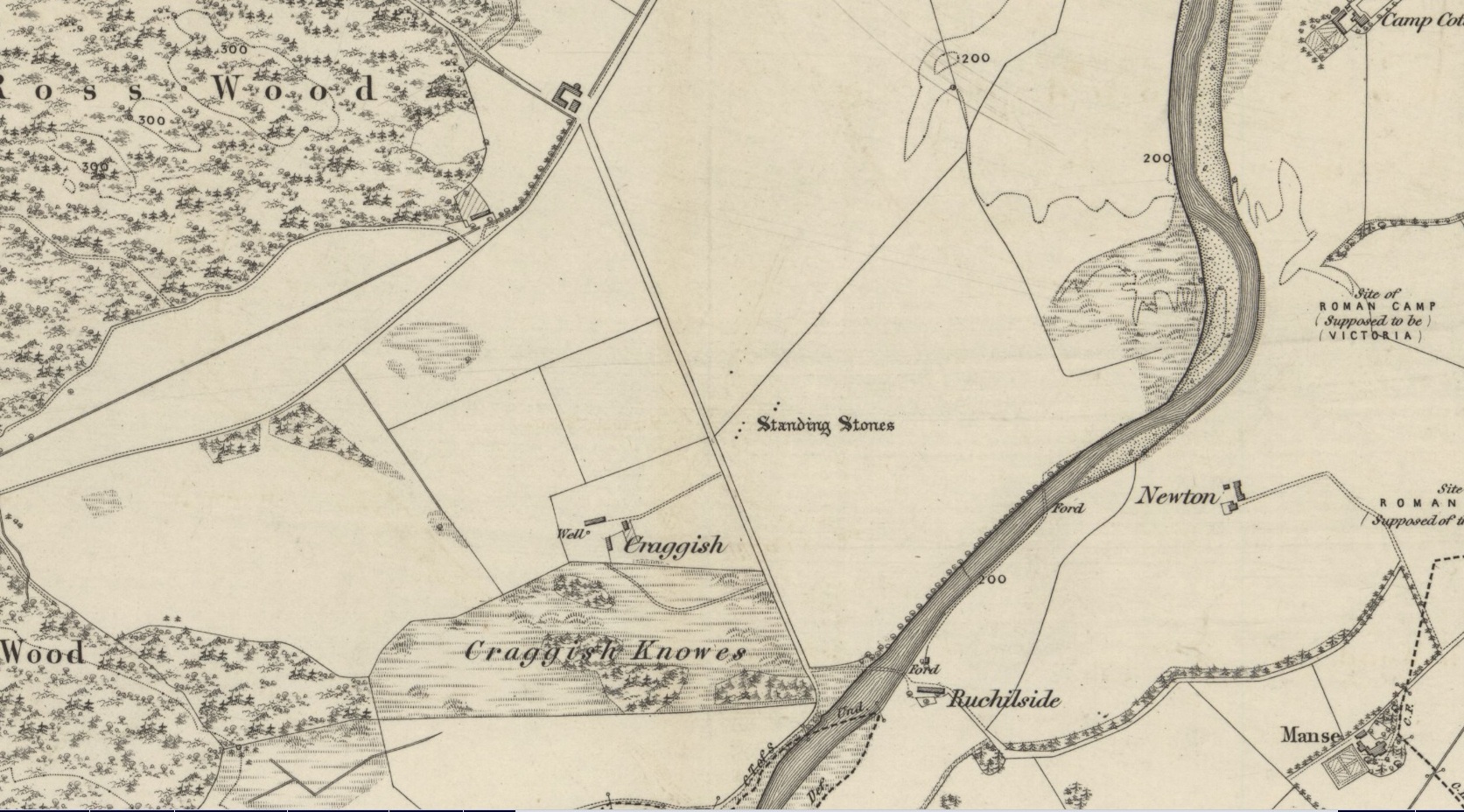
Standing Stones (destroyed): OS Grid Reference – NN 7643 2086
Archaeology & History
Site shown on 1886 OS-map
Highlighted on the 1866 OS-map was an impressive cluster of standing stones that sadly met their demise sometime around at the end of the 19th century. They were mentioned to “still exist” when the local writer Samuel Carment passed them in 1882, but had been destroyed by the time the Ordnance Survey lads resurveyed here in 1899. Altogether there were at least six of them, standing aligned sharply northeast-southwest and were described in one of Fred Coles’ (1911) essays, who lamented their passing. Listed in the stone row surveys by Burl (1993) and Thom (1990), the prime description we have of them was by Cole himself, who told:
“This site has also been wantonly bereft of its group of megaliths. Up to so recent a date as 1891 there were several. These were shown on the (Ordnance Survey map) as three in one line and two in another, on a field about one furlong NE of Craggish farmhouse, close to the road coming down from Ross, and nearly a quarter-mile NW of the ford across the Ruchil at Ruchilside.”
In Finlayson’s (2010) colourful survey of the local megaliths he told that the stones,
“Stood, by the road, in what is now ‘The Whinney Strip’: a boulder-strewn strip of land 20m wide dividing up otherwise flat and even grazing land.”
References:
Burl, Aubrey, From Carnac to Callanish, Yale University Press 1993.
Cole, Fred, “Report on Stone Circles Surveyed in Perthshire, Principally Strathearn,” in Proceedings of the Society of Antiquaries, Scotland, volume 45, 1911.
Thom, A., Thom, A.S. & Burl, Aubrey, Stone Rows and Standing Stones – 2 volumes, BAR: Oxford 1990.
Acknowledgments: Big thanks for use of the early edition OS-map in this site profile, Reproduced with the kind permission of the National Library of Scotland.
Go along the A977 road out of Powmill village towards Crook of Devon, and as the road swerves uphill, past the Powmill Milk Bar on the right-hand side of the road, take your next right. Go along this small country lane for a mile or so, past Maidenwells Farm; then as you go uphill, stop at the very top. Look in the field on your left, where a small round clump of trees are surrounded by circular walling. The cairn’s inside the protective walling.
Archaeology & History
This Bronze Age tomb sits quietly amidst the ring of trees and walling which give the site cover and protection and, of course, an excellent view of the landscape for the spirit of whichever ancestor lives here. The place seems to have been described first of all in the Old Statistical Account of the area, in 1796, where they told:
“In the middle of Carleith are the ruins of an old building, perfectly circular, and nearly 24ft in diameter. Not long ago, the proprietor ordered this ground to be planted, and the stones were dug up to make a dyke. Two stone coffins were found each 4 feet long by 3 feet broad, and contained some human bones and teeth.”
The cairn’s within the trees…
Today, the overgrown remains of the cairn measure roughly 10 yards across, with the beeches reaching their great roots into and around the old tomb. The sides of the stone cist are still visible amidst the undergrowth. It was measured and described in a letter to the Ordnance Survey by J.S. Nichol in 1959, who thought there may have been more than one tomb here.
Folklore
Although we don’t know for certain, one of the legendary witches known as ‘Meg of Aldie’ was said to frequent an old site close to where she lived – perhaps the Carleith cairn. The site is a damn good contender for such heathen rites!
References:
Simpkins, Ewart, County Folklore – volume VII: Fife, Folklore Society: London 1914.
Settlement (destroyed): OS Grid Reference – SE 309 336
Archaeology & History
Absolutely nothing is left of the large series of ancient earthworks that were reported to have existed near the very centre of Leeds by Ralph Thoresby, James Wardell and others in the 18th and 19th centuries. Although we do not know with certainty the age and nature of the site, it would seem very likely to have had a prehistoric provenance. However, this wasn’t the opinion of either Thoresby (1715) or Thomas Whitaker (1816). They both thought the remains were of Roman origin – but we must remind ourselves of the inaccuracies made, particularly by Whitaker, when it came to estimating the dates of early monuments (e.g., Whitaker’s assertions of the huge Counter Hill earthworks above Addingham). Sometime later, James Wardell (1853) thought the remains on Quarry Hill were distinctly pre-Roman; though reasoned that the invading force may have used the site at a later date. Wardell wrote:
“Traces of a prior occupation were, until recently, observable on the summit of Quarry-hill, along the western edge of which ran an earthwork of considerable length and magnitude, and of semi-circular form.”
We know little else of the place, sadly, but the shape of the site around the hilltop edges would seem to support the likelihood of an Iron or Bronze Age origin. Further information would, of course, be more helpful…
References:
Thoresby, Ralph, Ducatus Leodiensis, Maurice Atkins: London 1715.
Wardell, James, The Antiquities of the Borough of Leeds, Moxon & Walker: Leeds 1853.
Whitaker, Thomas D., Loidis and Elmete, T. Davison: Leeds 1816.
Chambered Cairn (destroyed): OS Grid Reference – NN 830 127
Archaeology & History
References to this site are few and far between. I wandered past the place the other day on my way back from the megaliths of Dunruchan and Comrie without knowing anything about the place; but was, for some reason, drawn up the grassy hill slope towards the forestry plantation, where the scattered old walling implied (to me at least) the presence of some old prehistoric ruin… But as the daylight hours were fading, I had to head for home, wondering what it was that was pulling my nose to this place I’d never visited before.
The following day when I was searching for information about the prehistoric archaeology of the area, I came across Audrey Henshall’s (1972) description of some giant cairns that once stood here, upon the hilltop – exactly where my nose had led me! Sadly however, they have been all-but destroyed.
At least two prominent prehistoric cairns were to be found in relative proximity to each other hereby, each with their own name. The site was first described in A. Gordon’s 1726 work, Itinerarium Septentrionale, where he wrote the following:
“On the hill above the moor are two great heaps of stones, the one called Cairnwochel, the other Cairnlee: the former of these is the greatest curiosity of its kind that I ever met with; the quantity of great rough stones lying above one another almost surpasses belief, which made me have the curiosity to measure it, and I found the whole heap to be about 182 feet in length, 30 in sloping height, and 45 in breadth at the bottom. That at Cairnlea is not near so considerable as the former.”
Nearer to the end of the 18th century, Cairnwochel was mentioned again – this time in the Old Statistical Account (1793), where a description was given of some dig into the giant cairn, to see what lay beneath the mass of rocks. The report told that,
“there was found a stone coffin, in which there was a skeleton 7 feet long. The cairn lay from north to south and the coffin was nearly in the middle of it, with the head to the east. Most of the stones have been carried away to inclose the neighbouring farms; but the coffin, with a few large stones around it, has, by the order of Sir William Stirling, been preserved.”
When Miss Henshall explored the site in the 1960s, she found very little left of this once superb tomb, simply, “the only sign of any structure (were) a few laid stones on its S side, possibly part of a revetting wall-face.”
The sheer size of the cairn implies that it was probably Neolithic in origin (its description reminded me of the King’s and Queen’s Cairns near Skipton, Yorkshire). We have hardly any information about the nearby Cairnlea site. The intrusion of the forestry commission here has probably covered over a number of other important Neolithic and Bronze Age remains, but if anyone has further information on this site it would be hugely welcome.
References:
Henshall, Audrey, The Chambered Tombs of Scotland – volume 2, Edinburgh University Press 1972.
From Dunblane, head out east up and along Glen Road up towards Sheriffmuir. Turn left at the junction of the Sheriffmuir Inn and keep going for about 3 miles, keeping your eyes peeled for the TV mast on the left-hand side of the road. 100 yards past this, you can park-up. Walk down the road another 100 yards until you get to the next gate in the fence. According to Ordnance Survey, the circle is/was across the road from here.
Archaeology & History
Although local tradition and historical accounts tells of a circle of seven stones nearby, there’s little to be seen at the position shown on the OS-map. On one side of the road, just above the embankment, there are hardly any rocks at all to even remotely ascribe as being touched by humans – i.e., there’s nowt there! On the other side of the road, close to the parking spot, we do find a small cluster of rocks, perhaps hinting at a cairn structure, and then another longer stone embedded in the embankment 20 yards further down – but even these ‘remains’ (if you could call them that) seem flimsy evidence indeed of any megalithic structure here. There is also a small arc of small stones by the roadside in the same area — but even these would be stretching imagination into psilocybe realms to call them a stone circle! So I’m not sure what’s happened here. My gut feeling told me that the position of this ‘stone circle’ shown on the OS-map was wrong, but that some remains of it would be found nearby. But that could be bullshit.
Nevertheless, there are what seems to be the remains of prehistoric walling and possible enclosures close by, so a greater examination and bimble in the heathlands here is on the cards in the coming weeks. If anyone living close by has further information on this spot, or fancies walking back-and-forth through the boggy moors (it’s arduous and not for the faint-hearted) in search of such sites, lemme know! I have the feeling that there’s more to be found along this stretch of countryside.
Whether this site was the “druidical circle” mentioned in the Old Statistical Account of Scotland “in the heights of Sheriffmuir,”(vol.3, p.210), or the lost Harperstone Circle, we cannot be sure. But an early account of this lost circle was written in John Monteath’s (1885) collection of Dunblane folktales. He told:
“About two miles south-west of the village of Blackford, on the Sheriff-muir road, and near to the farm-house of Easter-Biggs, is an arch of stones, seven in number, called the “Seven Stanes,” varying from perhaps a ton to two tons each. One of these is of a round prismatical shape, and stands in an erect position. Beside these lies a large bullet of stone, called “Wallace’s Puttin’ Stane,” and he is accounted a strong man who can lift it in his arms to the top of the standing one, which is about four feet high, – and a very strong man who is able to toss it over without coming in contact with the upright one. At one time few were to be found of such muscular strength as to accomplish this – not so much from the actual weight of the stone itself, as from the difficulty of retaining hold of it, it being very smooth and circular. This difficulty, however, was obviated about seventy years ago, by the barbarous hand of a mason, to enable himself to perform the feat, since which time a person of ordinary strength can easily lift it…”
It would seem there are or were additional prehistoric sites scattering the eastern edges of the Ochils within a few miles of each other along this ridge, as several accounts from both local newspapers and learned journals talk of a number of places, of differing dimensions. The lost Harperstone Circle is a case in point; and another ‘circle’ mentioned by A.F. Hutchison in 1890, measuring just “10 – 12ft in diameter, of 5 or 6 stones, each about 2ft high” (probably a small cairn circle) differs from Monteath’s description on the Wester Biggs ring.
Folklore
In Monteath’s (1885) account of local Dunblane traditions, the following narrative was given which local people held dear as a truthful statement of these ancient stones:
“Some antiquaries might suppose the ‘Seven Stanes’ to have been, in former times, a Druidical place of worship; but tradition contradicts this, in a manner so distinct and pointed, that none, in anyway acquainted with the connection which, in Scotland in particular, exists between oral testimony and written records, but must be struck with the plausibility of the story which tradition affords…
“The “Seven Stanes” then, instead of being the remains of a Druidical place of worship, tradition informs us, are intended to commemorate a glorious victory obtained by an army of Scottish patriots under Wallace over an English army 10,000 strong, who were taken by surprise and cut to pieces. Wallace, who was not less remarkable for the celerity of his movements than the strength of his arm, determined not only to intercept it, but formed, at the same time, the most daring plan of cutting off their retreat, as if already assured of victory. For this purpose he divided his brave followers into three divisions; one of which he dispatched in the night to the “Seven Stanes” – another was stationed at the Blackhill of Pendreigh, to fall upon the rear – and Wallace himself, with his division, lay on the Muir of Whiteheadston.”
References:
Hutchinson, A.F., “The Standing Stones of Stirling District,” in The Stirling Antiquary, volume 1, 1893.
Monteath, John, Dunblane Traditions, E. Johnstone: Stirling 1885.
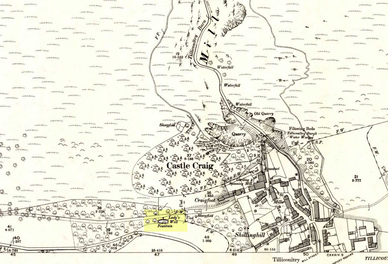
From the main road running through the town, head west towards Alva, and where the golf course begins, take the footpath uphill at its edge which heads towards the giant quarry. Where the dirt-track begins, keep walking along the edge of golf course, noting that where the open field starts, a gate on your right. Go through this, and walk up the side of the fence for some 30 yards, then go through the large gate. 10 yards in front of you, note the small stream crossing the track, and a scatter of overgrown rocks just on the other side of the wire fence. You’re here!
Archaeology & History
Thought by Angus Watson (1995) to have been possibly dedicated to ‘Our Lady’: in this context it’s difficult to know whether the dedication was to the christian Virgin, or to the heathen ‘Lady Alva’, whose web of snow and other natural garments clothe the mountains and glens of the Ochils hereby.
The first account of the place seems to be in William Gibson’s Reminiscences (1883) where he told that,
“In the year 1839, a Mr John Henderson built the only woollen mill…the water for the steam engine of which was got from the Ladies Well”,
Ladys Well on 1899 map
which was barely 100 yards to the west. It was later highlighted on the OS-map in 1899 with an associated ‘fountain’, right by the track-side. A water-pumping station shown at the same time on another map was, of course, the one that was built to supply the mill with water.
The present water source is slightly higher in the field than when it was shown on the early OS-maps, and it does still flow continuously—although the source is much neglected and could do with being recovered: as the photo here shows, an ugly pipe appears to be taking much of the healing waters which are now mainly feeding a large pond in the garden just below.
References:
Gibson, William, Reminiscences of Dollar and Tillicoultry, Andrew Elliot: Edinburgh 1883.
From Thackley corner, take the Esholt road down Ainsbury Avenue. Walk past the Thackley football ground and another 50 yards on, to your left, there’s a field. Cross this and go through the gate into the trees. Another field is across the footpath, but turn right and walk on the muddy path, keeping parallel with the other field, until the walling bends round to the left. About 15 yards round where the wall bends left, watch out for the silver birch tree and the small cup-marked rock at its base, right up against the wall.
Archaeology & History
This is an archetypal single cup-marked stone known as a ‘portable’ — though in its original state, when the rock was obviously larger than it is today, I doubt anyone could have carried it further than a couple of yards! The stone has been split from a larger rock, and we’re unsure the size of its original form—but presume it to have been perhaps double its present size.
The broken rock stands (now) upright against the wall and nice birch tree (Betula pendula), but wasn’t like that when we first found it, and the cup was barely visible as it faced down into the Earth. As the images show, we have just a single cup-mark on its outer face. It looks typical of those carvings found in the larger Bronze Age cairns scattering the moors to the north, but we have no evidence nor folklore indicating the existence of such a monument hereby. The extensive amount of overgrown multiperiod walling all over this woodland may have used up such a cairn, but we will probably never find out, as the woods have been overused by industrialists, who are now, slowly, turning the woods here into a park.
From Thackley corner, take the Esholt road down Ainsbury Avenue. After a couple of hundred yards, note the metal gateways into the woods. Go through here, following the main path, until you reach another split in the paths where one of those awful touristy signs tells you where you are. Walk past this (not left or right) into the opening of large oaks and other trees on a flat plain. A path swings round the right side of this, and less than 100 yards along, watch out for some rocks on your right, heading towards the wall and small field. You’re damn close!
Archaeology & History
Close-up of cup-markings
This is one amongst a cluster of at least five cup-marked stones very close to each other in the woods here — and probably the best of the bunch. Also found in conjunction with what seems to be an Iron Age walled enclosure 20 yards away, there are at least eight cup-marks on top of this rock, They occur in two groups: one, on a sloping section of the boulder where three fading cups can be seen; and the other is on the topmost section of the stone, where five larger cups distinctly stand out, and occur in conjunction with what seems to be a long carved line running close to the edge of the rock before it drops sharply to the ground.
This and its associated carvings are found in close proximity to some sort of walled enclosure. It’s difficult ascertaining the age and nature of the enclosure walling, as masses of it are found throughout this section of woodland and it appears to be multiperiod in age and nature: from Iron Age to Victorian by the look of things. Neither this cup-marked stone, nor any of its close associates (the closest of which is the Buck Woods 3 carving, less than 10 yards away), were recorded in the Boughey & Vickerman survey of rock art in West Yorkshire.
Although cited in all modern archaeology texts as a series of four henge monuments, a recent article by J. Lewis & D. Mullin (2011) inform us that these “are not henges but belong to a tradition of enclosure that predates them and had a different function.” We’ll have to wait and see what they mean by that! In the meantime, we’ll have a quick scurry through the historical accounts of these four impressive ‘henges’ as Burl, Piggott and the others call ’em.
Surrounded at all angles by numerous barrows and tumuli, these four great henge monuments were shown on the 1887 Ordnance Survey map as a row of ‘Supposed Ring Forts’, when such ideas were in vogue, running in a line roughly SSW-NNE; the third one up having a couple of ponds within it. A brief early account of them was given by Harry Scarth (1859)—who was describing the series of nine round barrows a few hundred yards to the south—who told them to be “circular banks” each 500 feet across. The first more detailed account was in A.H. Allcroft’s (1908) classic text, where he wrote the following:
“…Close to the Castle of Comfort Inn, where the high road to Bristol crosses the line of the old Roman road running north-westward towards Charterhouse, there lies immediately west of the high road a series of four circles…all of one size, all of one plan, and all as mathematically exact as circles could well be when executed in such a soil and on such a scale. Although they have suffered greatly from the mining operations which have scarred all the Mendips, as well as from the plough — one of the four is almost obliterated — they are still quite easy to make out. The diameter of each is some 550 feet within the area, which is surrounded by a broad low vallum, and that again by a correspondingly broad and shallow ditch. The height of the vallum above the ditch, where best observable, is some 5 feet. There are no determinable entrances. The most southerly of the group is about 250 feet away from the second ; the second about 200 feet away from the third; and a line joining the centres of the first and third passes through the centre of the second also, and points 17° east of north. The fourth circle lies 1,200 feet away from the third, not in a right line with the others, but slightly to the west. Between the third and fourth circles passes the Roman road. Within the third circle is an old pond of some size.
“With every appearance of being all of one date, and that a venerable one, these circles lack every characteristic of military works. Their peculiar disposition, their painstaking regularity, and their identity of size, all suggest that they must, if really old, be of ritual, and perhaps of astronomical character”
Old drawing of the central hengesHenge 1, recently damaged (courtesy Pete Glastonbury)
Allcroft’s ideas of ritual and astronomy were pretty good for the period, as we take it for granted these days that such events occurred at henges — so the existence of four such sites right next to each other, would have made this one helluva place in neolithic and Bronze Age periods. A few years after Allcroft, the henges were described in Mr Burrow’s (1924) excellent illustrated survey, from which the drawing of the two central henges is taken (the two ‘R’s in the background highlight the line of the Roman road which runs past them). Burrow’s didn’t add much more of any note, simply telling:
“…in the fields north and south, are placed earth-work rings, each about 180 yards in diameter, on a line placed slightly north by east. The most northerly of these rings is almost obliterated, but the three on the west of the road from Chew Stoke to Oakhill are quite clearly defined, as my drawing (above) will show. I have been able to include two of these remarkable rings in my picture, the edge of the bank (which was, when I saw it, fringed with yellow gorse), being about 6 feet above the level of the ditch outside. It is generally supposed that these ringed earthworks were connected with some prehistoric ritual, and Hadrian Allcroft thinks were used for primitive astronomical observations or the construction of a primitive calendar.”
Tratman’s plan of Priddy HengesAnother view of Henge 1 (courtesy Pete Glastonbury)
Many years later when archaeologist K.S. Painter (1964) came to describe these henges, he listed them as “stone circles” (what the hell was he on!?), but this error may derive from the finding of several stones that once existed inside the southernmost Henge 1. These were uncovered following excavation work done here by E.K. Tratman (1967) and his colleagues, who explored and numbered the four henges—running from south to north—as follows:
“Circle 1: This is tolerably complete. A portion of the southwest quadrant has been destroyed by mining and there are three modern gaps in the ring. Mining has involved the ditch on the west and south, and to a small extent on the east. There is an irregular extensive hollow west of the centre and this too is a product of mining and contains a number of large stones so derived. The circle is not quite a true one, being flattened slightly on the west. The circle has a diameter from bank top to bank top of 520ft. The single original entrance is NNE of the centre. Stones 1 and 3-7 were removed by the farmer before excavation, but subsequent ploughing immediately after removal did not reveal any change in soil texture or colour. Stone 8 was placed in its present position quite recently. It is not known where it came from. Other stones have recently been placed on top of the bank east of the entrance by the farmer (1964-5). Stone 2 is in a relatively ancient position.
Circle 2: This is a true circle and its diameter and position of its entrance are similar to Circle 1. It has been considerably disturbed by mining. A group of stones (10-14) and stone 9 represent modern collections from the field. None of them is in its original position. There are two modern gaps in the ring.
Circle 3: This is distinctly flattened on the east and west. The N-S diameter is 520ft and the E-W 490ft from bank top to bank top. The northeast quadrant reported by Allcroft as being levelled is still traceable. The circle has been greatly disturbed by mining… The entrance is SSW of the centre, the opposite pole to circle 1 & 2, and has probably been widened, perhaps by miners. The marsh may be an original feature or the product of mining. The two ponds are certainly modern, and so is a small mound, which is probably spoil from the major pond.
Circle 4: This is incomplete. It has a diameter of 560ft, which is considerably larger than any of the others. The OS map shows only the eastern semi-circle remaining. However, the bank and in part the ditch can be traced…If the visible and proved end of the ditch on the SSW was intended to be at the edge of the causeway, then the entrance would have been in the same position as that of Circle 3.”
Very recently, a local land-owner quite deliberately bulldozed a large portion of the southern henge in this complex, destroying much of it. This act of criminal vandalism will hopefully not go unpunished and is, at the present time, going through the courts.
…to be continued…
References:
Allcroft, A. Hadrian, Earthwork of England, MacMillan: London 1908.
Burrow, Edward J., Ancient Earthworks and Camps of Somerset, E.J. Burrow: Cheltenham 1924.
Lewis, J. & Mullin, D., “New Excavations at Priddy Circle 1, Mendip Hills, Somerset,” in Proceedings of the University of Bristol Speleological Society, volume 25, 2011.
Painter, K.S., The Severn Basin, Cory, Adams & Mackay: London 1964.
Scarth, Harry M., “Some Account of the Investigation of Barrows on the Line of the Roman Road Between Old Sarum and the Port at the Mouth of the River Axe,” in The Archaeological Journal, volume 16, 1859.
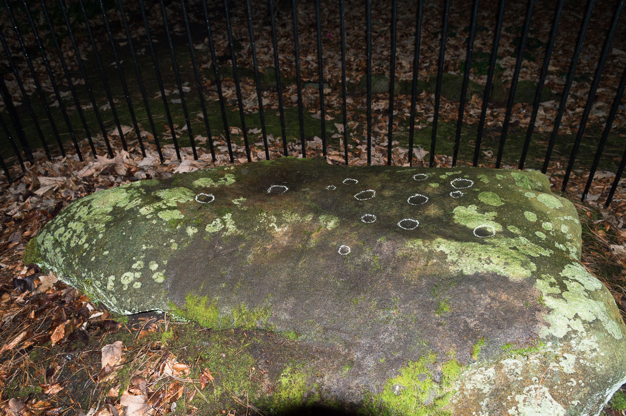
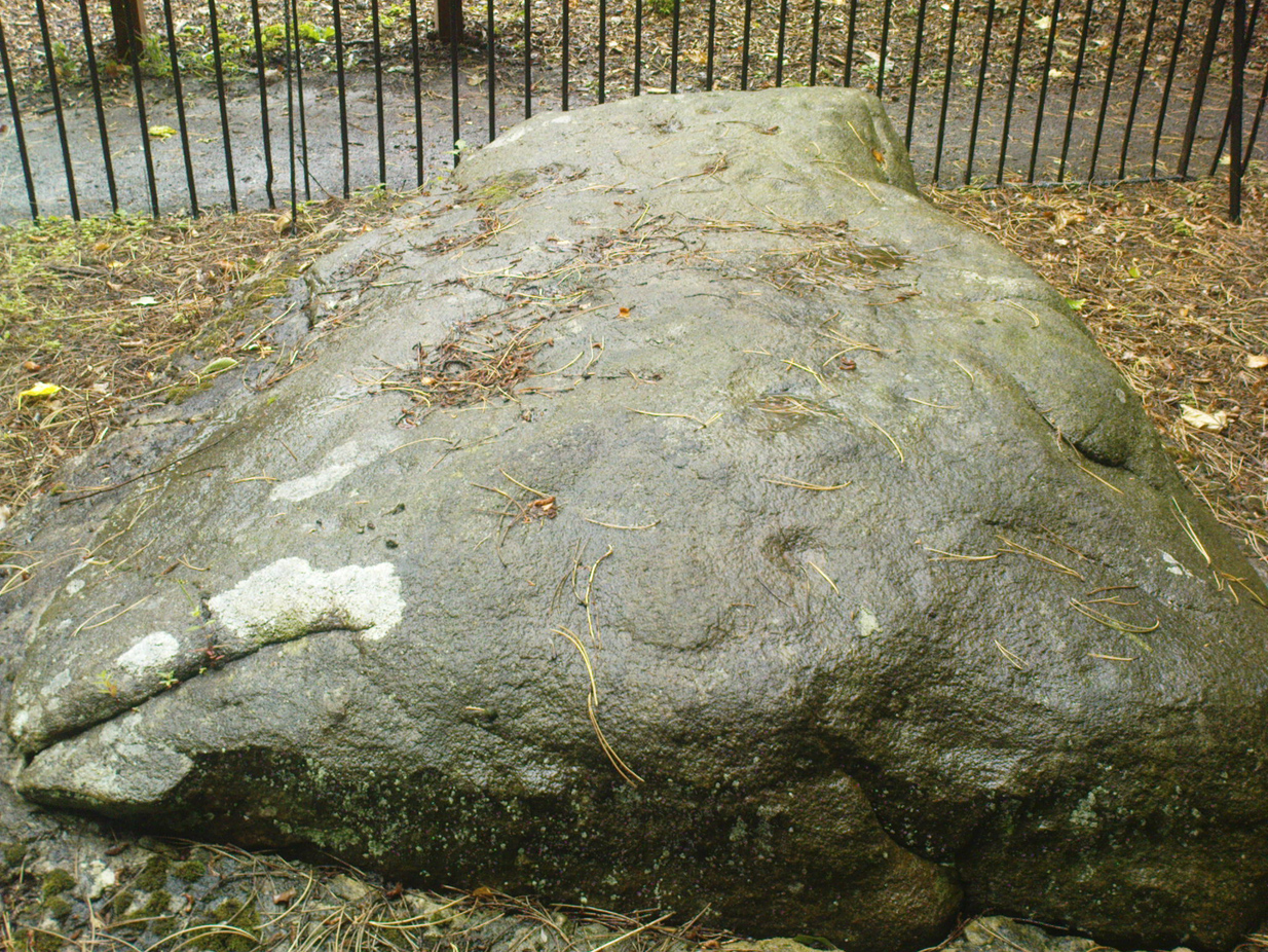
Come out of Ilkley/bus train station and turn right for less than 50 yards, heading left up towards White Wells. Go up here for less than 100 yards, taking your first right and walk 300 yards up Queens Road until you reach the St. Margaret’s church on the left-hand side. On the other side of the road, surrounded by trees is a small enclosed bit with spiky railings with Panorama Stones 227, 228 and 229 all therein: the least-decorated one on the left being the one we’re dealing with here.
Archaeology & History
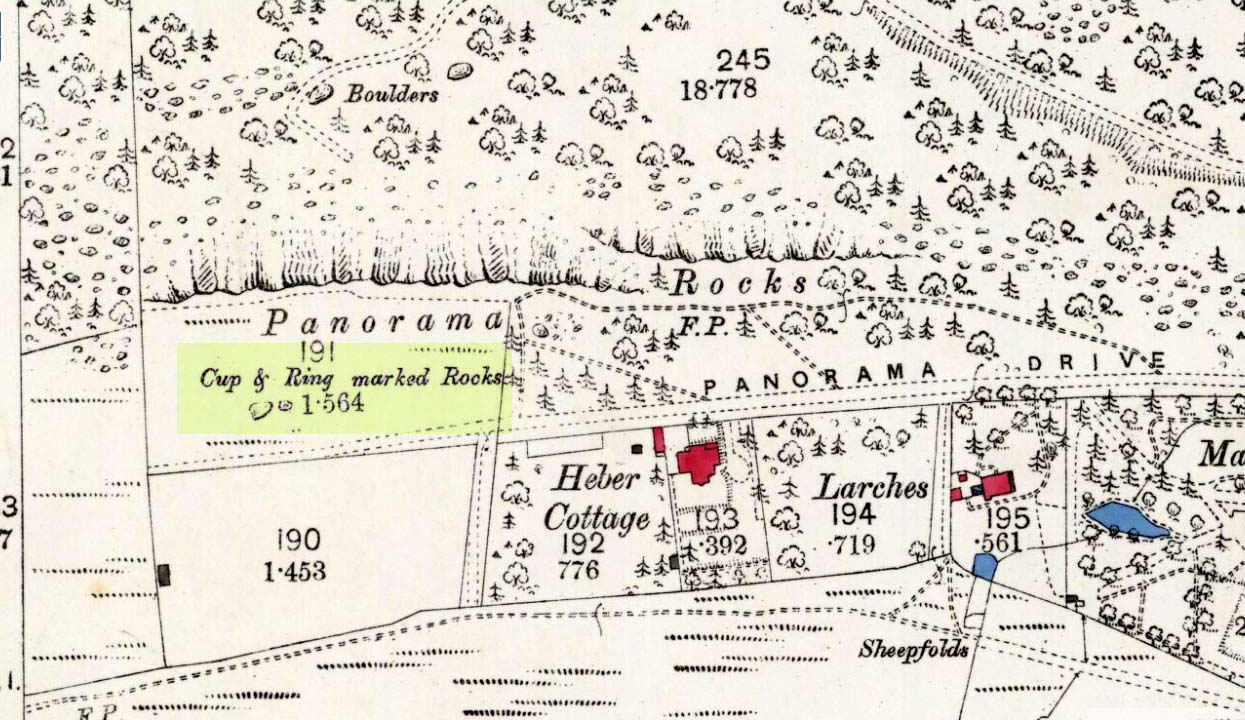
This is another of the caged Panorama Stones, found within the awful spiked fencing across from St. Margaret’s Church, just out of Ilkley centre. Originally located ¾-miles (1.2km) WSW of its present position in Panorama Woods (at SE 10272 46995), along with its petroglyphic compatriots in this cage, the carving was moved here in 1890 when a Dr. Little—medical officer at Ben Rhydding Hydro—bought the stones for £10 from the owner of the land at Panorama Rocks, as the area in which the stones lived was due to be vandalized and destroyed. Thankfully the said Dr Little was thoughtful and as a result of his payment he had some of the stones saved and moved into their present position.
Original location of stonesJ.T Dale’s 1879 sketch
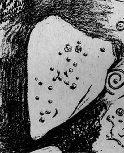
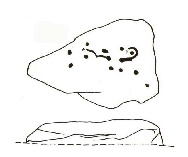
It was first described by the northern antiquarian and petroglyph pioneer, J. Romilly Allen (1879) , who saw it in the now-destroyed “rough inclosure”, as he called it, along with the other stones now in the same Ilkley ‘cage’. Its present position does it no justice whatsoever in terms of its original position. It was ostensibly a rocking stone: this seemingly trivial-looking boulder was sat on top of the much-cropped Panorama Stone 228 (a yard east of the three in this outdoor cage). Allen (1879) was fortunate enough to have seen the stone before it was uprooted, telling us how this topmost stone, “has eleven cups, wo of which are surrounded by single rings.” The modern archaeologist John Hedges (1986) told it to be in a “bad state,” with “very worn carvings, fourteen cups, one with partial ring and groove.” Its situation deteriorated further, as stated by rock art students Boughey & Vickerman (2003), who noted,
“medium-sized, roughly triangular rock, its surface recorded as in a bad state in 1986 and now (2002) even worse. Fourteen cups, one with partial ring, one groove.”
And its condition isn’t helped by its inaccessibility, when groups like the ‘Friends of Ilkley Moor’ or the local archaeologist should be at least annually cleaning this and the adjacent carvings. If they’re incapable, there are sincere people in antiquarian, history and pagan groups who would probably help out…
John Hedges 1986 sketchFaint cupmarks visible
In truth, this carving cannot be seen in isolation, nor merely reduced to a numeric catalogue in some rock art corpus. We must contextualize its relationship with the once much-larger multiple cup-and-ring stone on which it sat and then see it as it was in the landscape. Originally of course the rocking stone was Nature’s very own creation. As humans began migrating over and eventually occupying this once-wooded arena, the rocking stone became intimately related with animistic magickal rites and, over time, petroglyphs began to be etched upon the stone. Most probably the flat underlying rock surface was carved upon first, and a symbiotic relationship was forged between Earth’s surface and the small rocking stone, both of which were used in oracular and other rites. Over centuries, as the cups and rings on the earthfast stone grew, the mythic status of this small rocking stone allowed for the encroachment of carvings, and eventually cup-marks began to be etched upon it too. Later still, as the neolithic period moved into the Bronze Age, the people began to build a low-walled stone enclosure around this and the nearby multiple-ringed carving – similar to the multi-period enclosure at Woofa Bank and other sites on these moors. It was all a very long and gradual process.
In truth, the mythic status of this once-impressive site would have been maintained—in one form or other—well into the medieval period. But that’s another matter altogether…
Bennett, Paul, The Panorama Stones, Ilkley, TNA: Yorkshire 2012.
Bennett, Paul, Aboriginal Rock Carvings of Ilkley and District, forthcoming.
Boughey, Keith & Vickerman, E.A., Prehistoric Rock Art of the West Riding, WYAS: Leeds 2003.
Cowling, Eric T., Rombald’s Way, William Walker: Otley 1946.
Downer, A.C., “Yorkshire Archaeological and Topographical Association,” in Leeds Mercury, August 28, 1884.
Eliade, Mircea, The Sacred and the Profane: The Nature of Religion, Harcourt, Brace & World: New York 1959.
Hadingham, Evan, Ancient Carvings in Britain, Souvenir Press: London 1974.
Hedges, John, The Carved Rocks on Rombald’s Moor, WYMCC: Wakefield 1986.
Heywood, Nathan, “The Cup and Ring Stones of the Panorama Rocks”, in Transactions Lancashire & Cheshire Antiquarian Society, Manchester 1889.
Speight, Harry, Upper Wharfedale, Elliott Stock: London 1900.
Acknowledgements: With huge thanks to both Dr Stefan Maeder for help in cleaning up the stones; and to James Elkington for allowing use of his photos in this site profile.


002")
")
")

")
")

")