Various ways here. From Keighley, go up the A629 Halifax Road, first left after the Ingrow West train station, uphill; then turn right, and up the long, cobbled, zizaggy road past the little hamlet of Hainworth and uphill till you reach the solitary farmhouse of Goff Well Farm (where its friendly owners can sell you organic fresh eggs!). It’s the field just before here on your left (if you reach the Guide Inn pub further uphill by the crossroads, you’ve gone too far). Alternatively start at the Guide Inn pub and walk across the road and downhill till you reach the farm. It’s in the first field on the right just past it.
Archaeology & History
Little is known about the history of this water source. The first description of it seems to be in 1852. Harry Speight (1898) mentions it briefly when he talks about the holy wells of the locale, saying simply:
“Goff Well, close to the road on Harden Moor leading to Hainworth, has given name to a neighbouring farm, but the purpose or virtues of this water are not now known.”
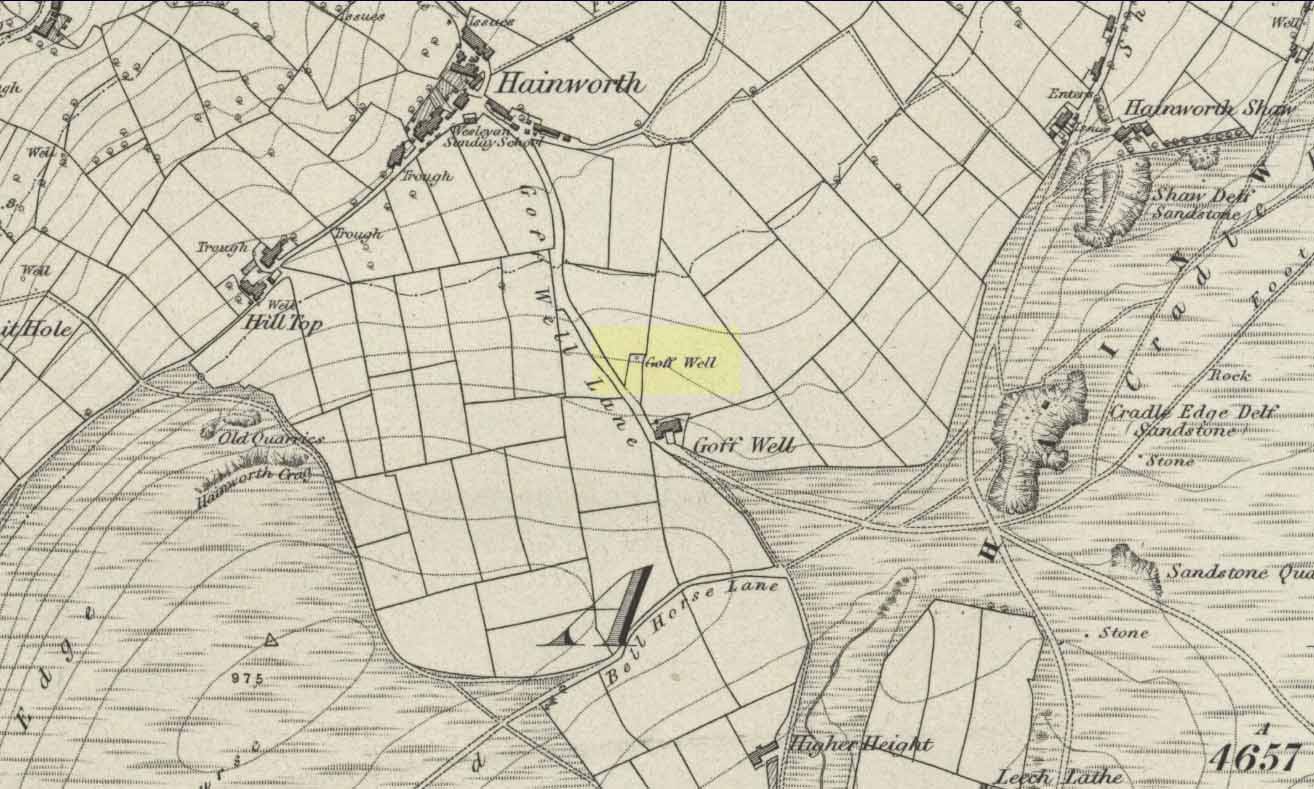
Goff Well on 1852 OS-map
Today the well is much overgrown and in need of attention. It’s near the bottom corner of the field where the larger of the elder tree grows (the witch’s tree par excellence) and could do with being cleaned out. When the owner of Goff Well Farm, Barry, took us to see the site, the waters couldn’t be seen but we could hear the water running clearly just beneath the surface, so it just needs a few hours work to bring it back into life. Twouldst do the land and the genius loci the world of good!
The very name of the well is something of an anomaly. There are several possibilities and we (as yet) cannot say which is the more likely derivation. We know in northern dialect that Goff is a simpleton or fool, and although we can apply that definition in some cases, it’s unlikely to apply here. If we could ascertain there was ever an apple tree growing here, the mystery would be solved, as a goff was an old word used for the common apple. In West Yorkshire dialect the word was also used to denote “a hammer worked by water-power”; aswell as it being a corrupted form of the word ‘God.’ Take your pick!
Folklore
The early Victorian historian William Keighley (1858) thought Goff Well was named after a long-forgotten hermit called Goff who, at some time in the past, gave his name to the old hamlet of Hermit Hole, a half-mile downhill from this water source. Mr Keighley wrote:
“On the skirts of Harden Moor is a farmhouse known by the name of Goff Well; and as goff is said to be the Danish word for red, it would probably be no great stretch of the imagination to suppose that the hermit was so named on account of his red hair, and the spring or well designated after him from the frequency and sanctimonious nature of his visits.”
But this is pure supposition on Keighley’s part — nice idea though it is! The only tangible piece of folklore we have is that the well “was a famous resort of gypsies before the moor was enclosed in 1861.” (Speight 1898)
References:
Keighley, William, Keighley, Past and Present, Arthur Hall: London 1858.
Speight, Harry, Chronicles and Stories of Old Bingley, Elliott Stock: London 1898.
Thor Stone, Taston, hiding in shadows on bright sunny day
Very easy! From which ever direction you approach the gorgeous little village of Taston, get to the Cross in the middle of the road and look up the slight hill and at the old walling on the right-hand side. You can’t really miss it!
Archaeology & History
An impressive seven-foot tall standing stone resting up against the walling of Martin and Martha’s Thorstone Cottage, and which appears to have been recorded as far back as the late thirteenth century in the survey of the Chadlington hundred. Indeed, according to the respective place-name authorities, the village of Taston itself appears to get its name from the Thor Stone, as it’s recorded as Thorstan in 1278 CE. (Gelling 1954)
Less than 100 yards away is a large old stone cross, the top of it now fallen, which may once have had some earlier pre-christian relationship with the Thor Stone; perhaps originating from other standing stones close by our now solitary Thor Stone (see Folklore, below). No other monoliths or prehistoric tombs are presently associated with this site, but its folklore tells of earlier companions…
More than a hundred miles north of here we find an etymological sister in the old village of Thurstaston and where, not surprisingly, we have another Thor’s Stone — but in this instance the name applies to a huge rock outcrop with old pagan legends attached.
Folklore
Elsie Corbett (1962) tells that the creation myth for this stone was that it originated after the great god Thor cast a thunderbolt down from the heavens and this stone appeared as a result. But more intriguing from an archaeological perspective is what Mike Howard (he of The Cauldron magazine) told us in a short article for the Gloucester Earth Mysteries magazine in 1994, which said that our grand old Thor Stone was once part of a stone circle. He wrote:
“At Taston…are the rather battered remains of a megalithic circle known locally as the Thor Stones. It seems the original circle was dug up many years ago and the stones now reside in a neat pile at the crossroads in the centre of the village. The whole edifice resembles nothing less than an eccentric market cross, topped by a phallic stone.”
Although he doesn’t cite any sources for this bit of info (where’d you gerrit from Mike?), we need to take a more careful look at the old cross nearby. And we find another piece of folklore relating to the Taston cross which said that it was placed there to abate the evil influences that were supposed to come from the Thor Stone. This piece of folklore is simply one laid down by the Church which portrayed most things it did not understand, or sought to repress, as being the work of their own demonic power, Satan.
Between these two old monuments was once a huge old elm tree which, says Caroline Pumphrey (1990), was a meeting place of the local villagers in times gone by. Whether this implies the Thor Stone to have been a moot spot is difficult to tell, although the erection of the cross would seem to add weight to this.
More recent screwy notions comes from one woman who reckoned, curiously, that the Thorstone got its name from some completely invented made-up goddess, saying:
“I believe its more likely to be a corruption of the name of ‘Hoar’, the great Goddess. Indeed the Hawk Stone, and various Hoar stones stand widely hereabouts and probably derived their names from the same deity.”
Utter drivel of course (there’s no such goddess as Hoar)! But — like the christians and others before them — people believe what they want to believe and this sorta nonsense is increasingly found all over the internet. As is well known, the word hoar derives from ‘har’, being ‘grey’ or ‘a boundary’ (Gelling, 1954; Smith 1956); and numerous studies show this quite clearly.
References:
Bennett, Paul & Wilson, Tom, The Old Stones of Rollright and District, Cockley: London 1999.
Corbett, Elsie, A History of Spelsbury, Cheney & Sons: Banbury 1962.
Gelling, Margaret, The Place-Names of Oxfordshire – volume 2, Cambridge University Press 1954.
Grigson, Geoffrey, The Shell Country Book, George Rainbird: London 1962.
Howard, Mike, ‘From Thor to Rollright,’ in Gloucestershire Earth Mysteries 18, 1994.
Pumphrey, Caroline, Charlbury of our Childhood, Sessions Book: York 1984.
Smith, A.H., English Place-Name Elements – volume 1, Cambridge University Press 1956.
From the old Glen House pub, walk up the road onto ‘Shipley Glen’ as all locals call the place. Go up the Glen Road for about half a mile, watching out for the small dirt-track turning going the slope on your left-hand side just near where the road starting swerving uphill to the right. At this point where the track heads down and into the trees, there’s a footpath going into the bracken along to the right, heading onto level ground. Walk up and along here. After 100 yards or so you’ll notice the disused quarry on your left. Keep walking along the footpath (two end up running parallel to each other) and you’ll see this carving right beneath your feet!
Archaeology & History
Baildon Moor carving 126
This was one of the very first examples of “cup and ring stones” that I ever saw, when I was a mere 10 or 11 years old! I’m not quite sure what I expected to find, but something about this stone with its deeply set cup-markings obviously had an effect on me – as I’m still foraging about looking at them more than 35 years later! About 20 yards away from the Glovershaw quarry carving (Baildon Moor 122), this central design stone — as I used to call it — was first recorded in W. Paley Baildon’s (1913) magnum opus and was then all-but-forgotten until the Bradford Archaeology Group mentioned it again more than forty years later. Although you can only see three distinct cups on this small rock, another 2 or 3 seem in evidence under better lighting conditions, and a small line runs below the cups in the photo here, which you can just make out above the central cup.
This carving and others close by give the distinct impression that they were once part of some seemingly lost cairn-field, awaiting rediscovery…
References:
Baildon, W. Paley, Baildon and the Baildons – parts 1-15, Adelphi: London 1913-1926.
Bennett, Paul, Of Cups and Rings and Things, unpublished: Shipley 1981.
Bennett, Paul, Megalithic Ramblings between Ilkley and Baildon, unpublished: Shipley 1982.
Boughey, Keith & Vickerman, E.A., Prehistoric Rock Art of the West Riding, WYAS: Leeds 2003.
Cowling, Eric T., Rombald’s Way, William Walker: Otley 1946.
Hedges, John, The Carved Rocks on Rombald’s Moor, WYMCC: Wakefield 1986.
Various ways here. From Keighley, go up the Halifax Road, first left after the Ingrow West train station, uphill, then up the long zizaggy road till you hit the pub at the crossroads. Park up and walk along the road in front of the pub for 1-200 yards and look at the hill above you! Alternatively, from Bingley go up to Harden on the B6429 and literally just where the village ends, there’s a small right-turn (if you’re going past the fields on either side, you’ve just missed the turning!). Go up there till the road reaches the top and stop! Catstones Hill is in the heather over the wall on your left!
Archaeology & History
A somewhat anomalous earthwork site, with lots of archaeohistorical speculation behind it, but no firm conclusion as to its precise nature as yet. Defined variously as an earthwork, an enclosure (for both people and cattle!) and a settlement by respective archaeologists over the years, there is little to be seen of the place on the ground and it doesn’t tend to bring raptures of delight to the common antiquarian. When William Keighley (1858) described this place, Catstones Ring was,
“enclosed on three sides by a considerable bank of earth, and bears evident marks of the plough. The country people believe it to have been an intrenchment or camp.”
Mrs Ella Armitage (1905) thought this site may have been “a prehistoric fort,” but said little more about it. In the same year however, Mr Butler Wood (1905) gave us a much better account of the place, describing Catstones Ring as “the most striking earthwork in the neighbourhood of Bradford.” His broader description told that:
“It encloses the crest and slope of a hill, and measures 266 yards on the east side (which is perfect), and 100 yards on the north side; the latter, however, being traceable at least 100 yards further across cultivated fields. The south side is almost obliterated by quarries, while the western portion has disappeared altogether. The fosse which surrounded this fine fortification is still visible on the eastern side.”
A couple of years later two short notes were made of the site in Forshaw’s Yorkshire Notes and Queries. Peter Craik (1907) of Keighley described the dimensions of the main ring as being “110 x 320 yards (rough guess),” and he also described finding the remains of a cairn in the outer dyke section (marked as ‘X’ on Craik’s diagram, below). On the nature of the site, he wrote:
“Catstones would appear to have been built as a defence against invasion from the south, for in contrast to the early defensible approach from that direction is the fact that to the north lies the undulating expanse of Harden Moor, which for the most part is on a level with the ring, even the highest point in the immediate vicinity being without the main circle, though enclosed in a minor outwork. The large extent of the ring makes it rather difficult to believe that enough men could be collected in the immediate neighbourhood to man the lines satisfactorily; and again as a shelter for cattle, etc, in time of war it does not appear to be well designed, for most of the interior would be commanded within easy range of arrows. Certain old excavations exist within the ring; probably they were made in search of gravel or some such material, but is this conjecture certain? Can they possibly mark the site of dwellings?”
J.J. Brigg (1907) followed up Craik’s short piece with the suggestion that the site was Roman in origin, saying:
“In showing the 6in map to Professor Bosanquet of Liverpool…he said there was no reason why it should not be Roman, merely because there is no masonry. The Roman legions went into laager* every night, and it is quite possible that some very large body of soldiers halting there for the night might have thrown up an earthwork and planted thereon the stakes which they always carried with them for that purpose.”
But I think this is most unlikely. Very little has been found here to give us a better idea of dates and function; and in a limited excavation here in 1962, no artifacts of any kind were located. A little more recently, J.J. Keighley (1981) has suggested the site to be Iron Age in date, describing it as one of the most impressive sites of its kind in the region. The Catstones Ring is “a 6.5 hectare quadrangular ditched enclosure,” he wrote, which he thought had been much destroyed by the adjacent quarrying.
“Aerial photographs taken by the County Archaeology Unit in 1977 however, shows that the southeastern corner of the enclosure and parts of its southern ditch survived the quarrying. Villy (1921) observed an outwork to the north of the main enclosure, which was visible on aerial photographs taken in 1948, and the 1977 aerial photographs…show a possible annexe attached to the outside of the northeastern corner of the main enclosure.”
P. Craik’s 1907 drawing
This extended section of Catstones’ main earthworks were, in fact, first described in the article by Peter Craik (1907), as shown in the hand-drawn plan of the site here. And in all honesty, virtually nowt’s been done since these early antiquarians diggings and essays. The information from the present day Sites and Monuments Record says that the site is a “late prehistoric enclosed settlement” and that quarrying has destroyed much of the west side.
Folklore
Harry Speight (1892) reported the earthworks here to have been a site where a great battle once took place, between the local people and the early Scottish tribes.
References:
Armitage, E., ‘The Non-Sepulchral Earthworks of Yorkshire,’ in Bradford Antiquary, New Series 2, 1905.
Go up from Oban on the A85, past Connel and towards Taynuilt, keeping your eye out for where the train-line crosses the road. Just before this is a small road on your left leading down to the sea, with the train line running parallel all the way down. Go right to the end and then look up to the rocky rise a coupla hundred yards on where the train line runs out of view round the coastal edge. That’s it!
Archaeology & History
When Scottish writer and historian R. Angus Smith (1885) first saw this, the close arrangement and size of the stones that make up the edges of this dun made him think this was actually a stone circle up here. Sadly it wasn’t to be. Following an examination of the site in 1969 by members of the Scottish Royal Commission (Argyll – Volume 2, 1975), they described Dun Chathach as,
“circular in plan…measuring 18.3 metres in diameter externally. The wall, which has been about 3.4 metres in average thickness, is now reduced to a low grass-grown stony bank, but considerable stretches of the outer face are still visible in situ. Many of the facing stones, which lie as much as 1.6 metres below the level of the summit, are of massive proportions, the largest measuring 1.4 metres by 1.3 metres and 1 metre high. It is uncertain which of the three gaps now visible in the wall indicates the site of the original entrance.”
Folklore
Legend has it that this was a hill of battles. It was also said by R. Angus Smith (1885) to “have been used as one of a chain of beacons,” with the next fire on being lit upon a small hill nearer Connel called Tom na h-aire, ‘the mound of watching.’
References:
Royal Commission on the Ancient & Historical Monuments, Scotland, Argyll- volume 2, HMSO: 1974.
Smith, R. Angus, Loch Etive and the Sons of Uisnach, Alexander Gardner: London & Paisley 1885.
Cup-and-Ring Stone (destroyed): OS Grid Reference – NT 138 746
Archaeology & History
Lost carving of Carlowrie
Two-thirds of a mile west of the Cat Stane, on land immediately north of the River Almond by Edinburgh Airport in an area that was reported in 1780 to be “filled with the skeletons of human bodies,” this old petroglyph could once be found. The Scottish Royal Commission (1929) described it as being a covering stone for a short prehistoric tomb near the OS-grid reference cited here, “but when discovered it was much broken by the plough that it does not appear to have been preserved.” They refer instead to the last report of the site in the Scottish Society of Antiquaries journal, where we were informed that the cover stone was,
“marked with three series at least of concentric circles… The widest diameters of the sets of rings cut on the inside of the lid is about five inches, and each set is composed of five concentric circles.”
All trace of this carving appears to have been lost. Other carvings reported nearby in the 19th century also appear to have been lost or destroyed.
References:
Morris, Ronald W.B., The Prehistoric Rock Art of Southern Scotland, BAR 86: Oxford 1981.
Royal Commission on Ancient & Historical Monuments, Scotland, Midlothian and Westlothian, HMSO: Edinburgh 1929.
Simpson, J.Y., The Cat-Stane, Edinburghshire, Neill & Co: Edinburgh 1862.
Simpson, J.Y., “On Ancient Sculpturings of Cups and Concentric Rings,” in Proceedings of the Society of Antiquaries, Scotland, volume 6, 1864-66.
James Fergusson’s drawing of both cursus monuments
Just like its much larger companion, the Stonehenge Cursus earthwork a short distance to the south, this Lesser or Small Cursus is generally deemed by archaeologists to “speak of a clear religious or ritual aspect to this patch of downland that…reaches back generations before the first Stonehenge was built.” (Pitts 2001) The monument was aligned roughly east-west, showing possible relationships with the rising and setting of both sun and moon. (though I wouldn’t get too carried away with that misself…)
When Fergusson (1872) described this and its larger cursus companion a few hundred yards away, he thought they may have been dug to mark out lines of battle in prehistoric times, denouncing the horse-racing course hypothesis that was still in vogue at the time. His theory drew evidence from the numerous prehistoric tombs scattering this area of Salisbury Plain, but seemed more influenced by notions of prehistoric barbarism and warfare than ideas relating to a cult of the dead — which was yet to reach it heights in the archaeological minds of Victorian England. But, like other cursus monuments all over the British Isles, this one also seemed to have a distinct relationship with monuments of the dead: for at its western extremity (until being ploughed out of existence) was a large round barrow, catalogued as the “Winterbourne 35” tomb. Tim Darvill (2006) tells its wider tale:
“Levelled by ploughing between 1934 and 1954, the Lesser Cursus was investigated in 1983 as part of the Stonehenge Environs Project… Three trenches were cut into different parts of this large monument, showing that there were at least two main phases to its construction. Phase 1 comprised a slightly trapezoidal enclosure 200m by 60m, whose ditch may have been recut more than once and in part at least deliberately back-filled. In Phase 2 this early enclosure was remodelled by elongating the whole structure eastwards by another 200m. This extension comprised only two parallel side ditches, making the whole thing about 400m long with a rectilinear enclosure at the west end with entrances in its northeast and southeast corners giving access into a second rectilinear space, in this case open to the east.”
Lesser Cursus aerial viewGround-plan of the Lesser Cursus (after Richards 1990)
The entire structure had finds dating from the periods between 3650-2900 BC; and the aerial imagery showing an oval-shaped structure near the eastern end was confirmed by geophysical surveys — though precisely what this is has yet to be ascertained.
It seems likely that this and other cursus monuments were, to a very great degree, not only related to mortuary practices but — as their development occurred at the same time as the destruction of Britain’s great forests began — to be monuments to the gods themselves. This seems very evident at a couple of cursus monuments where animal deposits were made in some of the great mounds at their terminii, where archaeologists had previously assumed— incorrectly — the mounds to have been human burial mounds. More about this in due course…
References:
Darvill, Tim, Stonehenge: The Biography of a Landscape, Tempus: Stroud 2006.
Devereux, Paul, The Haunted Land, Piatkus: London 2001.
Fergusson, James, Rude Stone Monuments in all Countries, John Murray: London 1872.
Loveday, Roy, Inscribed Across the Landscape, Tempus: Stroud 2006.
North, John, Stonehenge, Harper-Collins: London 1997.
Pitts, Mike, Hengeworld, Arrow: London 2001.
Richards, Julian, The Stonehenge Environs Project, English Heritage: London 1990.
Standing Stone (destroyed): OS Grid Reference – NG 520 144
Folklore
This once-famous standing stone appears to have gone. It was described in Otta Swire’s (1961:230) superb book on the folklore of Skye, where she wrote:
“Overlooking Elgol is Bidein an Fhithich. Near here once stood the famous Raven’s Stone, about which the Brahn Seer prophesied. It is believed that this prophecy, however, can never be fulfilled, as seventy or eighty years ago the stone was broken up and the main portion of it is now incorporated in one wall of the Glendale church, according to the Rev. A. R. Forbes’ Place Names of Skye. The stone was believed to have had some connexion with old pagan religious ceremonies.”
The Brahn Seer (more commonly known as the Brahan Seer) was Coinneach Odhar, a 16th century prophet who is said to have foretold the Battle of Culloden and other events.
References:
Swire, Otta F., Skye: The Island and its Legends, Blackie & Sons: Glasgow 1961.
Stone Circle (destroyed): OS Grid Reference – NG 552 172
Also Known as:
Cille Mhaire
Folklore
Omitted from Burl’s (2000) magnum opus, the great Scottish folklorists Otta Swire (1961) is the singular reference to the forgotten stone circle that once existed here. She wrote:
“The site of the old church of Kilmarie and of the stone circle whose proximity no doubt originally called it into being are now no longer to be seen. The ruins of the old church, I am told, were swept away by the sea during that great storm in the 1920s which also blew down the Dunvegan woods. The storm followed not long after the burial near the old church of an unknown sailor taken from the sea, and there were those who believed this to be the cause of the church’s disappearance, for, as the old Gaelic rhyme says: “The sea will search the four russet divisions of the universe to find her children,” and Kenneth MacLeod advises that a body taken from the sea should always be buried near the water’s edge, or the sea, desiring to recover her own, will flood much land in search of it.
“This church is said to have stood on the site of an older church of St. Maelrhuba (Servant of Peace) who was the patron saint of south-eastern Skye.”
References:
Burl, Aubrey, The Stone Circles of Britain, Ireland and Brittany, Yale University Press 2000.
Swire, Otta F., Skye: The Island and its Legends, Blackie & Son: Glasgow 1961.
Standing Stone (destroyed?): OS Grid Reference – NS 805 958
Archaeology & History
Nearly a hundred years ago Christina Buchan told the local writer Donald Morris (1935) about this seemingly forgotten and lost megalithic site. The narrative she gave told:
“I remember a stone which was known among the Causewayhead people as the Bel Stane. (The name is significant) It originally stood in the Doocot Park on Spittal Farm. This park overlooks the high road from Causewayhead to Bridge of Allan and adjoins the steading of Spittal… When the road leading up through the village of Causewayhead was formed (about 1820), the garden of William Robb’s cottage near the foot of the Broad Loan was somewhat altered in shape. He put up a new gate and, requiring a gatepost, he lifted the Bel Stane from Doocot Park and set it up at the front of his own house to support the gate. It was a stone of pillar-shape and stood four or five feet above the ground, and I do not remember whether they were any markings on it. The cottage became ruinous many years ago and the garden ran waste. A new house is now built on the site, but the Bel Stane has been lost.”
There is a possible contender for the lost Bel Stane, used again as another gatepost, on the south-side of the road some 450 yards to the east (at NS 80922 95931). The stone in question is somewhat fatter than usual gateposts, about four-feet tall, and has the eroded appearance of considerably greater age than many others. The monolith isn’t mentioned in the Royal Commission’s Stirlingshire inventory. Further information would be very welcome.
References:
Morris, David, B., ‘Causewayhead a Hundred Years Ago’, in Transactions of the Stirling Natural History and Archaeological Society, 1935.


")


")

")