Stone Circle (destroyed): OS Grid Reference – NY 549 182
Archaeology & History
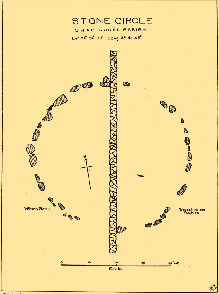
This site has been completely destroyed by the huge eyesore of a quarry that we all see when we’re travelling up the M6 north, above Shap. John Waterhouse (1985) told that “a rescue excavation” was carried out here with help from the kids at Penrith Queen Elizabeth School, shortly before its destruction in 1952, but now there is no trace left of it. When it was first described by J.E. Spence (1935), the circle had already been damaged by a wall that cut right through its centre. He told:
Spence’s 1935 plan
“The circle, which is 6o feet in diameter, is composed of 35 stones, 20 being on the west and 15 on the east side of the boundary wall running through the circle from north to south. The stones of which the circle is composed are Borrowdale erratics, a large number of which are scattered over the adjoining ground on both sides of the wall but more thickly in Sweet Holme Pasture. The stones, which vary up to 5 feet 9 inches by 3 feet, are larger and more numerous in the north-west quadrant where the tallest stands 1 foot 8 inches above the level of the turf. The ground within the circle is level, but to the south and west it slopes gently down from the edge of the circle in such a manner as to suggest that the area within the circle has been levelled.”
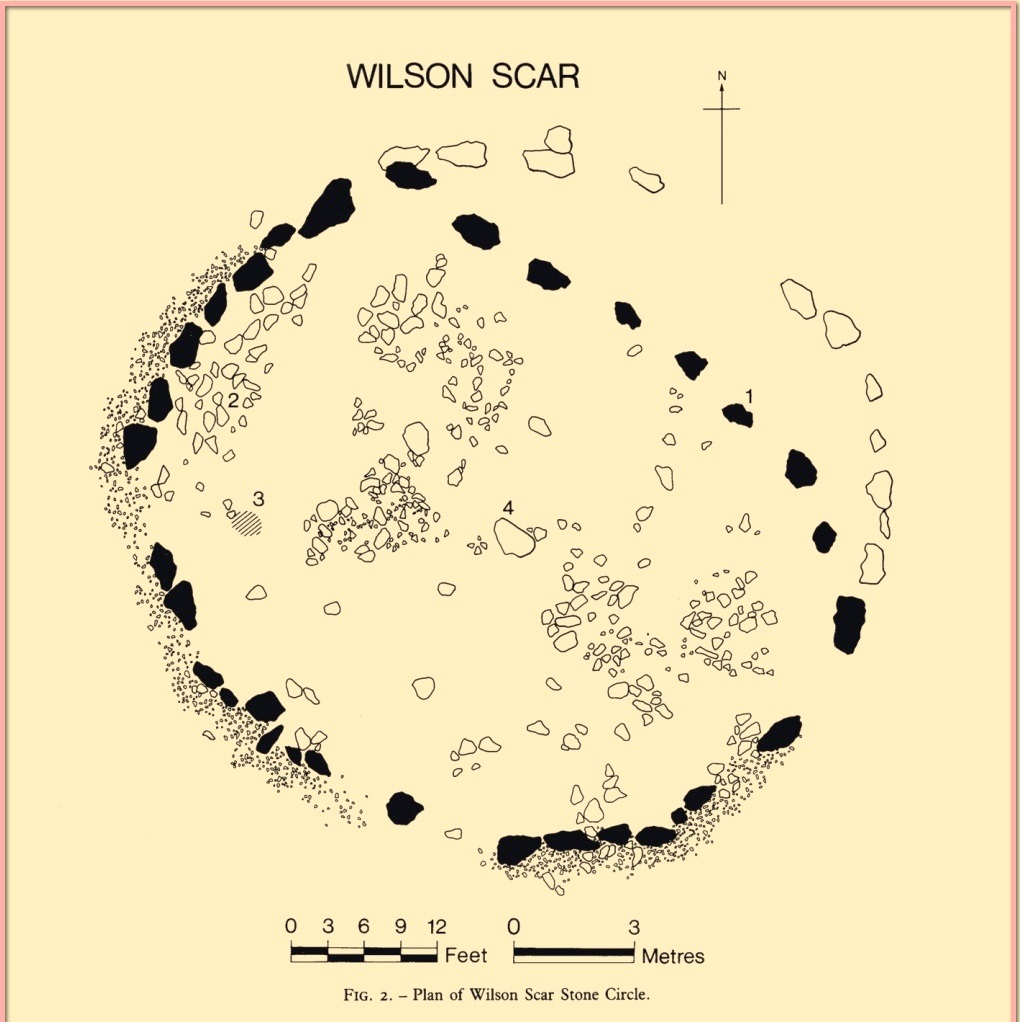
1952 plan laid over Spence’s 1935 plan
Spence told that an ancient “sunken trackway” led outwards from the circle to the south-west in the direction of Rosgill, but when the 1952 excavation occurred, no remains of such a track were found; nor was the wall that had cut through it; and the north-easterly section of the circle had been cut into and re-laid, presumably by the quarrymen. It was quite plain, wrote G.G. Sieveking (1984), “that this portion of the monument was encroached upon in the summer of 1952, and hastily reconstructed for the benefit of the archaeologists.”
Their excavation found that some internal sections of this ring had been paved with thin limestone slabs and they also uncovered two small cairns, neither of which possessed anything. However, they did find four funerary deposits within the monument: one at the northeastern section of the circle (no.1); another near the centre (no.4); and remains of a cremation west of centre (no.3); but the most complete find was at the western side of the ring, where a “disarticulated inhumation burial was lying immediately beneath the turf line in a shallow grave 1.35 m long, surrounded by a setting of small boulders.” It was a near complete human skeleton. This place was obviously, at times, used in ceremonies for the dead.
Shortly after the archaeological examination of the site, it was blasted away by quarrying. Gone!
References:
Barnatt, John, Stone Circles of Britain– volume 2, BAR: Oxford 1989.
Burl, Aubrey, The Stone Circles of Britain, Ireland and Brittany, Yale University Press 2000.
Farrah, Robert W.E., A Guide to the Stone Circles of Cumbria, Hayloft: Kirkby Stephen 2008.
Seton, Ray, The Reason for the Stone Circles in Cumbria, privately published: Morecambe 1995
Sieveking, G.G., “Excavation of a Stone Circle at Wilson Scar, Shap North 1952,” in Transactions Cumberland & Westmorland Antiquarian & Archaeological Society, volume 84, 1984.
Spence, J.E., “A Stone Circle in Shap Rural Parish,” in Transactions Cumberland & Westmorland Antiquarian & Archaeological Society, volume 35, 1935.
Waterhouse, John, The Stone Circles of Cumbria, Phillimore: Chichester 1985.
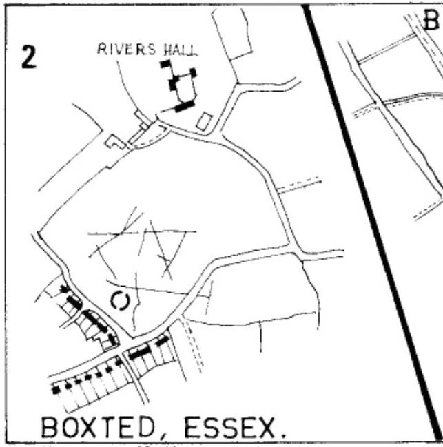
As with many sites in Southern England, intensive agriculture has taken its toll on the archaic monuments. The Boxted Cross henge is no exception and hardly any elements of it remains today. But it seems that it was an impressive fella in our more ancient heathen past.
The site was only rediscovered in the 1970s and was first described in Mrs Ida McMaster’s (1975) survey of crop-marks that had been revealed by aerial surveying in Essex and Suffolk counties. Her brief account of the monument told it to be,
“A Class II henge with a wide somewhat ploughed out ditch. Various linear ditches are near, together with prolific variegated ‘field outlines’ of glacial subsoil cracking which extends into the next field southwards. The ditch terminals of the southwest entrance to the henge appear to be wider than the general run of the ditch, say 4-5 metres.”
When Harding & Lee (1987) examined the site, they were a little more cautious in their interpretation of it being a definite henge, citing that there was “insufficient information, but cannot be ruled out as henge-related,” adding that it “could also be a mill.” This latter element seems unlikely, though a windmill may have been built onto the site at a later date.
More recently however the site has been categorized by Historic England as “a Late Neolithic henge.” The monument itself was defined by a broad circular ditch with two large opposing entrances to the north and south. The total diameter of the enclosure is 44 yards (40m) across; but with the surrounding ditch measuring 5½ yards (5m) across all around, the inner level of the henge was about 33 yards (30m) in diameter. Plenty of room for partying old-style!
References:
Harding, A.F. & Lee, G.E., Henge Monuments and Related Sites of Great Britain, BAR 175: Oxford 1987.
Any remains of this once sacred site are now beneath the airport between Benson and Ewelme, a couple of miles northeast of Wallingford, on the eastern side of the River Thames. A great pity. It was one of the early cursus monuments discovered as a result of Major G.W. Allen’s many aerial surveys in southern England — as shown in his photo here — and subsequently described in Mr Leeds’ (1934) Antiquaries Journal article. A cluster of cursus monuments were built in this part of England in neolithic times, and Roy Loveday (2006) includes the Benson Cursus as an ingredient within the ‘sacred landscape’ region of what he calls “the Dorchester-on-Thames complex.” The Benson Cursus and surrounding regional monuments,
“in fact possesses features that would declare it as an inter-regional sanctuary if encountered in an historical setting; namely, intensity of monument construction, longevity of respect, addition of later exotic monuments with far-flung parallels, large numbers of burials, and placement in a landscape structured, partly at least, by other monuments. These elements recur from Delphi to Uppsala, and from Pachacarmaca to Mecca, at sites that Mircea Eliade (sic) has termed hierophanies — locations where the otherworld of gods and ancestors communicate with the living.”
Loveday’s 2006 planBenson Cursus plan (after Barclay & Lambrick)
It’s good to know that the correct paradigms are at last emerging from those archaeocentric minds!
In Mr Loveday’s (2006) plan of the cursus, no entrances could be found into the monument apart from a small section along the northeastern length of the structure (left). From its southernmost point, this giant monument runs along a SSW-NNE alignment — one echoed in other nearby cursuses — for 1192 yards (1090m) and is 71 yards (65m) across, covering 7.3 hectares in all. No internal structures were noted anywhere within the monument.
…to be continued…
References:
Barclay, A., Lambrick, G., Moore, J. & Robinson, M., Lines in the Landscape, OAU: Oxford 2003.
Benson, D. & Miles, D., The Upper Thames Valley: An Archaeological Survey of the River Gravels, Oxford Archaeology Unit 1974.
Eliade, Mircea, The Sacred and the Profane, Harcourt, Brace & World: New York 1959.
Leeds, E.T., “Rectangular Enclosures of the Bronze Age in the Upper Thames Valley, in Antiquaries Journal, 14:4, 1934.
Loveday, Roy, Inscribed Across the Landscape, Tempus: Stroud 2006.
James Fergusson’s drawing of both cursus monuments
Just like its much larger companion, the Stonehenge Cursus earthwork a short distance to the south, this Lesser or Small Cursus is generally deemed by archaeologists to “speak of a clear religious or ritual aspect to this patch of downland that…reaches back generations before the first Stonehenge was built.” (Pitts 2001) The monument was aligned roughly east-west, showing possible relationships with the rising and setting of both sun and moon. (though I wouldn’t get too carried away with that misself…)
When Fergusson (1872) described this and its larger cursus companion a few hundred yards away, he thought they may have been dug to mark out lines of battle in prehistoric times, denouncing the horse-racing course hypothesis that was still in vogue at the time. His theory drew evidence from the numerous prehistoric tombs scattering this area of Salisbury Plain, but seemed more influenced by notions of prehistoric barbarism and warfare than ideas relating to a cult of the dead — which was yet to reach it heights in the archaeological minds of Victorian England. But, like other cursus monuments all over the British Isles, this one also seemed to have a distinct relationship with monuments of the dead: for at its western extremity (until being ploughed out of existence) was a large round barrow, catalogued as the “Winterbourne 35” tomb. Tim Darvill (2006) tells its wider tale:
“Levelled by ploughing between 1934 and 1954, the Lesser Cursus was investigated in 1983 as part of the Stonehenge Environs Project… Three trenches were cut into different parts of this large monument, showing that there were at least two main phases to its construction. Phase 1 comprised a slightly trapezoidal enclosure 200m by 60m, whose ditch may have been recut more than once and in part at least deliberately back-filled. In Phase 2 this early enclosure was remodelled by elongating the whole structure eastwards by another 200m. This extension comprised only two parallel side ditches, making the whole thing about 400m long with a rectilinear enclosure at the west end with entrances in its northeast and southeast corners giving access into a second rectilinear space, in this case open to the east.”
Lesser Cursus aerial viewGround-plan of the Lesser Cursus (after Richards 1990)
The entire structure had finds dating from the periods between 3650-2900 BC; and the aerial imagery showing an oval-shaped structure near the eastern end was confirmed by geophysical surveys — though precisely what this is has yet to be ascertained.
It seems likely that this and other cursus monuments were, to a very great degree, not only related to mortuary practices but — as their development occurred at the same time as the destruction of Britain’s great forests began — to be monuments to the gods themselves. This seems very evident at a couple of cursus monuments where animal deposits were made in some of the great mounds at their terminii, where archaeologists had previously assumed— incorrectly — the mounds to have been human burial mounds. More about this in due course…
References:
Darvill, Tim, Stonehenge: The Biography of a Landscape, Tempus: Stroud 2006.
Devereux, Paul, The Haunted Land, Piatkus: London 2001.
Fergusson, James, Rude Stone Monuments in all Countries, John Murray: London 1872.
Loveday, Roy, Inscribed Across the Landscape, Tempus: Stroud 2006.
North, John, Stonehenge, Harper-Collins: London 1997.
Pitts, Mike, Hengeworld, Arrow: London 2001.
Richards, Julian, The Stonehenge Environs Project, English Heritage: London 1990.
Not far south of the smaller Lesser Cursus monument, this huge linear earthwork was the very first cursus to be described, by William Stukeley no less, who thought it to be an old race-course for charioteers and the like! He stumbled upon this: a curious gigantic linear earthwork feature, stretching for nearly two miles roughly east-west and as wide a football field, cut into the Wiltshire Earth, betraying all notions of ‘primitive’ histories as proclaimed by the ‘intellectuals’ of his day. They were clearly wrong! This immense enigmatic structure, still baffles the same creed of intellectuals to this day — but at least our old ancestors have been granted greater abilities than previously believed. In his book on Stonehenge in 1740, Mr Stukeley described this,
“most noble work, contriv’ed to reach from the highest ground of two hills, extended the intermediate distance over a gentle valley; so that the whole cursus lies conveniently under the eye of the most numerous quantity of spectators. To render this more convenient for site, it is projected on the side of more rising ground, chiefly looking towards Stonehenge. A delightful prospect from the temple, when this vast plain was crowded with chariots, horsemen and foot, attending these solemnities with innumerable multitudes.”
Sir Norman Lockyer propounded its function as astronomical, aligning with the Pleiades around 2000 BC — a date we now know to be inconsistent with its construction, although as John North said in his Stonehenge (1997):
“Lockyer’s chronology was certainly better than the general archaeological consensus at the time.”
But further archaeological alignments and leys have been suggested running eastwards from here. And as Paul Devereux pointed out, “In the case of this cursus, archaeology got there first.” J.F.S. Stone, who carried out some excavations at the cursus in 1947, noted that
“its axis, if projected 1500 yards east, strikes Woodhenge and passes the Cuckoo or Cuckold Stone by the way.”
This was endorsed in 1981 by archaeologists John Hedges and David Buckley:
“In addition to aligning upon Woodhenge, the Greater Stonehenge cursus also sights upon the Cuckoo or Cuckold Stone.”
Alignment to Beacon Hill
In Roy Loveday’s (2006) survey of cursus monuments he told how this alignment goes much further, telling how it aligns “on the lower, northernmost prominence of Beacon Hill 8km away”, crossing Woodhenge on its way. Such suggestions used to bring outcries of derision from the archaeological fraternity, but it seems archaeologists themselves are making such claims more and more these days. At the forefront of modern alignment research in previous decades was Paul Devereux — and it was he who first noted the line-up with the distant Beacon Hill from the Great Cursus, telling:
“The course of the alignment can be extended eastwards a few miles beyond Woodhenge to cross the barrow-dotted ridge of Beacon Hill — a perfect example of a Wakins-style ‘initial point.’ The ridge is highly visible from Woodhenge. It disappears from view as one walks westwards down the cursus, but reappears clearly as the west end is approached. Indeed, the west end is so placed that it is at about the furthest point from which the Beacon Hill ridge , and the intermediate on which the eastern end of the cursus fall, can be seen together.”
…to be continued…
References:
Burl, Aubrey, A Brief History of Stonehenge, Robinson: London 2007.
Hedges, John & Buckley, David G., The Springfield Cursus and the Cursus Problem, Essex County Council 1981.
Loveday, Roy, Inscribed Across the Landscape, Tempus: Stroud 2006.
North, John, Stonehenge, Harper-Collins: London 1997.
Pennick, N. & Devereux, P., Lines on the Landscape: Leys and other Linear Enigmas, Hale: London 1989.
Stone, J.F.S., ‘The Stonehenge Cursus and its Affinities,’ in Archaeological Journal, 104, 1947.
In the midst of the great henge monuments at Thornborough — specifically, the central henge — archaeologist Ian Longworth (1965) said there “was built …a still earlier structure known as a cursus.” This giant monument was one of the earlier such sites located in Britain. Longworth continued, saying:
“This was a ceremonial avenue, running for nearly a mile in a northeast / southwesterly direction. The avenue is defined by ditches 144 feet apart with a bank running along the inside of each ditch. The ditches are now completely filled with plough soil and, as with other cursus monuments in the county, were discovered from the air as two dark lines in the cereal crop… Probably used for ritual ceremonies, no clues remain to show what actually took place.”
Thornborough Cursus (& henges)
This cursus runs almost at right angles to the alignment of the three Thornborough Henges, on the southern side of the central henge, and was first found through the aerial photography of J.K. St. Joseph between 1945 and 1952. When excavation work was carried out, “a crouched burial was found in a stone cist within the southwest end” of the cursus. This end of the monument is rounded, like the Stonehenge Cursus; whilst the northeast end of the monument has not been located. The southwest end of the cursus begins at OS grid-reference SE 2799 7906 and its northeasterly end is roughly at SE 2881 7954. The middle of the known cursus is roughly in Thornborough’s central henge.
Paul Devereux (1989) said that the monument, “which had become silted-up and grass-covered by the time the henge was built, had two main orientations, with a curvilinear, irregular section just to the east of the henge.” Although Norris Ward (1969) thought that the cursus actually went all the way down the River Ure, it stops some distance beforehand, though may obviously have had some important relationship with the waters.
References:
Longworth, Ian H., Regional Archaeologies: Yorkshire, Cory, Adams & Mackay: London 1965.
Pennick, N. & Devereux, P., Lines on the Landscape, Hale: London 1989.
Thomas, Charles, ‘Folklore from a Northern Henge Monument,’ in Folklore Journal, volume 64:3, 1953.
Ward, Norrie, Yorkshire’s Mine, J.M. Dent: London 1969.
It seems that very little remains of this site, and there is some doubt over its authenticity. Described in Alex Gibson’s (1999b) essay on the cursus monuments of Wales, he said this ‘cursus’ consists of,
“A cropmark of two parallel ditches orientated SE-NW, 15m apart and traceable for some 130m. It runs perpendicular to the present course of the River Wye 50m to the NE. No terminals are visible, but there is a large ring ditch across the river 450m to the NW. A closely-grouped cluster of some 8 ring ditches is visible on a gravel terrace some 150m to the E,” but adds finally that “the identification of this site is suspect and may represent a fossil field system.”
The likelihood of the site being genuine seems to come from the “cluster of eight ring ditches on the gravel terrace some 150m to the east.” Gibson (1999) also thinks how “the parallel ditches seem to be aligned on a ninth large ring-ditch 450m to the northwest and across the river.” Ley-hunters have been scorned by archaeo’s for making such confounded comments! The presence of a long cairn south of the cursus was also thought to add weight to the sites veracity.
Does anyone know what the present position on this site happens to be?
References:
Gibson, Alex, The Walton Basin Project, CBA: York 1999.
Gibson, Alex, ‘Cursus Monuments and Possible Cursus Monuments in Wales,’ in Barclay & Harding’s Pathways and Ceremonies, Oxbow: Oxford 1999b.
Much has been written about this ancient site. Indeed, the archaeologist Alex Gibson (1999) told that, “the ritual complex at Sarn-y-bryn-caled has been extensively studied…and a development sequence based on relative and absolute chronologies, as well as site analogy, has been proposed.” Created over a lengthy period spanning nearly 2000 years, Gibson (1999b) described this monument as a
“cropmark showing as two parallel ditches, 12m apart, running SW-NE for a distance of 370m. Causeways are visible through both side ditches. The terminals are not readily visible on the aerial photographs but have been proven with geophysical survey. The terminal ditches are straight and at right angles to the side ditches. Excavations proved the ditches to be 2m across at the gravel surface and c.0.8m deep. Charcoal from the base of the ditch provided a C14 date of 4960<>70BP. Silting patterns in both ditches and the raised profile of the gravel surface suggest external banks. Towards the NE end of the cursus is a cluster of circular ritual monuments comprising a large pit, timber circle, two ring ditches and a pennanular ring ditch. A possible second pennanular enclosure was located towards the SW end by geophysical survey.”
Less than 200 yards north of the northeast terminal is a second cursus-looking monument, ascribed in Gibson’s (1999b) survey as Sarn-y-bryn-caled II and which runs dead straight for 250 yards. Although being nearly 40 foot across, Gibson thinks this long stretch is more likely to be the remains of an old trackway or road, telling that the very title — Sarn-y-bryn-caled — or “road by the hard hill”, may derive from this secondary linear feature.
Folklore anyone…?
References:
Gibson, Alex & Simpson, Derek (eds.), Prehistoric Ritual and Religion, Sutton: Stroud 1998.
Gibson, Alex, The Walton Basin Project, CBA: York 1999.
Gibson, Alex, ‘Cursus Monuments and Possible Cursus Monuments in Wales,’ in Barclay & Harding’s Pathways and Ceremonies, Oxbow: Oxford 1999b.
From junction 49 on the A1 (M), Dishforth turn-off, bear west on the Copt Hewick and Ripon road. 100 yards past Copt Hewick, take the track on the right-side of the road, leading to Blois Hall and further up to Low Barn. Once at Low Barn, go north through the trees called Harland’s Plantation and the barely visible henge remains are in the field on the other side – as PeteG’s fine aerial photo here shows!
Archaeology & History
At ground-level there’s not too much to see of this once fine henge, thanks to the usual excesses of modern agriculture and modern industry. Which is a pity, as the completed monument here was similar in size and lay-out to the three huge henges a few miles north at Thornborough. Archaeologist Jan Harding (2003) believes this and the Thornborough henges and others nearby, suggests “there was a unity of purpose behind” all of them, in terms of their lay-out, alignments and ritual purpose. He may be right. Aubrey Burl thinks similarly, noting how,
“The central plateau of these enclosures are remarkably similar in shape and size, slightly ovoid and varying no more than 5 metres or so from a norm of 97 by 92 metres. All have their entrances near the northwest and southeast following the lie of the land.
Each of them could have held as many as two thousand people and yet they crowd together in a narrow rectangle 11km (7 miles) long and no more than 1.5km (1 mile) across, like an avenue of architect-designed houses with a river frontage to their west.”
Intriguing stuff – and all from the neolithic period. But focussing on Hutton Moor’s monument, …
In Walbran’s (1851) historical work on Ripon and district, he gave us one of the earliest descriptions of Hutton Moor’s henge, telling:
“we have far more direct and conclusive evidence, that the immediate vicinity of Ripon was regarded with peculiar interest and veneration ; since one of the tribes of the Brigantian Celts had chosen it as their station for the dispensation of justice and the celebration of religious rites ; in fact, had made it the seat of their government. This position — novel as it may be — is, I believe, sufficiently proved.by a remarkable earth-work on the high land near ” Blows Hall,” commanding extensive prospects up and down the Vale of Ure, as well as of the distant ranges of hills which form the side screens of the great Yorkshire plain. Like Abury and Stonehenge, which it rivals in antiquity, its outline is that of a circle, of which the diameter is not less than 680 feet ; but no stones remain, nor indeed does that material seem to have been used in its formation. Though recent agricultural operations have partially effaced the regularity and proportion of its plan, it is sufficiently evident that it was enclosed by a lofty mound and corresponding trench — the latter being inside, and a platform or space about thirty feet wide intervening.
“…At two opposite points, bearing nearly north and south, the mound and trench, for about the space of twenty-five feet, have been discontinued, in order to form an approach to the area of the temple. Outside the mound, also, are some slight vestiges of a further avenue, but too indefinite to be traced. But, however obscure the denotation of its several parts may have become, the antiquity and purpose of the place, as a temple for the performance of Druidical rites, is satisfactorily ascertained by the existence of at least eight large Celtic barrows in its immediate vicinity ; one of which, being on the very ridge of the vale, and planted with fir trees, forms a conspicuous and useful object to guide a stranger to the site. Two of these barrows were opened five years ago, but I found nothing but a few calcined human bones, the ashes of the oaken funeral pile, and some fragments of flint arrow-heads, such as are still used by the North-American Indians. Several bronze spear-heads and celts have, however, been found in the neighbourhood, within recollection.”
Walbran also described there being some upright stones at the henge:
“two small pyramids or obelisks, built on the mound of the temple, about fifty years ago, in the place, it is said, of two similar erections, apparently of high antiquity.”
Loveday (1998) addressed some interesting notes about potential alignment features at henges first described in Anthony Harding’s (1987) text, Hutton Moor included — i.e., the angle of their respective entrances/exits very closely mirror the alignment of adjacent Roman roads. Curious correlates akin to the ley hunter’s assertions find the alignment or direction of nearby Roman roads is echoed in the alignments of henge entrances. Now this wouldn’t seem too unusual, but in 4 out of 5 henges, this peculiar parallel has been found. The Hutton Moor henge is no exception; with its aligned entrances closely paralleling the ancient straight Roman road of the A1 (though there are evidences of a pre-Roman track preceding the Roman construction), less than a mile to the east. The same alignment is echoed in all of the Ure Valley henges.
Folklore
Ley alignment at Hutton henge
This is a site that seems to have been laid out in some form of linear arrangement in prehistoric times. The notion was first posited in Norrie Ward’s (1969) work, but later expanded in Devereux & Thomson’s (1979) survey of prehistoric alignments. Although the axis of the henge doesn’t line up with other sites surveyed, they include it in what’s known as the “Devil’s Arrow’s Ley” and the western side of the henge lines up with the Devil’s Arrows and other sites along the line. When this ley was assessed for statistical probability, Robert Forrest found the alignment to have a probability much greater than that of chance.
References:
Atkinson, R.J.C., “The Henge Monuments of Great Britain,” in Atkinson, Piggott & Sandars’ Excavations at Dorchester, Oxon, Ashmolean Museum 1951.


")

")
")
")


