The Staffordshire village of Rocester is 4 miles north of Uttoxeter on the B5030 road. It can easily be reached from Stoke on Trent, Leek and Ashbourne. The church of St Michael with its interesting Medieval church-yard cross is located on Dove Lane in the centre of the pretty little, olde-worlde village.
Archaeology & History
The cross stands some 40 yards away from St Michael’s church. It is quite a striking monument standing 20 feet high and dating from the 13th century. It stands on 3 tier circular steps displaying convexed mouldings and a graduated base stone. It’s long, tapering shaft is described as “quadrilobe” which has sunken dog-tooth, or fret-work decoration on two sides. Unfortunately, the head is missing, but it’s collared coronet remains in place.
The Rocester church-yard cross was listed as Grade II in 1966 and the English Heritage Building ID is 407190.
This one’s easy as it’s right by the roadside, so making it dead easy for those lazy ones amongst you who don’t like walking! You can find it just past the turn-off (signed) for Acharn Lodge, a few hundred yards along the A827 road (off the A85 by the garage) from Lix Toll, less than a mile before reaching Killin.
Archaeology & History
This solitary standing stone, not much more than about three feet tall, originally stood in the adjacent field and was moved to the edge of the road sometime ago. It was described briefly in William Gillies’ Breadalbane (1938) where he said, “Its height is 3 feet 10 inches and its girth at the base 6 feet 2 inches… This solitary stone is possibly the sole survivor of a group that once formed a circle,” though gives no more information to support this idea. It seems more likely that the stone accompanied a cairn, that was levelled by farming sometime in the 19th century.
References:
Gillies, William A., In Famed Breadalbane, Munro Press: Perth 1938.
Settlement (destroyed): OS Grid Reference – TL 811 136
Archaeology & History
Sadly this site has been built over, as happens so much down south it seems (regional archaeo’s, architects, councillors and businesses are very much in each other pockets – even those who allege ‘pagan’ allegiances to ancient sites – hence the demise of ancient sites). Which is a pity, as it sounded a decent spot! Essex county council employee, Robin Turner, forwarded a summary of the findings from the site to The Prehistoric Society following an assessment prior to its destruction at the end of the 1970s. The brief account of what was there told:
“A small area of the site contained part of an Iron Age settlement, probably of village proportions. Three hut circles, two possible hut circles and two square four-post structures were found, as well as a number of ditched enclosures. The main settlement area was enclosed by a multi-phased series of associated palisades and ditches, the earliest of which had a causeway and external protective fence, which may have served as a defended entrance. One of the four-post structures, c.3m square, lay immediately inside the gap, and may have been a gatehouse or lookout. Three main areas were enclosed outside the settlement and are thought to have represented a stock enclosure, a working area and a field. Some evidence of pottery production, weaving, thatching and metalworking was found. The presence of unusually large quantities of deer and dog remains may have had some religious significance which carried on into the Roman period.”
Turner and his team “hoped to investigate the insdie of the settlement area more thoroughly in 1980,”but I aint been able to get a copy of the report. There was also found remains of a Roman temple here, including artifacts that were thought to have been offerings to the gods or local spirits.
References:
Champion, T.C., (ed.), “Summary Excavation Reports,” in Proceedings of the Prehistoric Society, volume 46, 1980.
Turner, Robin, “Excavations of an Iron Age Settlement and Roman Religious Complex at Ivy Chimneys, Witham, Essex, 1978-83,” East Anglian Archaeology Monograph no. 88, 1999.
From near the middle of the large village (or small town!) of High Bentham, go down Station Road, over the river — where the road becomes known as Thickrash Brow! — and keep going for about a mile. The landscape opens up into the hills and there, on the left-hand side of the road, is a car-parking spot with a footpath taking you straight up to the large boulder a 100 yards on: that’s our Great Stone! You can’t really miss it.
Archaeology & History
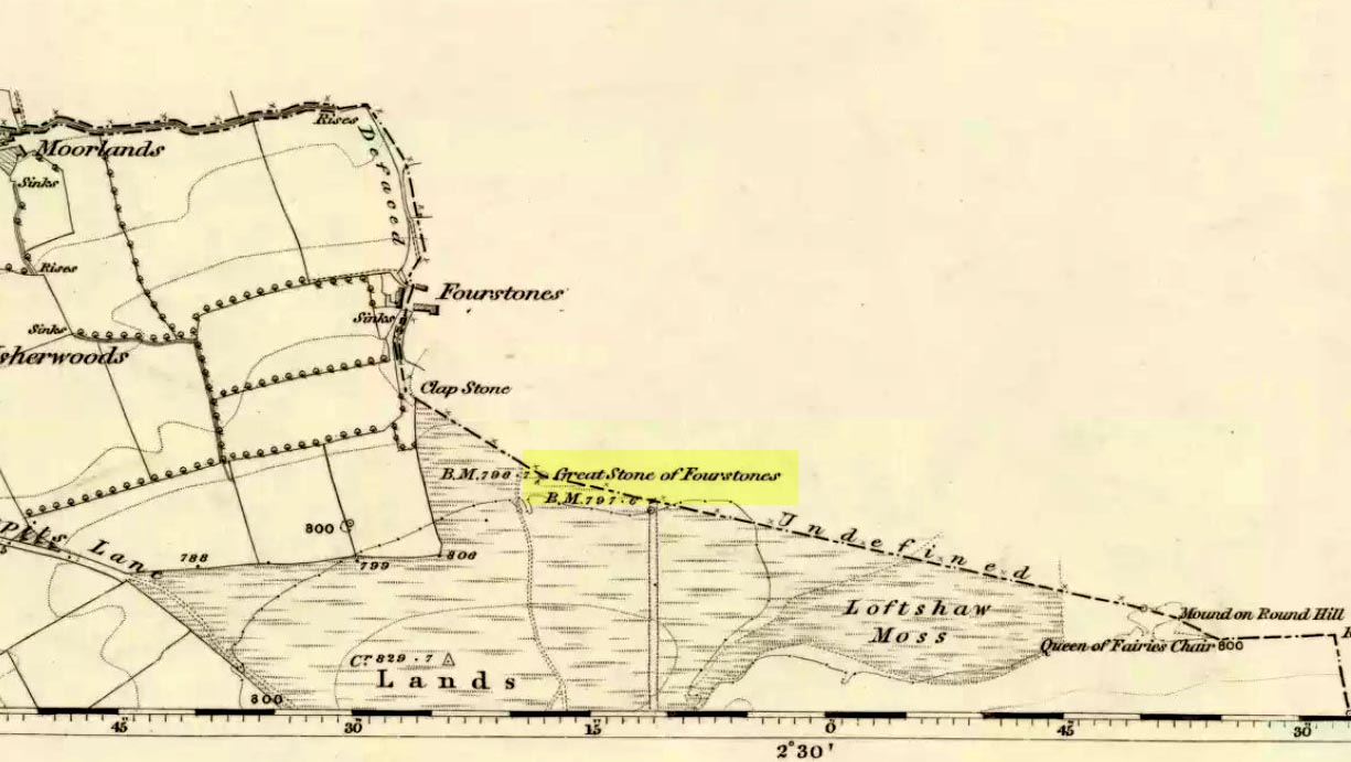
Great Stone on 1847 map
A meeting place of local tribes in more ancient days, the moorland plain upon which the Great Stone sits, beckons to a vast landscape on all quarters (north, south, east and west) calling the elders from their lands for annual rites and decisions to befit the health of the land and the people. The stone rests on the ancient boundary of Yorkshire and Lancashire, just on the Yorkshire side, and was visited annually in more later centuries during the beating of the bounds, to define the edges of the local township.
Graffiti & cup-marks on the top
First described in a Yorkshire inquisition account from 1307, this Big Stone was visited by Harry Speight (1892) who described it as measuring 30 feet round and 12 feet high. I came here for the first time in the 1980s when I was hitch-hiking into the Scottish mountains, but a good old “local” (from the Yorkshire side) took a detour to show me the place! Once here, I climbed up the very worn “steps” which were carved into the side of the boulder several centuries back and it didn’t surprise me to find a number of cup-markings (no discernible rings) on its top surface. When I came here again with Michala Potts and Paul Hornby yesterday, I couldn’t believe how many people had carved their names on top of the Great Stone in the intervening years — it’s almost covered in modern graffiti and the old cup-markings were much harder to see. Taylor (1906) mentions them briefly in his holy wells survey, saying how,
“This great boulder is ascended on its eastern side by fourteen steps, and on the top are two circular holes about two inches deep and two inches in diameter.”
There used to be three others boulders very close to this one (hence its title), making a natural stone circle, but they were “broken up for sharpening scythes” a couple of hundred years back. A much wider archaeological survey of this region is long overdue.
Folklore
Great Stone, looking east
Harry Speight (1892) told how the (original) Four Stones were the creation of our old friend the Devil, long ago, who dropped them in one his many megalithic travels across our land. The stones were also the meeting place of ancient councils, from the tribes either side of the Yorkshire-Lancashire border. Their presence here also had mythic relationship with the Queen of the Fairies Chair, about a mile southeast, along the same boundary line.
Weird how folklore changes. Whilst old Mr Speight told how the devil created the once great four stones that were here, many years later Jessica Lofthouse (1976) told how the three missing stones – which had been here “since the world began” – were actually taken from here by Old Nick. Carrying them over the land,
“His load he dropped on Casterton Fell, where the rocks he discarded, the Devil’s Apronful, are still lying around. He selected the most suitable, dressed them and carried them in panniers down to the (River) Lune”
— and built the legendary Devil’s Bridge at Kirkby Lonsdale – which itself has strange tales to tell. Another creation myth about the Great Stone is told on the plaque near the stone, alongside the footpath, which tells:
“Legend has it that it is a small part of the debris hurled by the giant Finn McCool across the Irish Sea in a fit of anger.”
It’s very obvious that a lotta mythic landscape material has been neglected and overlooked around this site. Something we need to remedy, if we can, in the coming years…
References:
Lofthouse, J., North Country Folklore, Hale: London 1976.
Speight, Harry, The Craven and Northwest Yorkshire Highlands, Elliott Stock: London 1892.
Taylor, Henry, The Ancient Crosses and Holy Wells of Lancashire, Sherratt & Hughes: Manchester 1906.
The Fairy Stone, on the south-west corner of Clunbury Hill, measures some 3ft by 2 ft 3 in and is some 2ft 6 in high. Local lore tells that it was once a standing stone, but this may not be the case; it’s thought more likely to be a simple glacial erratic. The stone is granite with quartz veins and stands very close to the local boundary line.
Folklore
Local researcher Jonathon Mullard found this stone, not surprisingly, to have “had a long tradition of fairy lights associated with it; they were said to appear at certain times of year.” And Mullard found one very intriguing encounter of these supernatural forms, later narrated in Paul Devereux’s (1990) excellent tome, which told:
“The legend would seem to relate to actual folk knowledge of the site, because Mullard was informed by an elderly woman living locally that she recalled her grandfather telling of an encounter with the lights. Returning home one evening across Clunbury Hill, he saw the whole area around the stone filled with small lights of a gaseous appearance bobbing up and down a short distance above the ground. Not wanting to go out of his way, the man walked through them. He found that any lights he happened to touch against adhered to his trousers. He briskly brushed them off, but found when he got home that the fabric was scorched. The woman had actually kept the trousers up until a decade or so before talking with Mullard!”
References:
Devereux, Paul, Places of Power, Blandford: London 1990.
From the scruffy Askwith Moor lay-by car-park, along Askwith Moor road, follow the fence north up along the roadside until you reach the gate on your right. Go thru this and head due west into the moor, towards the small cluster of other carved stones (carvings 581, 582, etc), particularly the Small Rings Stone (carving 579). Around here, you’ll notice a cluster of about 10 mounds in the heather, which seem to be prehistoric cairns, and this particular stone rest against the northwestern side of one of them, about 30 yards west of carving 579. If you’re patient, you’ll find it! (if you fancy a look at all these on the moor, gimme a shout & I’ll take you straight to ’em – but you need to make a booking!)
Archaeology & History
This carving takes a bitta finding amidst the mass of deep heather and open moorland and is probably only gonna be of interest to real cup-and-ring fanatics. But it’s the setting which makes it more intriguing — for me anyhow!
Trying to highlight the internal CnRSolar Stone carving
Like other carvings on this moorland, we find it in direct association with a prehistoric tomb (though it aint been excavated), resting up against the edge of one. However, it seems to have been moved from its original position and may, perhaps, have actually faced the other way at some time in the past. We might never know. However, some student in the recent past saw fit to name this small carving the ‘TV Stone’, thanks to the slightly cronky outline of an old television screen, with its small half-cup-and-ring near the bottom corner of the rock. You can see where they were coming from!
Boughey & Vickerman (2003) made only a brief note of the stone, seeing only the cup-and-half-ring here; but there seems to be a faint cup-marking near the middle of their TV screen, along with faded evidence of an incomplete ring around it. You can just about make it out in the poor photos we took of it. (sadly, we were without water when we visited it, which would have highlighted the additional cup-and-slight ring more clearly)
Close-up of cup-and-half-ring
We gave this stone the title ‘Solar Stone’* as it seems more appropriate and would certainly have more mythic relevance to the people who carved this. The curious natural ring, or TV outline, running round most of the stone (with the faded cup-and-part-ring near its centre) may have been attached with more animistic attributes than us moderns tend to give things — children notwithstanding! Circular forms in Nature have universal tendencies in more traditional cultures with such heavenly bodies as sun or moon, which might have been relevant here with the stones association with a tomb.
…Again, we might never know…
References:
Boughey, Keith & Vickerman, E.A., Prehistoric Rock Art of the West Riding, WYAS: Wakefield 2003.
* though did debate in somewhat primitive northern lingo: “Ugh – errr…solar? lunar? Ey? — Solar? Lunar?” uttering the same queried mantra numerous times between ourselves till we got tired and stuck with ‘solar’, as seems common these days (though I preferred ‘lunar’, it’s gotta be told!).
From Gilmerton village, take the A822 Dunkeld road north. Go for about 200 yards and take the little road to Monzie; watching carefully another 200 yards on for the dirt-track on the left taking you across the fields. Go along the track, watching out for the small stones in the field on your right less than 200 yards along. You can’t really miss ’em! This small ring of stones is the Monzie Cairn Circle. The carving is just in front of it!
Archaeology & History
Although we know this brilliant carved stone has some relationship with the Monzie cairn circle only five yards away (it was linked via a man-made stone causeway, running between the circle and the carving), the stone itself is very much deserving of its own entry here — and at the same time I can give Andrew Finlayson’s (2010) excellent book a decent plug aswell! (the superb drawings of the stone, top & bottom, are from Andy’s work)
Allen’s 1882 drawingCarving & proximity of circle
First mentioned (I think) in Simpson’s (1867) early survey, the carving was described soon after by J. Romilly Allen (1882), who gave us an early drawing of the stone. Thought by some to have originally stood upright, the carving was described by Aubrey Burl (2000) as being, “decorated with forty-six cupmarks, cup-and-rings, nine double, one triple, there are grooves and a pair of joined cups.” It’s certainly an impressive carving!
Although the carving has been posited by some archaeologists as an outlier to the Monzie circle, it’s probable that the circle emerged from the carving — a concept that some may find difficult to understand. I’m not aware of any modern excavations here (the last, I think, was in 1938), but my guess would be that the stone causeway laid between the cup-and-ring stone and the circle ran towards the circle from the carving, and not the other way round. The carving is probably older than the stone ring — though of course, without excavation, my idea could be utter bullshit! (there are also some cup-marked stones in the circle aswell – though none as impressive as this)
One of my truly favourite megalith fanatics (despite some of his alignments being out), Alexander Thom, came here and thought this old carving “coincided with a rough stellar alignment from the centre-point of the cairn” (Hadingham 1974); though his notes in Megalithic Rings (1980) tell that,
“from the cupmarked stone beside the circle, the midsummer sun sets above an outlier some 800ft distant.”
The “outlier” that Thom mentions is known as the Witches’ Stone of Monzie, which Simpson (1867) appears to have mistakenly thought was the name of this very carving.
References:
Allen, J. Romilly, “Notes on some Undescribed Stones with Cup Markings in Scotland,” in Proceedings of the Society of Antiquaries Scotland, volume 16, 1882.
Burl, Aubrey, The Stone Circles of Britain, Ireland and Brittany, Yale University Press 2000.
Finlayson, Andrew, The Stones of Strathearn, One Tree Island: Comrie 2010.
Hadingham, Evan, Ancient Carvings in Britain, Garnstone: London 1974.
Simpson, James, Archaic Sculpturings of Cups, Circles, etc., Upon Stones and Rocks in Scotland, England and other Countries, Edmonston & Douglas: Edinburgh 1867.
Thom, Alexander, “Megalithic Astronomy: Indications in Standing Stones,” in Vistas in Astronomy, volume 7, 1966.
Thom, A., Thom, A.S. & Burl, H.A.W., Megalithic Rings, BAR: Oxford 1980.
To get to Towneley Park head to the south side of the town close to a junction of two roads heading towards Todmorden and Bacup, from here the park and hall are signposted. The old cross stands 300 metres south-west of Townley Hall in the centre of some pathways leading in the direction of Todmorden road (the A671).
Archaeology & History
Foldys Cross, Burnley (Taylor, 1906)
Foldy’s Cross is a tall slender monument on a carved circular pedestal which sits upon a set of seven square-shaped steps. It dates from 1520 when it stood at the south side of St Peter’s parish church, Burnley. It was set up to commemorate a chaplain of St Peter’s church by the name of John Foldy or Foldys, and was then the town’s market cross or St Peter’s churchyard cross. In 1780 it was badly damaged by a Puritan mob, but the Towneley family rescued it and had it brought to their estate where it was repaired in a haphazard way and placed at the north-eastern side of the hall on the Avenue. In 1911 Burnley Borough Council had the cross completely restored for its Jubilee Year celebrations with various sandstone pieces added to replace sections of the cross including the plinth and set of seven steps – which are thought to be an exact copy of the original ones. The cross was then placed in its current position 300 metres to the south-east of Towneley Hall at an intersection of footpaths leading towards Todmorden road.
The original design of Foldy’s Cross was of the Gothic style which can be seen in the cross-head. It is made of sandstone and has an octagonal shaft with a moulded plinth with sunken panels. These panels contain lettering in the Gothic script. The cross-head is very nice with its decorated four arms, one of which is sunk into the shaft to support the head itself; this appears to be the original moulded head or cap with nicely carved emblems and fleurons on the collar – all typically Gothic in style. In the middle of the cross-head is a rather crude crucifix scene and on the other side the letters “IHS”. On the plinth the inscription reads in Latin:
‘Orate pro anima Johannes Foldys, capellani qui istam crucem fieri fecit Anno Domini MCCCCCXX’
— which when translated reads as, “Pray for the soul of John Foldys, chaplain who caused this cross to be made in the year of Our Lord 1520”.
The cross is now grade II listed and the English Heritage Building identity number is 467232.
References:
Peace, Richard, The Curiosities of England – Lancashire Curiosities, The Dovecot Press Ltd 1997.
Taylor, Henry, The Ancient Crosses and Holy Wells of Lancashire, Sherratt & Hughes: Manchester 1906.
From the centre of Stoke head west onto Glebe Street and just a couple of hundred yards or so south of the town hall is the minster church of St Peter Ad Vincula (St. Peter in Chains). Go into the large graveyard and there the ancient Saxon cross-shaft stands behind some modern iron railings. There are many other things of interest to see in the churchyard, including some old arches and monuments / gravestones in memory of some famous potters that made Stoke famous during the industrial revolution.
Archaeology & History
The Mercian cross-shaft stands 4 feet high on a 19th century square, socketed lump of stone. It is said to date from about AD 1000 when it was in use as a preaching cross, but could in fact be from earlier than that according to some local historians – perhaps it was originally a Christianized stone. The first Saxon settlement at Stoke (Stoiche) was said to date from c 800 AD. The cylindrical shaped shaft was discovered in 1876 by a gravedigger who spotted it being used as a door lintel inside the old church which was being demolished to make way for a newer church building. During its recovery the shaft broke in two so it was placed in storage, but in 1935 it was formally identified by Mr Charles Lynam who had it restored and re-erected in the churchyard.
Sadly the shaft is quite badly eroded with the carvings on one side being difficult to make out, but the front face has interlacing and scroll-work; there is some key-patterning on the sides and reverse side along with a series or section of small holes – these perhaps done in more recent times. The break across the middle of the shaft can still be seen today, but that does not detract from its great antiquity, the ancient monument being carefully restored. On the base there is an inscription that reads:
‘This fragment of a pre-Norman cross identified by Chas Lynam F.S.A. was re-erected near to its original position in the 25th year of the reign of H.M. King George V by P.W.L.Adams F.S.A.’
Within the Harris Museum, Preston can be found the Upper section of a pre-Conquest stone ‘cross’. Though much damaged on three of its sides the main face displays the upper section of a horned-helmeted figure holding a sword before it. The spreading horns suggest an important figure from the Viking period in Lancashire (c.900). This large and important piece of sculpture was found during the construction of Rivington reservoir on the River Yarrow near the village of Grimeford, Anderton in the 19th century.
Also found at that time during the reservoir construction was the lower section of a ‘cross’ shaft. This shaft is decorated on all four sides with carvings which include: the figure of a man from the waist down; a trellis filled with geometrical ornamentation of horizontal and vertical straight lines repeated to form a band known as a fret; a modified version of T-fret; and a combination of vine scroll and frets. The top of the shaft serves as the base for what is possibly a post medieval sundial base which has been adapted for use as a direction stone with directions to “Preston, Wiggan, Boulton, and Blagburn” (spelled as on the stone) being carved on the sides. I would suggest that the two fragments are parts of the same monolith and may even depict the Viking Gunnolf (the latter being my own fancy). This headless ‘cross’ is sited at the junction on the old road near the Millstone pub in Anderton and Grimeford Lane on the way to Rivington (SD 618 130). The stone is known as the ‘Grimeford Headless Cross’ or more locally as the ‘Headless Boggart’.
Folklore
Legend has it that there used to be a chapel near the junction and a tunnel running to a nearby farm on a hill. In the 16th century shortly before troops came to destroy the chapel, a priest hid in the tunnel and became trapped underground. His body was never found. Many people are said to have seen a ghost at the Headless Cross.
Addenda
To complement John’s entry, here are Mr Taylor’s notes written more than a hundred years ago in his Ancient Crosses and Holy Wells (1906), where he told:
“The HEADLESS CROSS — These words appear on the ordnance maps at a hilly spot in the extreme south-eastern corner of the hundred, five hundred feet above sea level, and distant one mile from the village of Adlington and about the same distance north from Blackrod. Both villages have histories going back into the far past… A ‘Windy Harbour’, near the cross, sufficiently indicates the breezy nature of the situation. The well and the ancient stocks are shown in close proximity to the cross. The remains of the stocks are still in existence.
“Respecting the Headless Cross and others in this locality, Mr J.W. Crompton of Rivington Hall, writes (February, 1899):
“‘In reply to your note, I never heard of any cross, ancient or modern, in Rivington proper. There was a tenement known as Butter Cross. Possibly some ancient cross may have existed there, but I know of no record to it. There used to be a Headless Cross in Anderton, but old Mr Ridgeway, of Ridgemont, removed it many years ago, when he had sporting rights rented in that township, and I believe and old road surveyor broke up a cross in Anglezark to repair his roads early in this century: his name was Gerrard. Crosses seem to have been specially erected to warn people of dangerous moors they were about to cross, and as a call to prayer in this part of the country, they were frequent.’
“…The subjoined deed is printed in the Chartulary of Cockersand Abbey, circa 1184-1190:
‘Grant in frankalmoign from Ranulf Gogard and his heirs to God [and the canons of Cockersand] for the health of the souls of his mother and his wife Edith, of all the land from Fulford to the path which crosses Rascahay Brook, between Heath Charnock and Adlington, as it was marked out by the crosses and marks of the said canons; with comon right of Charnock, in wood and plain, feeding grounds and mast in all other liberties.'”
References:
Taylor, Henry, The Ancient Crosses and Holy Wells of Lancashire, Sherratt & Hughes: Manchester 1906.