Pitcur Souterrain (3) – Carving 2, Kettins, Perthshire

Cup-and-Ring Stone:  OS Grid Reference – NO 25290 37378 

Getting Here

MacRitchie’s 1900 groundplan

Follow the same directions as if you’re visiting the Pitcur (3) souterrain.  Once here, you’re standing at the southernmost uncovered section of the monument, where one uncovered passageway bends round and meets up with another open section (“m” on MacRitchie’s plan, right).  From here, just to your right, a single large roofing stone joins one side of the open passageway with the other, enabling you to walk across it—and the stone you’d walk across has these very faint carvings on it.

Archaeology & History

Shortly before darkfall a few weeks ago, Nina Harris, Frank Mercer, Paul Hornby and I were just about ready to pack-up and leave the brilliant Pitcur souterrain with its underground chambers and various petroglyphs when, as I walked along one of the open passages beneath one of the monument’s many large capstones, my fingers gently stroked the rock above me, almost unconsciously.

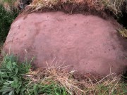
First photo of the carving (by Paul Hornby)

“Was that a faint cup-mark?” I asked myself, fondling gently the smooth stone once more.

Standing eight-feet above me in the long grasses, Mr Hornby was gazing around in his usual way.

“Paul – can you see from up there if this is a cup-marking I’m feeling here?”

Walking onto the edge of the rock itself, he proclaimed, “it looks like it!”

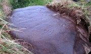
It was indeed!  And during the remaining 30 minutes of daylight we found that the single cup-mark had a number of companions on the same stone.  With multiple rings!  Twas another good day out.

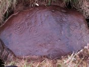
Carving when wet (photo, Frank Mercer)

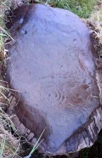
Looking straight down

Previously unrecorded, this large rounded stone just about covers the space across from one side of the souterrain passage to the other, measuring roughly 6 feet by 4 feet, with its longer axis positioned roughly east-west.  It was on the westernmost edge of the stone where I located the first single cup-mark, close to the edge, but there are perhaps 12  others: three of which, as the photos show, are in a straight line from near the west-side of the stone to the upper-middle.  On its far eastern edge, another cup-mark is clearly evident; whilst on its southernmost edge is another.  It’s the middle and eastern section of the rock that grabs most of the attention.  Here we found the very faint rings becoming clearer and clearer as the dust of ages was carefully swept away, eventually giving us vision of carvings that were, in all likelihood, first pecked into the rock in the neolithic period, 4-6000 years ago.

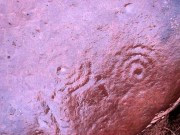
Close-up of the 2 triple-rings

Cup-and-rings at an angle

As we can see, two faint triple-rings exist, each with lines running in/out of them.  The eastern concentric system is just about complete and has a small cup-mark on the NW edge of the outer ring.  A line that runs out from the central cup meets another carved line which, from some angles, appears to look almost like a bowl beneath the triple rings—but this is unclear.  The other triple cup-and-ring, slightly closer to the middle of the stone, has an incomplete outer ring, with evidence of another line running outwards from its central cup. There seems to be a slightly-pecked outline of a single cup-and-ring on the north side of the stone, but this is also unclear.

In truth we need to revisit the site soon, when the lighting gives us a clear idea of what we actually found, because our visit here was cut short by encroaching night and a grey cloudy evening—which are not the best conditions for isolating new petroglyphs!

At least six other petroglyphs exist within the Pitcur Souterrain (3), with the one closest to this (Pitcur 3:3) also used as a roofing stone, covering the deep trench from one side to the other.  However, it would appear the petroglyphs on that stone were on its underside, as the erosion on it is negligible, away from the elements—unlike this one! Another capstone that was also turned over (Pitcur 3:4) was found to possess more cup-and-rings, again on the underside of the stone.

This carving was probably executed 2-3000 years before the souterrain came into existence, and as a result of this we’re unsure as to the original location of the stone—but it was probably close by.  It might have originally been a carved standing stone, re-used here; or been part of a lost prehistoric tomb; or even a loose earthfast rock (though this is the least likely of the three).  Why it was used, and whether it retained any sense of the original meaning when it was re-positioned into the present construction, is a relevant question.  In all likelihood some of the original mythic element—or a morphed development of its original animistic narrative–was probably a functional ingredient of importance to the souterrain builders, 2-3000 years after the carving had been made.

A superb site!

References:

  1. Wainwright, F T., The Souterrains of Southern Pictland, RKP: London 1963.

Acknowledgements:  This site profile would not have been made possible were it not for the huge help of Nina Harris, Frank Mercer & Paul Hornby.  Huge thanks to you all, both for the excursion and use of your photos in this site profile. 🙂

© Paul BennettThe Northern Antiquarian


Newtyle, Dunkeld, Perthshire

Standing Stones:  OS Grid Reference – NO 04489 41057

Also Known as:

  1. Doo’s Nest
  2. Druid’s Stones
  3. New Tyle

Getting Here

Newtyle’s standing stones

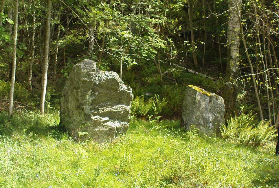
From Dunkeld travel southeast on the A984 road to Caputh and after about 1½ miles, set back a few yards from the road amidst the trees below the Newtyle Quarries (whose mass of slate and loose rocks cover the slopes), you’ll see these two large monoliths.  There’s nowhere to park here, but there’s a small road a coupla hundred yards before the stones aswell as a space to park on the verge by the side of the road a few hundred yards after them.  Take your pick!

Archaeology & History

When we visited these two tall standing stones a few weeks ago, guerilla archaeologist Hornby and I were a little perplexed at the state of these stones, wondering whether they were a product of the fella’s who dug the quarries above here, or whether they were truly ancient.  It seems the latter is the consensus opinion!

They were described by the great Fred Coles (1908) in one of his lengthy essays on the megaliths of Perthshire, where he thought the two stones here were all that remained of a stone circle that once stood on the flat, above the River Tay, but whose other stones “were destroyed in the making of the road” which runs right past here.  Not so sure misself!  He told that,

“An old cart-track runs up between the stones, leading from the main road…up to the quarry. The mean axis of the two stones runs N 13° W and S 13° E (true), and although their broader faces do not point towards the centre of a circle on the west, it is certainly much more probable that the other stones were on this side, the lower and flatter ground, than on the east, where the ground slopes and is more broken and rough.

“Both stones are of the common quartzose schist, but they differ considerably in shape.  A is 6 feet 7 inches high at the north corner, but only 4 feet 10 inches at the south, and its vertical height at the east is only 3 feet.  The basal girth is 13 feet 3 inches, and in the middle 15 feet 9 inches.  The broad east face measures 5 feet.  Stone B is level-topped and 5 feet in height; it has a basal girth of 12 feet 4 inches, and at the middle of 11 feet 8 inches.  Its two broad faces are of the same breadth.”

Little else was said of the two stones for many years and, to my knowledge, no real excavation has been undertaken here.  But when Alexander Thom (1990) visited the site he found that,

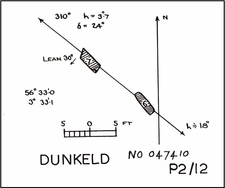
“This two stone alignment showed the midsummer setting sun.  The south stone may possibly, by itself, have shown the setting Moon at major standstill.”

Aubrey Burl’s description of the stones was succinct and echoed much of what Coles had said decades earlier, telling:

“Two very large stones stand only 9 feet (2.7m) apart in an unusually closed-in environment for a Perthshire pair.  The ground rises very steeply to the east.  To the west the stones overlook the valley of the River Tay.

“Both are of local quartzoze schist and are ‘playing-card’ in shape.  As usual it is the westernmost stone that is taller, 7ft 2in (2.2m) in height.  Its peak tapers almost to a point.  Conversely, its partner is flat-topped and only 4ft 9in (1.5m) high.  The pairing of such dissimilarly shaped stones has led to the interpretation of them as male and female personifications.”

Alex Thom’s groundplan
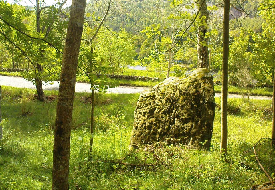
Back of the smaller stone

Burl’s latter remark thoughtfully recognises that such animistic qualities are found in many other cultures in the world and this ingredient was also an integral part of early peasant notions in Britain; therefore such ingredients are necessities to help us understand the nature and function of megalithic sites.  We must be cautious however, not to fall into the increasingly flawed modern pagan notion of such male and female ‘polarizations’, nor the politically-correct sexist school of goddess ‘worship’ and impose such delusions upon our ancestors, whose worldviews had little relationship with the modern pagan goddess fallacies, beloved of modern Press, TV shows and pantomime festival displays.

Folklore

In Elizabeth Stewart’s history of Dunkeld, she narrates the tale told by an earlier historian who told that,

“these two upright stones at the Doo’s Nest, but says they are supposed to mark the graves of two Danish warriors returning from the invasion of Dunkeld.”

References:

Burl, Aubrey, From Carnac to Callanish, Yale University Press 1993.
Coles, Fred, “Report on Stone Circles Surveyed in Perthshire – Northeastern Section,” in Proceedings of the Society of Antiquaries, Scotland, volume 42, 1908.
Stewart, Elizabeth, Dunkeld – An Ancient City, Munro Press: Perth 1926.
Thom, A., Thom, A.S. & Burl, Aubrey, Stone Rows and Standing Stones – 2 volumes, BAR: Oxford 1990.

© Paul Bennett, The Northern Antiquarian