Meikle Whitefield, Cargill, Perthshire

Stone Circle (destroyed):  OS Grid Reference – NO 173 342 (approximation)

Archaeology & History

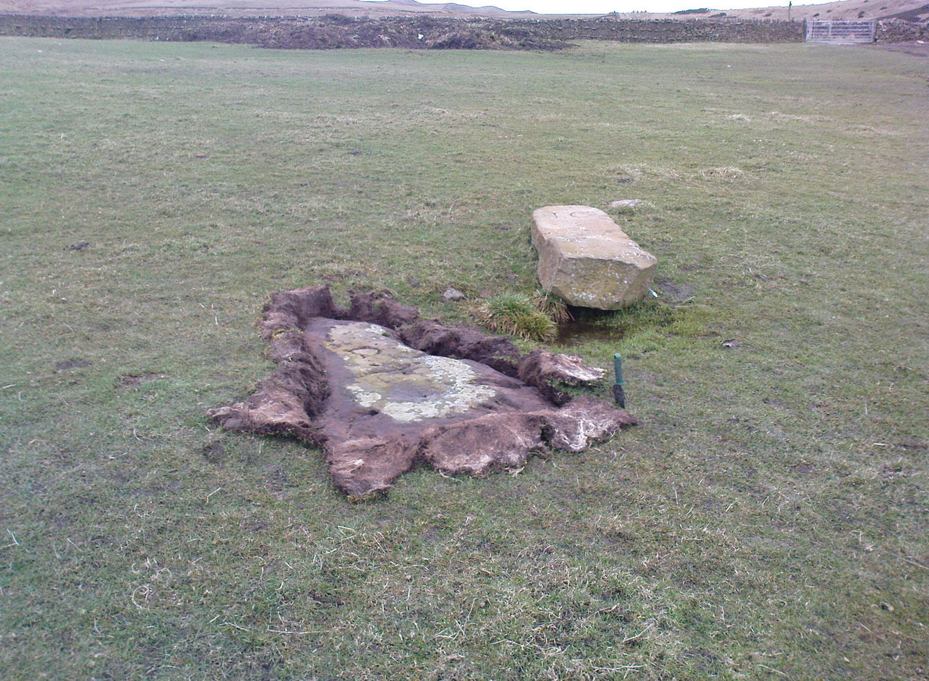
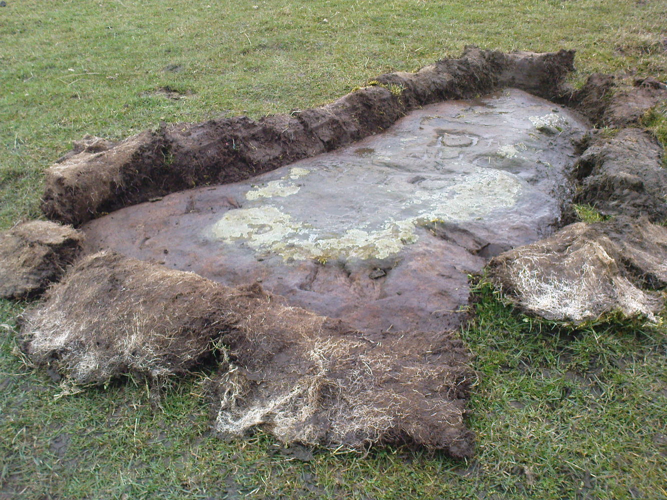
In an archaeological report by Alexander Hutcheson for the Scottish Society of Antiquaries in 1884, he described and illustrated an impressive cup-and-ring stone that was formerly built into the walls of a demolished house ¾-mile from its original position near Meikle Whitefield farm.  Upon destruction of that house, the farmer of West Whitefield—a half-mile from its original position—then moved the stone it into his front garden.  According to tradition, said Hutcheson, this stone

“was originally removed from a circle of stones, which had stood about half-a-mile eastward, but which have now been buried or broken up.”

Despite the local tradition, Hutcheson was some what sceptical of it, thinking that it

“seems very unlikely that such a weighty stone should have been transported for half a mile merely to serve as a foundation stone for a cottage, when the ground around was capable of supplying as many stones as would be required.”

You can see his point; but there are known circumstances where individual stones from megalithic rings have been preserved.  Hence, like John Barnatt (1989) in his magnum opus who preserved the folk memory of such sites, we include it here.  The tradition may well be valid.  Added to this is the fact that in just a few square miles hereby we once had a large cluster of stone circles, a few of which still remain.

Refeences:

  1. Barnatt, John, Stone Circles of Britain (2 volumes), BAR: Oxford 1989.
  2. Hutcheson, Alexander, “Notice of a Cup and Ring-marked Stone, and of Incised Stones Recently Discovered at Cargill, and of an Incised Boulder at Fowlis Wester,” in Proceedings Society Antiquaries Scotland, vol. 18, 1884.

© Paul BennettThe Northern Antiquarian

Town Cross, Kendal, Westmorland

Cross (destroyed):  OS Grid reference – SD 5152 9280

Also Known as:

  1. Cold Stone
  2. Market Cross

Archaeology & History

Not to be confused with the carved cross fragments held in the local church, this old town cross has long since gone.  It’s existence was recorded by the great Kendal historian Cornelius Nicholson (1861), but even in his day, this “obstruction” as he called it, was no longer standing.  Known as the local Market Cross where all the wheeling and dealing took place—official ones, as well as the not-so-official works of local folks—it stood just off Stricklandgate,

“opposite the Covered Market, and was an obstruction in the street.  There still remains a remnant of it in a stone at the corner, vulgarly called “cold stone,” where the charters and so forth were usually proclaimed.  Cold stone is a corruption of “call stone;” an appendage common to most ancient towns, where all public matters were “called” prior to the “institution” of belman.”

This folk etymology of “cold” needs to kept in mind when we come across other stones of this name.  …The earliest record of a market held at Kendal is from 1402, but written records of the Market Cross are scant until 1714. Such edifices tend to be architecturally ornate, but we have neither sketches nor descriptions of this lost site and must await the work of fellow researchers who may hopefully find out more.

References:

  1. Nicholson, Cornelius, The Annals of Kendal, Whitaker & Co.: London 1861.
  2. Smith, A.H., The Place-Names of Westmorland – volume 1, Cambridge University Press 1967.

© Paul BennettThe Northern Antiquarian

Glenballoch, Blairgowrie, Perthshire

Cup-Marked Stone (lost):  OS Grid Reference – NO 186 480

Archaeology & History

When J. Romilly Allen (1881) wrote about the megaliths and petroglyphs of Glenballoch, the owner of the property—a Mr George Harris—informed him of other archaeological finds in the locale: one of which was a cup-marked stone with distinct linear elements, whose description reminded me, slightly, of Ilkley’s Idol Stone.  It was found a short distance east of the Glenballoch (or Craighall Mill) stone circle.  Allen told how,

“Mr Harris…informed me that about twenty years ago he had dug up a stone with cup-markings upon it, on the opposite side of the valley to the south-east of the Glenballoch stone.  The stone lay horizontally with the cups uppermost.  It was split up and is now built into the out buildings of Glenballoch Farm.  The two largest fragments form the cover and sill of the hole through which the shaft of the threshing machine passes through the wall of the horse-mill, into the house.  A third fragment is built in above the window at the opposite side of the house, and is of greenish hue. Mr Harris expressed his great regret at not having known the value of this stone when he broke it up, and he is evidently proud of the stone which remains, and is determined that no ill shall befall it as long as he remains its guardian.  The cup marks on the stone which was broken appear to have been arranged symmetrically in two rows, and Mr Harris affirms distinctly that they were alternately circular and rectangular.”

These three stone fragments have not been seen since.  They may still be covered over in the spot Mr Harris described, but no one seems to have found them.  In the event that someone manages to find them, see if you can get a few good photos and stick ’em on our Facebook group.

References:

  1. Allen, J. Romilly, “Notice of Three Cup-Marked Stones, and the Discovery of an Urn, in Perthshire,” in Proceedings of the Society of Antiquaries Scotland, volume 15, 1881.
  2. Royal Commission on the Ancient & Historical Monuments of Scotland, North-East Perth: An Archaeological Landscape, HMSO: Edinburgh 1990.

© Paul BennettThe Northern Antiquarian

Cartington Cove, Rothbury, Northumberland

Cup-and-Ring Stone (destroyed):  OS Grid Reference – NU 0444 0186

Archaeology & History

In an area teeming with prehistoric sites from the neolithic and Bronze Age periods, we had a rare example here of some cup-and-rings that had been carved within a small cave or rock shelter of some kind.  Sadly it got destroyed in the mid-19th century due to quarrying operations—but not before George Tate (1864; 1865) had a final sniff of the place and was very lucky to see some of the remains before they finally bit-the-dust.  He told us:

“The great sandstone ridge ranges from Eglingham and Beanley across the central part of the county towards Rothbury, near to which is a cave in the rock called “Cartington Cove;” concentric circles with central hollows were incised within this cave.  Mr. Williamson of Alnwick, from whom I had this information, played around them when a boy more than fifty years ago; and they were then popularly called “Cups and Saucers.”  Nearly all of them have been destroyed by the wedges and hammers of quarrymen; but on visiting the spot in 1859, I found sufficient traces to confirm Mr. Williamson’s testimony.”

But they were gone a few years later thanks to the lads at the quarry.  Although the site was subsequently described in Beckensall’s modern surveys (1992; 2006), nothing more was found about them.

Folklore

Whilst David Dixon (1903) reiterated Mr Tate’s notes on the “series of incised concentric circles and central hollows” here, he also mentioned an old piece of folklore:

“At Cartington Cove (is) a recess or cave which, local tradition says, is connected by a subterranean passage with Cartington Castle, three miles distant!”

Intriguing ingredients: caves – Underworld journey – north – all symbolic of Death in pre-christian lore.  Just saying…

References:

  1. Beckensall, Stan, Prehistoric Rock Motifs of Northumberland – volume 2, Abbey Press: Hexham 1992.
  2. Beckensall, Stan, Circles in Stone: A British Prehistoric Mystery, Tempus: Stroud 2006.
  3. Dixon, David D., Upper Coquetdale, Northumberland, Robert Redpath: Newcastle-upon-Tyne 1903.
  4. Tate, George, “The Ancient British Sculptured Rocks of Northumberland and the Eastern Borders,” in History of the Berwickshire Naturalists Club, volume 5, 1864.
  5. Tate, George, The Ancient British Sculptured Rocks of Northumberland and the Eastern Borders, Henry Hunter Blair 1865.

© Paul BennettThe Northern Antiquarian

Yeavering, Kirknewton, Northumberland

Cup-and-Ring Stone (lost):  OS Grid Reference – NT 931 302

Archaeology & History

Little is now known of this carving which was described briefly by Stan Beckensall (1983):

“A cup and ring marked stone was found in the field north of Yeavering Bell in the neighbourhood of the monolith.  The last heard of it, according to the Northumberland County History (14:67) was that it was in the grounds of Ewart Park.”

The monolith he speaks of would be the one called the Battle Stone (NT 9299 3038) and Ewart Park is 2 miles ENE of here.  The carving remains lost. (the grid reference where the stone was originally located is an approximation, but a pretty good one)

References:

  1. Beckensall, Stan, Northumberland’s Prehistoric Rock Carvings – A Mystery Explained, Pendulum: Rothbury 1983.

© Paul BennettThe Northern Antiquarian

Thief Thorne, Draughton Moor, North Yorkshire

Standing Stone:  OS Grid Reference – SE 0405 5106

Getting Here

Thief Thorne Stone

Probably the easiest way here is to take the well-trodden Dales High Way track westwards, under the bypass from Addingham, and along the old Roman Road. After 1.7 miles (2.7km) you’ll reach the Heights Lane country road.  Stop here!  Walk back on yourself along the track for maybe 50 yards and look in the field to your right (south) between 10-20 yards in the short grass and there, somewhere under your feet next to a modern stone, you’ll see peeking up at you (probably somewhat covered on the whole by the soil) a long flat stone.  That’s what you’re looking for.

Archaeology & History

This old stone had been sought after by various groups and people for many years and I was fortunate to relocate it about thirty years ago, laid down and all-but-hidden beneath the grasses.  The stone appears to have been buried nearly 100 years earlier, because when Harry Speight (1900) wrote about it in 1900 he described it as still upright.  In more recent years, it seems that the farmer has put  a replacement stone next to its position with the letters “JC” cut  into it.  You can see it in the above photo.

Thief Thorne uncovered
Thief Thorne, looking W

First mentioned in the 16th century and included in boundary perambulation records of 1709, and again in 1781, someone during that period turned it into a milestone, etching the words “To Skipton 3 m. To Addingham 2 m.”  It stood by the old Roman road, but its considerable erosion and shape is decidedly prehistoric.  Nearly 6 feet long, it is now laid in the earth and almost completely covered over.  A sure case for resurrection.

References:

  1. Bennett, Paul, The Old Stones of Elmet, Capall Bann: Milverton 2001.
  2. Speight, Harry, Upper Wharfedale, Elliott Stock: London 1900.

© Paul BennettThe Northern Antiquarian

Giant’s Grave, Cloghfin, County Donegal

Chambered Cairn (destroyed):  OS Grid Reference – H 277 998

Archaeology & History

Included in Eamon Cody’s (2002) magnum opus, this site has long since gone.  It was highlighted on the 1845-47 OS-map of the area and the only subsequent information about it was written in the 1903 Ordnance Survey Name Book, where it was described as a “supposed Giant’s Grave” that was marked by a large spread of boulders.

Perhaps the only thing we can ascertain here is from the name Giant’s Grave.  Invariably, giants are part and parcel of creation myths in early traditional societies.  Such giants, as well as being huge mythical creatures, can also be the progenitor of tribes and communities, i.e., the person who laid the initial foundation of where the tribe came to live, usually an early queen, king or shaman figure.  So, in the case of this Giant’s Grave, it was likely to have been known as the burial place of such a figure: mythical in importance as well as size.

References:

  1. Cody, Eamon, Survey of the Megalithic Tombs of Ireland: Volume VI – County Donegal, Duchas: Dublin 2002.

© Paul BennettThe Northern Antiquarian

Trows Well, Birsay, Orkney Isles

Sacred Well:  OS Grid Reference – HY 26157 26838

Archaeology & History

On the northwest side of the Loch of Boardhouse can still be found a spring of water which was, in bygone times, the abode of the supernatural creature known as the troll or trow.  The site is described in local place-name records and is located near the foot of a slope near Westerhouse, from where a small channel of water runs down into the Loch of Boardhouse about forty yards away. When it was last described in the 1960s, all folk memory of its heathen inhabitants had seemingly been forgotten and no folk-tales seem to have been recorded.  Thankfully, the Well itself is still shown to exist on modern OS-maps.

© Paul BennettThe Northern Antiquarian

Moses’ Well, Morton, Thornhill, Dumfriesshire

Holy Well:  OS Grid Reference – NX 8799 9431

Archaeology & History

Moses Well on 1861 map

This little-known Biblical-sounding spring has apparently long since fallen back to Earth (perhaps there might be some local folk who could find out for certain).  Shown on the 1861 Ordnance Survey map as being at the side of the wall in the small copse of trees—immediately east of kirk- place-names and a half-mile north of St Ninian’s Well—it was briefly described by T.C. Ramage (1876), who seemed to know nothing of its lore, merely telling us that,

“on Templand farm, close to the wooden bridge over the Cample, there is Moses’ Well, an unusual designation, but which some Knight Templar may have given in remembrance of his toils in Palestine.”

The Templar designation was deemed by Ramage to come from the name of the farm.  However, a few years prior to this, the early Scottish place-name surveyors were traversing the area and found from local people how it derived “its name from a Tinker named Moses Marshall who with his family lived near it in a Camp during the time they had the small pox.”  The Well was also included in the Morris survey (1982), but without comment.  Another Moses Well can be found 44½ miles to the northeast, near Galashiels at NT 4046 4306.

References:

  1. Morris, Ruth & Frank, Scottish Healing Wells, Alethea: Sandy 1982.
  2. Ramage, Craufurd T., Drumlanrig Castle and the Douglases, J. Anderson: Dumfries 1876.

© Paul BennettThe Northern Antiquarian

Cotterton, Moulin, Perthshire

Standing Stone:  OS Grid-Reference – NO 03818 63692

Also Known as:

  1. Straloch

Getting Here

Cotterton standing stone

Along the A924 road, just over 4 miles (6.6km) NW from Kirkmichael, or about 8 miles (13km) NE from Pitlochry, you’ll hit the large farmhouse of Straloch.  You’ve really gotta keep your eyes peeled!  A few hundred yards west of Straloch itself, a small parking spot is on the south-side of the road, above the river.  From this parking spot, walk a few yards to the fence that overlooks the river and look into the field below you, where you’ll see the stone.  If y’ walk down the slope, you’ll see a gate on the right that leads you into the field.

Archaeology & History

First shown on the 1900 OS-map of the area, this petrified hunchbacked witch-of-a-stone stands on the flat grassland plain (previously scattered woodland when first raised) forty yards from the River Brerachan: a proximity characteristic found at many of the stones along Strathardle.

Cotterton stone 1900 map
Fred Coles’ sketch

Descriptions of the site prior to 1900 seem non-existent (does anyone know otherwise?).  It was the brilliant antiquarian Fred Coles (1908) who, it seems, was the first to mention the old stone — whose very crooked appearance had an unusual effect on him, saying how “such a decided leaning over towards the north…almost make one uneasy when standing beside it”!  It didn’t have that effect on me, but I was mightily impressed by both its appearance and curious hunched gait.  Twas one of those monoliths that had a distinct ‘feel’ about it, which many people report at such places up and down the country.  Whether it was its position by the river, or the color of the landscape, or the silence, or the shape of the stone, or combinations of them all—which ever it was, there was almost a sense of genius loci residing here…

But in that other world of pragmatic measurements, as Mr Coles told us:

“The Stone is at the base an oblong in shape, measuring 14 inches on its east end, 2 feet 7 inches along its south side, 17 inches at the west, and 3 feet 6 inches on its north side—a girth, therefore, of 8 feet 8 inches.  At the middle its dimensions are the same, but the top is rather less.   At its N.E. apex the Stone is 7 feet 8 inches clear of the ground, and at the west edge 7 feet.  In the illustration…I have shown the monolith from the south, with the craggy profile of Menachban in the background.”

The stone was mentioned in passing in Hugh Mitchell’s (1923) local survey.  A few years later in John Dixon’s (1925) account he repeated the dimensions of the stone that Coles had cited; and although he found there to be no known traditions of the place, he conjectured how it may have been connected with the numerous battles “that in former days occurred along this entrance to the Highlands.”

It’s a damn good site is this.  All you megalith hunters will love it!

References:

  1. Anonymous, Notes on Strathardle, Strathardle 1880.
  2. Coles, Fred, “Report on Stone Circles Surveyed in Perthshire – Northeastern Section,” in Proceedings of the Society of Antiquaries of Scotland, volume 42, 1908.
  3. Dixon, John H., Pitlochry, Past and Present, L. Mackay: Pitlochry 1925.
  4. Mitchell, Hugh, Pitlochry District: Its Topography, Archaeology and History, L. Mackay: Pitlochry 1923.

© Paul BennettThe Northern Antiquarian