Stone Circle (destroyed): OS Grid Reference – SP 470 464?
Also Known as:
Ringstone Well
Archaeology & History
In 1239 CE we find records of a field-name site called “Ringstoneswelle.” Although the place-name writer Margaret Gelling (1954) initially ascribed this as the watering-place of some dood called Hringstan, it is in fact the only record that I’ve found of a “stone circle by a well” in the village. This etymological root is confirmed in A.H. Smith’s English Place-Name Elements (vol.1, p.265) as a probable stone circle.
Folklore
There is also the curious field-name legend of a place in Cropredy called Kirk or Church Piece, where a christian church was being built, but in the morning all the stones had been uprooted & moved back from whence they came. This happened several times according to the folktale – a story that has with all the hallmarks of a megalithic site. (see Grinsell’s Folklore) To me it seems likely that the nearby Cup and Saucer Stone also had something to do with this lost stone circle.
In the same area we have another intriguing bit of folklore that was reported in an early edition of the Banbury Guardian (1932) which told that,
“on one of the top stones of a wall in front of one of the farmhouses is what is supposed to be the Devil’s footprint and there are nail-marks in the stone, but how it gots it name is a puzzle. At the back of the vicarage gardens is a small jetty called HellHole, the old ‘Old Man’ must have visited this village a time or two.”
Are there any local antiquarians or historians who can throw further light on this seemingly lost megalithic ring?
References:
Anonymous, ‘Cropredy and its Legends,’ in Banbury Guardian, December 29, 1932.
Bennett, Paul & Wilson, Tom, The Old Stones of Rollright and District, Cockley: London 1999.
Gelling, Margaret, The Place-Names of Oxfordshire – volume 2, Cambridge University Press 1954.
Grinsell, Leslie V., Folklore of Prehistoric Sites in Britain, David & Charles: London 1976.
Smith, A.H., English Place-Name Elements – Part 1, Cambridge University Press 1954.
From Ripponden, taken the steep road up to Barkisland, but at the crossroads just before the village, turn right (south) and keep going for a mile till you reach the reservoir. At the far-end of the reservoir, take the track down by its side and follow the footpath that bends round the edge of the grasslands. Go up onto this small moorland and, once you’re on the level, head towards where you’ll see a large pile of stones a coupla hundred yards away. That’s it!
Archaeology & History
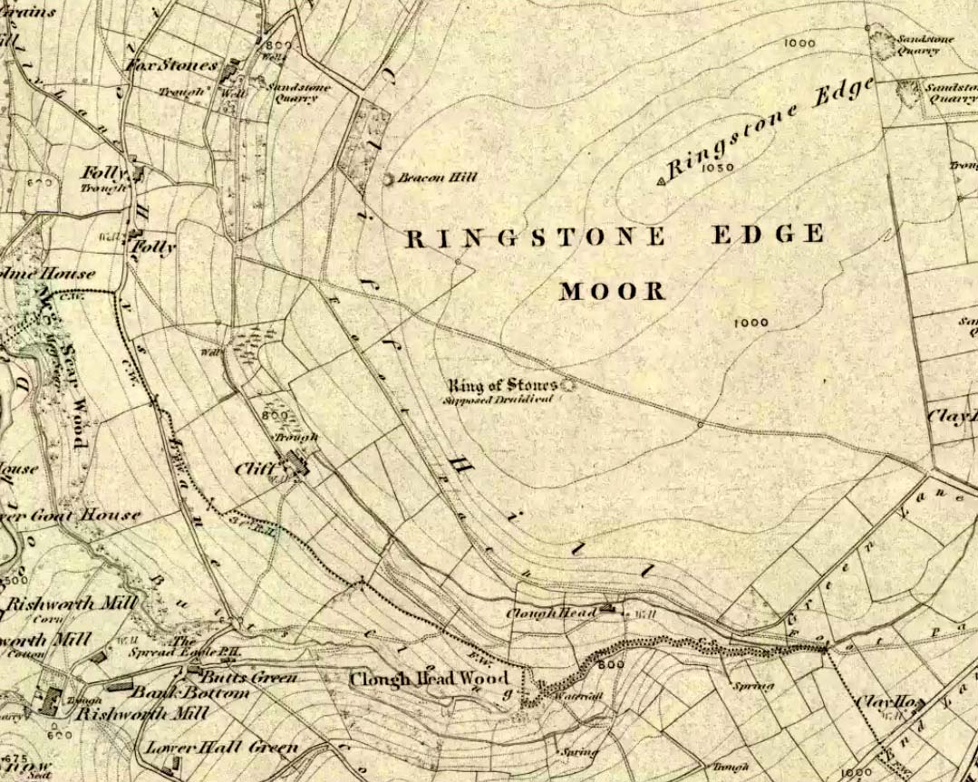
If we visit this site today, all we are left with is a scattered mass (or perhaps that should that be ‘mess’) of many hundreds of stones: the last remnants of what once would have been a proud circle of one form or another upon this small moorland plain. Its significance was such that the very moor on which its remains are scattered, was named after it: the Ringstone Edge Moor. But as with many sites from our megalithic period, this old place is but a shadow of its former self.
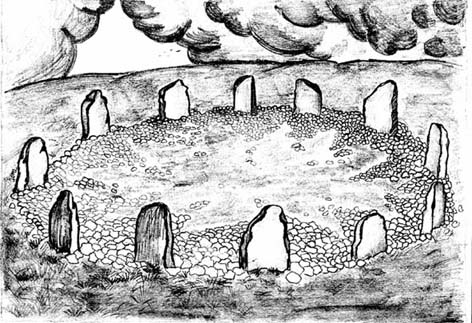
Gone are the upright monoliths which, tradition relates, once surrounded this low scattered circle of small loose stones (which would have made it look not unlike the wonderful stone circle of Temple Wood, Argyll). These standing stones were, so the folk record tells, removed near the end of the 18th century for use in some walling.
Described variously as a stone circle, ring cairn, cairn circle, an enclosure, and more, the site first seems to have been written about in 1775 by the great historian John Watson. When he was vicar of the local parish in Halifax (not far from here) this “ring of stones” as he called them, was “called the Wolf-fold.” Nearly one hundred years later, in F.A. Leyland’s superb commentary to Watson’s work, he wrote,
“The stones which constituted the circle at the time of their removal stood upwards of three feet…and the remain formed a striking object on the moor. The original number of stones of which the circle was formed is unknown, having long been in ruin and reduced in quantity before being finally removed. This was effected about twelve years since by the present tenant of the dam.” – that is, around 1859.
However, when Crabtree (1836) described the circle a decade or two earlier, he made no mention of such standing stones — although we must consider that Crabtree was very much like many modern academic archaeologists who tended to copy the works of others, much less than getting out in the field to see for himself.
At the beginning of the 20th century, the lore telling of the standing stones’ demise was repeated by local historian John Priestley (1903), when he said that: “all the large stones…were carted away about forty years ago” — that is, around 1863.
So it would seem that the very final destruction of the standing stones here, occurred sometime during the four year gap which Messrs. Leyland and Priestley describe.
More than fifty years later, Huddersfield historian James Petch (1924) came here to explore whatever remains he could find, and told:
“On top of a flat plateau on this moor, with an extensive view on all sides save on the north, where there is a gentle slope for some hundreds of yards up to the summit of the hill, there are distinct traces of a circular ring of small stones. Pygmie flints have been picked up within a yard or two, but the only other fact to be noted about this earthwork is that there is a tradition to the effect that much earth has been removed from this site. It is not altogether impossible that this is a scanty remnant of a round barrow.”
This latter remark of Mr Petch seems most probable. The excessive scatter of small stones typifies the remains of many of the Pennine giant cairns, from the Little Skirtful on Burley Moor and giant tombs of the Black Hills near Skipton, to the similar monuments of our Devil’s Apronful, Pendle, etc, etc.
Close to this cairn circle, wrote Sidney Jackson (1968), there used to be the remains of an Iron Age settlement, “marked by wall foundations (but) is now covered by the waters of Ringstone Reservoir.”
Folklore
There is very little folklore that I’ve found here. Watson (1775) throws the usual idea that the place was a site of druidical worship; but other than that we only have a local Ripponden writer’s account, which told that there was once the ghost of a white lady that was once said to walk along the path somewhere between here and the Beacon Hill tumulus, a short distance to the north.
Various ways to get here. From Worsthorne village, go east, up past the church, uphill following the dead straight path. After about 600 yards there’s a crossing in the footpath: go left here and walk another coupla hundred yards, over 2 walls, and after you’ve past the second wall you’ll notice the earthworks in the ground to your right. That’s it!
Archaeology & History
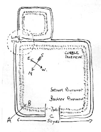
There’s nowt much to see here to be honest. It was included in Walter Bennett’s (1946) survey of ROMAN remains (oh dear) in the region — and his archaeological description of this place certainly seems to imply it was those doods (the Romans) who built this structure and not our neolithic ancestors. He wrote:
“Ringstones is a rectangular enclosure 50 yards square, surrounded by a mound or rampart 2 yards wide and one yard high, and an outer ditch two yards wide. Sepereated from the main enclosure by the ditch on the southeast side is another enclosure 18 yards square. Excavations made in 1925 gave the following information: a gateway, seven yards wide, was paved with boulder stones regularly laid on a gravel foundation, and on the south side of the gateway flat stones were sunk below the general floor level to act as a drain; a regular course of large stones flanked the gateway entrance on either side, and a foundation or irregular boulder stones was laid outside the gateway between the rampart and the ditch: inside the enclosure and 9 inches below the present grass surface., a floor had been made of gravel in some places and of flat stones or cobbles in others; the rampart was of earth and stones; a well-constructed road, 7 feet wide, ran from the earthwork in the direction of Bottin Farm, wich is situated on the Worsthorne-Roggerham road.”
There used to be a rough circle of stones on top of the site (probably giving the place its name), but these were apparently from the old remains of a lime-kiln from the 16th or 17th century — not prehistory. There is, therefore, a case that this site may not be prehistoric as archaeologists have classed it — and if the ground-plan above is anything to go by, you’d have to say it looks less than promising. More diggings are needed!
Attributed by Michael Dames (1996) and others before him as the abode of the Dagda and the house of the sun, this huge monument was recorded in the Irish Annals as being destroyed in 1101 AD following a great battle. A site of mythic importance to the very early Irish Kings and Queens, and used by the shamans of the tribes, The Grianan is a place of of legendary importance to folklorists, historians and archaeologists alike and has been widely described over the last 150 years. Although the site you see today was hugely reconstructed between the years 1874 and 1878, it’s still impressive and, wrote George Petrie (1840), commands,
“one of the most extensive and beautifully varied panoramic prospects to be found in Ireland”!
Used over very long periods of time, the archaeologist Brian Lacy (1983) described the Grianan, on the whole, as,
“a restored ‘cashel’*, centrally placed within a series of three enclosing earthen banks; the site of an approaching ‘ancient road’; and a holy well.”
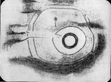
Early ground-plan of the Grianon
Lacy’s description in the Donegal Inventory is considerable and culls from the various surveys and reports done in the past. First surveyed by George Petrie in 1835, the internal body of the stone-built site is roughly circular and measures around 25 yards across, with a singular entrance on its eastern (sunrise) side. A stone ‘seat’ is at the end of the internal passage. At the centre of the huge ‘room’, Petrie recorded traces of a rectangular stone structure that he thought might have been the remnants of some old chapel built sometime in the 18th century.
More than 25 yards outside of the primary stone building is another surrounding embankment, oval in shape, low to the ground and with another singular entrance to the east — though this entrance is not in line with that of the main structure. At a further distance out from this embankment are the remains of another two oval ‘enclosures’, though the the remains of the outermost one is considerably more fragmented.
Although the replenished ‘fort’ dates from the Iron Age, early remains here are thought to have been of Bronze Age origin. A ‘tumulus’, now gone, being one such find here.
Folklore
There is much legend here. The creation myth narrated by Scott (1938) tells that it was,
“built originally by the Daghda, the celebrated king of the Tuatha de Danann, who planned and fought the battle of the second or northern Magh Tuireadh against the Formorians. The fort was erected around the grave of his son Aeah (or Hugh) who had been killed through jealousy by Corgenn, a Connacht chieftain.”
From similar legendary sources, it is told that,
“the time to which the first building of Aileach may be referred, according to the chronology of the Four Masters, would be about seventeen hundred years before the christian era. There are strong grounds for believing that the Grianan as a ‘royal’ seat was known to Ptolemy, the Greek geographer, who wrote in AD 120. In his map of Ireland he marks a place, Regia…which corresponds fairly well with its situation.”
By the outer banking on the south-side of the fortress is the remains of a much-denuded spring of water, the old water supply for this place. It gained the reputation of being a holy well, dedicated to St. Patrick.
References:
Dames, Michael, Mythic Ireland, Thames & Hudson: London 1996.
Harbison, Peter, Guide to the National Monuments in the Republic of Ireland, Gill & MacMillan: Dublin 1982.
Lacy, Brian, Archaeological Survey of County Donegal, DCC: Lifford 1983.
Petrie, George, ‘The Castle of Donegal,’ in Irish Penny Journal, 1, 1840.
Scott, Samuel, ‘Grianan of Aileach,’ in H.P. Swan’s Book of Inishowen, Buncrana 1938.
Swan, Harry Percival, The Book of Inishowen, William Doherty: Buncrana 1938.
Although ascribed as a holy or healing well, this site is actually a curious natural water-filled depression near the top of Dun I, on the northern side of the island. It is one of three magickal wells to be found hereby. F.M. McNeill (1954) described this Well of Eternal Youth as having a fame that had spread far and wide, saying,
“Here, through ages past, pilgrims of each generation have lingered at the enchanted hour of dawn, ‘to touch the healing water the moment the first sun-ray quickens it.'”
In doing so, devotees would recover the energies of youth once more and live a longer healthy life.
References:
Hannan, Thomas, Iona and some Satellites, W. & R. Chambers: London 1928.
McNeill, F. Marion, Iona, Blackie & Sons: Glasgow 1954.
Takes a bitta finding – especially if some dood’s knocked it down again (as happens up here). Best thing to do is get to the Miller’s Grave prehistoric cairn, which is only a few hundred yards away. From Miller’s Grave, walk due west for 200 yards till you hit once a ditched footpaths, where you should turn right. A short distance along you’ll hit a 5-foot-tall boundary stone called the Greenwood Stone with ‘1775’ carved on one side. From here, walk due south into the heather for 75 yards. You’re very close!
Archaeology & History
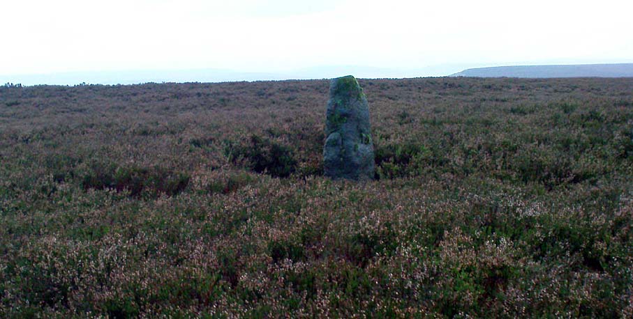
We resurrected this old standing stone in 1996, several years after first discovering it laid amidst the heather in the early 1990s. It appeared to mark an old boundary line (no longer used) betwixt Wadsworth Moor and Midgley Moor, but its nature is distinctly prehistoric. The remains of a small hut circle (seemingly Bronze Age, though excavation is needed) can be found a short distance to the west, though this is hard to find when the heather has grown. Other seemingly prehistoric remains scatter the ground nearby, none of which have received the attention of archaeologists.
Greenwood ‘B’ on a grey day
As you can see from these grey, rain-swept images, this upright stone is well-weathered (though we need to visit here again soon and get some better photos). It stands some 4-feet tall and may have accompanied one or two other monoliths close by. The suggestion by one Peter Evans that the Greenwood B stone stood “possibly at the centre of a stone circle” is sadly untrue (soz Peter); though it probably had some relationship with the Millers Grave cairn site, a few hundred yards equinox east.
References:
Bennett, Paul, The Old Stones of Elmet, Capall Bann: Milverton 2001.
Easy to find if you go at the right time of year — very troublesome to find if you go at the wrong time! Check the place out at the end of winter, beginning of Spring. It’s at the top end of Shipley Glen, just past where the road bends round and goes uphill. About 50 yards up, on the left side of the road walk into the grasslands for less than 100 yards. Look around!
Archaeology & History
An intriguing site this one. Intriguing as it wasn’t in the archaeological registers when I first came across it — and I’m really unsure whether it’s in there now. It probably has, as John Barnatt came here with some earth-mystery folk in 1982! But when I first visited this site in 1975 it seemed no one knew about it — and little has changed since then.
It is an enclosed ring of stones less than 30 feet across with an earth embankment separating it from what seems like a secondary ring on its outer edge, a foot or two away. This didn’t appear to surround the complete ring and may have been damaged. It had an appearance similar in size, shape and form to the Roms Law and Harden Moor sites, and thankfully in reasonable condition. I don’t think any excavation has yet been performed here though.
There are a number of other small standing stones on the outskirts of this ring that may have some relationship with the site, but we need excavation to prove one way or the other. Several very well-preserved cup-marked stones are close by.
Folklore
Intriguing to those of you who are fascinated by alignments between sites, or ‘leys’, as an impressive lines runs through this site. Starting at the little known Hirst Woods Circle and terminating at the giant Great Skirtful of Stones cairn, once passing over the now destroyed Weecher circle and the Brackenhall Green ring on its way.
References:
Bennett, Paul, The Old Stones of Elmet, Capall Bann: Chieveley 2001.
Tumulus (destroyed): OS Grid Reference – TF 232 018
Archaeology & History
Very little was known about this now lost burial mound. It was one of several nearby but, thankfully, the local historian and archaeologist E. Thurnam Leeds (who once lived at the nearby Eyebury Farm) sent a letter to the Society of Antiquaries in London, describing some pottery and other remains that he’d found there:
“The small pot of a late Bronze Age type and the other sherds exhibited were found in a tumulus known as Oliver Cromwell’s Hill, at Eyebury, near Peterborough. As only a portion of the tumulus has been examined as yet, it is proposed to defer a full account of the excavations until further progres has been made. The tumulus is of the round type, about 40 yards in diameter and 5 feet high at the centre. On three sides traces of a ditch were met with, containing soil which had evidently been burnt. Close to the gravel in the centre of the tumulus there were two distinct layers of charcoal, and in two places apparently remains of hearths. The small pot was found only 1½ feet down on the south-eastern side of the mound, 39 feet from the centre. In the centre itself at various depths were found sherds, some of Bronze Age forms; but a pice of a rimmed vase found at a depth of 3 feet 6 inches, about 6 inches above the first charcoal layer, appears to be of Roman date, in which case the centre of the tumulus must have been disturbed in those times, though the charcoal floors were never pierced. Bones of various animals, including sheep, pig, dog and hare, and a large flint flake were also found.”
As far as I’m aware, no further detailed examinations took place at this curiously-named hillock, whose folktale I’ve yet to read.
References:
Leeds, E.T., ‘Letter,’ in Proceedings of the Society of Antiquaries, 22:1, 1910.
The great Huddersfield historian, Philip Ahier (1948), in describing the lack of documentary evidence for several crosses in the neighbouring region, “at Deighton, Cowcliffe, Marsh and Golcar,” found out that,
“One did exist at Slaithwaite in front of the Manor House in the early past of the last century. In March 1931, the base of this cross, commonly known as the Dial Stone, was removed to Doughlas in the Isle of Man, where it rested in the garden of Mr Harry Wood; in August 1939, it was brought back to Slaithwaite and now stands in the Recreation Park.”
However, this site differs from another two that I’ve found records for on the outskirts of this township. Does anyone know what became of this old stone cross? Izzit still about? Its folk-name of the Dial Stone may make it a little easier to locate — but at the same time it does bring up the query, Why was it called that?
References:
Ahier, Philip, The Story of the Three Parish Churches of St. Peter the Apostle, Huddersfield – volume 1, Advertiser Press: Huddersfield 1948.
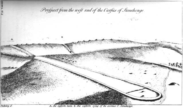
Not far south of the smaller Lesser Cursus monument, this huge linear earthwork was the very first cursus to be described, by William Stukeley no less, who thought it to be an old race-course for charioteers and the like! He stumbled upon this: a curious gigantic linear earthwork feature, stretching for nearly two miles roughly east-west and as wide a football field, cut into the Wiltshire Earth, betraying all notions of ‘primitive’ histories as proclaimed by the ‘intellectuals’ of his day. They were clearly wrong! This immense enigmatic structure, still baffles the same creed of intellectuals to this day — but at least our old ancestors have been granted greater abilities than previously believed. In his book on Stonehenge in 1740, Mr Stukeley described this,
“most noble work, contriv’ed to reach from the highest ground of two hills, extended the intermediate distance over a gentle valley; so that the whole cursus lies conveniently under the eye of the most numerous quantity of spectators. To render this more convenient for site, it is projected on the side of more rising ground, chiefly looking towards Stonehenge. A delightful prospect from the temple, when this vast plain was crowded with chariots, horsemen and foot, attending these solemnities with innumerable multitudes.”
Sir Norman Lockyer propounded its function as astronomical, aligning with the Pleiades around 2000 BC — a date we now know to be inconsistent with its construction, although as John North said in his Stonehenge (1997):
“Lockyer’s chronology was certainly better than the general archaeological consensus at the time.”
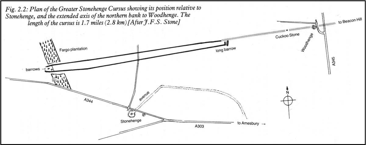
But further archaeological alignments and leys have been suggested running eastwards from here. And as Paul Devereux pointed out, “In the case of this cursus, archaeology got there first.” J.F.S. Stone, who carried out some excavations at the cursus in 1947, noted that
“its axis, if projected 1500 yards east, strikes Woodhenge and passes the Cuckoo or Cuckold Stone by the way.”
This was endorsed in 1981 by archaeologists John Hedges and David Buckley:
“In addition to aligning upon Woodhenge, the Greater Stonehenge cursus also sights upon the Cuckoo or Cuckold Stone.”
Alignment to Beacon Hill
In Roy Loveday’s (2006) survey of cursus monuments he told how this alignment goes much further, telling how it aligns “on the lower, northernmost prominence of Beacon Hill 8km away”, crossing Woodhenge on its way. Such suggestions used to bring outcries of derision from the archaeological fraternity, but it seems archaeologists themselves are making such claims more and more these days. At the forefront of modern alignment research in previous decades was Paul Devereux — and it was he who first noted the line-up with the distant Beacon Hill from the Great Cursus, telling:
“The course of the alignment can be extended eastwards a few miles beyond Woodhenge to cross the barrow-dotted ridge of Beacon Hill — a perfect example of a Wakins-style ‘initial point.’ The ridge is highly visible from Woodhenge. It disappears from view as one walks westwards down the cursus, but reappears clearly as the west end is approached. Indeed, the west end is so placed that it is at about the furthest point from which the Beacon Hill ridge , and the intermediate on which the eastern end of the cursus fall, can be seen together.”
…to be continued…
References:
Burl, Aubrey, A Brief History of Stonehenge, Robinson: London 2007.
Hedges, John & Buckley, David G., The Springfield Cursus and the Cursus Problem, Essex County Council 1981.
Loveday, Roy, Inscribed Across the Landscape, Tempus: Stroud 2006.
North, John, Stonehenge, Harper-Collins: London 1997.
Pennick, N. & Devereux, P., Lines on the Landscape: Leys and other Linear Enigmas, Hale: London 1989.
Stone, J.F.S., ‘The Stonehenge Cursus and its Affinities,’ in Archaeological Journal, 104, 1947.