Park up at Cut Throat bridge on the A57 or alternatively at the huge parking area that’s signposted a little further uphill. Either way, the easiest access point is at Cut Throat Bridge – though be aware the route between the two areas is the narrow grassy verge of the road: take care, kids and dogs on a very short rein! There are many ways to access the circle but I’ll deal with only two here: one, a scramble up the steep bank of the edge; and the other, a longer route which takes in a quite a steep path, but is much easier than the first option if you’re not up for a scramble!
Route 1: The shorter scrambly route – Climb the stile into the wooded area & follow the path till your out of the wood, carry on for another 100 metres then head to your left & up the banking. The circle is thereabouts 40 metres onto the moor in the grassland, not the heather.
Route 2: The longer way but following a relatively easy path – Access the moor via the stile and just follow the path for around ½-mile till it veers to the left at Jarvis Clough & takes a steep route uphill. You then need to head left along the edge for around ¼-mile till you see the circle off to your right in the grassland.
Archaeology and History
Don’t let the bastardization of this site’s name fool you! The seven stones actually number between 9 and 24, depending on the season and the growth around them. They’re laid out in a rough free standing circle around 15.5 metres in diameter.
Hordron Edge looking across to Lose Hill
One of the largest stones to the SW is said to mimic the profile of Lose Hill — which it does sort of if you have a vivid imagination. But it’s not half as close as the top of the stone matches the profile of Lose hill off to your right. It is a complete coincidence of course. The stone has suffered much weathering over the millennia and I’m in no doubt it wasn’t an intended original feature. (see pic, right)
Previously, and at some time preceding the 1992 excavations at the site by John Barnatt, the circle was “tampered” with, leading to a thorough investigation that unearthed several more buried stones, one of which was re-erected.
All in all a fantastically preserved circle and one of the best examples in Derbyshire that’s well worth the effort of a visit. Watch the weather though; as on all but one of my visits I’ve been drenched!. The “wow” factor of this site however, makes that a small price to pay for such an awe-inspiring excursion. With Win Hill and Lose hill looming large to the southwest, Stanage Edge off to the southeast and the great outcrop of Ladybower Tor with it’s rock art to the west, this circle has some of the best scenery of any the circles in Derbyshire.
Folklore
The stone that alleges to line-up with Lose Hill is also known by some of the more imaginitive as the Fairy Stone and there have been reports of strange lights and other phenomena reported around it. I’ve been up here on probably a dozen occasions and never witnessed anything strange — but then I’m often accused of being closed-minded. Another way of saying “non gullible” in my book!
References:
Armitage, Harold, Early Man in Hallamshire, Sampson Low: London 1939.
Barnatt, John, Stone Circles of the Peak, Turnstone: London 1978.
Burl, Aubrey, The Stone Circles of Britain, Ireland and Brittany, Yale University Press 2000.
Thom, A., Thom, A.S. & Burl, Aubrey, Megalithic Rings, BAR 81: Oxford 1980.
Go up the nicely-named Wildcountry Lane at the staggered crossroads on the edge of Barrow Gurney for about a half-mile, watching out for the dip in the road where it crosses the stream. Walk up the stream here for a coupla hundred yards, keeping your eyes peeled for the small spring on your left just past where a footpath crosses the stream.
Archaeology & History
Little of historical nature is known of this site, found in the dip near the stream, though it was much frequented in bygone centuries as a curative place for sore eyes.
Folklore
Although named after the little people, Phil Quinn (1999) wrote that,
“even the oldest villager cannot remember how the fairies became connected with this well. All that is told is that the people would go to the well to bathe their eyes, for the water was believed to be good in the treatment of all eye complaints. A local woman remembers that her father, who worked the land in this neighbourhood, would always drink from the well using a cup which was never taken away or used for any other purpose.”
It is likely that the fairy association here derived from the proximity of a nearby prehistoric tomb, cairn or similar archaeological remain. The aptly-named Barrow Wood immediately east and other ‘barrow’ place-names nearby would add weight to this notion. (faerie-lore has widespread associations with prehistoric tombs and similar relics)
References:
Quinn, Phil, The Holy Wells of Bath and Bristol Region, Logaston: Almeley 1999.
Head up to the Cow & Calf Rocks and walk to the large disused quarry round the back (west). You’ll notice a scattered copse of old pine trees on the edge where the hill slope drops back down towards Ilkley; and there, two raised hillocks (unquarried bits) rise up where the pine trees grow. The carvings are on the flat rocks atop of one of the two hillocks. If you’re walking up from Ilkley, once you’ve crossed the cattle-grid in the road and the moorland slope opens up above you, just walk uphill towards the copse of trees and watch out for the rock outcrop in the picture here.
Archaeology & History
Very well-known to locals, folklorists and archaeologists alike, the remains of these old glyphs have caught the attention of artists, historians and Forteans alike for the images and tales surrounding them. It was obvious that in times past, that the carved remains that we see today would have extended considerably further, but the quarrying destroyed much of it. Indeed, we’re lucky to have this small section of carved rock still intact!
The rocks were first described as the Hanging Stones in the local parish records of 1645, and their name probably derives from the old-english word hangra, meaning ‘a wood on a steep hill-side,’ which is very apt here. The first known description of the site as possessing cup-and-rings appears to have been in a small article in the local Leeds Mercury newspaper in 1871. Several years later J. Romilly Allen (1879) wrote a lengthier descripton of the site:
“The crags from which these masses have been detached are known by the name of hanging stones, and at their eastern extremity is a large quarry. Between this quarry and the overhanging edge of the cliff a portion of the horizontal surface of the rock was some years ago bared of turf, thereby disclosing the group of cup and ring sculptures shown on the accompanying drawing. It will be seen that the design consists of twenty-five cups of various sizes, from 1 to 3 inches in diameter. Seven of the cups are surrounded by incomplete rings, many of them being connected by an irregular arrangement of grooves. The pattern and execution are of such a rude nature as almost to suggest the idea of the whole having been left in an unfinished state. The sides of the grooves are not by any means smooth, and would seem to have been produced by a process of vertical punching, rather than by means of a tool held sideways.”
Allen and other archaeologists from this period saw some considerable relevance in the position of this and the many other cup-and-rings along this geological ridge, telling:
“The views obtained from all points over Wharfedale are exceedingly grand, and this fact should not be lost sight of in studying remains that may have been connected with religious observances, of which Nature worship formed a part.”
J. Romilly Allen’s 1879 drawing of the carvingsWater-assisted double-ring on eastern rock
A common sense point that seemed long-lost to many archaeologists, adrift as they went in their measurements of lithics and samples of data charts for quite a number of years. In recent years however, this animistic simplicity has awakened again and they’ve brought this attribute back into their vogue. Let’s hope they don’t lose sight of it again!
There are tons of other archaeological references to this fine set of carvings, but none add anything significant to anyone’s understanding of the nature of the designs. We must turn to psychoanthropology, comparative religion and folklore if we want to even begin making any realistic ‘sense’ (if that’s the right word!) of this and other cup-and-rings. Curiously, the nature of this and other carvings is a remit archaeology has yet to correctly engage itself in.
Hanging Stones with “21st century informal unauthorised carvings”
On a very worrying note, we need to draw attention to what amounts to the local Ilkley Parish Council officially sanctioning vandalism on the Hanging Stones, other prehistoric carvings and uncarved rocks across Ilkley Moor. As we can see on a couple of photos here, recent vandalism has been enacted on this supposedly protected monument. Certain ‘officials’ occasionally get their headlines in the local Press acting as if they’re concerned about the welfare of the ancient monuments up here, but in all honesty, some of them really don’t give a damn. The recent vandalism on this stone and others has now been officially recognised as an acceptable “tradition” and a form of — get this! — “twentieth / twenty-first century informal unauthorised carving” and has been deemed acceptable by Ilkley Parish Council as a means to validate more unwanted carving on the moorland “in the name of art”! Of course, their way of looking at this has been worth quite a lot of money to a small group of already wealthy people. But with Tom Lonsdale and Ilkley Council validating or redesignated ‘vandalism’ as “twenty-first century informal unauthorised carvings”, this legitimizes and encourages others to follow in their shallow-minded ignorant footpath, enabling others with little more than a pretentious ‘care’ for both environment and monuments to add their own form of ‘art’ on cup-and-ring carvings, or other rocks on the moors.
Hanging Stones with more “21st century informal unauthorised carvings”
You can see in some recent vandalism — sorry, traditional “twentieth / twenty-first century informal unauthorised carving” — at the top-right of the Hanging Stones photo to the side, a very ornate ‘Celtic’-style addition, akin to the quality carved by well-known stone-mason Pip Hall who, coincidentally, has now been granted a lot of money to “officially” carve her own work on another stone further down the valley from here. With Miss Hall, Mr Lonsdale, poet Simon Armitage and Ilkley Parish Council each playing their individual part in encouraging what is ostensibly vandalism…errr…sorry – I keep getting it wrong – I mean traditional “twentieth / twenty-first century informal unauthorised carving” on the Hanging Stones monument and other cup-and-ring stones on the moor, we can perhaps expect a growth industry in this field…..especially if you’re wanting to make more money for yourself in the name of art or poetry. And if you apply to Rachel Feldberg of the Ilkley Arts Festival, you may get good money for your work… Seriously! (this is no joke either)
Please contact Ilkley Parish Council and other relevant authorities and express your dismay at their lack of insight and concern for the knock-on effects of their decisions on this matter. Other plans to infringe even further onto Ilkley Moor are in the business pipeline…
Folklore
Just underneath the carved overhanging rocks (walk off the knoll to the bottom of the rocks, facing the town), is a small recess or sheltered cavity which, told Harry Speight (1900),has
“From time immemorial (been) known as ‘Fairies’ Kirk’, and traditions of it having been tenanted by those tiny sprites, the fairies, still exist among old people in the neighbourhood.”
Tradition goes on to tell that when the Saxons arrived here, they were wont to build a christian church by the Hanging Stones, but the little people strongly resented this and fought hard against the invading forces. As the Saxons started building the edifice of the new religion, during the night the fairy folk took down the stones and moved them into the valley below. In the morning when the Saxons found this had happened, they carried the stones back up to begin building again; but each night, the fairy folk emerged and again took the stones to the valley bottom again. Eventually, after much hardship, the Saxon folk gave up the idea of building on the Fairie’s Kirk, as it was known, and the church that still remains in Ilkley centre was decided as an easier place to build their edifice.
Traditions such as this (of fairies moving stones back to whence they came, or away from ancient archaeological sites) are found throughout Britain and appear to be simple representations of the indigenous peasant hill-folk who strongly objected to their own sacred sites (rocks, trees, wells, etc) being supplanted by the invading religious force.
In more recent years the observation of curious light phenomena over these rocks have been seen, both over here and the Cow & Calf Rocks…
References:
Allen, J.R., ‘The Prehistoric Rock Sculptures of Ilkley,’ in Journal of the British Archaeological Association, vol.35, 1879.
Bennett, Paul, The Old Stones of Elmet, Capall Bann: Milveton 2001.
Bogg, Edmund, Higher Wharfeland, James Miles: Leeds 1904.
Collyer, Robert & Turner, J. Horsfall, Ilkley: Ancient and Modern, William Walker: Otley 1885.
Gelling, Margaret, Place-Names in the Landscape, Phoenix: London 2000.
Hedges, John (ed.), The Carved Rocks of Rombald’s Moor, WYMCC: Wakefield 1986.
Leeds Mercury, ‘Prehistoric Remains at Ilkley’, 20 April, 1871.
Michell, John, The Earth Spirit: Its Ways, Shrines and Mysteries, Thames & Hudson: London 1975.
Size Nicholas, The Haunted Moor, William Walker: Otley 1934.
Smith, A.H., English Place-Name Elements – volume 1, Cambridge University Press 1956.
Speight, Harry, Upper Wharfedale, Elliott Stock: London 1900.
Dead easy! From the townships of Grasscroft, Uppermill, or Greenfield, take the legendary moorland road up to Saddleworth tops (A635), keeping your eye on the modern obelisk on the hilltop to your left and you’ll see a large rock outcrop almost next to it. That’s where you’re heading. Once you reach near the moorland level, walk in whatever way you see fit towards the obelisk and large stones. Enjoy…! I s’ppose though, it’d be better for you if you started from the valley bottom at Uppermill and walked up the hill.
Folklore
Seemingly a ritual place of the sun, this fine site was known by the local folk-name of the Druid Stones, according to Jessica Lofthouse. (1976) But more importantly in legend, this great rocky outcrop was the abode of an old giant called Alphin, who had a rival called Alder who also wandered the moors here. Both these giants vied for the hand of a lady called Rimmon, who preferred Alphin to Alder. In good old fashioned ways they contested for her hand, throwing giant rocks across the moors at each other, but “Alphin was hit and killed, with Rimmon looking on.” His grave lies on these moors somewhere, seemingly unfound. …And intriguingly it seems that we’ve actually located a prehistoric tomb which may account for the legend of Alphin’s death! (Watch this space!)
A slight variation on the tale describes the Lady Rimmon to be of fairy stock, named ‘Raura Peena’ (a phonetic spelling of a local dialect name), who in one account from the Notes & Queries journal, 1850, tried luring a local man into her magickal recess of the Fairy Holes, on the slopes beneath the Pots and Pans Stone.
Local tradition also tells that the naturally-worn ‘bowls’ atop of the rocks held magical properties — water being collected from them was said to be good to cure eye problems. This is a curative theme we find at some bullauns, cup-marked stones and old cross-bases and would strongly indicates that pre-christian practices did once take place here.
References:
Lofthouse, Jessica, North Country Folklore, Robert Hale: London 1976.
Just over 100 yards northeast of the chambered cairn in Crarae Garden we can see the denuded remains of this old mound, long ago held as the dwelling place of the little people. When it was first described in 1865, a standing stone was reported as surmounting the tomb, but this can no longer be seen. Further excavations made by Sir George Campbell in 1923 and reported in the Oban Times, showed the cairn to have been 108 feet across and nearly 6 feet tall at the centre — beneath which a “stone coffin” was found. It was said that two passages ran from this middle chamber: one to the southwest and the other roughly southeast. Deposits of shells, antlers, and the bones of cattle, deer, horses and sheep were also found here.
References:
Royal Commission on the Ancient & Historical Monuments, Scotland, Argyll – volume 6: Mid-Argyll and Cowal, HMSO: Edinburgh 1988:61.
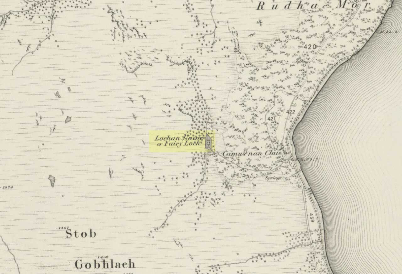
To get here, go down the A82 about four-and-a-half miles south of Tarbet (along the Loch Lomond road). Near a burn coming down the hill is an old house, long in ruin, and near the side of this is an old path – more for deer than city-folk. Go up through the wooded hillside for about a half-mile (amble the trek and make it a nice hour’s walk to get into the place). I’d take the stream itself, as you get more into the nature of the place once you get up the slope: there’s more to see, feel and a healthy water supply en route.
Folklore
This is more of a ‘holy loch’ than a holy well — for obvious reasons. Although it’s not much bigger than a large pond, it is little-known, but has long had the tradition of being an abode of the sith, or faerie-folk. There is, of course, a tendency to find prehistoric remains where the sith have their repute, but there seems little on official records nearby.
Tradition tells that the loch was actually formed in ancient times by locals damming the burn for water supply. Another tells the same in order that a mill could be fed with constant water – though no mill can be found. If this latter tradition is true however, the fairy creature here could have been a brownie – though they are generally more a lowland elemental. One of the reasons the place has been named after the little people is that when certain light falls on it, at the right time of day and year, green triangular shapes emerge from the water formed by deposits hidden beneath the surface (hence the original Gaelic name, Lochan Uaine, or the Green Loch).
Local historian Norman Douglas echoed the folktale described many years earlier by the great John Gregorson Campbell (1900), telling that,
“another story is that the local people would deposit their sheeps’ fleeces in the Fairy Loch overnight, wish for them to be dyed a certain colour, and overnight the fairies would carry out their wish.”
References:
Campbell, John G., Superstitions of the Highlands and Islands of Scotland, James MacLehose: Glasgow 1900.
In this region so full of old tombs and prehistoric remains, we find this little-known sacred well, long since known as a place of curious sprites and strange lore. Elizabeth Wright (1913) said of the place,
“It is said that the fairies were wont of old to wash their clothes in Claymore Well, and mangle them with the bittle and pin. The bittle is a heavy wooden battledore; the pin is the roller; the linen is wound round the latter, and then reolled backwards and forwards on the table by pressure on the battledore. The strokes of the bittles on fairy washing-nights could be heard a mile away.”
A most curious tale…
References:
Wright, Elizabeth Mary, Rustic Speech and Folk-lore, Oxford University Press 1913.
Pretty easy really. From the town centre, head up the B6143 Oakworth Road for barely 100 yards then turn right up the long steep West Lane. Just keep going. Near the very top turn sharp right onto Shann Lane. And there, on the left-hand side of the road, right next to the solitary old-looking house just 100 yards along, is our little well! (if you end up with fields either side of you, breaking into hills, you’ve gone too far)
Archaeology & History
Jennet’s Well, Black Hill, Keighley (middle of the picture, next to house)
The history of this site is very scant. It was written about by local historian William Keighley (1858) as a holy well dedicated to an obscure saint, St. Jennet, although early place-name evidences don’t tell as much. Some have even suggested that the same ‘Jennet’ was the tutelary saint of Keighley and district itself. Local historian Ian Dewhirst (1974), writing about the town’s local water supply, thought that “water from a spring ‘a mile to the west’ above the town…was conveyed by stone troughs through the chief street for the convenience of house-holders,” was probably Jennet’s Well.
Folklore
Described by Will Keighley (1858) as having “great healing abilities,” its specifics were undefined. And when the great Yorkshire writer Harry Speight (1898) came here forty years later, he told of the site “having a great repute, though no one seems to know why.” Mr Keighley was of the opinion that Jennet’s Well may have been the christianized site which overcame the local people’s earlier preference of dedication at the True Well, more than a mile west of here, between the gorgeous hamlets of Newsholme and Goose Eye; but this would seem unlikely, if only by distance alone.
The name ‘Jennet’ itself initially seemed somewhat obscure. It is not recognised by the Catholic Church as a patron saint. The word could be a corruption of the personal name Jenny, perhaps being the name of a lady who once lived hereby. There’s also the possibility that the title may infer the well’s dedication to the bird – a not uncommon practice. And we also have the modern folklorists who could ascribe it to the fairy-folk, as Jennet and Jenny are common fairy names, and old wells have much lore linking the two. But as Michala Potts pointed out, bringing us back to Earth once again, a ‘jennet’ is an old dialect word for a mule. I rushed for my Yorkshire dialect works and, just as Mikki said, the old writer John Wilkinson (1924) told simply, ‘Jennet – a mule.’
References:
Dewhirst, Ian, A History of Keighley, Keighley Corporation 1974.
Keighley, William, Keighley, Past and Present, Arthur Hall: Keighley 1858.
Speight, Harry, Chronicles and Stories of Bingleyand District, Elliott Stock: London 1898.
Wilkinson, John H., Leeds Dialect Glossary and Lore, James Miles: Leeds 1924.
Pretty simple really. Go up the B6265 Skipton-Rylstone road for about 3 miles, past the Nettlehole Ridge woodland on your right. The next turn along to your right, up the track, is Scale House. Go past this until you get to Scale House Farm. The remains of the burial mound is in the field to your left, just before the farm. Knock on the door and ask!
Archaeology & History
This ‘tumulus’ (as it’s marked on the OS-map) was one of the many explored by the legendary reverend William Greenwell (1864) in the middle to latter-half of the 19th century. His description of the finds at Scale House were considerable; thankfully our old Yorkshire antiquarian Edmund Bogg (1904) shortened it and told us the following:
“The tumulus was 31 feet in diameter and about 7 feet high; it opened from the southeast; the soil immediately under the sod consisting of yellow clay to a considerable depth; then layers of blue clay… Exactly in the centre…at a depth of 7 feet, and on a level with the plane of the field, was found an oak coffin, formed out of a tree, split and hollowed-out, and placed due north and south, the head being placed to the south, as that as the larger part of the tree. After being exposed to the air for about 2 minutes, the bared coffin parted at the sides, and could not be moved except by detached pieces. The body had been wrapped in a cloth or shroud of texture resembling wool and coarsely-woven, of which there was a considerable quantity remaining; but the body itself was dissolved… The interment was considered to be that of an ancient Briton… The learned antiquary said it was the only instance (except the one at Gristhorpe, near Scarborough) where an interment in an oak tree hollowed out had a tumulus placed over it. It was more than 6 feet in length inside and about 7 feet 6 inches outside. The remains were carefully replaced and the mound restored to its former shape; a small leaden tablet being placed within, stating that it had been opened in AD 1864.”
Folklore
Jessica Lofthouse (1976) listed this as one of the places reputed to be an old fairy haunt, wherein “the folk of Scale House discovered a fairy kist or chest.”
References:
Bogg, Edmund, Higher Wharfeland, James Miles: Leeds 1904.
Greenwell, William, British Barrows, Clarendon Press: Oxford 1877.
Lofthouse, Jessica, North Country Folklore, Hale: London 1976.
Standing Stone (destroyed): OS Grid Reference – TM 052 809
Folklore
This slab of sandstone apparently used to stand upright in one of the fields of Oxfootstone Farm and on its surface is supposed to be the burnt impression of a cow’s hoof-print. Legend tells that there was a fairy cow which would come into the area when times of hardship occurred. During such periods she would freely give her milk to the people, but when the drought was over she stamped down on the stone upon which she stood, burning the imprint of her hoof onto it and magically vanished back from whence she came. A variation of the tale tells of a normal cow whose milk normally supplied the local villagers. But one night a drunken man (in another tale it is a witch) milked the cow dry through a sieve, until only blood came from her udders. At this point, the cow cried out in pain and kicked the stone so hard that she left the mark of her hoof-print on it.
Another tale tells that an ox got a large thorn stuck in its foot and rampaged through the local village, eventually stamping its hoof onto the stone so hard that it left the imprint of its foot here.
Now this might sound presumptious of me — but this tale has all the hallmarks of it being an old folk-remnant telling the origin of some cup-and-ring marked stone. We find a number of cup-and-rings with creation tales similar to this. Are there any local archaeologists or enthusiasts in Norfolk who might be able to locate any remains of this possible carved stone?
References:
Burgess, Michael W., The Standing Stones of Norfolk and Suffolk, ESNA 1: Lowestoft 1978.
Dutt, W.A., The Ancient Mark-Stones of East Anglia, Flood & Sons: Lowestoft, 1926.


")
")


")