In Pennick & Devereux’s (1989) early assessment of our enigmatic cursus monuments, he wrote the following brief notes of this particular site:
“The crop marks of another fragmentary cursus were found in Gloucestershire immediately north of Lechlade, to the west of the River Leach. The crop marks aligned northwest-southeast for 174 yards (160 metres) and were 160 feet (50 metres) wide. Only the square northwest end is known. Excavations were carried out in 1965 in advance of gravel workings. No finds were reported, but two out of three cuttings revealed a post-hole on the inside of the ditch.”
References:
Pennick, Nigel & Devereux, Paul, Lines on the Landscape, Hale: London 1989.
Various ways to get here (being in the middle of the moor n’ all). I s’ppose the best way is to go from Langbar village, up hill to The Old Pike giant cairn, then follow the footpath on about 100 yards before dropping down the slope to your right, south (NOT the other way!). You’ll notice some walling and an old path near the bottom of the slope SE from you – head in that direction, but before you get there, a coupla hundred yards before, stop and look around. Good luck!
Archaeology & History
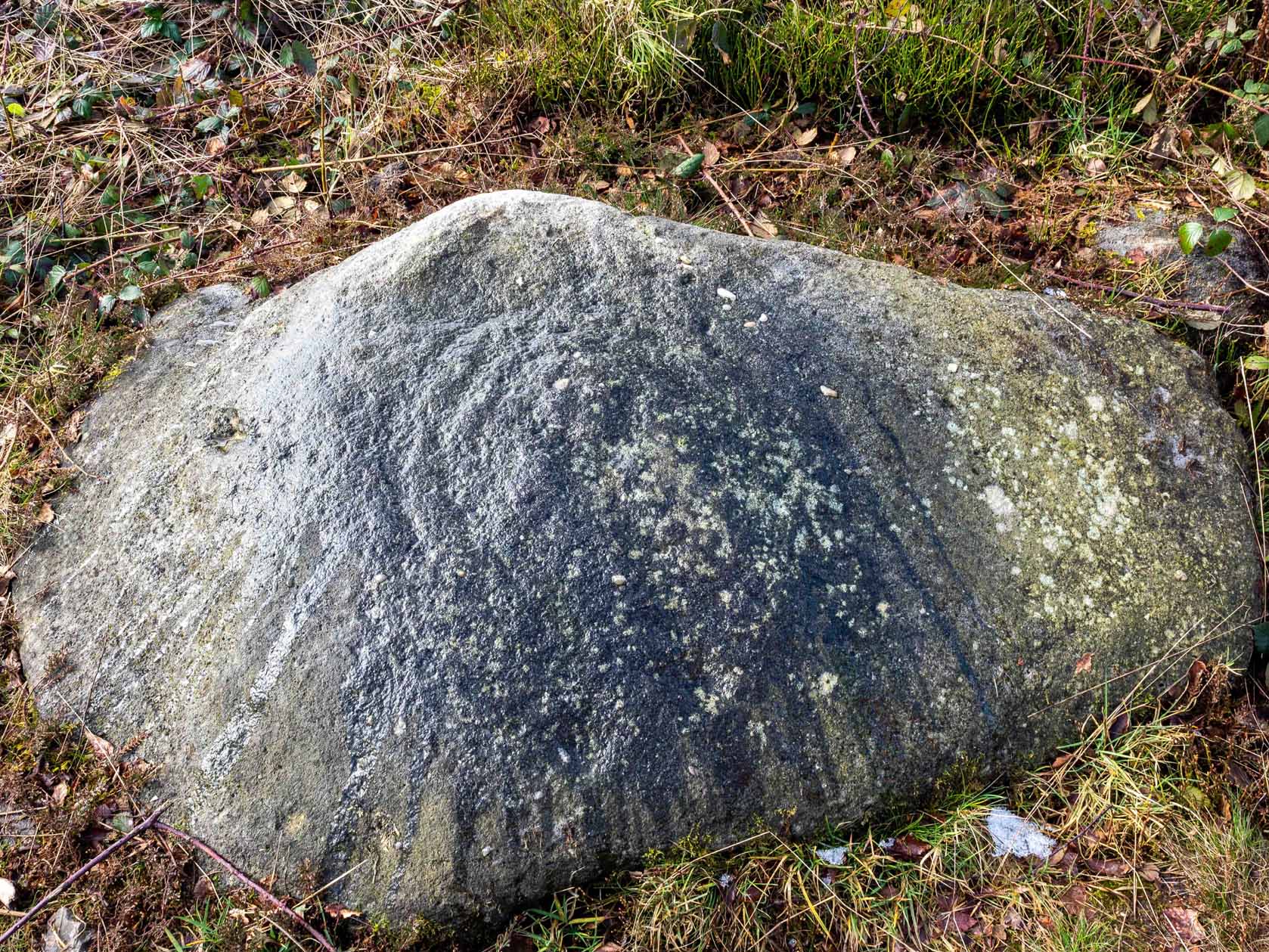
Found halfway up the southern slope beneath The Old Pike giant cairn, we find this large, flat earthfast stone, on which are the very faded remains of archetypal cup-and-ring motifs. At the top-end of the stone are slightly more pronounced cup-markings – seemingly more than is shown on the drawing, with the multiple-rings halfway along the stone. On the southeastern part of the stone, Richard Stroud found another previously unseen aspect of the carving, consisting of one large ring, with perhaps a line running out to the east. This can be seen in the water-highlighted photo.
Langbar Stone, with extra single ring not previously noted
If you visit this carving, try and get to the Middleton Moor CR-482 stone half-a-mile southwest – where I for one got the distinct impression that whoever carved that stone, also carved this one! Barmy p’raps — but if we don’t allow subjective interface here and there, we never learn a damn thing!
Listed as stone 459 in Boughey & Vickerman’s (2003) survey, they erroneously ascribe Eric Cowling to have found it in Rombald’s Way (1946), whereas the first mention of it appears to have been by Stuart Feather in 1966 (though Cowling does mention a ‘Langbar Stone’, but illustrates another one nearby).
References:
Boughey, Keith & Vickerman, E.A., Prehistoric Rock Art of the West Riding, WYAS 2003.
Cowling, Eric T., Rombald’s Way, William Walker: Otley 1946.
Feather, Stuart, ‘Mid-Wharfedale Cup-and-Ring Markings. No.41, Langbar Moor, Ilkley,’ in Bradford Cartwright Hall Archaeology Group Bulletin, 11, 1966.
From The Royalty hotel, walk along the footpath onto the Chevin itself, turning left then walk about 350 yards east, past the small copse of trees. Just north of the main path before the land slopes down you’ll find it. It’s carved on an earthfast rock about 6 feet long.
Archaeology & History
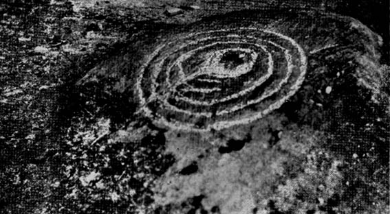
This is an excellent carving if you’re into cup-and-rings! Eric Cowling (1940) first described the stone* in an article for the Yorkshire Archaeology Society. Although it’s somewhat faded, when the stone’s wet and the sun’s low on the horizon, you can make out more rings than just the three which Boughey & Vickerman (2003) described in their survey.
Folklore
Knotties Stone (E.T. Cowling)
Although the Chevin itself has a tradition of ‘supposed’ heathen goings-on in bygone days, the carving has nothing specific said about it. Although one intriguing bit of info comes from the old Otley historian, Harold Walker (1974), who said that, “blocks of stone were sent from (the) Chevin to form the foundations of the Houses of Parliament”!
Those lying deviants probably smashed up a few bits of extra rock art when they did this — not that those sort of people give a shit about anything unless it’s about money.
References:
Boughey, Keith & Vickerman, E.A., Prehistoric Rock Art of the West Riding, WYAS 2003.
Cowling, E.T., ‘A Classification of West Yorkshire “Cup-and-Ring” Stones,’ in Archaeology Journal, 97, 1940.
Cowling, E.T., Rombald’s Way, William Walker: Otley 1946.
Hotham, John Paul, Halos and Horizons, Hotham Publishing: Leeds 2021.
Walker, Harold, This Little Town of Otley, Olicana: Otley 1974.
* Graeme Chappell tells me that this carving was named after Cowling’s nickname, Knotty!
From Keighley town centre, take the main road to Oakworth (B6143) and you’ll see it right by the main roadside, about a mile up on the left-hand side upon a small grassy area in Exley Head, just past the turning up to Wheathead.
Archaeology & History
The upright stone monolith, or cross, which would once have stood here has long since disappeared. All we are left with today is the large cross-base by the roadside: roughly squared, with a large hollow at the centre in which the upright stone cross originally stood erect! In the past, a number of archaeologists and historians have speculated that the Exley Head Cross dated from as early as the 9th up till the 15th century. We may never find out for certain, though it’s likely a post-Domesday medieval relic. It’s position at the roadside gives it the category of being a ‘Wayside Cross’ and it is likely one in a deliberate sequence that were placed along the ancient route from above Keighley, to Oakworth and over the border into Lancashire, near Wycoller and beyond.
Close-up of Exley Head Cross base
Quite why it was placed here is something we may never know: though it is close by an old crossroads and could have replaced an earlier heathen site, but I’ve found no records to indicate this. Its position in the landscape would also have been more impressive before the housing was here, previously giving a wide open view of the Aire Valley below. I’d be grateful for any more info on this site.
References:
Brigg, J.J. & Villy, F., “Three Ancient Crosses near Keighley,” in Bradford Antiquary, New Series 6, 1921.
The easiest way to get here is via Cowling – though you can approach the place via moorland roads from Sutton-in-Craven, Oakworth and Keighley, but Cowling’s the closest place (so we’ll take it from there). Turn east off the A6068 up Old Lane at the Ickornshaw side of town and go up the steep and winding road until you hit the moors. Just as the road levels out with walling on either side of the road, there’s some rough ground to your left. You can park here. You’ll blatantly see our Hitching Stone on the moorland a few hundred yards above you on the other side of the road. Walk up the usually boggy footpath straight to it!
Archaeology & History
For me, this is a superb place! Each time I come here the place becomes even more and more attractive — it’s like it’s calling me with greater strength with each visit. But that aside…
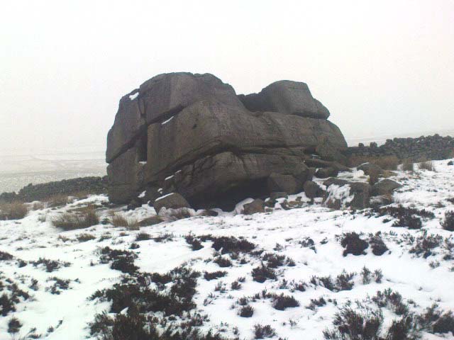
Supposedly the largest single boulder in Yorkshire, it possesses several legends, aligns with the sacred Pendle Hill in Lancashire, is an omphalos (centre of the universe spot) and has other good points too! My first visit here was near the end of the Great Drought of 1995. All of the streams and springs had dried up on the moors but, on the very top of this huge rock, measuring at least 8 feet by 4 feet across (and 3 feet deep) was a large pool of water, not unlike a bath, in which a couple of you could easily bathe (and do more besides, if the fancy takes you!). It was surreal! Water-boatmen and other insects were living in this curious pool on top of the rock. Yet all other water supplies for miles around had long since dried-up. It didn’t really seem to make sense.
Crystalline tunnel in the Hitching Stone
On the west-facing side of the boulder, about 8 feet up, is a curious deep recess known as the Druid’s or Priest’s Chair, into which initiates were sat (facing Pendle Hill, down which it seems the equinox sun “rolls”) and is believed, said Harry Speight, “to have some connection with Druidical worship, to which tradition assigns a place on these moors.” If you climb up and inside the Priest’s Chair section you’ll notice a curious “tunnel” that runs down through the boulder, about 12 feet long, emerging near the northern base of the rock and out onto the moor itself. This curious tunnel through the rock is due to the softer rock of a fossilised tree (Lepidodendron) crumbling away — and not, as Will Keighley (1858) believed, “the mould or matrix of a great fish.” When we visited the stone the other day in the snow, we noticed how the inner surface of this tunnel was shimmering throughout its length as if coated in a beautiful crystalline lattice (you can sort-of make this out in the image here, where the numerous bright spots on the photo are where the rock was lit up). Twas gorgeous!
The Hitching Stone, looking north
The boulder lies at the meeting of five boundaries, and was the starting point for horse-racing event until the end of the 19th century. A short distance away “are two smaller stones, the one on the east called ‘Kidstone’, the other ‘Navaxstone’, which stands at the terminus of the race-course.” (Keighley 1858) Lammas fairs were also held here, though were stopped in 1870.
The cup-marked Winter Hill Stone a few hundred yards to the northeast, which I previously thought aligned with this site around winter solstice, but which happens to be a few degrees of arc off-line, would have indicated a very early mythic relationship, but this thought may now have to be put to bed. I’ve not checked whether the winter solstice alignment shown in the photo below (with the Hitching Stone being shown on the near-horizon as the sun rose on winter solstice, 2010, from Winter Hill Stone) would have been closer in neolithic times or not. Summat to check out sometime in the future maybe…
This aside, there is little doubt that this was an important sacred site to our ancestors.
Folklore
Winter Solstice sunrise, 2010 (from Winter Hill Stone)
Legend has it that the Hitching Stone used to sit on Ilkley Moor. But it was outside the rocky house of a great witch who, fed up by the constant intrusion the boulder made to her life, tried all sorts of ways to move it, but without success. So one day, using magick, she stuck her wand (or broomstick) into the very rock itself and threw it several miles from one side of the valley to the other until it landed where it still sits, on Keighley Moor.
A variation on the same tale tells that she pushed it up the hill from the Aire valley bottom. The “hole” running through the stone is supposed to be where our old witch shoved her broomstick!
The faded remains of this old burial mound can vaguely be seen just off the right-hand (east) side of the B1248, across the road from the track which leads down to Burdale North Wold farmhouse, between Fimber and Wharram-le-Street.
Archaeology & History
Known as Towthorpe Barrow No.1 in the Mortimer survey (1905), there are a number of prehistoric tombs and other remains close to this site (which will be described on TNA as time goes by). Some of you might think the lengthy description here a little unworthy, but I believe the extensive archaeological notes on this site by an archaeological legend, J.R. Mortimer, is a good indicator of the dedication and interest to which he gave each and every tomb that he opened (this’ll be the first of many). His slightly edited account told:
“This mound is situated near the centre of the (Towthorpe) group, close to High Towthorpe. Here the green lane…is crossed by the high road from Malton (B1248), through Wharram-le-Street… Part of this road, for some distance south and north of the barrow, is called ‘High Street’ by the old inhabitants of the neighbourhood…
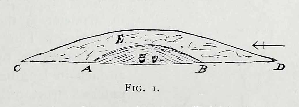
“On 4 May, 1863, the writer, with the assistance of R. Mortimer and two workmen, commenced to open this mound. It was the first British barrow he had the pleasure of examining. A trench 10 feet wide was cut across its centre from the northern to the southern margin…
“The upper portion E, to a depth of 16 inches, consisted chiefly of the surface soil of the neighbourhood, the bottom part of which was reddened as if by the action of fire. Close below this was a stratum of wood and ashes and other dark matter, 2-3 inches in thickness; and then a lenticular bed of tough drab-coloured clay, 29 feet in diameter, and 12-14 inches thick in the centre, gradually thinning towards the circumference. The upper part of this bed of clay, which was in contact with the stratum of wood ashes, was reddened by fire; its under surface had a similar appearance and rested upon what seemed to be a second stratum of burnt and decayed matter, 2-3 inches in thickness, similar to that already described. The clay forming this lenticular bed contained numerous small fragments of grey flint, characteristic of the chalk of the neighbourhood. It must have been obtained from one of the valley bottoms (either Burdale, Wharram-le-Street or Duggleby), in which are exposures of the Kimeridge clay. In these places, angular pieces of flint and chalk crumble from the hillside, and mix with the clay, imparting a greyish colour to it. This is especially the case at Burdale, where there is a fine spring at the base of the chalk, and a small pond resting on the Kimeridge; and it is probably from this place that most of the clay for the construction of this barrow was obtained. It is not easy to explain the method by which the clay was transported, but several tons had evidently been used in this case. Many other instances in which material from a distance has been used in the erection of the barrows of this neighbourhood are recorded in (the Yorkshire Wolds).
“In the centre of the mound, at the base of the lenticular bed of clay and below the ashes (which probably represent the residue of a funeral pyre) stood two food vases, close together, and near to these, decayed bones (the remains of a human body) and a chipped flint. The smaller and more ornamented vase was situated to the south of its fellow. It measures 4.5 inches in neight, 5.5. inches in diameter at the top, and about the same across the shoulders. The ornamentation had been impressed on the plastic clay by a thin square-ended tool, about half-an-inch in length, which showed in the impression of a fine notched structure, and was equally divided into ten ridges about the size of the indentations on the milled edge of a shilling, and almost as truly cut. In the lower groove which runs round the vase are four pierced projections.
“The other vase is about 5 inches high and about 6 inches in diameter at the top and across the shoulders. Three encircling lines of short vertical cuts, rudely and apparently hastily made, previous to baking the vase, represent its entire ornamentation.
“During the excavation we collected from the material of the mound a dozen hand-struck flint flakes of various sizes, and a small splinter from the cutting-edge of a green-stone celt.”
Mr Mortimer returned to do further excavations here on Christmas Eve and Christmas Day in 1865, with the hope of finding more — but apart from a finely-cut knife made of black flint, nothing else was located. This was the first of Mortimer’s hundreds of diggings into the tombs and dykes of East and North Yorkshire.
References:
Marsden, Barry M., The Early Barrow Diggers, Tempus: Stroud 1999.
Mortimer, J.R., Forty Years Researches in British and Saxon Burial Mounds of East Yorkshire, A. Brown: London 1905.
Loadsa ways to get to this little outcrop, which the Boughey & Vickerman survey (2003) says comprises of five different carvings (CRs 33-37). I’m not so sure misself. When Stuart Feather first found these in the 1950s, he only thought three stones were carved, which I think is the more accurate.
Most folk would probably prefer to walk down the slope from Holden Gate down the footpath past Jaytail Farm, then dropping down to the very bottom of the fields (south) where you’ll see a small knoll with a cluster of rocks just in front of the tree-line. But I wandered up thru the ‘Private’ (ahem!) woodland, wet-thru in the pouring rain, and clambered over the wall right to the very spot (the old dowser’s ‘seek-and-find-rock-art’ nose worked again!).
Archaeology & History
High Carr Cup-Marked Stone – from Hedge’s Carved Rocks on Rombald’s Moor
Listed in John Hedge’s (1986) survey as carvings 1-5, I’d say there’s one “definite” carving here, but the others – comprising simply of cups – are a little dubious. The main carving has at least six definite cup-markings, found on the rock at the highest point of the knoll at the bottom of the field. The drawing in Hedge’s survey shows as many as 12 cups on this stone, but I’m not totally convinced. Another stone right next to the main one has, perhaps, a cup-marking or two on it – but again, these may be natural.
Of the other alleged carvings, it was difficult to work out as they were literally covered in tons of cow-shit. It seems this rock-outcrop is the local bovine toilet! A lovely secluded place though, with plenty of wildlife to see. Next stop from here: the great Holden waterfalls!
References:
Boughey, K. & Vickerman, E.A., Prehistoric Rock Art of the West Riding, WYMCC: Wakefield 2003.
Feather, S., ‘Three Bronze Age Rock Carvings near Keighley,’ in CHAGB 4:3, 1959.
Hedges, John D., The Carved Rocks on Rombald’s Moor, WYMCC: Wakefield 1986.
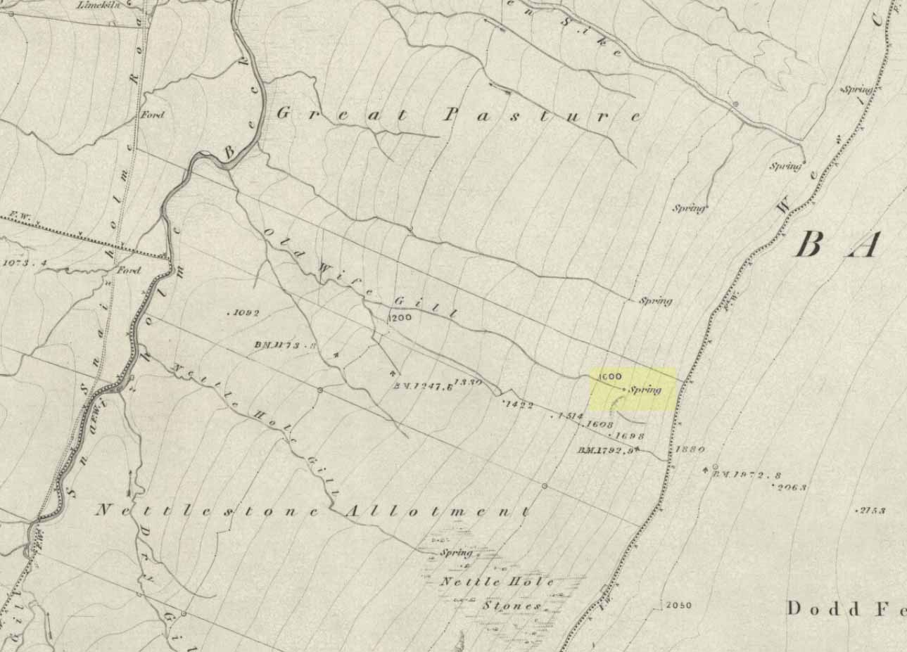
The ‘Spring’ atop of Old Wifes Gill, on 1853 OS-map
From Hawes, take the B6255 road west-ish to Ribblehead, but only for 1km, where there’s the Cam Road track on your left. Walk on here, and keep going till you’re looking down the valley past the very last house (those of you who wanna take the Pennine Way from Hawes will end up in the same place). It’s one of the springs down the steep slope on your right! (check the attached link to the OS-map to work out which one you’re heading for)
Archaeology & History
Apart from a singular mention in place-name records, I have found no historical information (yet!) about this old water supply. It was one of the great sites of the cailleach in our Yorkshire hills: a truly ancient and heathen place, all but forgotten and lost in the mythic landscape of our past. And it’s a bittova dodgy spot getting right up to her down the rather steep hilly slope — but it’s truly well worth the trek!
The Old Wife’s Spring
When I first visited this place, we took off from Cam Fell’s western side and ambled up the tops until the land gave us the beauty of Snaizeholme valley, which had us stopping, dreaming and wanting more as we sought to find this forgotten well. Most of you would probably come from the easier side of Hawes and walk along the path on the southern-side of the valley, or p’raps even wander up Snaizeholme valley itself – but I’d recommend a walk along the tops. Tis much much better!
If you’ve got the 1:25,000-scale OS-map, you’ll see the ‘Old Wife’s Gill’ running down the hillside. Get over the wall by the track-side and stagger down the steep slope. You’ll pass a small spring about 70 yards down – but this aint the one (though I think originally the Old Wife came from much further up Dodd Fell itself). You’ve got another 75 yards to go down before you get to the main spring – but if you’re old and fragile, unfit or fat, you’ll struggle like hell here!
The waters emerge from this very steep slope, surrounded by plenty of thorns and thistles, on a part of the hill where the land itself is slowly coming away. After a long dry-spell no doubt, this might be a little more secure; but when we came here She’d been raining on-and-off like hell and the waters were a-plenty. It’s difficult to actually locate the exact spot where the water first appears – but like I said, it seems to have, long ago, come from much further up the hill. As the photos show, the water’s nice n’ clear, good-tasting, and then continues along its downward stream – known as the Old Wife’s Gill – until hitting the small river at the valley bottom.
The Old Wife’s Spring from below
The other site in this valley which assures us of the cailleach’s validity comes from the place-name a few hundred yards further up the valley, seemingly giving source to the valley river herself: a Lady Spring or well, whose form once emerged close to the gate of the Cold Well close by. The third part of the cailleach’s form – the maiden or virginal – has been lost as far as local myth and literary records go. But I’ve gotta come here a few more times to get an idea as to where this ‘lost’ water-source originally appeared. A number of streams run off the hills here into the curiously-named Snaizeholme valley (which etymologists assign to nowt more than a “place where twigs are” – which seems nonsensical), and as there’s been very little by way of human habitation screwing the land up, there’s a damn good chance we’ll find and recover the mythic history of the landscape here after a few more treks and dreams…
Other sites of similar mythic relevance which need checking include Carlow Hill (SD 770 858)at Stonehouse, Dentdale; and the great valley of Carlin Gill on the North Yorkshire/Cumbria border (SD 634 993 – Gambles 1995:39).
Take the road from Shipley to Guiseley, the A6038, past the turn-off to Esholt, until you get to the top of what’s locally known as Hollins Hill. There’s a small farm-track to your leftand in the woodland here you’ll find the rocky outcrop.
Archaeology & History
Nothing has been written about this spot, but in this large wind-and-water worn rock outcrop, with its small cave, on the top part of the rock are several faint cup-markings.
Folklore
Legend tells that a man on horseback jumped from the top of here and landed safely at Low Hall, Yeadon, 2500 yards away to the east. (probably some sort of solar lore)
References:
Gray, Johnnie, Through Airedale, from Goole to Malham, 1891.
About a metre tall and found standing near the bottom of one of the fields diagonally across from the old farmhouse of Laverock Hall, here’s another old stone which may not have a prehistoric provenance. It is seemingly unknown by all but local people and would seem to be an old rubbing post for cattle — albeit a small one! There seems to be no written accounts of this stone; though until all of the local field-name maps have been checked, we can’t discount the possibility that this is the “standing stone” described in early place-name records that was mentioned by A.H. Smith in 1963.
References:
Bennett, Paul, The Old Stones of Elmet, Capall Bann: Milverton 2001.
Smith, A.H., The Place-Names of the West Riding of Yorkshire – volume 6, Cambridge University Press 1963.