To get here, follow the same directions as you would to reach the curious Green Plain settlement; but just before you reach that, you’ll notice this rather large boulder known as the Eagle Stone right in front of you next to the ever-decreasing stream. Wander down and give it a fondle — you can’t really miss it!
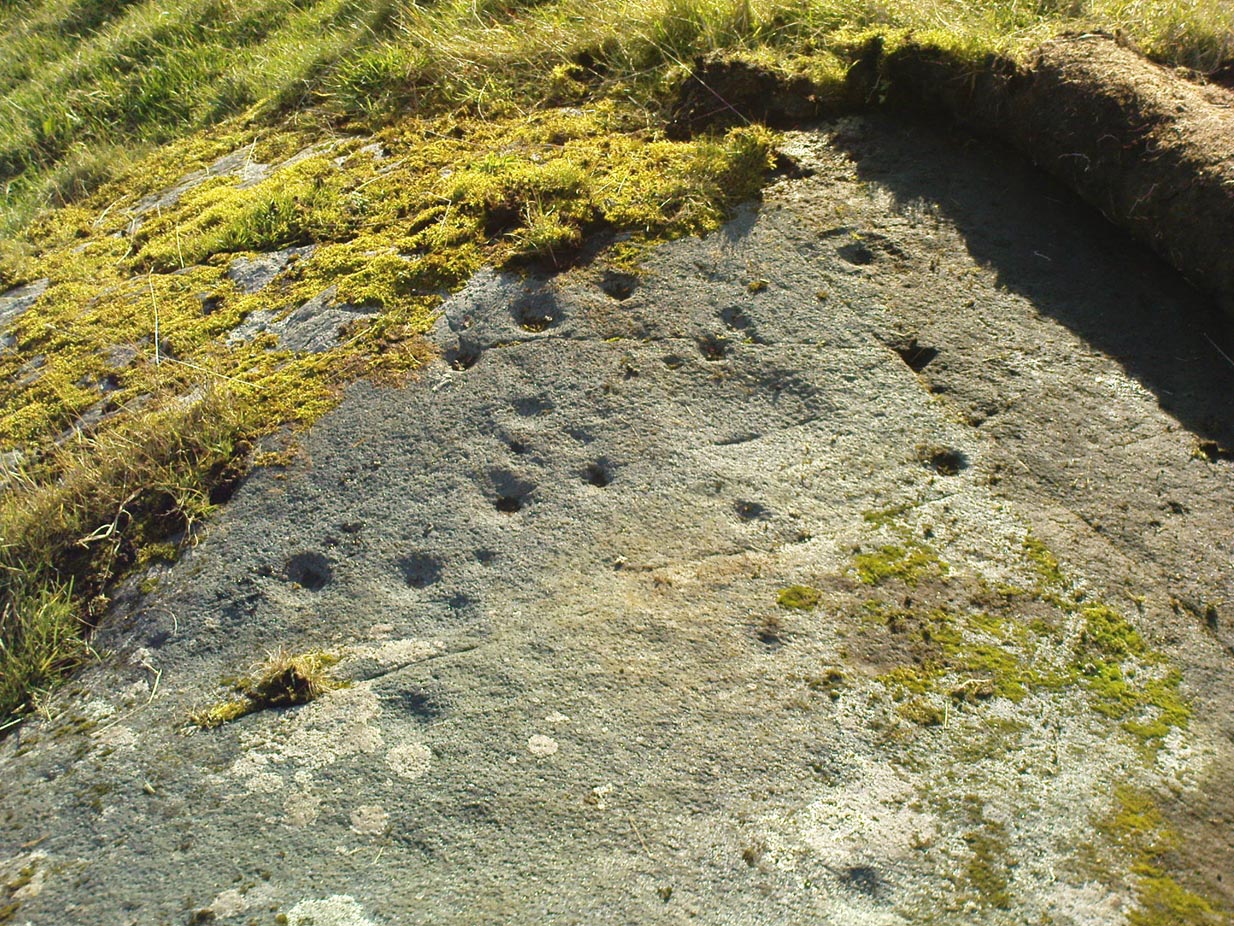
Archaeology & History
Cupmarks on top (image by Graeme Chappell)
Curiously not included in Boughey & Vickerman’s rock-art survey (2003), this large boulder stands just below the ancient ford which crosses Sun Bank Gill and is pitted with a number of cup-marks on its top (though not the 38 we counted when Graeme Chappell and I in the early 1990s), plus a large “bowl”, not unlike the Wart Well on top of Almscliffe Crags and other such sites. Although some of the cups seem natural, others are artificial — as even an English Heritage rock art student could tell you! A small cluster of ‘cups’ are on top of the stone, but a number of them have been etched onto the sloping southern face; a curved line running across the rock-face towards these cups may be natural.
The straight track above you was known as Watling Street in bygone years and was the old Roman road running between Ilkley and Aldborough.
Pretty easy to find – assuming it aint at the height of summer and the crops are approaching maturity, otherwise you’re only gonna see its head! But, this aside: from Aberfeldy, take the B846 road over the river bridge that bends you along the valley of the River Tay towards Appin of Dull. After some 2 miles you’ll pass the right-turn up to Dull. Go past this for another coupla hundred yards or so, watching out for the left-turn down towards the farmhouse of Carse and park up where you can (if you go past it, there’s the second turn up to Dull, again on your right, where you can turn round). As you walk down the track towards Carse Farm, watch out on your right in the field below Carse I, in the second field down. You can’t really miss it. (and the farmer here is spot on if you ask to check the stone – as long as the crops aint growing)
Archaeology & History
Although all that’s left of what is thought to have been a once proud stone circle is the singular upright standing stone in the middle of the field. Aubrey Burl (1988) thought that this was one of the typical “four poster”rings that scatter our isles, but I’m not so sure misself. There were other stones associated with the site when Burl described it, but these were covered over in our visit here a few months back — which is a pity, as two of the stones are reported as possessing cup-markings (if/when we revisit the site, I’ll try get some images of the respective stones and add them on TNA as individual carved stones). The site gives the distinct impression of it having a funerary character of some sort and not a true stone circle — and this was strongly suggested by some of the finds inside the “ring”, described below.
Fred Cole’s old drawingAubrey Burl’s groundplan
Both this and its associated “circle” a few hundred yards away — known as Carse Farm north — sit on a flat level of ground in the Tay valley, with rounded hills all most sides. This landscape setting was obviously of some importance to the people who put the circle here in the first place but, not living in the region, it’s difficult to assess the mythic relevance some of the hills will have obviously played in the siting of these stones.
In bygone days, it was reported that the much of the site was ploughed away due to agricultural excesses, so there was obviously much more to it in earlier centuries. Describing the solitary stone that’s left today, along with the earlier excavation results, Mr Burl (1988) wrote:
“The stone still standing, of quartziferous schist, is 6ft 3in (1.9m) high. Its longer faces are aligned NW-SE. 32ft 6in (9.9m) to its SW is a large prostate block, sub-elliptical and about 8ft long and 4ft 3in wide (2.4 x 1.3m). It has probably fallen outwards. (my italics, PB) If so, when standing near the top of its inner face were four cupmarks in a cross pattern.
“About 32ft ((9.8m) to its NW is a fallen and enormous schist slab, 11ft long and 5ft wide (3.4 x 1.5m). It also appears to have toppled outwards. Near the bottom of its inner face are two cupmarks. The situation of these three stones suggests that they once stood at the corners of a rectangle some 32ft (9.8m) square, the pillars of a huge four-poster nearly six-times the national average and with an internal area ten times bigger than the small 4-poster (Carse Farm north, PB) just to its north.
“Excavation in 1964 found the socket from which the great prostrate slab had been dragged… Cash (1911) had noted the presence of a small stone inside the ring about 20ft (6.1m) west of the standing stone. It proved to be 4ft (1.2m) square with a carefull-dressed face. It had been set upright, standing about 1ft 4in (41cm) above the ground. Three sides of the worked face ‘had been carefully chiselled away to a straight edge.’ It may have been a slab lining the inner central space of a destroyed ring-cairn. Burnt bone was found near it. There was also a rounded river pebble with a worked hollow on one side…”
Folklore
Carse Farm stone
Stewart (1964) described the site as having been “christianized” not long ago, by having the northernmost standing stone in the ring removed. This is intriguing inasmuch as “north” is the place of greatest symbolic darkness in the pre-christian mythos, and represented death and illumination in magickal terms. North was also the point taken by witches and shamans in their excursions into Underworlds, usually via the North Star, which tethered the Earth to the heavens (see Godwin’s Arktos [1993], and Grant, The Magical Revival [1973]) In the removal of this northern stone for the reasons given, that implies some magickal events or folklore were in evidence here when this took place. Anyone got any further information along these lines, or has it long since been subsumed?
References:
Burl, Aubrey, Four Posters: Bronze Age Stone Circles of Western Europe, BAR 195: Oxford 1988.
Follow the directions to reach the Herder’s Cross, not far away. Standing on the Herder’s Cross stone, look across the fields to the north (away from the farmhouse on the hill below) and you’ll see a nice-looking stream a coupla hundred yards ahead of you. Crossing this stream you see the large boulder, which you can see clearly if you’re stood on the Herder’s Cross. That’s where you’re heading!
Archaeology & History
A curious entry inasmuch as I’ve found no other references to the place. It’s an obvious cross-base, albeit very worn, cut onto the top of this large boulder, as you can see in the photo. What may be a singular cup-marking (if you’re a New-ager, or work for English Heritage that is!) is on the western side of the rock — but without additional markings on the rock, this has gotta be questionable.
Dodgy cup-marking on top!Shallow cross-base
The cut ‘square’ measures eight-inches both sides, but it seems that the cutting on the north-eastern sides of the base was never finished. The depth of the cross-base is also very shallow, only an inch deep. There seems to be a distinct possibility that this particular stone was initially chosen as a wayside cross marker, then for some reason perhaps moved to the position of the Herder’s Cross in the fields 420 yards (383m) to the south of here.
Clifford Byrne (1974) suggested that the pathway hereby was an ancient routeway that led towards the Emmot Holy Well, three-quarters of a half-mile down the hillside from here. Any further info or thoughts on this side would be most welcome.
References:
Byrne, Clifford, A Survey of the Wayside Crosses in North East Lancashire, unpublished manuscript, 1974.
An unusual cup-marked stone — not because it’s found in the grounds of the chapel, but because the design appears carved on a flat slab, as if it might have been used as a grave cover or perhaps stood upright in times gone by. First described in Rob Graham’s Carved Stones (1895) in the days when a few more cup-markings were visible; nearly a hundred years on it was included in the Royal Commission’s (1984) report as “a prone slab measuring 1.7m by 0.98m and 0.15m in greatest thickness; its upper surface bears at least nineteen plain cups up to 110cm in diameter and 40mm in depth. In addition, wear has caused a large deep cup, 180mm in diameter and 80mm deep, to penetrate the stone, and there is another circular, vertical-sided, perforation measuring 70mm in average diameter and expanding to 90mm at the upper surface on the stone” — meaning there’s a hole that’s been worn through the rock itself. This hole would seem to be accounted for by the folklore tradition of the site.
Folklore
It was reported by R.W.B. Morris (1969) that the cups here were “said to have been enlarged by a former ‘wishing’ rite” — a tradition echoed at another carving not far away where a pestle was used on the cup-marks and rotated 3 times, then a wish was made and an offering left to aid the wish. Morris suggests this could have been a faint relic of solar worship.
References:
Graham, Robert C., The Carved Stones of Islay, James Maclehose & Son: Glasgow 1895.
Cup-Marked Stone: OS Grid Reference – SO 1576 5858
Also Known as:
Llanerch Stone
NPRN – 306082
Archaeology & History
Llanerch cup-marked stone (after Watkins, 1932)
A small and simple cup-marked boulder, hidden away in the Welsh hills, all-but unknown even to cup-and-ring fanatics! It’s nowt special to look at, reminding me somewhat of the numerous cup-marked rocks that scatter the edges of Baildon Hill in Yorkshire. Found close to a number of other prehistoric sites, the stone isn’t in its original position so we’re unable to tell whether it was associated with any tombs (as is probable). The carving consists of around 32 cup-marks, with some 18 of them visible on its upper face. It’s likely that there were more cups on it originally, for when it was first found (as shown in the photo here, taken soon after being discovered) one side of the stone had been split away, but the other section was nowhere to be seen. Alfred Watkins (1932) told how it was first discovered:
“Following a visit by the Woolhope Club in 1928 to that fine mound on Radnor Forest—Cruger Castle…a fellow member (Mr. Walter Pritchard), working on alignments, discovered a fine cup-marked stone, at Llanerch Farm, a little south of the mound. I visited and photographed the stone the same year, and took a rubbing of the cup-marks on it, also taking as careful a bearing as possible, and marking it on the paper while on the stone.”
Its isolation is a little unusual, but there are likely to be other carvings scattering the nearby hills and valleys awaiting discovery by enthusiastic explorers.
Folklore
The great ley-hunter himself, Alfred Watkins (1932) — following in the footsteps of some of his contemporaries it’s gotta be said — used this carving to add fuel to his notion of leys and aligned sites, thinking that the cup-markings on the stone were representative of such things, etched thousands of years back to be used by other travellers. Can’t see it misself — but then I did spend a few years looking at the potential relevance cup-and-rings had with alignment features when I was a boy, ruining many a-map and finding they had no relationship whatsoever to such things! But it seems that Mr Watkins was still going through the exploratory phase at the time, because, after taking a rubbing of the stone he told:
“I also (as soon as I got home) tested for alignments, and inked in those of four cups which I found, as I considered lines of three to be of no value as proof. I could not at that time see any tangible proof of anything, and put it down to this (broken) stone having probably been moved. The reproduction I give is of this crude rubbing exactly as I finished it (outlining then the rather indefinite edges of the cups) in 1928.”
References:
Sharkey, John, The Meeting of the Tracks: Rock Art in Ancient Wales, Gwasg Carreg Gwalch: Llanrwst 2004.
Watkins, Alfred, Archaic Tracks round Cambridge, Simpkin Marshall: London 1932.
From Hebden Bridge, take the Heptonstall road and go past the legendary Slack Bottom (no lies!), until a few hundred yards further on at Slack Top, take the Widdop road on the right. Amble the long and winding road for a mile – mebbe a bit more – until the valley on your right runs out of trees! (on the OS-map this is called Hebden Dale, but it’s generally known as Hardcastle Crags [after the name of the rock outcrop halfway up]). Just about here there’s a track to your left, by the rather desolate bus-stop! If you hit the wibbly hair-pin bend by the Blake Dean scout-hut, you’ve gone too far. Walk along the track for a coupla hundred yards and take the first opportunity you have to cross the deep dike on your immediate left. Then just walk along the edge of the stream itself until you reach the large rocks another few hundred yards along.
Archaeology & History
As Richard Stroud’s photo above shows, this is a beautiful spot — when the weather is good anyway! Much of the landscape around you is scattered with occult history and folklore: boggarts, witches, corpse routes, spirit animals, old stone crosses, standing stones and more! A damn good day out can be had in this area by any enthusiastic antiquarian or enquiring heathen.
Cups and faint rings
The carving we have here is an almost typical cup-and-ring stone, but it’s pretty isolated with no other ringed companions anywhere on these hills. It was first described in David Shepherd’s (2003) survey of prehistoric remains of the region — although I was initially a little cautious about the veracity of David’s findings, as some cup-marked stones in his survey are probably natural and some “standing stones” he cites nearby are simply natural earthfast rocks. But this particular carving seems man-made with large faint rings encircling at least one of the cup-marks, as you can see in Richard Stroud’s photo here. In Mr Shepherd’s survey, he said of this site:
“A prominent double boulder. On the top surface are two eroded cup marks by the south edge and one by the north edge. Two eroded cup marks with rings are on the northwest segment.”
References:
Shepherd, David, “Prehistoric Activity in the Central South Pennines,” in Transactions of the Halifax Antiquarian Society, new series, volume 11, 2003.
Acknowledgements: With thanks to Richard Stroud for use of his photos in this site profile.
This small, simple cup-marked stone is found close to the small Mudbeck stone circle. Consisting of just four shallow cup-marks almost running in an arc formation, the site was first discovered by Tim Laurie in the late 1990s. I’ve not been to this place so rely on the photos kindly sent me by Richard Stroud, and the description of the place by Paul Brown (2008), where he told:
Close-up of 4 cups (courtesy Richard Stroud)Mudbeck 2 in the landscape (courtesy Richard Stroud)
“On the crest of a ridge some 50m south-west of Mudbeck a scatter of small boulders form an indistinct ring-shape and a cup-marked boulder with four cups was discovered here by Tim Laurie. It was suggested that the stone scatter represented the possible remains of a cairn that had at some point in its past been stripped of its stone for the construction of walling and sheepfolds in the area. ”
The only other cup-mark close by is one alleged to be on one of the small uprights in the Mudbeck circle (known as MUD S1 in Brown’s survey) – though I have to say that the “carving” is somewhat dubious to me.
References:
Brown, Paul and Barbara, Prehistoric Rock Art in the Northern Dales, Tempus: Stroud 2008.
Acknowledgements: Many thanks to Richard Stroud for use of the photos in this site profile.
From Silsden, take the moorland road up to Brunthwaite (ask a local if you’re in doubt). As you get near the top of the moorland road, take the right turn (east) on the track past the Doubler Stones, until you reach the last cottage before the woodland called Black Pots. Go onto the moorland behind the cottage, walking north, crossing the stream and you’ll see a large boulder stuck on its own close by. That’s it!
Archaeology & History
Stuart Feather’s 1964 image
On another wander on these moors t’other day, we ventured to the Doubler Stones and whilst there I had a vague recollection of another decent-looking carving west of them, just above the hidden house at Black Pots, when I was a teenager. When I got home I rummaged through some of my old notebooks and found the drawing I made of it all those years ago. Tis a decent carving consisting of 3 distinct cups encircled, though not completely, in an elongated arc. A cup-and-ring is just above this, and Boughey & Vickerman (2003) highlight another couple of cups which I didn’t manage to see when I was there as a kid. Nor for that matter did Stuart Feather, who was the first person to write about it in the Cartwright Hall Archaeology Group Bulletin in 1964. Itis a good carving in a good spot, with excellent views to the south and west.
References:
Boughey, Keith & Vickerman, E.A., Prehistoric Rock Art of the West Riding, WYAS: Leeds 2003.
Feather, Stuart, “Mid-Wharfedale Cup-and-Ring Markings: no.24 – Black Pots, Silsden, near Keighley,” in Cartwright Hall Archaeology Group Bulletin, 9:7, 1964.
Hedges, John, The Carved Rocks on Rombald’s Moor, WYMCC: Wakefield 1986.
Come out of Ilkley/bus train station and turn right for less than 50 yards, turning left up towards White Wells. Go up here for less than 100 yards, taking your first right and walk up Queens Road until you reach the St. Margaret’s church on the left-hand side. On the other side of the road, aswell as a bench to sit on, a small enclosed bit with spiky railings all round houses our Panorama Stones.
Archaeology & History
J.R. Allen’s 1879 drawing
There were originally ten or eleven carvings that made up what have been called the Panorama Stones and the position they are presently housed in this awful fenced section wasn’t their original home. They used to live a half-mile further up from here, on the moorland edge, just in the woodland at the back of the small Intake Reservoir in the appropriately named Panorama Woods. But in 1890, one Dr. Little — medical officer at Ben Rhydding Hydro — bought the stones for £10 from the owner of the land at Panorama Rocks, as the area in which the stones lived was due to be vandalized and destroyed. Thankfully the said Dr Little was thoughtful and as a result of his payment he had some of the stones saved and moved into the position where they live today. However, as a result of the stones being transported closer to Ilkley, the largest of the carvings was damaged and broken in two pieces on its journey, but the good doctor and his mates restored the rock as best they could before sitting it down in the caged position where it remains to this day.
Thankfully there remain a couple of carved rocks in situ in the trees near where these companions originally came from — though they’re completely overgrown. We uncovered these carvings (one of which was quite ornate) when we were children, but this is now overgrown again and hidden from the eyes of the casual forager. The original position of these carvings was obviously an important feature to our ancestors, but such aspects are of little relevance to industrialists and those lacking sacred notions of the Earth. The same geological ridge on which the Panorama Stones were originally found, stretching west along the moor edge from here, possesses a number of other fascinating carvings, not least of which is our Swastika Stone.
J.T. Dale’s 1880-ish drawingT.Pawson’s late-1870s photo, showing faint ladder marks
It seems they were all first recorded by one J. Thornton Dale, who did some fine illustrations of each stone, which were then collected and organized by a certain Dr. Call of Ilkley in 1880 as a ‘Collection of fourteen drawings of cup-marked rocks.’ These were on file at Ilkley Library (or at least used to be!) and as they’ve not been published previously, I think they need to be retrieved from their dusty shelves and stuck on TNA where they certainly belong! As we can see in Dale’s illustration — etched shortly after the stone was first discovered — much of the detail of the multiple-rings and some of the curious ladder-like motifs were noted (though not all).
Around the same time in 1879, the renowned archaeologist J. Romilly Allen did an early article on the carved stones of Ilkley Moor, selecting the Panorama Stones as one site in his essay. He was very fortunate in getting an early look at the carvings here and gave the following lucid account:
“The Panorama Rock lies one mile south-west of Ilkley, and from a height of 800ft above the sea commands a magnificent view over Wharfedale and the surrounding country. About 100 yards to the west of this spot appears to be a kind of rough inclosure, formed of low walls of loose stones, and within it are three of the finest sculptured stones near Ilkley. They lie almost in a straight line east and west, the first stone being 5ft from the second, and the second 100ft from the third. The turf was stripped from the first a few years ago, and its having been covered up so long probably accounts for the sculpture being in such good preservation. It measures 10ft by 7ft, and is im- bedded so deeply in the ground that its upper horizontal surface scarcely rises above the level of the surrounding heath. The sculpture consists of twenty-five cups, eighteen of which are surrounded with concentric rings, varying from one to five in number. The most remarkable feature in the design is the very curious ladder-shaped arrangement of grooves by which the rings are intersected and joined together. I do not think that this peculiar type of carving occurs anywhere else besides near Ilkley. The second stone is of irregular shape, measuring 15ft by 12ft, and supporting a smaller stone of triangular shape 6ft long by 4ft broad. Both upper and under stone are covered with cups and rings, but the sculptures have suffered much from exposure. The superimposed block has eleven cups, two of which are surrounded by single rings. The under stone has forty-two cups, nine of which have rings. Amongst these are two unusually fine examples, one has an oval cup 5in by 4in, surrounded by two rings, the diameter of the outer ring being 1ft 3in. Another has a circular cup 3in diameter and five concentric rings, the outer ring being 1ft 5in across. The third and most westerly stone of the group measures 10ft by 9ft, and lies almost horizontally, having its face slightly inclined. On it are carved twenty-seven cups, fourteen of which have concentric rings round them. Some of the cups have connecting grooves and three have the ladder-shaped pattern before referred to. Several stones near have cup marks without rings.”
Heywood’s artistic effort!E.T. Cowling’s drawing
When Harry Speight (1900) visited these stones a few years later he echoed much that Romilly Allen had said previously, also commenting on how on certain parts of the carving, “the rings enclosing each cup are connected with ladder-like markings.” (my italics, PB) These “ladders” were even mentioned in a speculative but inaccurate essay by Nathan Heywood (1888) in a paper for the Lancashire and Cheshire Antiquarian Society. Equally important was a description of the site when members of the Yorkshire Archaeological Society visited the Panorama Stones in 1884, and Rev. A.C. Downer (1884) described this “most important group” of stones, saying that
“Near the Panorama Rock are three large masses of ironstone close together, and averaging ten to twelve feet across each way, the horizontal surface of which are covered with cups and rings, and two of these stones have also a peculiar arrangement of grooves somewhat resembling a ladder in form.”
Modern Folklore
Despite this and other descriptions, in recent times local archaeologist and rock art student Gavin Edwards has propounded the somewhat spurious notion that the ladders and perhaps other parts of the Panorama Stone carvings have a recent Victorian origin, executed by a local man by the name of Mr Ambrose Collins. Edwards took this silly idea to the Press, thinking he’d found something original, following a recovery of some notes from the Ilkley Gazette newspaper (earlier archaeologists had already explored this, which he should have been aware of), in which was stated that the said Mr Collins told other people in the Ilkley area that he was carving some of the old stones on the moors nearby. Now we know that Collins did this (we have at least 3 examples of his ‘rock art’ in our files), but he wasn’t allowed to touch the Panorama Stones!
Panorama Stone 229 (by James Elkington)Close-up of multiple rings (by James Elkington)
However, despite Gavin Edwards’ theory, it is clear that Ambrose Collins was not responsible for any additional features on the Panorama Stones: an opinion shared by other archaeologists and rock art specialists. Edwards’ theory can be clearly shown as incorrect from a variety of sources (more than the examples I give here).
In no particular order…there was an early photo of the main stone (above), taken sometime in the late-1870s by Thomas Pawson of Bradford which shows, quite clearly, some of the faded “ladder” motifs on the rock in question while the stone was still in situ. There is also an additional and important factor that Edwards has seemingly ignored, i.e., that neither J.Romilly Allen, Harry Speight, members of the Yorkshire Archaeological Society, nor any of their contemporaries made any comments regarding additional new motif elements carved onto these rocks when they visited the carvings at the period Edwards is suggesting Collins did his additions — which such acclaimed historians would certainly have mentioned. Mr Edwards theory, as we can see, was a little lacking in research. Considering only these small pieces of evidence, the pseudoscientific nonsense of the Victorian carving theory can safely be assigned to the dustbin!
Close-up of faint ladders (by James Elkington)Close-up under lighting (by James Elkington)
If however, we do use Mr Edwards’ reasoning: take a look at the modern “accurate” drawing of this carving in Boughey & Vickerman’s (2003) book—which actually, somehow, misses elements of the carving that are clearly shown in Mr Pawson’s 1890’s photo and are still visible to this day! What are we to make of that? Have these modern folk been at it with the sand paper!? We can only conclude that these simple errors show a lack of research. The most worrying element here is that a local archaeologist can make such simplistic errors in his analysis of prehistoric and Victorian carvings without checking over publicly accessible data. Even more disconcerting was the fact that he was running Ilkley’s local prehistoric rock art group!
However, we cannot dismiss out of hand the words of the said Ambrose Collins in his proclamation of carving stones on the moors, as there is clear evidence that he did a replica of the Swastika Stone on rocks near the original site of the Panorama Stones. The carving he did is very clearly much more recent. We have also found one carving with Collins’ initials — ‘A.C.’ — carved on it and the date ‘1876’ by its side.
And although we can safely dismiss the Edward’s Theory about the Panorama Stones “ladders”, we may need to reconsider a number of other carvings on Rombald’s Moor as potentially Victorian in nature using the rationale Edwards proclaimed. For example — and using the disproved Edwards Theory — when we look at Romilly Allen’s drawing of the famous Badger Stone (from the same essay in which his image of the Panorama Stone is here taken), much of the carving as it appears today was not accounted for in the drawing. We can also look selectively at many other cup-and-rings on these moors and find discrepancies in form, such as with the Lattice Stone on Middleton Moor, north of Ilkley, or the eroded variations on the Lunar Stone. We have to take into consideration that some may have been added to; but more importantly, we must also be extremely cautious in the movement between our idea and the authenticity of such an idea. It is a quantum leap unworthy of serious consideration without proof. (though the example of the Lattice Stone has a markedly different style and form to the vast majority of others on the moors north and south of here. Summat’s “not quite right” with that one and the comical Mr Collins might have had his joking hands on that one perhaps…)
One very obvious reason that a number of the cup-and-ring carvings were not drawn correctly by historians and archaeologists alike, would be the weather! Archaeologists are renowned for heading for cover when the heavens open, quickly finishing their jottings and running for cover — and this would obviously have been the case with some of the drawings, both early and modern. Bad eyesight and poor lighting conditions is also another reason some of the carvings have been drawn incorrectly, as a number of modern archaeology texts — including a number in Boughey & Vickerman’s (2003) book — illustrate to all competent students.
There is still a lot more to say about this fascinating group of carvings, which I’ll add occasionally as time goes by. And if anyone has any good clear photos of the stones showing the intricate carved designs that we can add to this profile, please send ’em in (all due credit and acknowledgements will be given).
References:
Allen, J. Romilly, “The Prehistoric Rock Sculptures of Ilkley,” in Journal of British Archaeological Association, volume 35, 1879.
Bennett, Paul, The Panorama Stones, Ilkley, TNA: Yorkshire 2012.
Boughey, Keith & Vickerman, E.A., Prehistoric Rock Art of the West Riding, WYAS: Leeds 2003.
Cowling, Eric T., Rombald’s Way, William Walker: Otley 1946.
Downer, A.C., “Yorkshire Archaeological and Topographical Association,” in Leeds Mercury, August 28, 1884.
Hadingham, Evan, Ancient Carvings in Britain, Souvenir Press: London 1974.
Hedges, John, The Carved Rocks on Rombald’s Moor, WYMCC: Wakefield 1986.
Heywood, Nathan, “The Cup and Ring Stones of the Panorama Rocks”, in Trans. Lancs & Cheshire Anti. Soc.: Manchester 1889.
Hotham, John Paul, Halos and Horizons, Hotham Publishing: Leeds 2021.
Speight, Harry, Upper Wharfedale, Elliott Stock: London 1900.
Acknowledgements: Huge thanks to the staff at Ilkley Library for their help in unearthing the old drawings and additional references enabling this site profile.
From the north side of Killin, take the minor road next to the Bridge of Lochay Hotel at Killin, past the hydroelectric station, through the wooded section until the fields open out again. The first gorgeous old house you come to is on the right-hand side of the road. Stop here! (I could really do with living here misself – tis a truly superb place!) You can ask the lady at the house where the carvings are and she’s very happy to point them out – they’re on the rocky crag near the bottom-end of the field on the other side of the road.
Archaeology & History
R.W.B. Morris sketch of the main carvings
What a brilliant setting and clump of carvings we have here! As you get to the rocky hillock in the field, you see that there are numerous rocks visible along the ridge, a number of which have carvings on them – some with just cups, but most possess a number of cup-and-rings. It’s an excellent spot! Depending on the time of year when you come here will determine whether or not you get a better look at the carvings or not. I’d recommended April and May as the best time, as the vegetation is at its lowest then. Visiting the site near the end of summer doesn’t give you as good a view — but even then, if you like your rock art, you’ll still love it! The rocks here are mainly quartzite schist, with a number of the surfaces being almost pure quartz. Intriguingly, none of the pure quartz sections appear to have been carved on.
The carvings here were first mentioned in an article by D. Haggart (1895), who described them as “a very remarkable set of incised rock sculptures…discovered lately in this neighbourhood by Mr John McNaughton.” And remarkable they are indeed! In Ronald Morris’ (1981) survey of this site — which he labelled Duncroisk 1 — he counted eight separate rock surfaces that had been carved, marking them as carvings a-h, but there are at least eleven of them here; and in all honesty, if we could strip the surface of the hill of its vegetation, we’d probably find a few more hidden away!
Cup-marked stone
As you’ve walked across the field from the road, past the first unrecorded cup-marked stone near the start of the rocky rise, we reach Mr Morris’s ‘stone A’ near the easternmost end of the ridge, which is just a small slab of stone with “at least 6 cup-marks” on its surface. It’s easily missed in poor light, so watch out. However, if you reach ‘stone b’ (described below), just walk back ten steps and you’ll see it.
Carved Stone B
Ten yards west is ‘Stone B’, seemingly split into two sections, whereupon we find “a cup-and-two-rings and at least 12 cups-and-one-ring, up to 19cm in diameter – some rings gapped, others not, some with and some without a radial groove from the cup, and some with a “runner” or cup in a ring. There are also at least 58 cups” on this section of rock. ‘Stone C’ can also be missed, this time due to its size and the fact that the larger cup-marked surfaces are ahead of you. But assuming you don’t miss it, this carving consists of “a well-preserved cup-and-two-complete-rings 25cm in diameter, and a cup.”
Carved Stone D
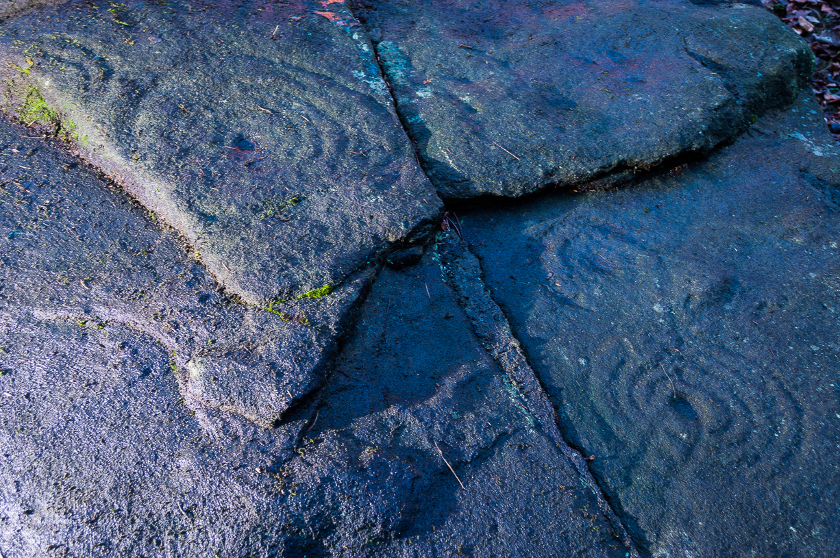
‘Stone D’ is just next to ‘stone C’, but with rather more ornate designs etched upon it. This is one of the more archetypal petroglyph designs that are found in the photo-guides and textbooks. Morris (1981) told that it consisted “of a cup-and-two-complete-rings and 2 cups-and-one-complete-ring up to 20cm in diameter, also a cup-and-one-complete-ring and 2 cups.” The photo here shows it pretty clearly.
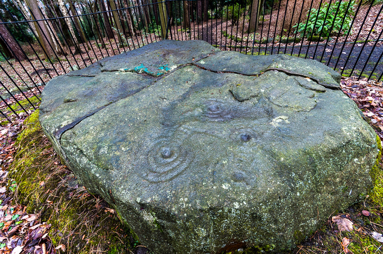
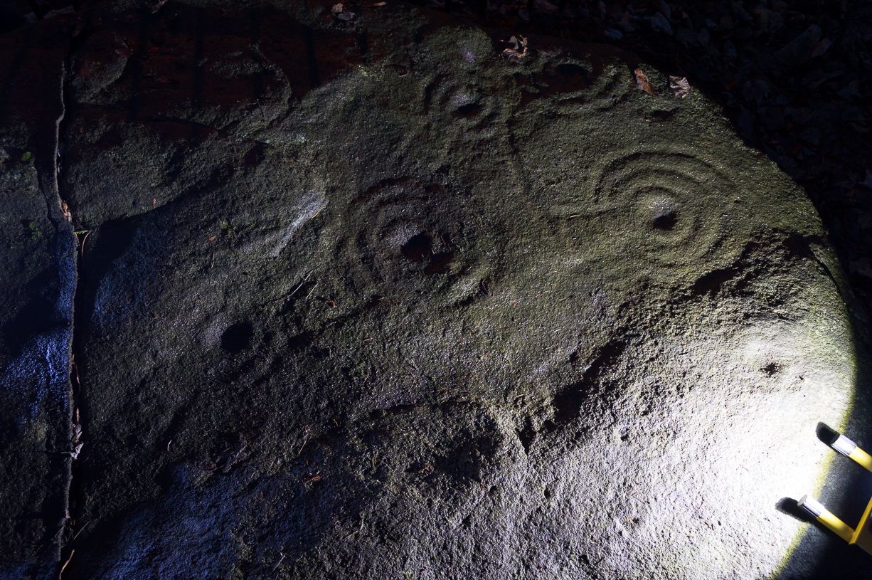
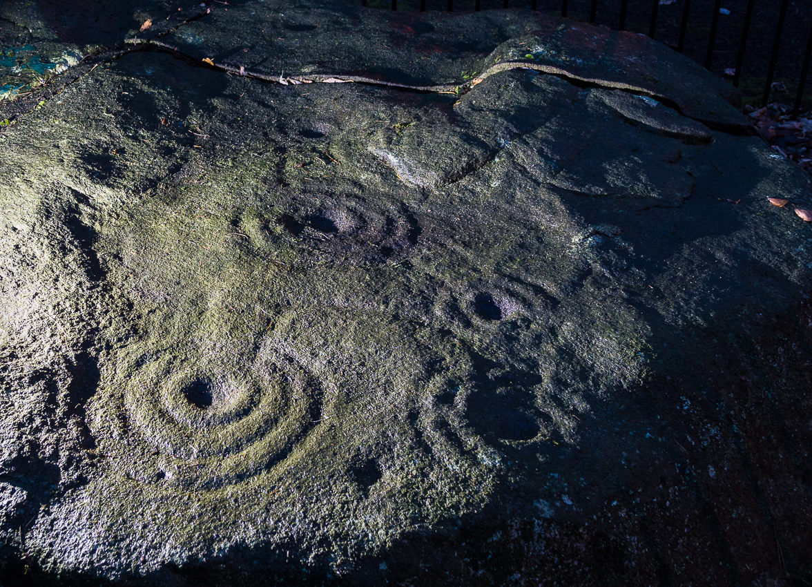
Carved Stone ECurious ‘bowl’, top-centre
‘Stone E’ is the next one along, just a foot or two away and Mr Morris (1981) told that the carving consists of “2 cups-and-one-ring up to 13cm in diameters, 1 complete, the others gapped, joined by groove to a cup, and at least 33 cups (C.G. Cash counted 42 in 1911).” Most of the carved elements on this rock are around the edges of the stone. A very large faded circular depression, man-made, is also visible on this section of the petroglyph (above left), suggestive of lunar symbolism.
Carved Stone F
‘Stone F’ is less than 10 yards further west and has the greatest number of cup-markings of the entire group here, as Morris described: “3 cups-and-one-complete-ring up to 9cm in diameter, and at least 80 cups, a few of which are widely scattered over a big area sloping steeply further south, beyond the attached diagram.” It’s perhaps the most notable of the carved rocks along the ridge here — not by virtue of its design, more its geological physique than anything else.
Carved stone G
‘Stone G’ is next along and has a curious look about it, suggestive of more modern times. At first sight it doesn’t seem to have quite the magnitude that Morris’ description affords it, but on closer inspection by rolling some of the covering turf back away from the rock, you can see what he meant. This stone has “10 cups-and-one-complete-ring, up to 10cm diameter…and also 15 cups.” One of the cup-and-rings on this section was found by Morris to have been “the smallest so far recorded by the author in Scotland.”
Then we reach ‘stone H’ at the eastern end of the carved ridge, consisting of simply 3 cup-markings. One of them has a faint arc pecked around it. Further along the rock, a complete cup-and-ring is visible close to the edge.
This entire line of petroglyphs is a fine place in a fine setting, perfect for meditative practices! Other carvings can be found close by: Duncroisk 3 is a coupla hundred yards east across the field just over the fence by the riverside; and Duncroisk 2 is on the other side of the fence down towards the River Lochay on the same side of the adjacent burn less than 100 yards away (though this is trickier to reach). Other prehistoric sites can be found not too far away…
Folklore
Local people tell of having seen curious lights flitting along the edges of the field, river Lochay and roadside close to the carved rocks hereby.


")
")
")


")
")
")
")
")

")
")