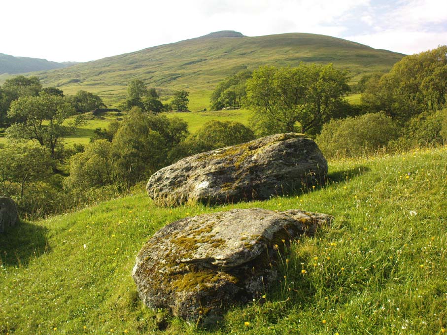
Takes a bitta finding this one – especially a this time of year when the bracken’s high – but it’s worth the walk. You’re probably best finding your way to the open-air carving on the slopes above Westcliff Farm, the Guisecliff Wood 626 carving (it’s pretty easy to find). From here, walk eastwards across the top of the two fields until you hit the old gate that take you back into the woods. Now it gets difficult! Walk less than 100 yards in the same direction, if you’re lucky, along the small footpath that runs pretty level through the trees, keeping your eyes peeled for a large sloping rock above you. I’d say that it’s probably best to start checking the relevant rocks (large ones) after 50 yards in the trees, just to be on the safe side. If you aint been here before it’s probably best to check it out at the end of Winter or during Spring time. Good luck!
Archaeology & History
As noted by several people in our visit here the other day, some aspects of this carving are similar in design to the Tree of Life Stone on the eastern edge of Askwith Moor, 10 miles south of here. But the features on this large carved rock have intriguing elements of their own here: not least of which is the large square ‘box’ into which a cluster of otherwise normal cup-and-rings are enclosed. It’s a unique feature in prehistoric carvings in this part of the world — although such ‘box’ motifs can be seen further north at Dod Law in Northumberland.
The fainter cup-and-ringsBoughey & Vickerman’s 2003 drawing
There are two distinct sections of carvings on the stone, both of which have a similar tree-motif patterns, but the boxed one grabs your attention more once you’ve sat with the stone for a while. The other small cluster of cups are a little more difficult to notice, but once you see them they almost grow into life! You can just make out the surrounding rings and lines around some of these fainter cups, which I tried to capture in the photos (but without much success).
Our visit here didn’t pass without some voicing the thought that ‘box’ section could have been added at a much later date — perhaps a Victorian addition? But we could be way off the mark with that one!
There’s every likelihood of other carvings being found in and above the woodlands here, though any further exploratory excursions here can wait till winter time, as the Nature’s summer growth here is considerable and covers most of the rocks in green. The carving was first described in Boughey & Vickerman’s (2003) text as a
“Very large rock with extensive flat surface on which there seems to be two separate designs. Seven cups are joined in a branch-like pattern, the whole within a square groove from which the ‘stem’ of the branch just protrudes; away from this is an approximately linear feature with three cups enclosed by linked rings at one end and then six more cups with a partial ring.”
If you’re a rock art enthusiast, or a real healthy heathen, this site is well worth checking out!
References:
Boughey, Keith & Vickerman, E.A., Prehistoric Rock Art of the West Riding, WYAS 2003.
Take the same directions as if you’re visiting the Eastwoods Cross base and cup-marked stone, but at Eastwoods Farm itself, walk downhill following the field-wall, past the large house, then through the first gate you come to. (it’s got a ‘private’ sign on it and has some handy bulls in the field – but ask at the house and the folks there are friendly) Following the footpath along the top of the field, cross the small stream, then head across the next field to the gap in the wall. You’re here!
Archaeology & History
Boughey & Vickerman’s sketch
One of a cluster of cup-and-ring stones around the Bryan’s Wood and Eastwoods area, this carving is well worth a visit, but can be covered in shit and muck as the bulls pass through the gap here on their daily amble. If the daylight isn’t good here, it can be difficult to see the carving – and when we visited the place the other day, the cloud was low and the heavens were ready to open, so our luck was out for a change! There are a number of cup-and-rings plus a double-ring, fading their ways around the more defined cup-markings. The stone appears to have been found in the 1990s, but records of it are scant. Boughey & Vickerman (2003) fail to tell the origin of the name, nor when or who rediscovered the site. Their description of the carving tells simply:
“Large flat smooth rock sloping slightly to E. Thirteen possible cups, one with partial double ring and four with partial single-rings; three ringed cups have grooves leading from them.”
Several other excellent cup-and-ring carvings can be found around here. The hugely impressive Morphing Stone and a prehistoric lightning-carving can be found three fields away to the south, past the trees on the other side of the stream.
Folklore
Close-up of the stone
The title of ‘fertility stone’ seems a modern one, although word has it that it relates to Beltane fertility rites. However, I can find no documentary information relating to this, and the people at Eastwoods Farm and adjacent house know nothing to account for it.
References:
Boughey, Keith & Vickerman, E.A., Prehistoric Rock Art of the West Riding, WYAS 2003.
From Pateley Bridge take the B6265 road towards Grassington, turning left just a coupla hundred yards over the river bridge, towards Bewerley. Go through the hamlet and take the second on the right, up the steep zigzagging lane. A half-mile up the hill, watch out for the track onto Westcliff Farm. Go along here and onto the footpath, then as you walk through the field, look uphill where the long wall runs into the trees, and you’ll see a rock in the walling near the top. That’s it!
Archaeology & History
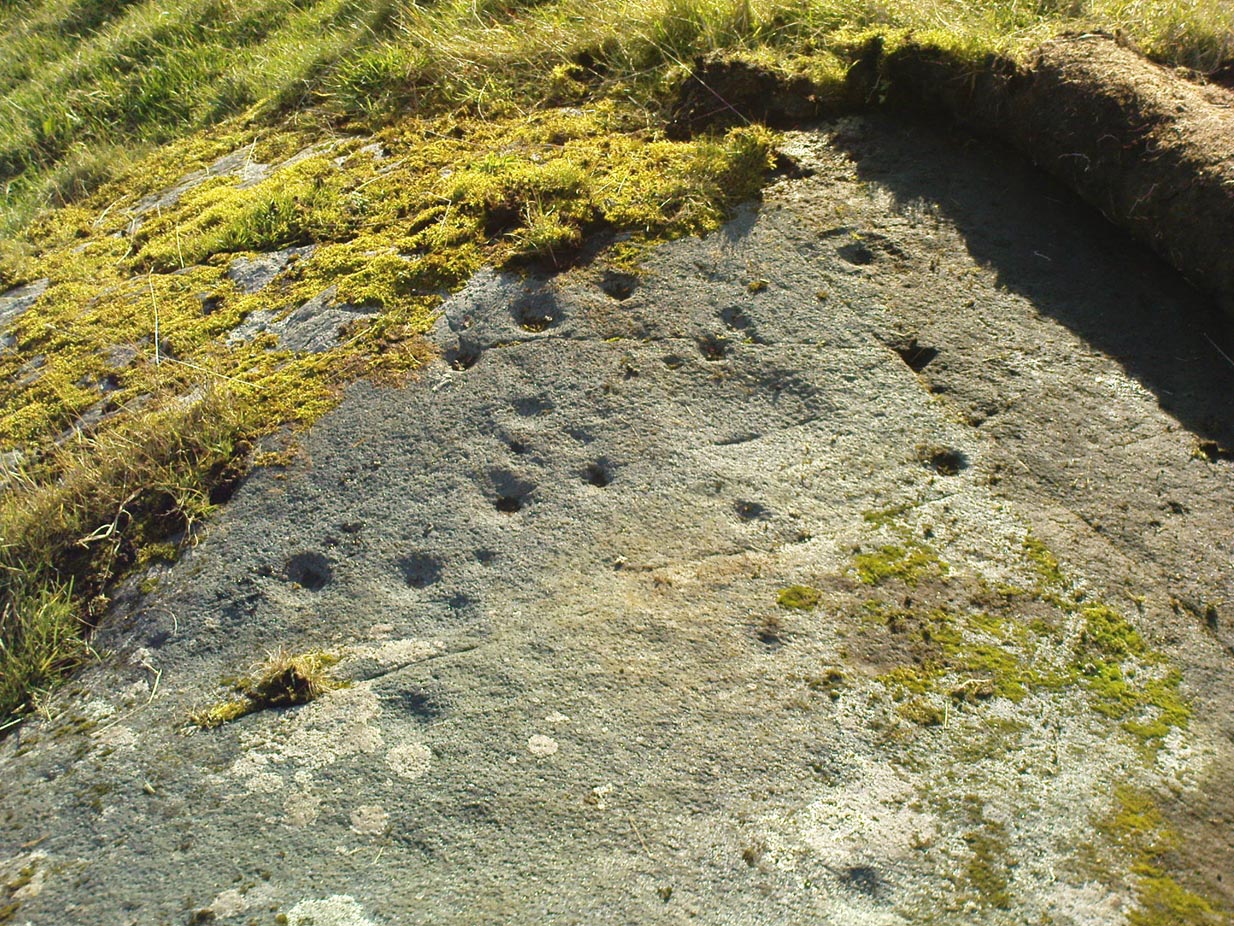
Just over the edge of the northern section of The Intakes at the western end of Guisecliff Wood, on a large rock in the walling near the very top of the field above Westcliff Farm, we find this little-known but very impressive cup-and-ring stone.
Close-up of some cupsBoughey & Vickerman’s sketch
Upon first sight the rock was aptly described by Danny Tierney as being like a Viking Hogback Stone with cup-markings along the sloping side of the long rock as it grew into the drystone walling. He had a point! It’s a curious carving (how many times do I say that!?), with the majority of the cup-marks and lines etched into the south-sloping face of the rock. Other cups found further down the stone stretch along the eastern side towards ground level; and we have a small line of cups etched onto the normal horizontal face halfway along the stone.
The carving was rediscovered by Stuart Feather in the ‘Sixties and was all-but-forgotten until Boughey & Vickerman (2003) rejuvenated it in their catalogue. They told it to be:
“Large rock of coarse grit lying with long uneven surface E to W, at ground level to S and E, but with high N and W faces. Up to eighty cups but some may be due to pebbles or other natural causes; one cup has two half-rings which, like some grooves visible, suggest a now incomplete design.”
The fascinating ‘boxed’ cup-and-ring stone of Guisecliff Woods 629 can be found less than 200 yards east of here, in the trees, and is certainly worth seeking out!
References:
Boughey, Keith & Vickerman, E.A., Prehistoric Rock Art of the West Riding, WYAS 2003.
Feather, Stuart & Hartley, C.E., “The Yorkshire Archaeological Register, 1964: Bewerley. W.R.”, in Yorkshire Archaeological Journal, volume 41, 1965.
Follow the same directions to reach the superb Badger Stone carving, and from here take the footpath that runs downhill. You’ll cross another footpath about 100 yards down the moor, but just keep walking down the path and you’ll notice the small copse of woods ahead of you. As the footpath begins to swerve roughly away, northeast, heading away from the said woodland, keep your eyes peeled on your left for a reasonably large but flattish rock close to the ground (in summer it’s surrounded by bracken) about 75 yards away. That’s your target!
Archaeology & History
Of the hundreds of cup-and-ring stones on Ilkley Moor and district, this is one of my personal favourites! I first visited the stone in 1977 as a young teenager and was mightily impressed by the unusual nature of the design here — and that impression still remains. Aswell as possessing the usual cups and rings, the Barmishaw Stone is one of just a few rocks also possessing a sort of ‘ladder’ design or linear pattern within the overall carving: an insignia echoed on the nearby Willie Hall Wood carving, the Piper Stone, and also on the Panorama Stones. As with the ‘ladders’ on the Panorama carving, those found here at Barmishaw are very eroded and are increasingly difficult to see during the daytime (the best time to notice them is usually around sunrise or sunset, and particularly when the rock itself is wet).
The carving has been described many times, albeit briefly, by a number of writers. In John Hedges (1986) fine survey he said the following:
“Medium sized flat-topped rock…fairly smooth grit, sloping slightly east to west, covered with carvings, some of which are very worn. Slanting sunshine needed to detect them. About twenty-four cups, at least nine with rings or incomplete rings, two with multiple grooves half round and continuing straight down, one of them incorporating ‘ladder.’ Five other ‘ladders’ – in a good light. Cups mostly deep and clear.” A few years later, Boughey & Vickerman (2003) echoed much of Mr Hedges description, though noted that of the 24 cups with their rings, one possessed a triple ring.
Alan Davies’ illustration
Like so many cup-and-ring stones, they have given rise to hosts of fascinating theories and ideas — one of which is based on mathematics and metrology. In the 1980s, Alan Davies (1983, 1988) surveyed the Barmishaw Stone — and other carvings on Ilkley Moor — to explore the possibility that the cups and rings were laid out according to a basic unit of measure, the Megalithic Inch (MI), as proposed by Alexander Thom some years earlier. Although Davies’ work showed that such a primary unit of measure wasn’t to be found universally, his research at the Barmishaw Stone indicated “significant evidence for quanta of…3 MI,” although this occurred “when the analysis is restricted to only ringed cups.” Despite this, Davies thought that the existence of the Megalithic Inch was evident in this and other carvings on the moors, stating that:
“The repeated emergence of the significance of ringed cups, and the fact that all putative quanta seem to bear a simple numeric relation to each other do not seem to be coincidental.”
Although it has to be said that the selectivity of data in Davies’ research is more indicative that the Megalithic Inches in the the carvings was due, neither to chance nor mathematics, but more that the implements used to carve the rocks and the size of the hands of the people doing the carvings was pretty uniform and so, as a result, would give an obvious window of numeric similarities that can easily be mistaken as a deliberate metrology. These simplistic factors need assessing. In modern trials that we’ve done carving cup-markings, we’ve found them to be of similar size to those carved in prehistoric times—as you’d expect.
Barmishaw Stone (after Hedges, 1986)Barmishaw stone (Cowling 1946)
The ladder motif central to this carving may have related to early religious and ritual events here. Across the world, indigenous cultures commonly relate the ‘ladder’ to be a symbol of ascension, both by shamans, mystics and during rites of passage. The symbol represents the journey of the soul to and from supernatural realms. To discount this possibility at the Barmishaw Stone would be shortsighted.
The carving was very probably painted when our neolithic ancestors gathered here, much as Australian aborigines still do to their carvings using lichens and other plant dyes, with the respective ladders and lines changing colour where movements between worlds or shifts of attendant spirit occurred. By virtue of the its very name, I consider this rock to have been considerably important; the “ghost” aspect to barmishaw being a typically misconstrued aspect of ‘spirit’.
Folklore
This excellent cup-and-ring marked stone probably derives its name from the old dialect words “barm i’ t’ shaw”, meaning “ghost in the wood” stone. Whatever guise the attendant spirit of this rock may have had has long since been forgotten; though spectral accounts from the beginning of the nineteenth century until modern times may give us clues. There have been several reports of green-coloured elemental creatures around the area between here and the White Wells sacred spring a short distance to the east. The most recent account, from 1987, took on the modern mythic form of a little green man from space, with attendant UFO to boot! The Barmishaw Hole nearby was a place where faerie-folk used to live. Excesses of geological faulting and water makes the magickal nature of this place particularly potent.
References:
Allen, J. Romilly, “The Prehistoric Rock Sculptures of Ilkley,” in Journal of the British Archaeological Association, volume 35, 1879.
Allen, J. Romilly, “Notice of Sculptured Rocks near Ilkley,” in Journal of the British Archaeological Association, volume 38, 1882.
Bennett, Paul, “Cup-and-Ring Art”, in Towards 2012, volume 4, pp.83-92, 1998.
Bennett, Paul, The Old Stones of Elmet, Capall Bann: Milverton 2001.
Boughey, Keith & Vickerman, E.A., Prehistoric Rock Art of the West Riding, WYAS: Wakefield 2003.
Cowling, E.T., ‘A Classification of West Yorkshire Cup and Ring Stones,’ in Yorkshire Archaeological Journal 1940.
Cowling, E.T., Rombald’s Way: A Prehistory of Mid-Wharfedale, William Walker: Otley 1946.
Davis, Alan, ‘The Metrology of Cup & Ring Carvings near Ilkley in Yorkshire,’ Science Journal 25, 1983.
Davies, Alan, ‘The Metrology of Cup and Ring Carvings,’ in Ruggles, C., Records in Stone, Cambridge University Press 1988.
Eliade, Mircea, Patterns in Comparative Religion, Sheed & Ward: London 1958.
Hedges, John (ed.), The Carved Rocks on Rombalds Moor, WYMCC: Wakefield 1986.
Wright, Joseph, The English Dialect Dictionary – volume 1, Henry Frowde: Oxford 1905.
Pretty easy to find this. Go up Glen Lochay for 3 miles or so, on the road past the brilliant Stag Cottage carvings for a couple of hundred yards where you’ll see an old run-down army-looking building and past that is a curious large wooden and wire construction. Go up the farm-track next to this, past Duncroisk Farm, taking the footpath through the gates that go up to the side and behind the farm. You’ll see a rounded grassy knoll ahead of you. Head straight for it!
Archaeology & Folklore
This carving would appear to have been described for the first time by Mr Cormack (1952) in his longer essay on the cross-marked stones nearby. He said briefly:
“On the top of a small rock-strewn knoll about 300 yards behind Duncroisk farmhouse is a recumbent boulder, at one corner of which is a group of five fairly deep cup-marks of 2- to 3-inch diameter.”
Little else has been said of the site and even Ron Morris (1981) only gave the carving a brief mention in his survey, saying in passing how “east of a prominent rocky knoll, on whose summit is a cup-marked boulder…”, as he journeyed further uphill to explore the fascinating Duncroisk 4 carving with its scant cup-marks, human figurine and other curious insignia. And although this carving is probably only worthwhile for the real fanatics amongst you, I like the place — sad fella that I am!
Cup-marked stone, looking southClose-up of cups
There are five very distinct cup-marks etched onto a small, almost triangular section of the rock, sat close to a couple of other larger stones on top of the grassy knoll overlooking the glen, not far from some iron age walling. The cups are etched onto the topmost (northern) section of the rock, which is defined by a natural crack running across the surface, almost splitting one part of the stone from the other. The five cups are in no discernible linear formation. A possible sixth cup-mark and extended line may have been started on the other side of the crack on the stone, but its execution was stopped for some reason. This is by no means certain though.
Of some note is the larger stone immediately adjacent on top of this knoll, which — as Paul Hornby pointed out — is encrusted full of small garnets all over its surface. This may or may not have some significance to the cup-marked stone here. According to Mr Hornby, the nearby cup-and-ring stone at Duncroisk Burn also has garnets in it.
Morris, Ronald W.B., The Prehistoric Rock Art of Southern Scotland, BAR 86: Oxford 1981.
Royal Commission on the Ancient & Historical Monuments of Scotland, Archaeological Sites and Monuments of Stirling District, Central Region, Society of Antiquaries of Scotland 1979.
Corrycharmaig 3 stone, with Meall Dhuin Croisg rising…
Go thru Killin and, just past the Bridge of Lochay hotel, take the tiny road on your left. Go down here for 3 miles till you pass the gorgeous Stag Cottage (with its superb cup-and-rings in the field across the road) for another 300 yards, until you see Duncroisk Farmhouse set back on your right. On the other side of the road, go thru the giant deer-gates (close ’em behind you) to the river-bridge and across it. Walk along the track till you reach the turning to Corrycharmaig House on the right (over the stream), but here, go up into the field thru the gate. Walk up the hill ahead of you with its trees on the left, walking up onto the grassy level, then up again to the rounded knoll another 100 yards up. You’re here!
Archaeology & History
This is the most visually impressive of the set of four cup-marked rocks along this ridge — although if you visit here when the light is poor, or the sky’s overcast, you’ll be lucky if you can actually see much of the material. For example, I counted 38 cups on this particular stone on a day when the sky was bright, but upon checking later, found that Mr Morris (1981) described there being, “40 widely scattered cups of which, however, 29 well-defined cups are in a compact group of which 6 are in line.” Whereas more recently the Canmore website told there to be,
Corrycharmaig-3 carvingClose-up of line of cups
“At least 48 cupmarks are visible on the most westerly exposure. The cupmarks range in size from 25mm in diameter and 5mm in depth to 100mm in diameter and 40mm in depth. A straight line of six cupmarks arranged close together is orientated running from NW to SE.”
This line of six cups is very distinct and stands out as the most notable aspect on this carving, probably because it gives a sense of ‘order’ or linearity, whereas the rest of the carving (as with oh so many of them, thankfully) possess that non-linear feature of scattered cups and lines, dissolving reason and ego, and eliciting the natural meditative state, if one so cares to allow. On our most recent visit here, our eyes and fingers traced what appeared to be the faint remains of a carved line running along the bottom edge of the row of cups and then bending around the bottom cup in the same line — a little bit like the carved lines which run around the edges of the row of cups on Ilkley Moor’s Idol Stone. You can just make this ‘line’ out in the photo, below.
Cup-mark and flintClusters of cups and faint line
On one visit to the site when we’d stayed with the late great Lindsay Campbell of Stag Cottage, other sections of this carving were visible that we’d previously missed, highlighting at least 45 cup-marks that we counted. Several of the cups had been exposed by animals (sheep or deer – we couldn’t tell) cutting into the soaking wet earth and in carefully checking a couple of cups whose edges were exposed, found a small worked flint within one of the cups! I looked at it, held it, puzzled over it, then laid it back where we’d found it. You can see it in the photo here, on the right.
This carving obviously grows on you with time. And like its carved companions of Corrycharmaig (1), (2) and (4) both left and right of here, the stone rests within a natural theatre of dreams, eliciting — if only in a slight way — the non-focal perspective necessary to receive the carvings as its executor knew…
Morris, Ronald W.B., The Prehistoric Rock Art of Southern Scotland, BAR 86: Oxford 1981.
Royal Commission on the Ancient & Historical Monuments of Scotland, Archaeological Sites and Monuments of Stirling District, Central Region, Society of Antiquaries of Scotland 1979.
Cup-and-Ring Stone: OS Grid Reference – NY 0708 2536
Getting Here
Photo & drawing of Dean’s cup-and-ring (after Beckensall 1992)
St Oswald’s church stands at the western edge of the village of Dean beside the road to Branthwaite. The village is located some 5 miles due south-west of Cockermouth and about 6 miles to the south-east of Workington.
Archaeology & History
In the nave of St Oswald’s church there is now housed a small sandstone boulder that has a well-defined central cup-mark around which are two large concentric rings, a third ring being left open – perhaps indicating a portal (gateway), and three other well defined cup-marks at the side of that, one of which has become almost adjoined to the other through erosion.
The boulder was ploughed up in a field at nearby Park Hill to the south-west of the village in 1918. It was then placed in the churchyard but, in recent times it was brought into the church for safety reasons.
References:
Beckensall, Stan, Cumbrian Prehistoric Rock Art, Abbey Press: Hexham 1992.
Beckensall, Stan, British Prehistoric Rock Art,Tempus: Stroud 1999.
Beckensall, Stan, Prehistoric Rock Art in Cumbria, Tempus: Stroud 2002.
Two real ways to get here. Either (i) follow the directions to get to the Stag Cottage carvings of Duncroisk 1, then walk down to the fence by the riverside and walk along to the left for a coupla hundred yards till you reach a second metal fence-post sticking out of a rock on the other side of the deer-fencing; or (ii) from the roadside burn a coupla hundred yards along the road before you reach Stag Cottage, follow it down to the riverside, then head along the footpath behind the fencing, parallel with the river’s edge. It aint far. Within 100 yards you’ll reach the stone with the metal pole sticking out of it and the carvings are on this!
Archaeology & History
Confusingly redesignated as Duncroisk 5 carving by the usually efficient Canmore people, we’re sticking with this stone’s original name given by Ronald Morris (1981) in his British Archaeological Report of this and nearby carvings — and a quite fascinating carving this is as well!
C.G. Cash’s drawingDuncroisk 3 stone
As with many cup-and-rings, erosion and lighting has a powerful effect on seeing the design correctly. On my visit here in recent months there were quite distinct additional elements in the carving which haven’t been noted by previous archaeologists. But in saying that, there were also some elements that were reported by the earliest antiquarians that proved difficult to see in the grey light of day when I was here. The earliest report of the carving by C.G. Cash (1912) told there to be five rings, whereas today only 3 or 4 are visible (though this will probably change when viewed in other lighting conditions).
When Mr Cash told of this stone in his essay on the antiquities of Killin it sounded as if it was lucky to have survived, as it had previously been dug out and left by the roadside, before then being reused by a local to fix a fence-post in! Mr Cash told us that the local,
“had used it as the foundation stone of the stretching post at the south end of the easternmost fence on the farm, and there I found it, near the brink of the river, buried in sand and turf. I cleared it and then in pouring rain crouched over it to make a hasty sketch. It bears eighteen cups, of which five are surrounded by rings. The largest cups are 2½ inches and the rings 6 inches in diameter.”
Ron Morris’ images
When I visited the place the weather was much the same as Mr Cash described: lovely teeming rain, typical of the mountains, with the surrounding trees breathing moisture onto the slopes as ever.
Years later when Ronald Morris (1981) came here he saw “4 cups-and-one-ring…probably complete rings, up to 12cm (5 in) in diameters and 10 cups up to 2cm deep.”
If you stand and face the stone, the cup-marking on its lower right side (see Morris’ old photo, above) has a pecked line running from it further to the right and down to the edge of the rock. You can clearly make it out on the top photo. This carved line also seemed to touch another carved line which can be seen running along the outer edge of the stone — although the poor light didn’t allow me to view this with absolute confidence. I’ll have another look at it again when I’m up in the area in May and hopefully confirm or deny it with greater confidence (and if anyone else gets here in the meantime, have a look and see what y’ think).
From Hebden Bridge, take the Heptonstall road and go past the legendary Slack Bottom (no lies!), until a few hundred yards further on at Slack Top, take the Widdop road on the right. Amble the long and winding road for a mile – mebbe a bit more – until the valley on your right runs out of trees! (on the OS-map this is called Hebden Dale, but it’s generally known as Hardcastle Crags [after the name of the rock outcrop halfway up]). Just about here there’s a track to your left, by the rather desolate bus-stop! If you hit the wibbly hair-pin bend by the Blake Dean scout-hut, you’ve gone too far. Walk along the track for a coupla hundred yards and take the first opportunity you have to cross the deep dike on your immediate left. Then just walk along the edge of the stream itself until you reach the large rocks another few hundred yards along.
Archaeology & History
As Richard Stroud’s photo above shows, this is a beautiful spot — when the weather is good anyway! Much of the landscape around you is scattered with occult history and folklore: boggarts, witches, corpse routes, spirit animals, old stone crosses, standing stones and more! A damn good day out can be had in this area by any enthusiastic antiquarian or enquiring heathen.
Cups and faint rings
The carving we have here is an almost typical cup-and-ring stone, but it’s pretty isolated with no other ringed companions anywhere on these hills. It was first described in David Shepherd’s (2003) survey of prehistoric remains of the region — although I was initially a little cautious about the veracity of David’s findings, as some cup-marked stones in his survey are probably natural and some “standing stones” he cites nearby are simply natural earthfast rocks. But this particular carving seems man-made with large faint rings encircling at least one of the cup-marks, as you can see in Richard Stroud’s photo here. In Mr Shepherd’s survey, he said of this site:
“A prominent double boulder. On the top surface are two eroded cup marks by the south edge and one by the north edge. Two eroded cup marks with rings are on the northwest segment.”
References:
Shepherd, David, “Prehistoric Activity in the Central South Pennines,” in Transactions of the Halifax Antiquarian Society, new series, volume 11, 2003.
Acknowledgements: With thanks to Richard Stroud for use of his photos in this site profile.
From the north side of Killin, take the minor road next to the Bridge of Lochay Hotel at Killin, past the hydroelectric station, through the wooded section until the fields open out again. The first gorgeous old house you come to is on the right-hand side of the road. Stop here! (I could really do with living here misself – tis a truly superb place!) You can ask the lady at the house where the carvings are and she’s very happy to point them out – they’re on the rocky crag near the bottom-end of the field on the other side of the road.
Archaeology & History
R.W.B. Morris sketch of the main carvings
What a brilliant setting and clump of carvings we have here! As you get to the rocky hillock in the field, you see that there are numerous rocks visible along the ridge, a number of which have carvings on them – some with just cups, but most possess a number of cup-and-rings. It’s an excellent spot! Depending on the time of year when you come here will determine whether or not you get a better look at the carvings or not. I’d recommended April and May as the best time, as the vegetation is at its lowest then. Visiting the site near the end of summer doesn’t give you as good a view — but even then, if you like your rock art, you’ll still love it! The rocks here are mainly quartzite schist, with a number of the surfaces being almost pure quartz. Intriguingly, none of the pure quartz sections appear to have been carved on.
The carvings here were first mentioned in an article by D. Haggart (1895), who described them as “a very remarkable set of incised rock sculptures…discovered lately in this neighbourhood by Mr John McNaughton.” And remarkable they are indeed! In Ronald Morris’ (1981) survey of this site — which he labelled Duncroisk 1 — he counted eight separate rock surfaces that had been carved, marking them as carvings a-h, but there are at least eleven of them here; and in all honesty, if we could strip the surface of the hill of its vegetation, we’d probably find a few more hidden away!
Cup-marked stone
As you’ve walked across the field from the road, past the first unrecorded cup-marked stone near the start of the rocky rise, we reach Mr Morris’s ‘stone A’ near the easternmost end of the ridge, which is just a small slab of stone with “at least 6 cup-marks” on its surface. It’s easily missed in poor light, so watch out. However, if you reach ‘stone b’ (described below), just walk back ten steps and you’ll see it.
Carved Stone B
Ten yards west is ‘Stone B’, seemingly split into two sections, whereupon we find “a cup-and-two-rings and at least 12 cups-and-one-ring, up to 19cm in diameter – some rings gapped, others not, some with and some without a radial groove from the cup, and some with a “runner” or cup in a ring. There are also at least 58 cups” on this section of rock. ‘Stone C’ can also be missed, this time due to its size and the fact that the larger cup-marked surfaces are ahead of you. But assuming you don’t miss it, this carving consists of “a well-preserved cup-and-two-complete-rings 25cm in diameter, and a cup.”
Carved Stone D
‘Stone D’ is just next to ‘stone C’, but with rather more ornate designs etched upon it. This is one of the more archetypal petroglyph designs that are found in the photo-guides and textbooks. Morris (1981) told that it consisted “of a cup-and-two-complete-rings and 2 cups-and-one-complete-ring up to 20cm in diameter, also a cup-and-one-complete-ring and 2 cups.” The photo here shows it pretty clearly.
Carved Stone ECurious ‘bowl’, top-centre
‘Stone E’ is the next one along, just a foot or two away and Mr Morris (1981) told that the carving consists of “2 cups-and-one-ring up to 13cm in diameters, 1 complete, the others gapped, joined by groove to a cup, and at least 33 cups (C.G. Cash counted 42 in 1911).” Most of the carved elements on this rock are around the edges of the stone. A very large faded circular depression, man-made, is also visible on this section of the petroglyph (above left), suggestive of lunar symbolism.
Carved Stone F
‘Stone F’ is less than 10 yards further west and has the greatest number of cup-markings of the entire group here, as Morris described: “3 cups-and-one-complete-ring up to 9cm in diameter, and at least 80 cups, a few of which are widely scattered over a big area sloping steeply further south, beyond the attached diagram.” It’s perhaps the most notable of the carved rocks along the ridge here — not by virtue of its design, more its geological physique than anything else.
Carved stone G
‘Stone G’ is next along and has a curious look about it, suggestive of more modern times. At first sight it doesn’t seem to have quite the magnitude that Morris’ description affords it, but on closer inspection by rolling some of the covering turf back away from the rock, you can see what he meant. This stone has “10 cups-and-one-complete-ring, up to 10cm diameter…and also 15 cups.” One of the cup-and-rings on this section was found by Morris to have been “the smallest so far recorded by the author in Scotland.”
Then we reach ‘stone H’ at the eastern end of the carved ridge, consisting of simply 3 cup-markings. One of them has a faint arc pecked around it. Further along the rock, a complete cup-and-ring is visible close to the edge.
This entire line of petroglyphs is a fine place in a fine setting, perfect for meditative practices! Other carvings can be found close by: Duncroisk 3 is a coupla hundred yards east across the field just over the fence by the riverside; and Duncroisk 2 is on the other side of the fence down towards the River Lochay on the same side of the adjacent burn less than 100 yards away (though this is trickier to reach). Other prehistoric sites can be found not too far away…
Folklore
Local people tell of having seen curious lights flitting along the edges of the field, river Lochay and roadside close to the carved rocks hereby.


")
")
")