Pretty simple this one. From Chipping Norton, head west on the A44 for a coupla miles till you hit the lovely Salford village. The church stands out, so head for it and, as you walk towards the building, watch for the small stone cross in front of you.
Archaeology & History
Salford Cross cup-markings
This is curious. Very curious! We might expect to find cup-markings occasionally on some of the cross-bases or other early christian monuments in northern England and Scotland, but to find them in the heart of a small Oxfordshire village where the tradition of cup-marked stones is unknown, was something of a surprise when Tom Wilson and I (1999) found it, to say the least! But this is what we’re looking at here.
Salford Cross remains
On the remains of an old medieval cross, whose broken shaft has seen better days, as the photo shows — and as a personal viewing shows even clearer — there are 3 simple cup-markings etched on one side of the cross-base in Salford churchyard. The cups certainly aint natural, but then also they don’t have the archaic looks of the prehistoric carvings from Yorkshire to Scotland. It would be good if we had a more extensive history of the cross monument itself, perhaps saying precisely where the stones which make it up came from, but local records tell us nothing it seems. If we could ascertain that parts of it were made up of some remains taken from some local prehistoric ‘pagan’ tomb (and a number of tombs have been found in and around this area), then some sense could be thrown upon its position here. But until we can ascertain more about the history of the cross, the three clear cup-markings on the cross-base remain somewhat of a mystery.
Folklore
Lovers of ley lore will be intrigued to find this carved cross-base is on a very accurate ley linking the King Stone, Rollright stone circle, Little Rollright church (where a standing stone can be found in the walling just before it), the Salford Cross and the site of another cross on the hill outside the village.
References:
Bennett, Paul & Wilson, Tom, The Old Stones of Rollright and District, Cockley: London 1999.
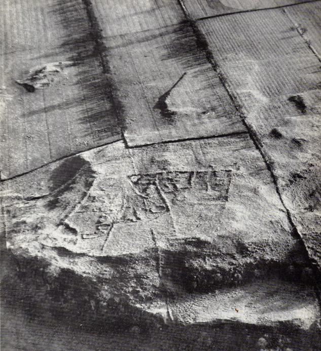
Aerial view of settlement, 1967 (courtesy, Antiquity journal)
Some of the extensive remains of an Iron Age settlement on the northeastern edges of Barrasford Common, on the edge of Toddle Crags a couple of miles north of Chollerton, are thankfully still visible, despite the increased quarrying operations taking their toll on other (now lost) prehistoric sites between the little villages of Gunnerton and Great Swinbourne. The remains of earthworks and walling are clearly visible at ground level, despite being overgrown.
The archaeologist J.K. St. Joseph (1970) described them in a short piece in Antiquity journal more than 40 years ago, saying:
“The site as first described by the reverend G. Rome Hall (1876) in the course of a survey of settlements around Birtley and Barrasford, made a century ago. It is the easternmost of three settlements that he noted on the crags east of Gunnerton, and his sketch-plan shows rather irregular enclosures within which appear a dozen hut-circles, between 27ft and 15ft…in diameter according to his account. The western of the three settlements was subsequently excavated by Rome Hall about 1880, and re-examined in 1941 by Mr A.H.A. Hogg (1942), who was able…to show that the period of occupation fell within the Roman Age. Mr Hogg refers to the earthworks illustrated (above) as ‘a very large settlement, much robbed.’
“…The site consists of a roughly square enclosure, 300ft across, or a little more, defined by a low bank… The SW and SE sides are straight: on the other two sides the boundary mark conforms to the cont0urs of the ground. The enclosure is subdivided, and evident traces of hut circles and of more rectangular-shaped buildings are still to be seen. Some of the small compounds may be pens for stock, and the general impression conveyed by the earthworks is of a settlement that has developed over a period of time, additions and rebuildings being involved. It is thus a notable example of the rectangular settlements of the Roman Iron Age, which occur widely in south Northumberland, as Mr G. Jobey has demonstrated. The earthworks compare well in point of weathering, at least in an aerial view, with the best preserved of the Iron Age settlements on the moors in the north of the county.”
The writer notes how the this settlement had evidence of continued human use all the way from the Iron Age to perhaps as late as the 18th century! This isn’t too unusual. The best example I’ve yet to come across is the little-known settlement complex in the far north, on the small plateau known as Baile Mhargaite near Bettyhill, Sutherland, where a living community began in the neolithic period and only came to an end with the Highland Clearances two hudnred years ago!
References:
Hall, George Rome, “Ancient British Remains near Birtley and Barrasford, North Tyne,” in Archaeologia Aeliana, Volume 7, 1876.
Hogg, A.H.A., “The Native Settlement at Gunnar Peak,” in Archaeologia Aeolina, Volume 20, 1942.
From Laneshaw Bridge, near Colne, take the long country road that goes up above Wycoller to Stanbury and Haworth over the Yorkshire-Lancashire border. A couple of miles uphill, there’s a parking spot with views across the moors. Stop here. Cross the road and walk up for about 100 yards, going thru the rickety gate on the left, and up the field (past the small disused quarry) until you see the large rock looming ahead of you, perched on its own. That’s it!
Archaeology & History
Herders Cross stone
This is a really curious spot to me. A large singular boulder sat on the edge of an uninhabited moorland with no real history of heathenism, nor religious practices; yet someone at sometime in the not-too-distant past saw something here that made them cut a large square hollow into the top of this stone, in which they stuck an old cross. We came across this site a few weeks ago quite by accident, but realised that the deep hollow in the rock was an old cross base; so when I got home I checked Taylor’s (1906) magnum opus, expecting to find some info therein. But even Taylor seemed to know nothing of this place.
A week or two later, Paul Hornby pointed me in the direction of an unpublished essay by a local chap called Clifford Byrne (1974) who’d studied some of the early christian remains in the region and who wrote the following of what he named “Herders Cross”:
“This cross, or more properly its socket, is probably one of the least known in the area. It was shown to the writer by Mr Stanley Cookson of Trawden, who discovered the socket in passing, so to speak. On the road to Haworth from Laneshawbridge, opposite the site of Foster’s Leap rocks, on the east side of the road, is a really huge boulder on the moor top. In the south side is the cross socket, whilst on the north side of the rock can be made out a right-angled mark which implies that either the socket was being placed on that side in the first instance, or that two sockets were once envisaged…
“Old maps show the rock in situ with a “shaft” protruding from the top. Some yards west a shallow pony track bypasses the site, whilst some four or five hundred yards east a very well worn and ancient road, long unused, passes in the direction of Emmot Holy Well. The cross may thus have been a Wayside Cross showing the way to this Holy spring which is remembered as being propitious in the cure of rheumatism.”
Cross-base socket
This may be so; but I suspect earlier, heathen remains upon the moors here to explain the curious position of both this and another cross-base some 400 yards away. Some dubious cup-marks can be seen by the side of the stone hollow; and other dubious ones have been found on the moors above here. There is folklore of a lost stone circle on the hills above here, and a scattering of little-known faerie lore, indicating hidden sites and lost myths. These ingredients are more likely the reasons that Herders Cross was erected here, overlooking the countryside south and west, with the holy hill of Pendle rising in the centre of the distant landscape…
References:
Byrne, Clifford, A Survey of the Wayside Crosses in North East Lancashire, unpublished 1974.
Taylor, Henry, The Ancient Crosses and Holy Wells of Lancashire, Sherratt & Hughes: Manchester 1906.
Go over Ilkley Bridge and take your first left, on & over the roundabout, then follow the road as it bends uphill. Keep going until you reach the fields and moors either side of you, up Hardings Lane, stopping at the bend in the land where it meets a couple of dirt-tracks. Go up the track onto the moor and follow this right into the moorland (avoiding the path to your right after a few hundred yards) where it follows the edge of the walling again. After a few hundred yards there’s a gate on your right. Go thru this and, after 40-50 yards, walk up into the heather. You’re damn close!
Carving no.484
Archaeology & History
This is another cup-marked stone that’ll only be of interest to the petroglyphic purists amongst you, as it’s another one of those incredibly interesting single cup-marked rocks — this time with an additional single line running from it! WOWWWW….! The photo here just about does it justice, as in some light conditions you wouldn’t even notice it. There’s also the possibility that this ‘carving’ was actually Nature’s handiwork.
It was first described by our old mate Stuart Feather in 1965, and was then included in Boughey & Vickerman’s (2003) survey as stone 484, describing it as, “medium-sized, approximately square rock of fairly smooth grit. One cup with groove leading from it.”
References:
Boughey, Keith & Vickerman, E.A., Prehistoric Rock Art of the West Riding, WYAS: Wakefield 2003.
Feather, Stuart, “Mid-Wharfedale Cup-and-Ring Markings: Nos. 36, 37 and 38, Middleton Moor, Ilkley,” in Cartwright Hall Archaeology Group Bulletin, volume 10, 1965.
ACKNOWLEDGEMENTS: to Richard Stroud for use of his photo
To be found a couple of hundred yards west of Askwith Moor Road, head towards the bottom of the row of grouse-butts, following the fence that runs into the moorland across from the dusty car-park.
Archaeology & History
Single cup-marked stone
This single cup-marked stone — list as carved stone no.529 in Boughey & Vickerman’s (2003) survey — was reported when some English Heritage doods came here and found this small upright stone (probably part of a larger prehistoric monument, e.g., walling or cairn) and gave the cup-marking their “all clear” stamp and thought it authentic. But if memory serves me right (which it doesn’t always do these days!), I’m pretty sure Graeme Chappell came across this possible carving in the early 1990s during one of our many forays over these moors. It’s a cute little thing — though only for the purists amongst you perhaps — but, of course, needs to be seen in the context of its proximity to the many other prehistoric monuments across this moorland plain.
References:
Boughey, Keith & Vickerman, E.A., Prehistoric Rock Art of the West Riding, WYAS: Wakefield 2003.
Go through the village of Stanbury, past the last of the two reservoirs until you’re on the western edge of Ponden. Stop and look up the slopes to your south. This spot was recently found and photographed by Richard Stroud: a curious-looking mound with all the hallmarks of being a forgotten tumulus. We’ve gotta check it out properly though!
Folklore
Although not in the archaeological records (not too unusual in Yorkshire it seems), the site does have some literary references and some all-too-common folklore motifs. Perusing my library for info about another nearby site (the Cuckoo Stones), I found the following said of this place in a rare book by James Whalley called The Wild Moor (1869, pp.103):
“It appears that some hills, as well as dales…have silvery names. There is a hill which is on the right hand on the way from Ponden House to Crow Hill Moor, which is distinguished by the beautiful designation of ‘Silver Hill.’ The hill is surrounded by a wall (I suppose to guard the treasure) and its surface is adorned with trees. Grey-headed men living on the borders of Crow Hill and Lancashire Moors affirm that during the Scotch rebellion here was deposited a large chest of silver, which was hid in the hill. It would appear as if the chest of silver is still there!”
This tradition was echoed a decade later by J. Horsfall Turner, and then again by Halliwell Sutcliffe in 1899, who reckoned the “vast treasure was said to have been buried during the ’45 rebellion,” adding how “the fields which climb this hill were well tilled aforetime through being constantly turned over in search of the treasure” – but nowt was ever found.
An additional bit of folklore tells of two spirits nearby: one of a man; another of a fiery barrel — either a remnant of earlier solar folk traditions hereby, or perhaps just an earthlight. One of these (the fiery barrel) rolled down the hill nearby; whereby the ghost of the man walked by the hillock along the track from Ponden House a little further east.
References:
Horsfall-Turner, J., Haworth Past and Present, J.S. Jowett: Brighouse 1879.
Sutcliffe, Halliwell, By Moor and Fell in West Yorkshire, T. Fisher Unwin: London 1899.
Stuck in the middle of the moor, at the bottom (southern) side of the Lippersley Ridge promontory. Head towards it from the Askwith Moor Road, along the track past Sourby Farm and onto the end. Then walk along the easy footpath which that takes you below the southern side of the ridge and, about 100 yards before getting to the end of the rise, look around in the heather. You’ll find it.
Archaeology & History
Graeme Chappell’s early photo of the carving
Graeme Chappell rediscovered this seemingly isolated cup-marked stone during one of our many exploratory ambles upon these moors in the early 1990s. The carving is a pretty simple one, consisting of between 10 and 12 cupmarks on the upper surface of a reasonably large elongated stone. No discernible rings or other lines seem to be visible. There are no other cup-and-ring stones close by; but two small prehistoric cairns can be found along the same sloping ridge east and west of here when the heather is low, and the larger Lippersley Pike Cairn stands out on the western end of the ridge 450 yards away. A more detailed exploration of this part of the moor may bring other previously unknown findings to light.
References:
Boughey, Keith & Vickerman, E.A., Prehistoric Rock Art of the West Riding, WYAS: Wakefield 2003.
In the superb work of the legendary J.R. Mortimer (1905) he tells what was found when him and his team excavated this “remarkable barrow,” as he called it. Although Mortimer’s contemporary researcher, Canon Greenwell (1877), also looked at the site, the “mound was covered with a clump of old fir trees” which prevented further examination at the time. Mortimer and his team seemed to have worked here when the trees had been felled and following “a three-week free use of the pick and shovel during July and August, 1878,” they opened up this prehistoric mound to see what lay within.
Their discoveries here were intriguing: for this wasn’t merely a burial site in its early phase but, moreso, a house of the dead no less, where the people whose bodies, or those who cremated ashes were deposited herein, lived in their spirit-life. It was an abode for the spirits of the dead. Mortimer’s lengthy notes tell the story:
“At the time of opening, it measured 4½ feet from base to summit, and the natural surface of the ground beneath it stood fully 1 foot higher than the present surface of the land for some distance round its margin. It was formed entirely of chalk rubble and soil, mainly obtained from an encircling trench, which on the northwest side was very deep and wide.
“We turned over the whole of this mound except its outskirts. Near the northwest margin there was an excavation (D on the plan) extending 8 to 10 inches below the base of the mound, and measuring 8½ feet by 6½ feet, the floor of which was covered with a film of dark matter, in which were small bits of burnt wood. No relic, nor the slightest trace of an interment was observed. A little west of the centre (at B) there was s still larger excavation, 18 inches deep. It contained rough chalk, but no traces of an interment. East of this was a third excavation (E), oval in form and 3 feet deep. Like the previous one it was filled with chalk and contained no relic or trace of a skeleton. The digging of these had preceded the erection of the mound, as there were no indications of it having been cut through. These excavations were doubtless graves, the bodies having entirely decayed.
“This was not, however, the case with the secondary and comparatively recent interments of six adult skeletons, found at the south-east side of the mound, 1 foot to 2 feet below its base. Though unaccompanied by any relic, the very narrow form of the graves and the extended and slightly flexed position of the interments alone showed them to be Anglo-Saxons.
“Below these secondary graves was an older and far more interesting excavation. Its form and position is shown on the plan at A. At first it was thought to be a huge grave, but as the work proceeded appearances indicating it to have served some other purpose were visible. Its filling-in was peculiar. It consisted of broken chalk, surface soil, and burnt wood, presenting altogether a very unusual arrangement. Along its centre for a distance of about 15 feet were six carbonized uprights of wood, 6 to 9 inches in diameter, at about equal distances and in a row. Wood ashes were also found on the sides and bottom, and scattered in the material filling the excavation.
“Also along the centre many of the large flat pieces of chalk stood on their edges, and at various depths were portions of animal and probably human bone, burnt as well as unburnt, and many fragments of a reddish urn. It was observed that the east end of this excavation became narrower and shallower. It now seemed evident that it was a habitation. Its form, as shown on the (above) plan, was oblong, with a ground floor 25 feet by 4½ feet; and its greatest depth was 6 feet. To its east end was a passage 11 feet long, gradually sloping to the surface.
“”On the south side, commencing at the inner end of the passage and extending inwards for about 12 feet, was a ledge or rock-seat, about 13 inches above the opposite side of the floor, as shown by the dotted lines in the plan and section. The whole width of the floor at the south-west end, for a distance of about 6 feet, was 10 to 12 inches above the centre and lowest part of the floor. The roof of the cave had most probably been formed of horizontal timber, supported by strong uprights of the same material, and then covered with a mound of earth and stones. The roof eventually gave way and the superincumbent earth and stones slid into the dwelling, several of the large flat stones…remaining on their edges.
“The abundance of wood ashes affords unquestionable evidence of the dwelling having been burnt. The preservation of the remains of the six uprights was due entirely to their having been completely charred. The fragments of red pottery are quite plain and belong to three or more vessels, which were probably used for domestic purposes.
“The roof of the cave must have fallen in long previous to the Anglo-Saxon interments, as where the skeletons were found, partly over the cave and partly upon the undisturbed rock, not the slightest distortion was visible, which would have been the case had not the filled-in portion under the bodies become firm. Near the south-side of the dwelling, at about the base of the mound, were several broken human bones and pieces of a dark-coloured urn. Probably these belonged to a disturbed Anglo-Saxon burial.
“We also found in the mound, between the graves E, B, D, a considerable quantity of detached animal and human bones; the latter indicated three or more individuals; a few of the bones showed traces of fire. There were also several small pieces of a dark plain urn.”
Mr Mortimer then commented on the unusual ‘habitation’ section within the mound, not thinking that the dead themselves “lived” here! But we can forgive him this small detail as his work in general was superb. The site was of course a decent East Yorkshire chambered tomb, wherein the dead were laid and, if entrance was ever possible by our tribal ancestors when it was erected, would have paid homage the ancestral figures buried here. Traditional death ceremonies were pretty inevitable I’d say.
References:
Mortimer, J.R., Forty Years Researches in British and Saxon Burial Mounds of East Yorkshire, Brown & Sons: Hull 1905.
Follow the same directions to get to the Dumpit Hill A stone circle; but instead when you get to the point where you need to walk off-track and into the heather to get to the circle, keep walking up the dirt-track for about another 200 yards, watching diligently thereby for a reasonable sized, fallen, “standing-stone”-like character just yards into the heather on your right (on your left, there’s a U-shaped dip where the wall is). This is the northern edge of the walled enclosure. From this fallen ‘standing stone’ follow the overgrown walling along carefully into the heather along and down the slight slope. You’re now either on the very edge, or perhaps going into the middle of the enclosure. Look around!
Archaeology & History
East section of walling
There’s no previous written history of this site, discovered for the first time last week on our sojourn to the Dumpit Hill stone circles, by Michala Potts. She didn’t seem too excited by it at the time, but an amble back to what she’d found got me going! (easily done) With the help of the heather being burned away, open and exposed was a distinct line of prehistoric walling — perhaps Bronze Age, perhaps later. It’s hard to tell.
Structurally similar to the enclosure walling at Horse Close and Rough Haw, either side of Skipton, a few miles to the south, here we have about 100 yards of walling seeming to enclose the eastern side of the small hilltop, but running into the heather on its southern edge and the moorland track on its northern side, where it disappears again, leaving no trace of what one would assume would be a consistent western section.
From the grid reference for the site, the line of walling runs northwards for about 20 yards before taking a very slight shift in direction for another 20 yards. Here the walling goes to the left (west) for another 20 yards, before edging slightly northwest and back into the heather. A section of the walling is visible at each end, though we lose any accurate trace of it after a short distance in the long heather. However, at the northwestern point in the enclosure walling, a very distinct long stone about 4 feet high leans at an angle in the ling. It seems apparent that this stone at one point in the not-too-distant past stood upright, making it the tallest stone here.
Northern section of wallingFallen monolith?
What may be other features can be seen inside this enclosure section: a possible hut circle and other portions of walling were noted. However, we didn’t spend much time exploring the site in detail, so there is a high probability of other prehistoric remains in and around this enclosure awaiting discovery. The site’s proximity to the stone circles of Dumpit Hill A and Dumpit Hill B should be noted; along with what the North Yorkshire’s Historic Environment Officer, Robert White, said were “three, possibly four small circular enclosures (about 9m in diameter)” a short distance away. A further survey of the site is necessary to enable us a better picture of what we’re looking at here.
Cup-and-Ring Stone: OS Grid Reference – NM 027 487
Also Known as:
Kettle Stone
Ringing Stone
Singing Stone
Archaeology & History
This is a fascinating large coastal boulder with around 53 cup-markings on it — but whether these are all man-made is a matter of debate. Some of them may be natural. However some of the cups have lines and faint rings around them, showing that at least they’re man-made; and also in one of the large cups are placed small pebbles, similar in form to the well-known Butter Rolls, or bullaun stone at Feaghna, Ireland.
Folklore
This large boulder (suggested to have been dragged and dropped here from the Isle of Rhum in an earlier Ice Age) is known in the modern tongue as the ‘Ringing Stone’ because, allegedly, if you knock the surface hard with another stone it supposedly chimes with a metallic noise. As one of the links below shows, however, it doesn’t necessarily do the trick! Local folklore tells that if the stone is ever destroyed, or falls off its present platform of smaller stones, Tiree itself will sink beneath the waves. Other lore tells that this great rock is hollow; and another that it contains a great treasure. According to Otta Swire (1964),
“Some believe this to be a treasure of gold, others claim it to be the resting place of the Feinn who there await the call to rescue Scotland.”
References:
Royal Commission on the Ancient & Historical Monuments of Scotland, Argyll – volume 3: Mull, Tiree, Coll and Northern Argyll, HMSO: Edinburgh 1980.
Swire, Otta F., Inner Hebrides and their Legends, Collins: London 1964.


")


