Students of anthropology, comparative religion, folklore, etc, have long known that some mountains, rock outcrops, rivers and other features on the Earth have been imbued with particular sanctity – i.e., are sacred. Some are deemed as the abodes of spirits (good & bad), gods and other transpersonal qualities. Most mountaineers and travellers talk of similar living qualities in Nature’s various forms. So it is that we also find sites across Britain with great myths attached to them. Examples that immediately spring to mind are Pendle Hill (Lancs), Schiehallion (Perthshire), Beinn na Cailleach (Perthshire), Simon’s Seat (N.Yorks), and many others that we see on modern OS-maps dedicated to such mythic characters as the Devil, Robin Hood, fairies, Thor, Grim and other deities. Although such sites are not generally thought of as being important in the lives of our ancestors, such places were imbued with similar animistic qualities as found at standing stones, megalithic rings and other human creations; but we can be damn sure that the spirit-qualities (genius loci) of Nature’s creations had much greater power than anything created by humans!
This stone has very similar qualities to the one found upon Mullach-geal, ⅔ of a mile to the west, as a place where ritual magick was performed. And, just like the Mullach-geal stone, we only have an approximate position of its whereabouts: “behind the village”, as Mr Sands (1878) said. The same words were used by other St Kildan writers when it came to describing the whereabouts of Tobar Childe, so we must assume it to be reasonably close to the old well.
Folklore
Mr Sands seems to be the first person to write about it, telling us,
“At the back of the village is a stone, which does not differ in external appearance from the numerous stones scattered around, but which was supposed to possess magical properties. It is called Clach an Eolas, or Stone of Knowledge. If any one stood on it on the first day of the quarter, he became endowed with the second sight — could “look into the seeds of Time,” and foretell all that was to happen during the rest of the quarter. Such an institution must have been of great value in Hirta, where news are so scanty. To test its powers I stood on it on the first day of Spring (old style) in the present year, but must acknowledge that I saw nothing, except two or three women laden with peats, who were smiling at my credulity.”
Charles MacLean (1977) mentioned the stone a hundred years later, but seems to have just copied this earlier description. Does anyone up there know its whereabouts?
References:
MacLean, Charles, Island on the Edge of the World, Canongate: Edinburgh 1977.
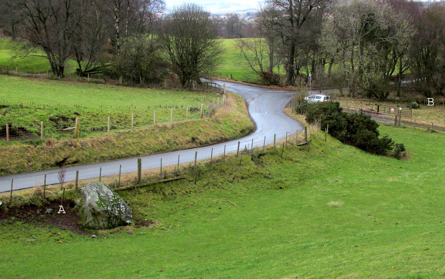
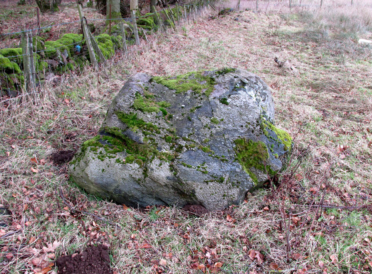
Travelling north from Perth on the A94, take the right turning for Murrayshall just before entering Scone, then take the first right and continue up to the road junction, and park up at the trackway opposite. You’ll see the big stone in the field to the right, up against the road embankment; and the small stone is in the paddock to the left of the trackway at the edge of the trees.
Archaeology & History
Two large glacial erratics which have acquired mythic status and picked up a Christian triumphalist message on the way.
Folklore
In Lawrence Melville’s (1939) excellent local history work, he thankfully put to pen an all-but-forgotten tale of oral tradition:
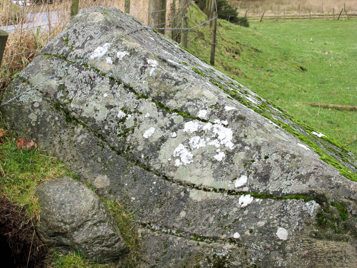
“Where the road from the Muir of Durdie leaves Kilspindie parish, a grass grown road leads north to Boglebee….. A few yards from the highway lie two large stones, said to have been flung from the Giant’s Hill in Collace parish – the flat topped eminence lying due north from the stones, about two or three miles away, better known as “Macbeth’s Hill”, or “Dunsinane Hill”.
The ‘string’ marks of legendThe smaller stone with its ‘string’ marks
“When the church dedicated to St John in Perth was being built and its tower began to appear, a witch living in Collace was enraged to see this proof of the approach of Christianity and determined to destroy it. She had a son, a giant (after whom the hill receives one of its names), whom she sent to the top of the hill, giving him two huge stones with which to destroy the rising church.
“By her incantations she had supernatural power and knew that when Christianity came her power would be destroyed. She gave him her mutch from her head to be used as sling and in it the giant put the two huge stones. Whirling it around his head, he aimed them in a line with the tower, but, just as he let them fly, the string of his mother’s cap broke and the stones only went the length of Boglebee. The marks on the stones are said to be the marks of the witch’s mutch strings.”
Another view of the larger stone
A familiar folkloric message is remembered the length of Britain: a giant, a devil or other supernatural being throwing stones that either spill out of an apron or otherwise miss their mark. And in this case an unsubtle message to anyone trying to take on the might of the church. But what was the original story of these stones as told by the old time oral storytellers before Christian missionaries stalked the land?
If the string hadn’t broken and the stones had followed their original trajectory they would have fallen south of St John’s Kirk, but it was the thought that counted….
Reference:
Melville, Lawrence, The Fair Land of Gowrie, William Culross: Coupar Angus, 1939.
The Rock and Leap may be seen from the B953 Bandirran to Abernyte road. Approach across the fields.
Archaeology & History
A large boulder perhaps 40 tons in weight lies in a ravine between Dunsinane and Black Hill. The ‘Leap’ is a flat topped ledge jutting out from the west side of Black Hill facing Dunsinane.
Folklore
Melville (1939) in his The Fair Land of Gowrie writes of the simple pleasures of the giant:
“From the farther side of the ravine [between Dunsinane and Black Hill], a precipitous rock juts out, which is called the “Giant’s Leap”. According to the lore of the Sidlaws, a giant, who once lived in these parts, leaped from this rock right on to the top of Dunsinane Hill. The giant also amused himself by tossing about a huge boulder which can be seen lying at the bottom of the ravine.”
And adds:
The Big Fellow’s toyGiant’s Leap from the north
“Fairies haunted the hills here and on summer nights they descended to the meadows, where they danced at a spot called “Fairygreen”. The Black Hill gets its name from the dark heath which covers it. Weird and bleak looking for most of the year, the lower slopes are brightened by glowing patches of purple flowers in late summer.”
Fairygreen Farm lies a mile almost due north of Dunsinane.
Reference:
Melville, Lawrence, The Fair Land of Gowrie, William Culross & Son, Coupar Angus, 1939.
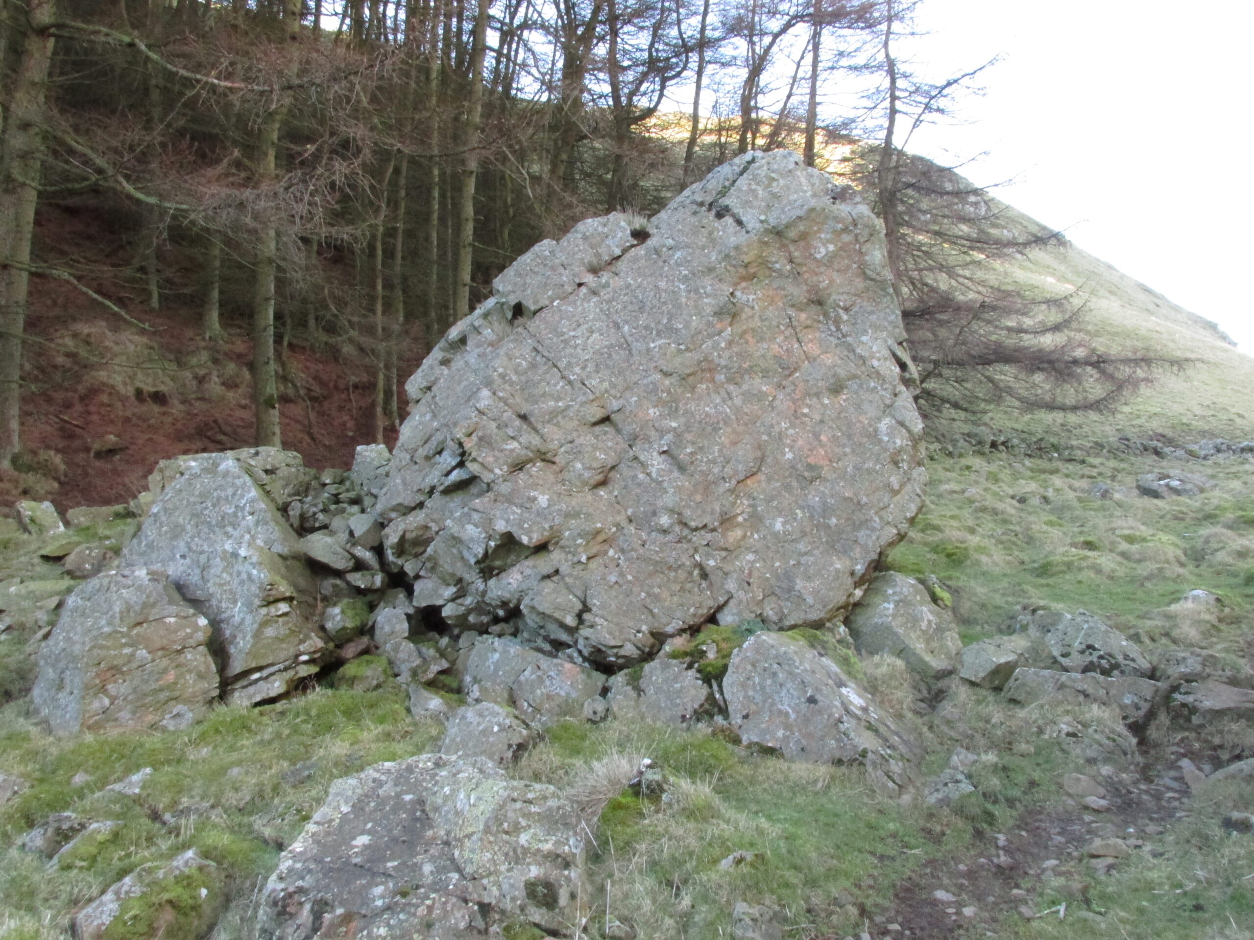
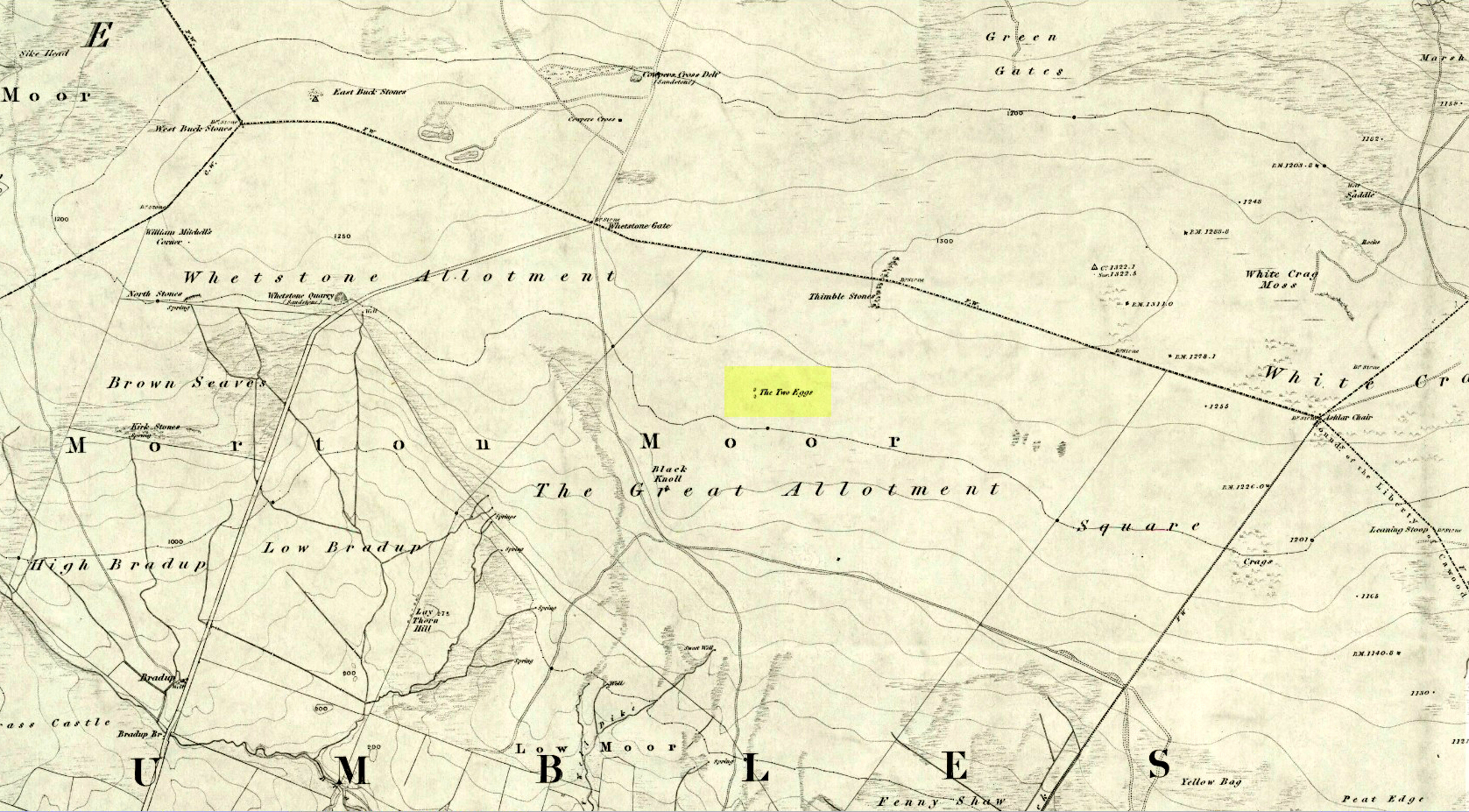
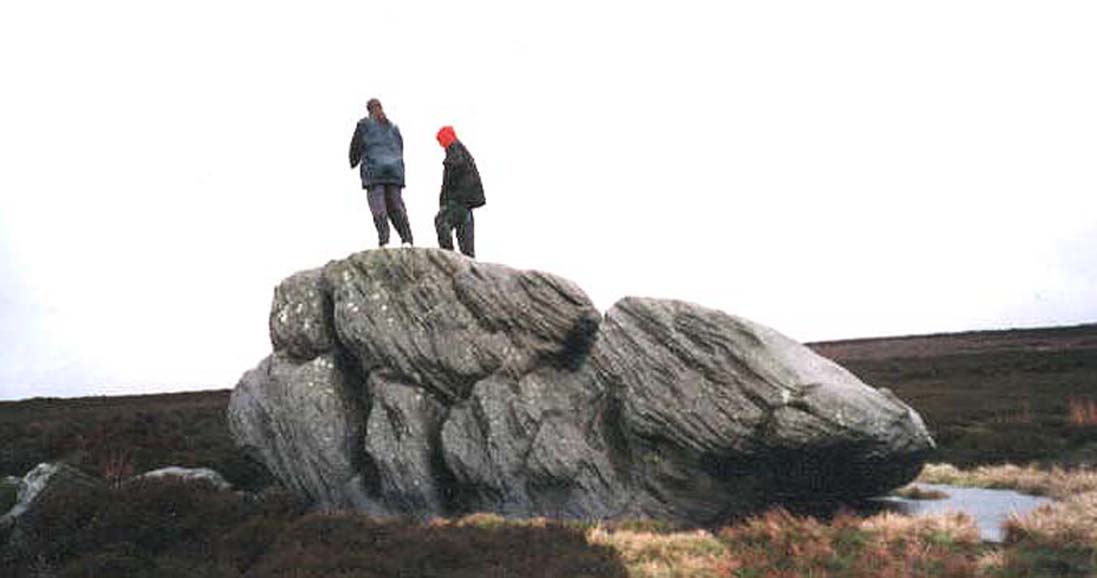
By whichever route you wanna take, get y’self to the prominent cup-and-ring marked rocks known as the Thimble Stones near the very top of these moors. From here, walk roughly 400 yards southwest onto the bare open moors (there are no footpaths here) and you’ll see these two isolated prominent boulders living quietly on their own. You can’t really miss ’em! You’re there.
Archaeology & History
Of the two giant boulders here, both are included in the petroglyph surveys of Hedges (1986) and Boughey & Vickerman’s (2003) as possessing “all natural” cup-marks on their top and vertical surfaces. Those on top of the rocks certainly seem to be Nature’s handiwork, whilst many of the seeming ‘cups’ on the vertical face of one (not the one pictured here) are due to gunshots. I’m not quite sure when they were done, but they certainly didn’t exist during the many visits I made here in the in the 1970s and ’80s.
They stones included in most of the standard antiquarian surveys of the 19th century, with the earliest being Forrest & Grainge (1869) who described them as,
“two detached masses of rock, standing alone upon the moor. The first is 14ft in length by 8ft in height, tapering to the ground; a set of cups and channels occupy the highest point. The other, distant 13 yards, is of an irregular square form, 45 yards in circumference and 7ft high. This stone appears to be tilted on its edge, presenting its cleavage upwards, and has hollows containing water, but is so much wasted above that if it has ever borne the cups and channels, they are now obliterated.”
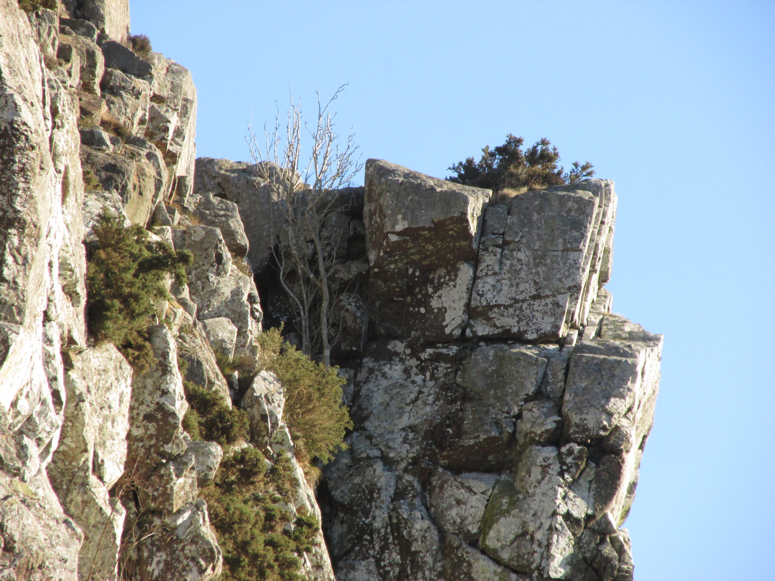
On top of an Egg, c.1986
Collyer & Turner (1885) described “a number of cups” on the edge of the northern rock; and Romilly Allen (1896) likewise. Even that historical literary giant, Harry Speight (1900), added his own tuppence here, telling folks how both Eggs “are channelled and bear cups.”
It’s very possible that these isolated stones did have some sort of significance to our prehistoric ancestors. There are innumerable examples worldwide of rocks like this possessing ritual and mythic lore—and many in the British Isles too. And the cupmarks on the stones may have been enhanced by those same prehistoric ancestors. But we’ll never know for sure…
Folklore
The creation myth behind the Two Eggs is one echoed in traditions across the world. Folklore tells that the Eggs were said to have been laid here by a great dragon who lived within a hill some distance to the south. All other aspects of the tale have sadly long since been forgotten…
References:
Allen, J. Romilly, “Cup and Ring Sculptures on Ilkley Moor,” in The Reliquary, volume 2, 1896.
Bennett, Paul, The Old Stones of Elmet, Capall Bann: Milverton 2001.
Boughey, Keith & Vickerman, E.A., Prehistoric Rock Art of the West Riding, WYAS: Wakefield 2003.
Collyer, Robert & Turner, J.H., Ilkley: Ancient and Modern, William Walker: Otley 1885.
Forrest, Charles & Grainge, William, A Ramble on Rombald’s Moor, Northern Antiquarian: Bradford 2012 (1st published 1867-69).
Hedges, John (ed.), The Carved Rocks on Rombalds Moor, WYMCC: Wakefield 1986.
Speight, Harry, Upper Wharfedale, Elliott Stock: London 1900.
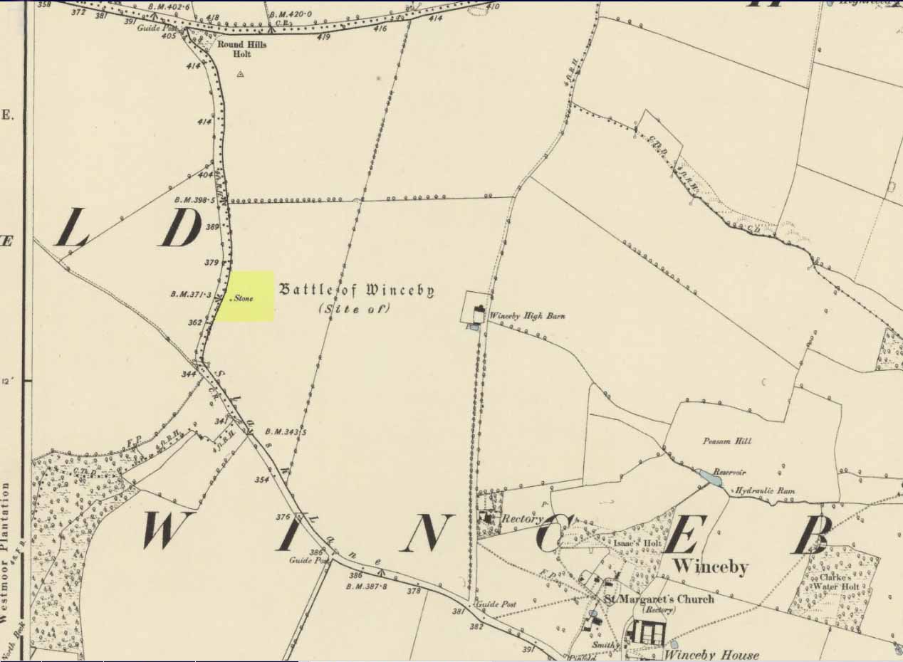
There is no specific archaeological information about this stone. However, we must take note of the so-called “devil’s footprint” that was on the boulder. In some parts of the UK, some devilish and other mythic footprints on stone are prehistoric cup-markings; but we have no idea whether this impression was such a carving or—more probably in this case—Nature’s handiwork. The field in which the stone existed was said to be the place where the so-called Battle of Winceby occurred.
Folklore
The stone was mentioned in several old tomes, with each one generally repeating the same familiar story, and with motifs that will be familiar to antiquarians and folklorists alike. In an early edition of Notes & Queries we were told of,
“the large stone in Winceby field, where soldiers had sharpened their swords before the battle. This was a stone of fearful interest, for much treasure was supposed to have been buried under it. Numerous attempts have been made to get at this treasure, but they were always defeated by some accident or piece of bad luck. On the last occasion, by ‘yokkin’ several horses to chains fastened round the stone, they nearly succeeded in pulling it over, when, in his excitement, one of the men uttered an oath, and the devil instantly appeared, and stamped on it with his foot. “Tha cheans all brok, tha osses fell, an’ tha stoan went back t’ its owd place solidder nur ivver; an’ if ya doan’t believe ya ma goa an’ look fur yer sen, an’ ya’ll see tha divvill’s fut mark like three kraws’ claws, a-top o’ tha stoan.’ It was firmly believed the lane was haunted, and that loud groans were often heard there.”
The tale was retold in Grange & Hudson’s (1891) essay on regional folklore. In Mr Walter’s (1904) excellent local history survey, there was an additional shape-shifting element to the story which, in more northern climes, is usually attributed to hare; but this was slightly different. The stone, as we’ve heard,
“was supposed to cover hidden treasure, and various attempts were made at different times to remove it, sometimes with six or even eight horses. At one of these attempts, his Satanic Majesty, having been invoked by the local title of ‘Old Lad’ appeared, it is said, in person, where upon the stone fell back, upsetting the horses. On another occasion a black mouse, probably the same Being incarnate in another form…ran over the gearing of the horses, with a similar result. Eventually, as a last resort, to break the spell, the boulder was buried, and now no trace of the boulder, black mouse, or Satan’s foot-print remains.”
Sadly we have no sketches of the devil’s ‘footprint’; and if local lore is right, we’ll never know. For tis said that a local farmer in the 1970s dug down and removed the stone completely. All that he found were numerous broken ploughshares around the rock, indicating that many tools had been used to shift the stone. In much more recent times however, a fellow antiquarian has said that it can still be found: so, if you can get a good photo of it, stick it on our Facebook group.
References:
Grange, Ernest L. & Hudson, J.C. (eds.), Lincolnshire Notes and Queries – volume 2, W.K. Morton: Horncastle 1891.
Gutch, Mrs & Peacock, Mabel, Examples of Printed Folklore Concerning Lincolnshire, David Nutt: London 1908.
Walter, J. Conway, Records, Historical and Antiquarian of Parishes around Horncastle, W.K. Morton: Horncastle 1904.
Acknowledgements:Huge thanks for use of the Ordnance Survey map in this site profile, reproduced with the kind permission of the National Library of Scotland.
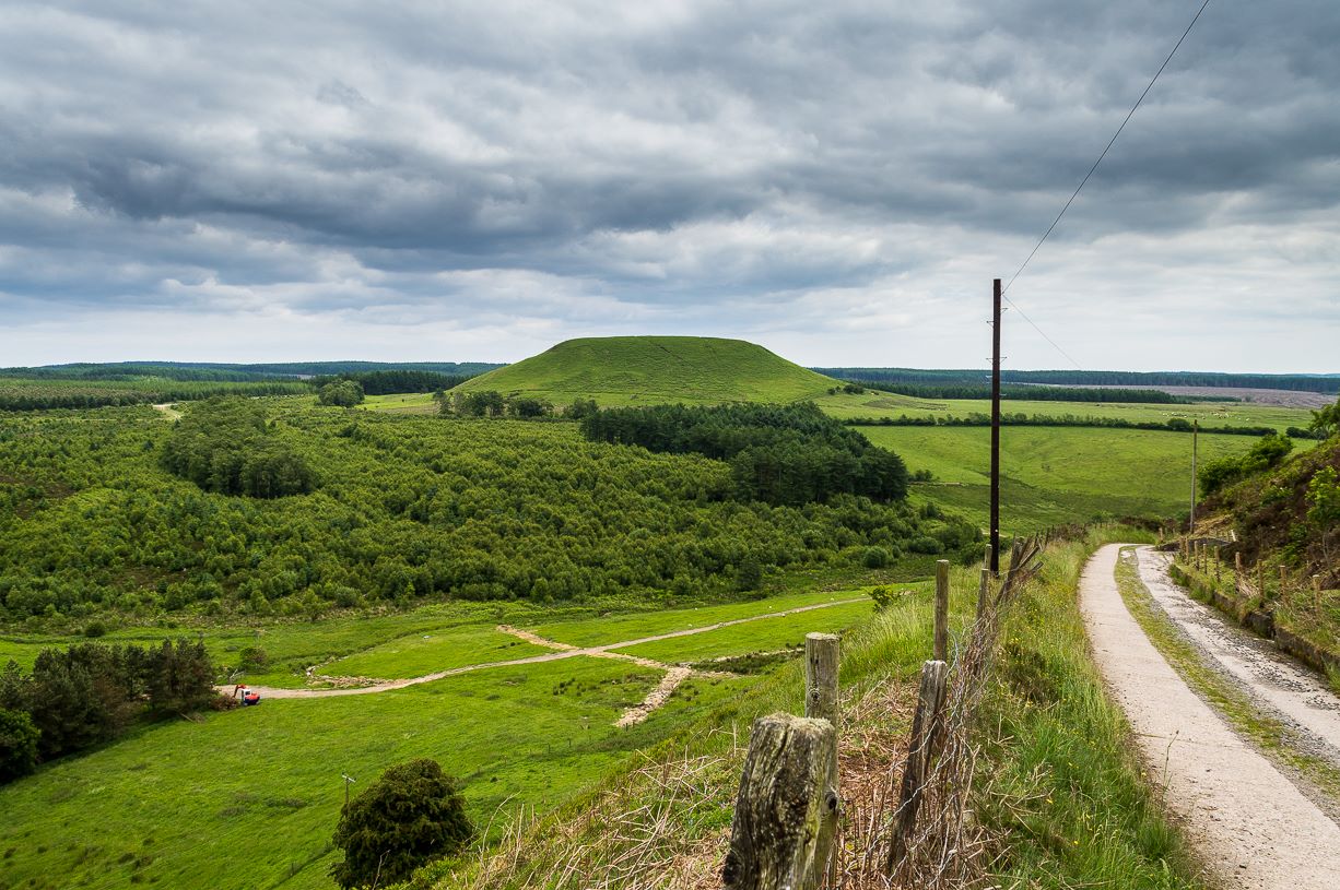
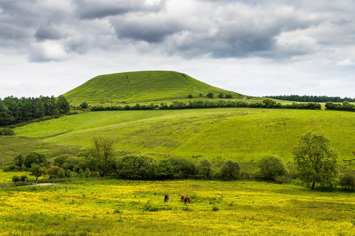
From Pickering, take the A169 towards Whitby. When you get to the Car Park at the ‘Hole-of-Horcum’ – (you can’t miss it), park the car and walk North along the side of the road towards Whitby. After 60 yds, take the track East. Follow this for approximately a mile until the track splits. Take the concrete track left towards the farmhouse of ‘Newgate Foot’. Go through the yard past the house on the right, and you will come to a stream and a gate and there, ahead of you, rises Blakey Topping…
Archaeology & History
The giant hill of Blakey Topping was recorded as early as 1233 CE and in a simplistic style just means the ‘black mound’; but this derivation has additional ingredients, implying it as a ‘black meeting-place’ or moot. Black in the etymological sense also implies ‘shining’ and it may also relate to the northern airt of black (meaning death, darkness, north, etc), when you’re stood at the ruined stone circle 400 yards to the south. But I’m speculating here…
Several 19th century antiquarians suggested there may have once been a cairn on top of the hill, but others who’ve explored this idea seem to have put it to bed.
Folklore
This great hill is well recognised amongst local people and, to this day, its animistic creation myths and other folklore elements are still spoken. When the photographer James Elkington recently visited the nearby standing stones, he bumped into the old farmer who told him how his father had seen the faerie-folk on the hill many years back. And its modern reputation as a gorgeous site adds to such lore, which dates way back.
In Frank & Harriett Elgee’s (1933) archaeology work, they narrated the old creation myth that local people used to tell of this great hill,
“A witch story related by a native 25 years ago attempts to explain two conspicuous natural features two miles apart on Pickering Moor; Blakey Topping, an isolated hill, and the Hole of Horcum, a deep basin-shaped valley. The local witch had sold her soul to the devil on the usual terms, but when he claimed it, she refused to give it up, and flew over the moors, with the devil in hot pursuit. Overtake her he could not, so he grabbed up a handful of earth and flung it at her. he missed his aim and she escaped. The Hole of Horcum remains to prove where he tore up the earth and Blakey Topping where it fell to the ground.
“From our point of view the significance of this story lies in the fact that between the Hole and the Topping there is a Bronze Age settlement site at Blakey Farm, with its stone circle. The rough trackway leading from the Hole to the circle is known as the Old Wife’s Way, presumably also marking the witch’s flight. This, together with other Old Wife’s Ways, preserves as it were Bronze Age church tracks”.
Looking up from the SW (James Elkington)
A relative variation on this tells that the Hole of Horcum was made by the local giant, Wade. He was having a row with his wife, Bell, and got so angry that he scooped out a lump of earth and threw it at her. The huge geological feature known as the Hole of Horcum is the dip left where he scooped out the earth, and Blakey topping, the clod itself, resting in situ where it landed. A christian appropriation of the story replaces Wade and his wife with their ‘devil’: a puerile element unworthy of serious consideration.
In more recent times, the old geomancer Guy Ragland Phillips (1976; 1985) found that a number of alignments, or leys (known as a ‘node’), centred on Blakey Topping: twelve in all, reaching out and crossing numerous holy wells, prehistoric tumuli, standing stones, etc. The precision of the alignments is questionable, yet the matter of the hill being a centre-point, or omphalos, would seem moreso than not.
References:
Elgee, F. & H.W., The Archaeology of Yorkshire, Methuen: London 1933.
Phillips, Guy Ragland, Brigantia, RKP: London 1976.
Phillips, Guy Ragland, The Unpolluted God, Northern Lights: Pocklington 1987.
Smith, A.H., The Place-Names of the North Riding of Yorkshire, Cambridge University Press 1928.
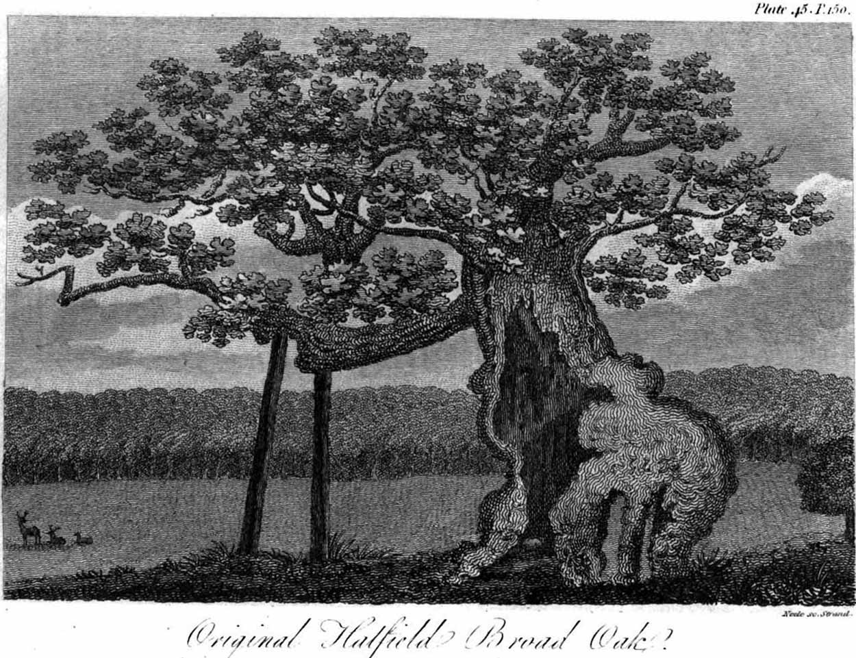
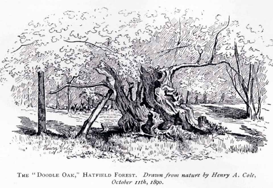
Erroneously ascribed by the reverend Winsland (1952) as being the ‘Doodle Oak’, the ancient and giant tree called the Broad Oak was, as records show, always known by this name, but was subsequently replaced by another after its demise. It was this second tree that became known as the Doodle Oak. Winsland described it as “an immense and famous oak tree”, under whose “spreading branches in olden days the Lord of the Manor probably held his court and dispensed justice.”
The tree was described as early as 1136 AD and was probably an early tribal meeting site, or moot spot. In Philip Morant’s (1763) work, he described it as,
“A tree of extraordinary bigness. There has been another since…called Doodle Oak.”
The old Oak in 1890
The Doodle Oak was thought to date from around 10-11th century and its predecessor may have been upwards of a thousand years old before this one took its place. In 1949, one patient botanist, Maynard Greville, investigated the Doodle Oak tree-rings and found it to be 850 years old. Other estimates suggest it was a hundred years older than that! Whichever was the correct one, a measurement of its trunk found it to be some 19 yards in circumference – one of the largest trees ever recorded in Britain!
Sketches of its dying body were thankfully made near the beginning and the end of the 19th century: one in Mr Vancouver’s (1807) Agriculture of Essex, and the other by Henry Cole of the Essex Naturalist journal.
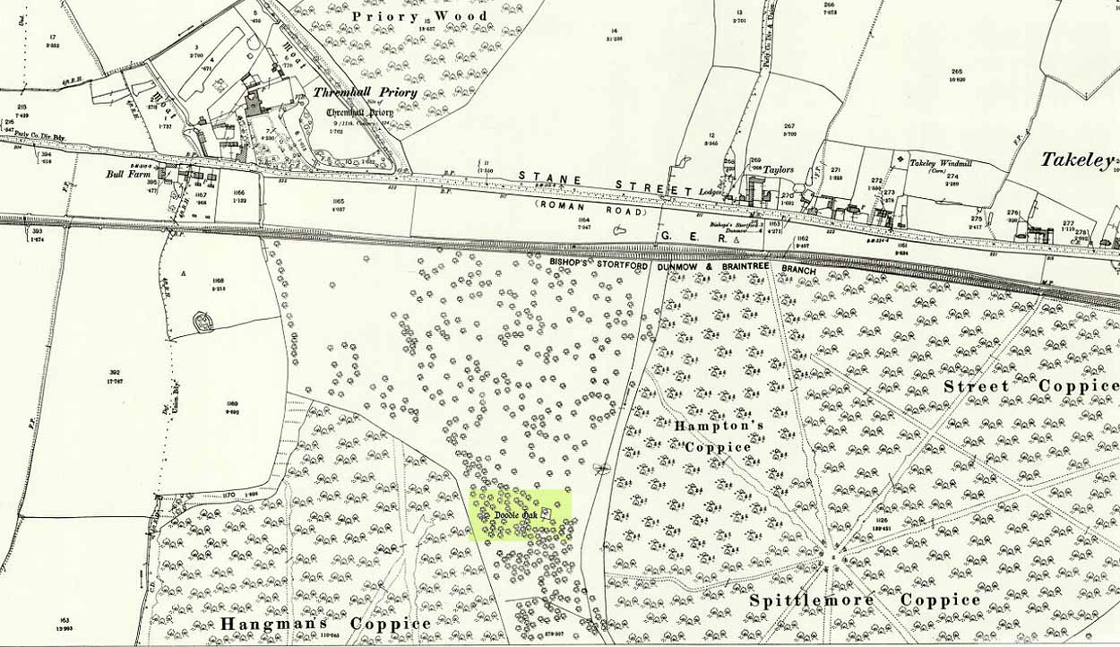
Doodle Oak on 1896 map
Some speculate that the Broad Oak of ancient times and the subsequent Doodle Oak were at very different places in the parish, but without hard evidence this idea is purely hypothetical. And whilst the name ‘broad’ oak is easily explained, the name ‘doodle’ is slightly more troublesome. However, a seemingly likely etymology is found in the Essex dialect word dool, which Edward Gepp (1920) told,
“seems to mean, (1) a landmark; (2) a path between plots in a common field.”
The former of the two would seem to be the most likely. This is echoed to a greater degree in Wright’s (1900) magnum opus, where he found the dialect word dool all over the southeast, meaning,
“a boundary mark in an unenclosed field.”
Giant trees on ancient boundaries, like the Broad Oak of earlier times, would seem to be the most probable reason for its name. Today, all that’s left of the site is a small plaque on a small tree-stump, telling us what once stood here…
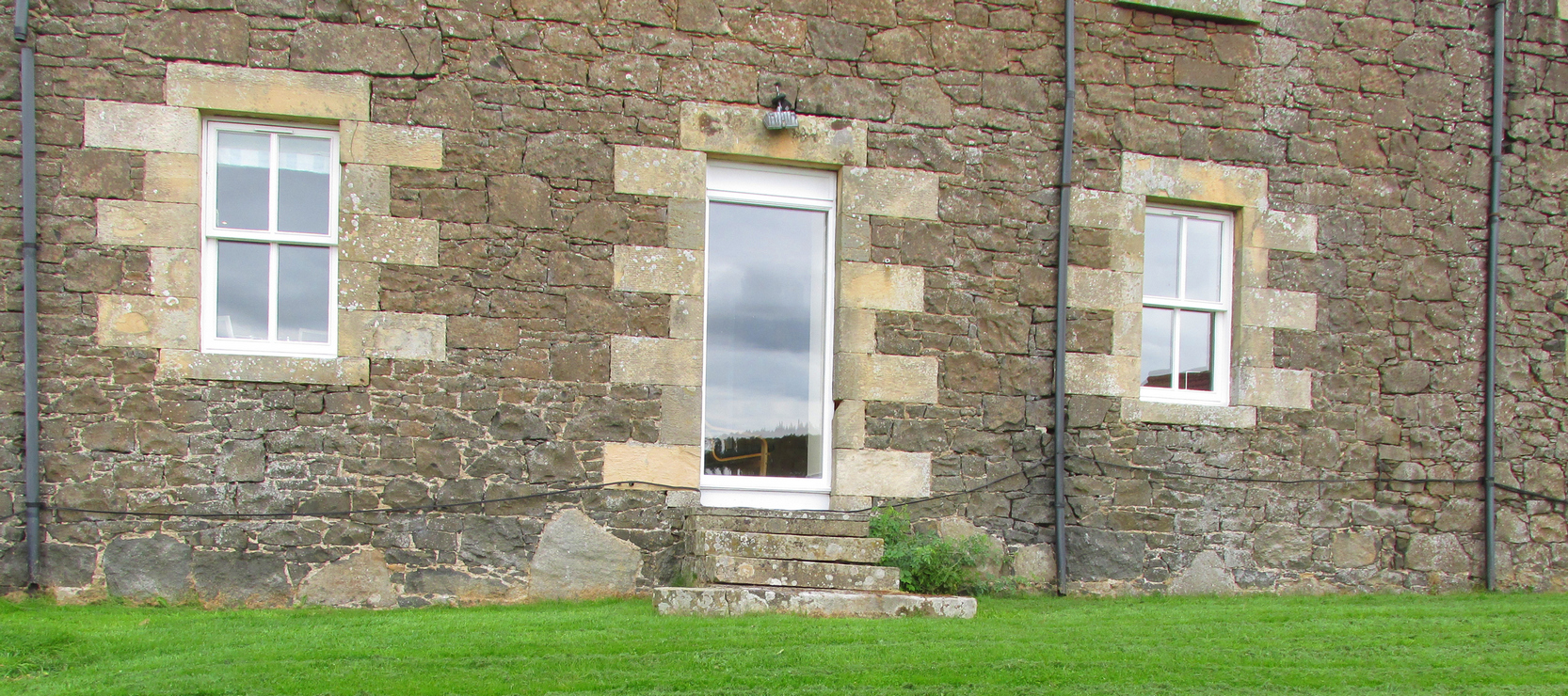
Travelling South along the A916 just past Craigrothie, turn right down to Chance Inn, and turn left at the T junction. and follow the road on to just past the left hand bend when Waltonhill Farm will be seen on the right. The Stones form part of the structure of a dwelling house and are not accessible to the public, but are visible from the public highway further down the road as the light coloured irregular shaped stones at ground level either side of the door of the south-facing house.
Archaeology & History
According to a piece published in the Fife Herald & Journal in 1905:-
“Once upon a time, so runs the legend, Samson challenged the devil to match him at boulder throwing. As challenger, Samson stood on the West Lomond; Satan stood on the East. The signal was given; two mighty rocks whistled through the air. ‘The De’ils Stane‘ fell where it now lies, on the road-side about a quarter of a mile west from Waltonhill Farm. Samson, though handicapped by three miles greater distance, flung his stone fully four hundred yards beyond that of Satan, and with such force that it split into three parts; which parts are now built into Waltonhill barn.”
The light-coloured stones at ground level are the likely remainsAnother view of the stones
This is of course a variant of a creation myth that is to be found throughout Britain, of an Age of Giants who strode the land quarrelling with each other and the mortal humans. The original names of the Giants have been lost in the aeons of oral transmission of the legend from pre-history, and replaced by that of a probably equally legendary Middle Eastern strong man from the Christian’s Bible, in combat with the Christian’s Naughty Man. And to prove the point of Christianity’s superiority over the old animistic cults of the land, the De’il has to be demonstrably the Loser.
The house owner told me that what is now the farmhouse bearing the stones, was originally the barn, that they rebuilt after 40 years of dereliction, and interestingly she had heard something about some Samson’s Stones, but not about the nearby De’il’s Stane, which shows that these ancient legends are still being orally transmitted.
The stone was thrown over 10 miles from West Lomond (right)
There are five ‘odd’ stones either side of the doorway, along the base of the wall facing the Lomond Hills, of irregular shape and lighter colour than the rest of the building’s walls. These are the likely candidates for the Samson’s Stones (unless anyone can come up with more convincing evidence). While the legend speaks of three stones, it is quite feasible that the masons dressed these when they built the original barn, making five stones out of the three. They look like they may be successive horizontal slices of a larger square to triangular sectioned stone. Pure speculation on the writer’s part, but are these the remains of a lost standing stone(s) that had to be demolished in order for the barn to be built, pieces of which were incorporated into the building to give the original stone’s magical protection to the farmer’s animals and crops?
References:
Fife Herald & Journal, 1st November 1905, quoted in John Ewart Simpkins’ County Folklore – Volume VII: Fife, with some notes concerning Clackmannan and Kinross-shires, Folk-Lore Society by Sidgwick& Jackson: London 1914.
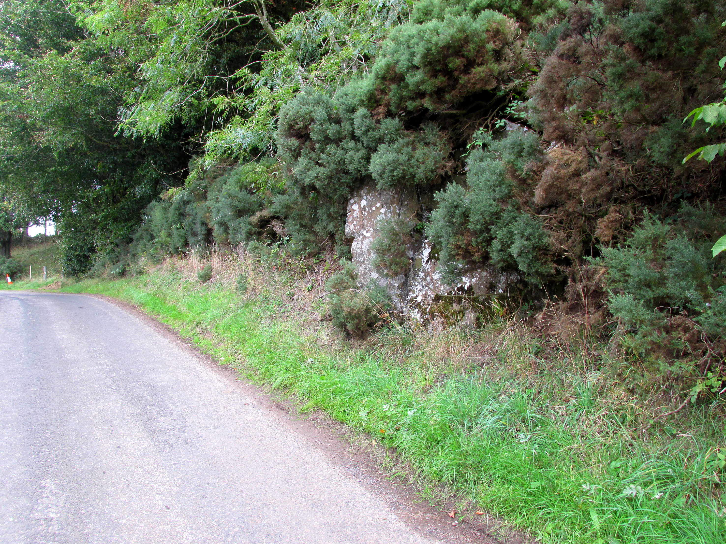
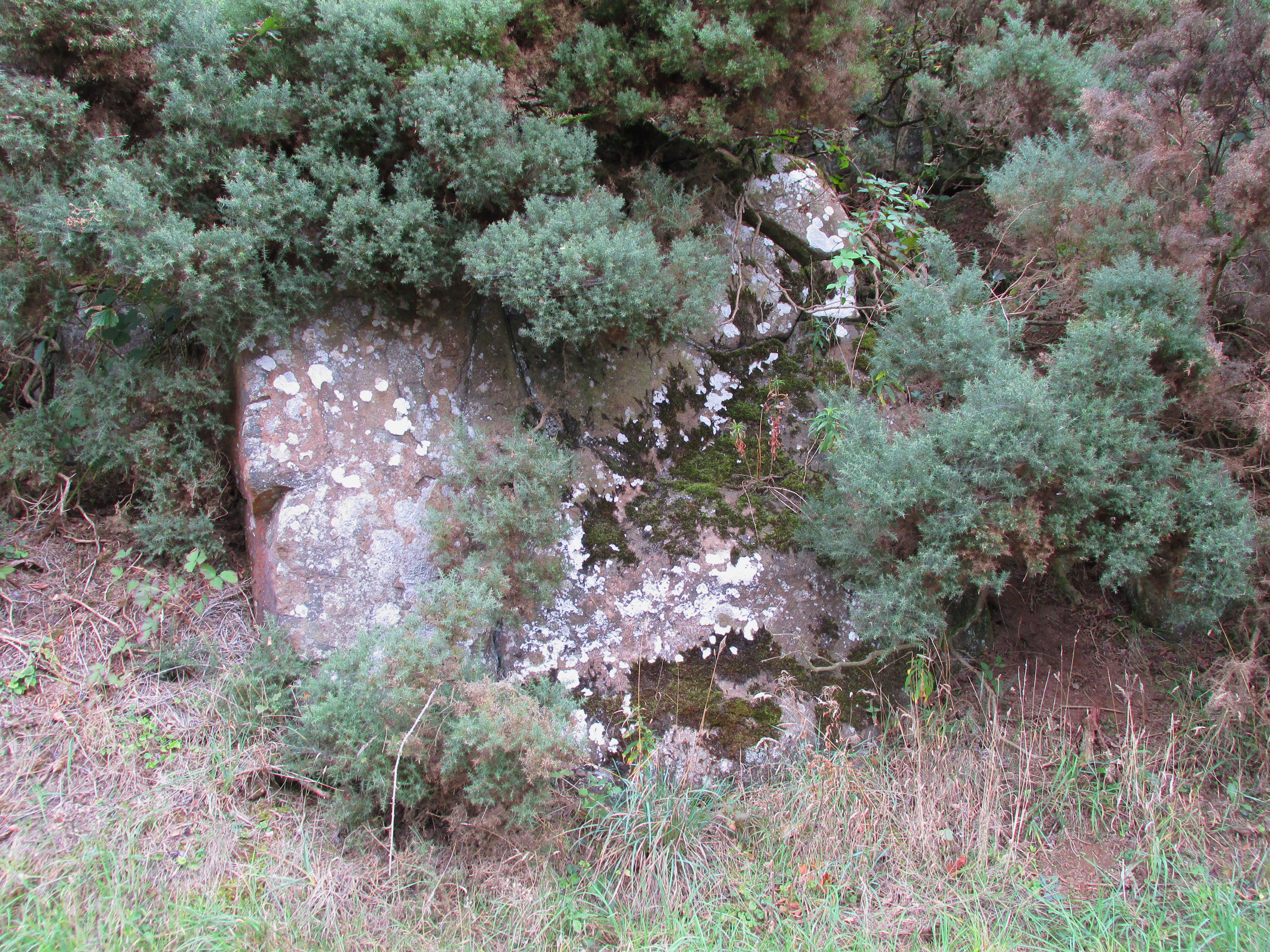
Travelling South along the A916 just past Craigrothie, turn right down to Chance Inn, and turn left at the T junction. and follow the road on to just past the left hand bend when Waltonhill Farm will be seen on the right. Continue south down the road a few hundred yards until it takes a slight right turn. The De’il’s Stane, a huge flat faced slab of rock, will be seen at the roadside on the left side of the road, partly obscured by gorse.
Archaeology & History
According to a piece published in the Fife Herald & Journal in 1905:-
“Once upon a time, so runs the legend, Samson challenged the devil to match him at boulder throwing. As challenger, Samson stood on the West Lomond; Satan stood on the East. The signal was given; two mighty rocks whistled through the air. ‘The De’ils Stane’ fell where it now lies, on the road-side about a quarter of a mile west [sic] from Waltonhill Farm. Samson, though handicapped by three miles greater distance, flung his stone fully four hundred yards beyond that of Satan, and with such force that it split into three parts; which parts are now built into Waltonhill barn”.
The roadside location, just south of the bend
The De’il’s Stane, a huge slab of rock!
This is of course a variant of a creation myth that is to be found throughout Britain, of an Age of Giants who hurled rocks around and strode the land quarrelling with each other and the mortal humans . The original names of the Waltonhill Giants have been lost in the aeons of oral transmission of the legend from pre-history, and replaced by that of a probably equally legendary Middle Eastern strong man from the Christian’s Bible, in combat with the Christian’s Naughty Man. And this was of course done to prove the point of Christianity’s superiority over the old animistic cults of the land, and the De’il had to be demonstrably the loser.
De’ils Stane thrown by the Man in the Red Velvet Suit from East Lomond (Left)
Owing to the Stone being partly hidden by gorse, it was not possible to make a close inspection of the rock for carvings etc. A further visit will no doubt be made to try to clear some of the gorse so a closer inspection can be made. The Stone’s size (approximately 15′ high by 20′ wide by 4′ thick) and the way it is resting against a natural bank, does give a credence to the legend of its having been slung by a giant from East Lomond, clearly visible nearly 7¾ miles away.
Reference:
Fife Herald & Journal, 1st November 1905, quoted in John Ewart Simpkins’ County Folklore – Volume VII: Fife, with some notes concerning Clackmannan and Kinross-shires, Folk-Lore Society by Sidgwick& Jackson: London 1914.
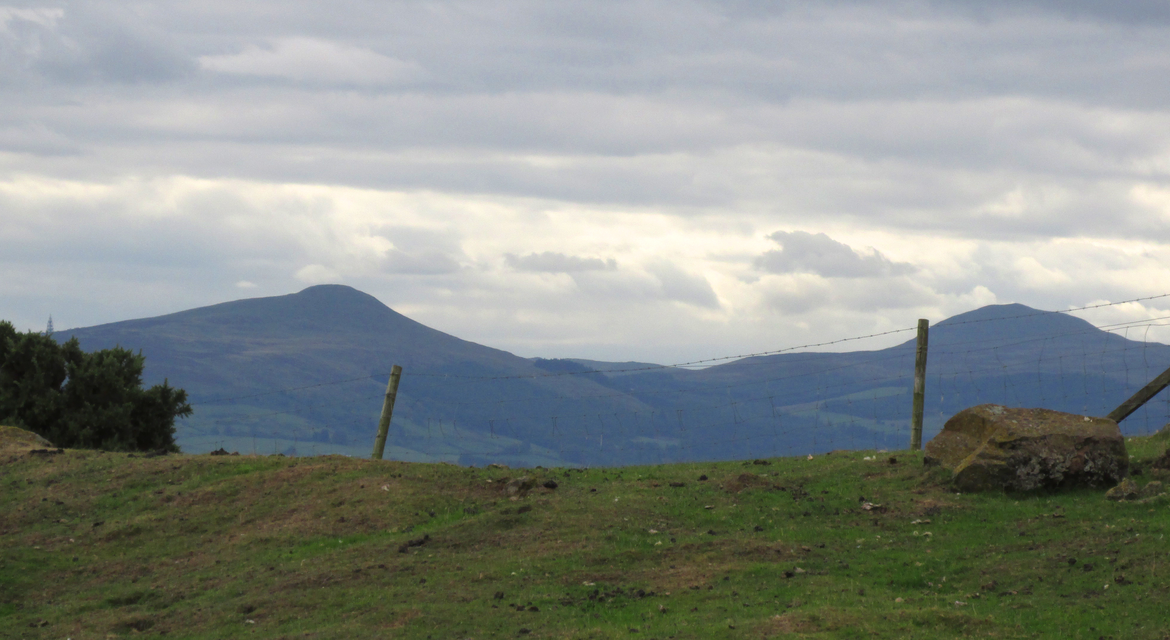
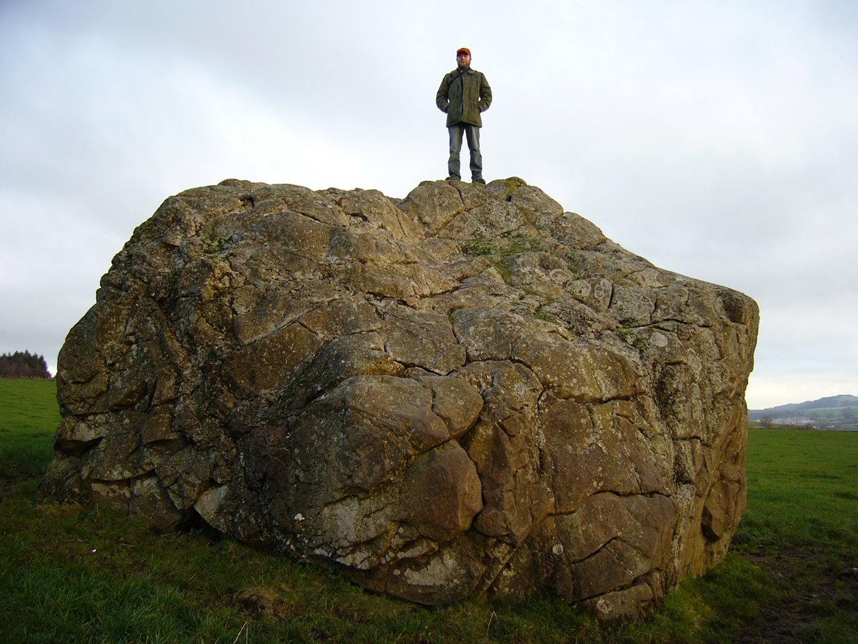
On the outer southern edge of Kilbarchan parish—right near the ancient boundary line itself—this giant stone of the druids is seems to be well-known by local folk. Located about 40 yards away from the sacred ‘St Bride’s Burn’ (her ‘Well’ is several hundred yards to the west), it was known to have been a rocking stone in early traditions, but as Glaswegian antiquarian Frank Mercer told us, “the stone no longer moves.” The creation myths underscoring its existence, as Robert Mackenzie (1902) told us, say
“This remarkable stone, thought by some to have been set up by the druids, and by others to have been carried hither by a glacier, is now believed to be the top of a buried lava cone rising through lavas of different kind.”
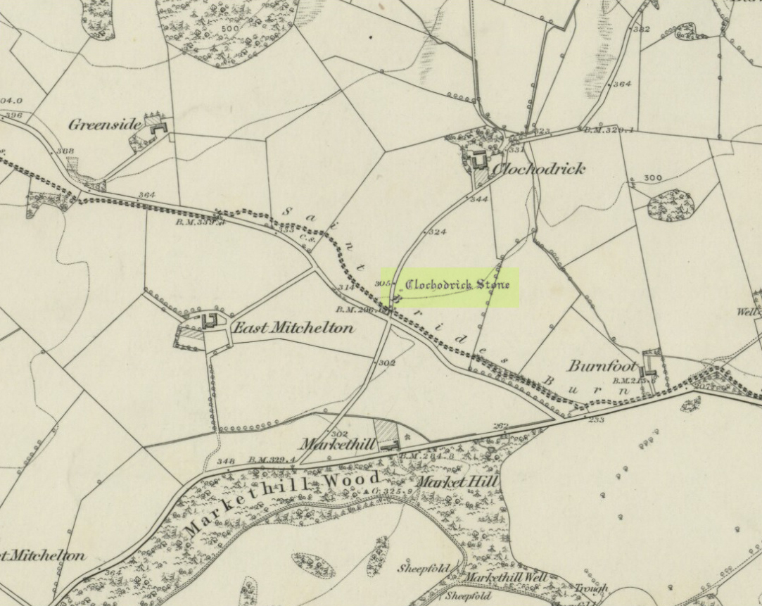
Clochoderick Stone on 1857 map
The site was highlighted on the first OS-map of the area in 1857, but the earliest mention of it seems to be as far back as 1204 CE, where it was named as Clochrodric and variants on that title several times in the 13th century. It was suggested by the old place-name student, Sir H. Maxwell, to derive from ‘the Stone of Ryderch’, who was the ruler of Strathclyde in the 6th century. He may be right.
Folklore
Folklore told that this stone was not only the place where the druids held office and dispensed justice, but that it was also the burial-place of the Strathclyde King, Ryderch Hael.
References:
Campsie, Alison, “Scotland’s Mysterious Rocking Stones,” in The Scotsman, 17 August, 2017.
MacKenzie, Robert D., Kilbarchan: A Parish History, Alexander Gardner: Paisley 1902.
Acknowledgements: Big thanks to Frank Mercer for use of his photos and catalytic inception for this site profile.