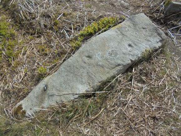
Take the same directions as if you’re going to visit the Naked Jogger Carving (stone 612), not far from the well-known Tree of Life Stone. From the Naked Jogger carving, walk up the small outcrop of rocks that bends above you. Barely 100 yards up when you reach the top, you’ll notice a single large sloping stone barely 50 yards ahead of you in the same field. That’s the spot!
Archaeology & History
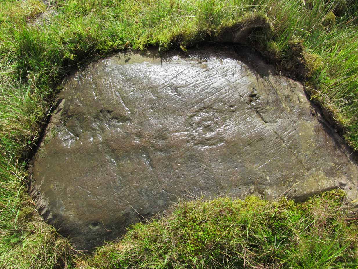
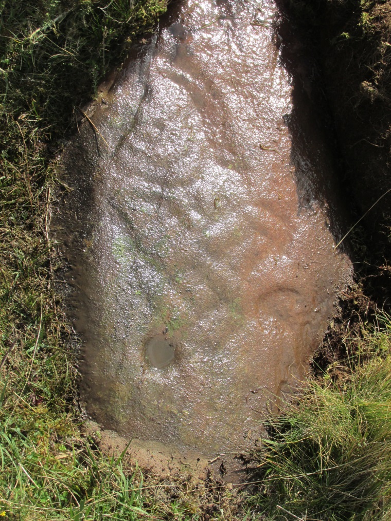
This is a little-known beauty of a carving just off the edge of the quiet moors that are littered with prehistoric remains. It was only rediscovered a few years ago — by myself if you believe the writings of rock art student Keith Boughey (2010) in his essay on the validity of so-called “amateurs”who research and discover petroglyphs (Boughey’s essay is scattered with mistakes). But I’d never even visited this carving until two years ago! The stone was in fact found during a field-walk by early members of the Northern Earth Mysteries group in August 1989 (Wilson 1990) and subsequently described and illustrated for the first time by Phil Reeder (1990).
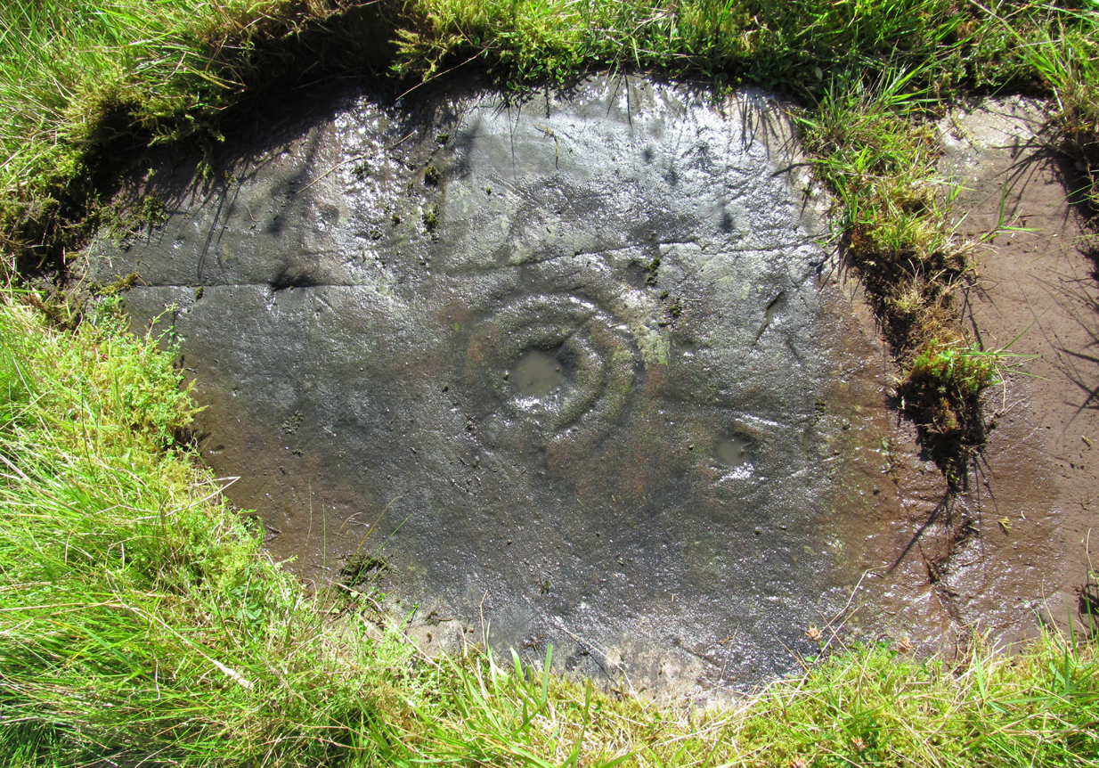
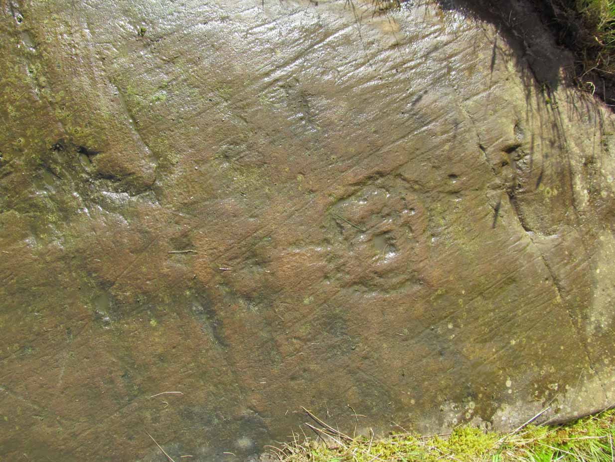
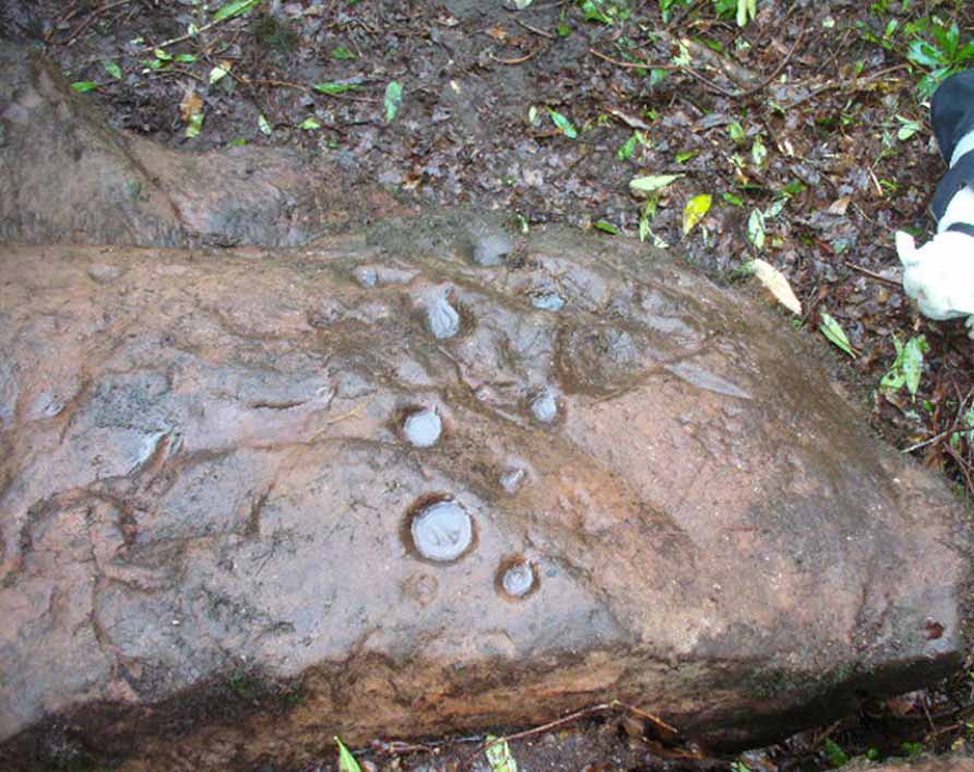
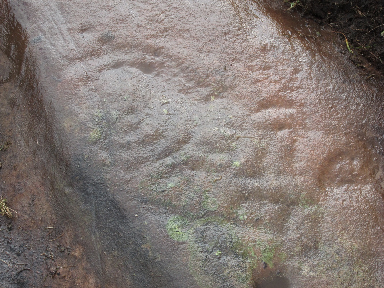
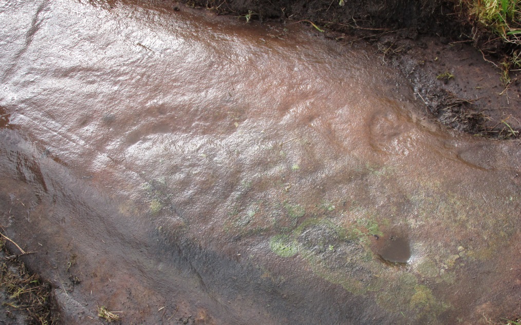
Close-up of main cluster
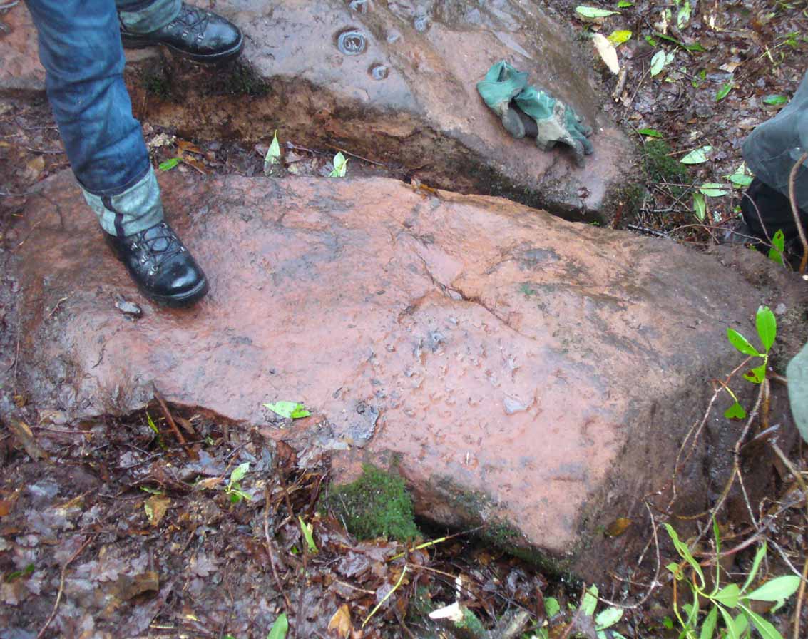
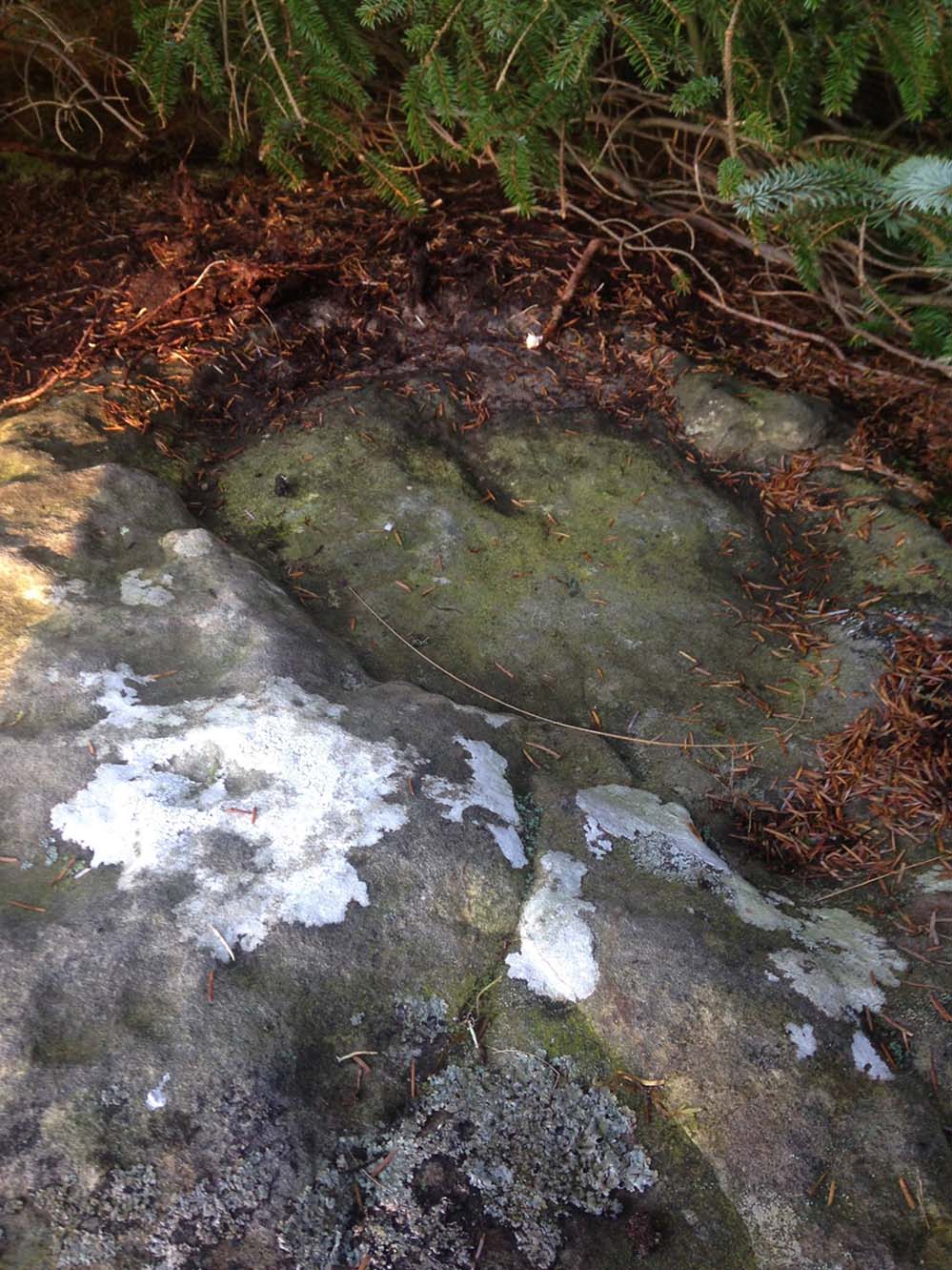
As can be seen in the photos accompanying this site profile, the rock on which the carving has been done has, at some point in the past, been cut into and its edges have been hacked away and destroyed, literally cutting into the overall design. We have no idea what the original size of the stone was, obviously, but this petroglyph was once larger than the design that we see at present. Such is the price of ‘progress’, as some folk call it.
Anyway – a few months after the carving was rediscovered, Phil Reeder (1990) wrote:
“After a visit to the Tree of Life stone…a cursory inspection by the NEM Group was made on nearby rock outcrops, part of which showed evidence of recent exposure due to soil erosion.
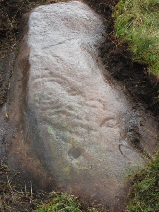
“One stone in particular stood out as five shallow cups and associated rings could be discerned. When cleaned, it became apparent that further carvings extended beneath a thin eroding soil layer. When this layer was cleared, a complex set of carvings were revealed.
“Only preliminary work at the site has been carried out to date, but it appears that the carvings comprise of at least 28 cups, 13 of which have associated rings; several of the cups are linked by gutters forming an intricate design, one gutter part enclosing 11 cups. The carvings on the lower edge of the stone have weathered badly and are difficult to interpret.”
Reeder’s so-called “amateur” description is a good one. Certainly more accurate than the subsequent one by Boughey (“I’m a professional”) & Vickerman (2003):
“Large rock of coarse grit whose surface slopes with the hill. About forty cups, some large, many with single rings, and many curving grooves, the whole forming a remarkable, complex design.”
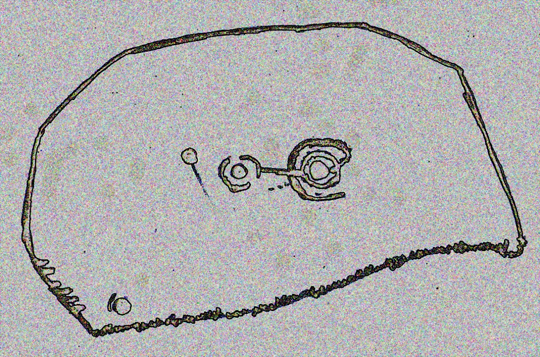
Phil Reeder’s 1990 drawing
Boughey & Vickerman’s sketch
We can see in the respective drawings by both Reeder (left) and Boughey & Vickerman (right) that some elements which should have been included in the ‘official’ drawing were missed, yet had been accurately included in the earlier ‘preliminary’ drawing, as Mr Reeder put it. I hope that readers will forgive me pointing out these seemingly minor elements; but I do it to illustrate the ineffectiveness of more recent rock art students who are gaining the title of ‘experts’ in this field. It’s important to recognise that, in this field of study, “experts” are few and far between indeed… I’ve certainly yet to meet any!
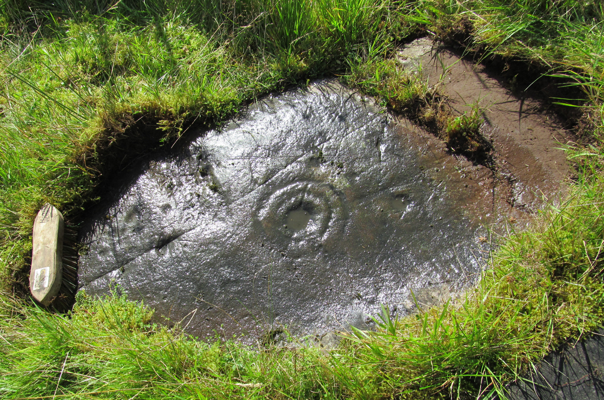
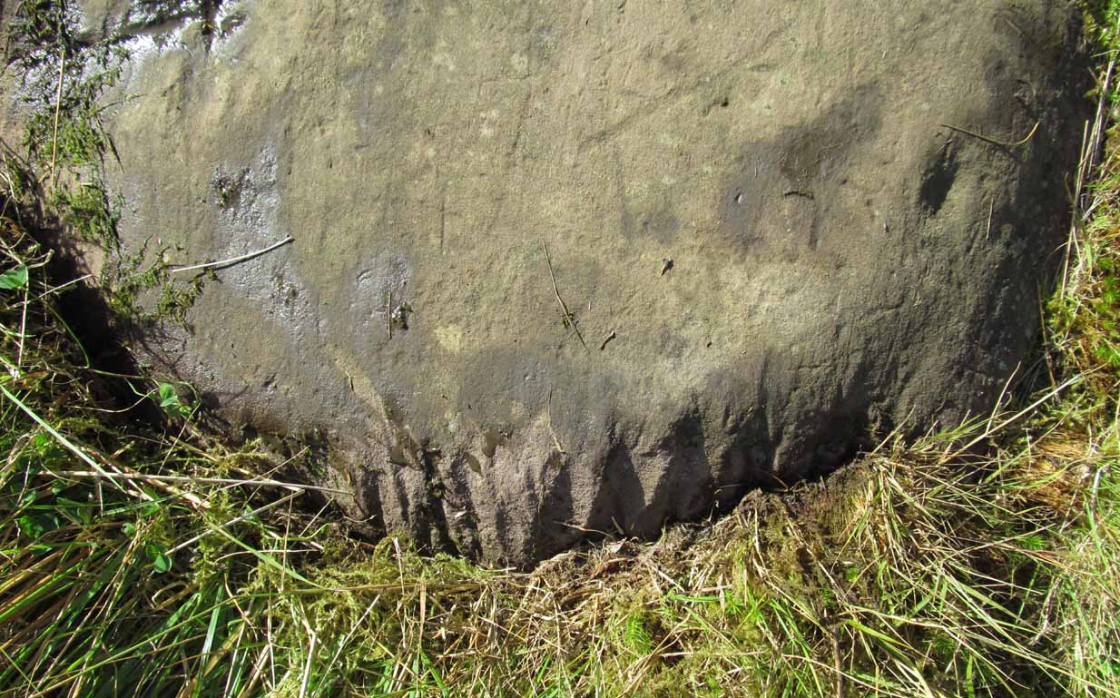
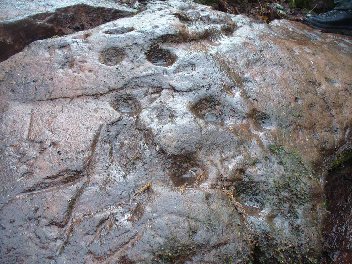
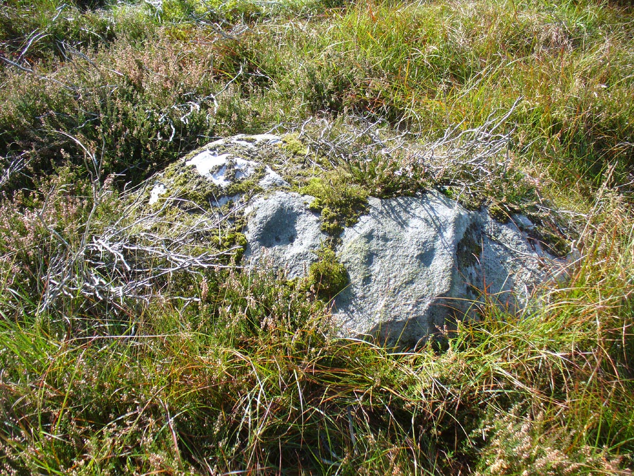
Northern end of carving
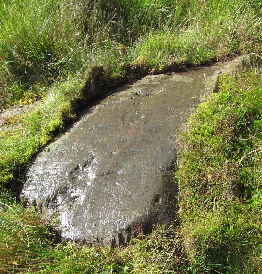
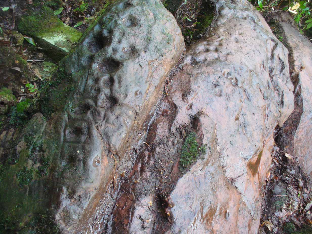
Southern side of carving
The carving is mentioned briefly in Beckensall’s (1999) introductory study, with little comment. But of note here is not only the curious linear feature running between two cup-and-rings, but the position of the stone in the landscape. For if you sit either upon or next to this carving, you are looking east straight across the gorgeous Fewston valley directly at the prominent wooded hill of Sword Point. As it slopes down into the present-day greenery of fields and scattered woods, the Wharfe Valley spreads out to the distant east and, as the sun rises and scatters its rays onto the wet morning stone here, the design on the rock awakens with much greater visual lucidity than that which our daytime eyes bestow to us. In all likelihood, sunrise was an important element in whatever mythic function underscored this curious carving, with its human-like figure rising on its southern side, emerging from the edge of the rock, personifying perhaps the rising solar disc and the living landscape as the daylight breath awoke Earth’s creatures; or maybe it signifies a symbolic group of people gathered together watching the sunrise…
Of course, I’m dreaming… (how very amateur of me! 🙂 )
References:
Barnett, T. & Sharpe, K. (eds.), Carving a Future for British Rock Art, Oxbow: Oxford 2010.
Beckensall, Stan, British Prehistoric Rock Art, Tempus: Stroud 1999.
Boughey, Keith, “The Role of the Amateur in the Study of UK Prehistoric Cup-and-Ring Art,” in Barnett & Sharpe, Oxford 2010.
Boughey, Keith & Vickerman, E.A., Prehistoric Rock Art of the West Riding, WYAS: Leeds 2003.
Chappell, Graeme, “North Yorkshire Rock Art – New Discoveries,” in Northern Earth, no.62, 1995.
Michell, John, The Earth Spirit, Thames & Hudson: London 1975.
Reeder, Phil, “Snowden Carr Rock Carvings,” in Northern Earth Mysteries, no.40, 1990.
Cup-and-rings on gatepost (photo credit, Dave Whittaker)
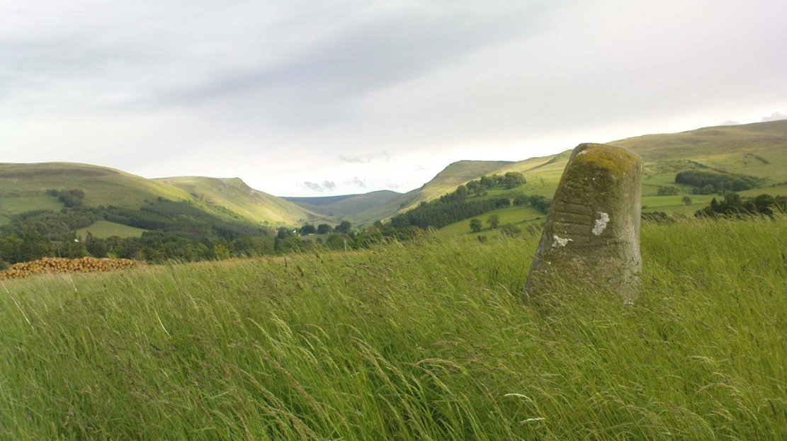
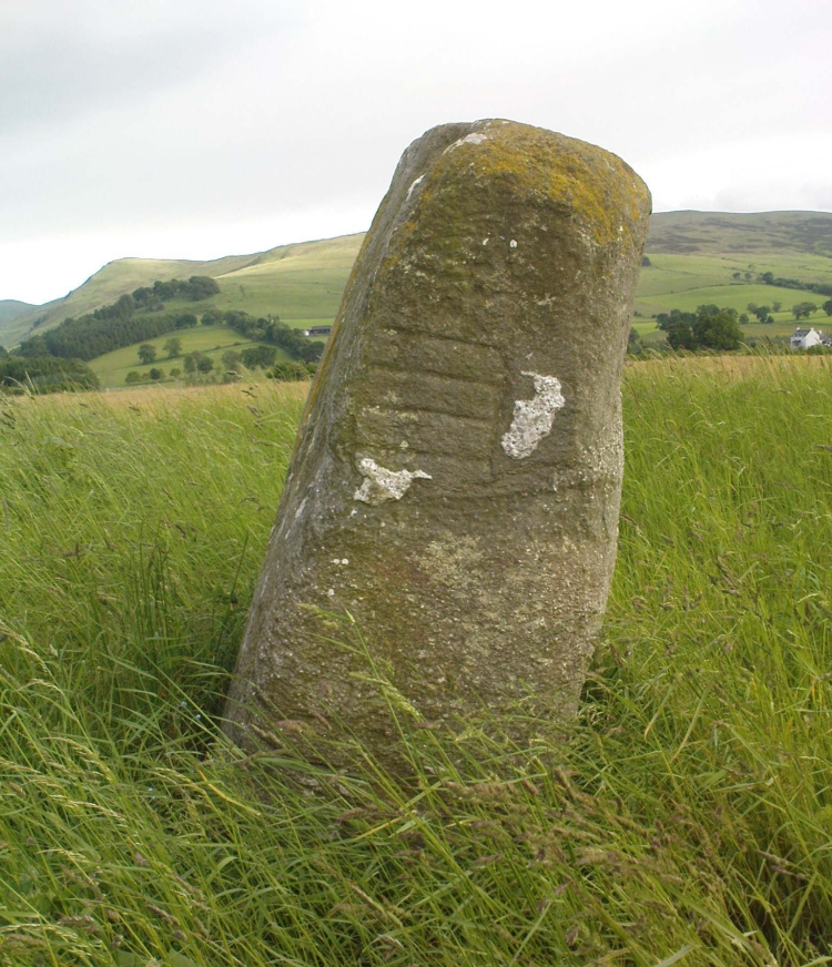
From Ilkley, follow the same directions as if you’re going up to the superb Swastika Stone. Keep walking on the footpath, west, for 65 yards (59m), then walk into the heather on your left. Barely 5 yards in, you’ll see this fallen standing stone or gatepost.
Archaeology & History
First described in one of Stuart Feather’s (1964) old rambles, I first saw this stone in my late-teens and was as puzzled by it then as I am today. Upon an obviously worked stone that may once have stood upright (or was intended to do), two faint and incomplete cup-and-rings were carved – but when exactly? If this stone was cut from a larger rock into its present shape, were the petroglyphs already on it, or were they done when the ‘gatepost’ was created?
It was first described in one of Stuart Feather’s (1964) rambles up here and later included in Hedges’ (1986) survey, where he told it to be a, “recumbent gatepost with one cup with almost complete ring and one cup with vestigial ring.” Boughey & Vickerman’s (2003) survey added little more. And when a group calling itself Carved Stones Investigation got itself about £250,000 to “investigate” the Ilkley petroglyphs, I was hoping that they could have at least turned this stone over to see if other carvings were on the stone – but they just revisited all those found by others, made a new list, and took the money to be honest (no website and no book – as they should’ve done). Thankfully, local folk are having a look at this and others and doing the work they should have. Check it out when you’re next up at the Swastika.
References:
Bennett, Paul, Megalithic Ramblings between Ilkley and Baildon, unpublished: Shipley 1982.
Boughey, Keith & Vickerman, E.A., Prehistoric Rock Art of the West Riding, WYAS: Wakefield 2003.
Feather, Stuart, “Mid-Wharfedale Cup-and-Ring Markings: no.26, 27, 28 – Black Pots, High Moor, Silsden, near Keighley,” in Cartwright Hall Archaeology Group Bulletin, 9:10, 1964.
Hedges, John, The Carved Rocks on Rombalds Moor, WYMCC: Wakefield 1986.
Acknowledgements: Huge thanks to Dave Whittaker for the photo. Good luck with the plans fellas.
Along the A81 road from Port of Menteith to Aberfoyle, watch out for the small road in the trees running at an angle sharply uphill, nearly opposite Portend, up to Coldon and higher. Keep going, bearing right past Mondowie and stopping at the dirt-track 100 yards or so further up on the left. Walk up this dirt-track for ⅔ mile, and just before reaching the planted forestry, turn right along another dirt-track. Less than 200 yards along there’s a large sycamore tree, and about 20 yards below it (south) are several open flat rock surfaces. This is the most westerly of them.
Archaeology & History
…and again
On this small smooth rock surface we find an almost archetypal cup-and-ring stone, whose design consists of a double cup-and-ring and a faint cup-and-ring. The double-ring has several seemingly natural small fissures in the rock running at various angles into the central cup from the outside; and there are two faint ones running from the double-rings outwards to the cup-mark in the single-ring, framing the central cupmark in the middle. It may have been that these scratches on the rock gave rise to the position of the cupmark in this petroglyph. It’s difficult to see whether or not the single cup-and-ring was ever completed.
Canmore’s description of this petroglyph tells simply: “The larger of the two is 180mm in diameter and has two rings around a cup that is 70mm in diameter and 15mm deep. The smaller has one ring around a cup.”
Once you’ve seen this, have a look at the Over Glenny (6) carving, about 10 yards east of here.
Along the A81 road from Port of Menteith to Aberfoyle, watch out for the small road in the trees running at an angle sharply uphill, nearly opposite Portend, up to Coldon and higher. Keep going, bearing right past Mondowie and stopping at the dirt-track 100 yards or so further up on the left (and ignore the english fuckers up here who might say “you’re not allowed to park here”, as Scottish government regulation allows you to do so unless you block the road). Walk up this dirt-track for ⅔ mile, and just before reaching the planted forestry, turn right along another dirt-track. Less than 200 yards along there’s a large sycamore tree, and about 20 yards below it (south) is the carving you’re looking for.
Archaeology & History
It’s difficult keeping up with the carvings in this region to the north of the Lake of Menteith, as we find new unrecorded ones on every visit, maintaining the tradition of fellow rock art students Maarten van Hoek, Kaledon Naddair, George Currie, Jan Broewer and the rest—and we know that there’s more of them hidden away. This one doesn’t seem to be in the Canmore listings, but I put that down to the fact that they’ve got a grid-reference wrong somewhere, as it’s pretty plain to see. Although, to be honest, in the rather vague descriptions of other adjacent carvings (Over Glenny 5 and 7), this carving is in-between them, so you’d expect it to be listed. Anyway, that aside…
Looking down at the ringsClose-up of faint rings
This long flat exposed rock surface has two primary cup-and-rings upon it: one cup with a double-ring, and the other standard cup-and-ring; there are also two single cup-markings on the stone: one near the middle of the rock and the other on its lower-right side. The main element is the double-cup-and-ring, which appears to be incomplete—not only in terms of its design, but also, as you can see in the photos, seems unfinished. From the central double-ring, a faint carved line runs out from the centre and into the other faint, incomplete, single cup-and-ring.
Series of metal-sharpening groovesArty-farty sketch of the design
At the bottom of the stone (as with several others hereby) a curious set of deep scars have been cut into the edge of the rock. They’re unmistakable when you see them. They have probably been created by metal artifacts being sharpened along the bottom of the rock—many many times by the look of it. These deep cuts reminded me of the more famous Polisher Stone, down Avebury-way. They may be explained by the fact that, several centuries ago, a battle occurred here and some of the men gathered in the area before the attack. It would seem as if this and the other cup-and-ring stones were used to sharpen their blades before going into battle. Whether this was done because of some local lore which imbued these stones with some sort of magick, we do not know. Folklore here seems curiously scarce (english incomers destroyed local traditions, as writers were telling us in the 19th century), apart from the well-known one of the area being rife with fairies: Robert Kirk’s famous The Secret Commonwealth of Elves, Fauns and Faeries (1691) was written three miles west of here, at Aberfoyle.
Take the A811 road between Stirling and Kippen and go up into Gargunnock, From the village centre, go along the Leckie Road (not the Main Street!) for half-a-mile, then turn left up the tiny road. ¾-mile (1.15km) along, a small bridge crosses the Leckie Burn (a.k.a. St Colm’s Burn). From here, walk up the footpath into the woods for 100 yards or so and cross the waters. When you see the large overgrown rocky rise of the Leckie Broch covered in pesky rhododendrons, walk up its left-side where (presently) a clearing has been made and the carved rocks stand out.
Archaeology & History
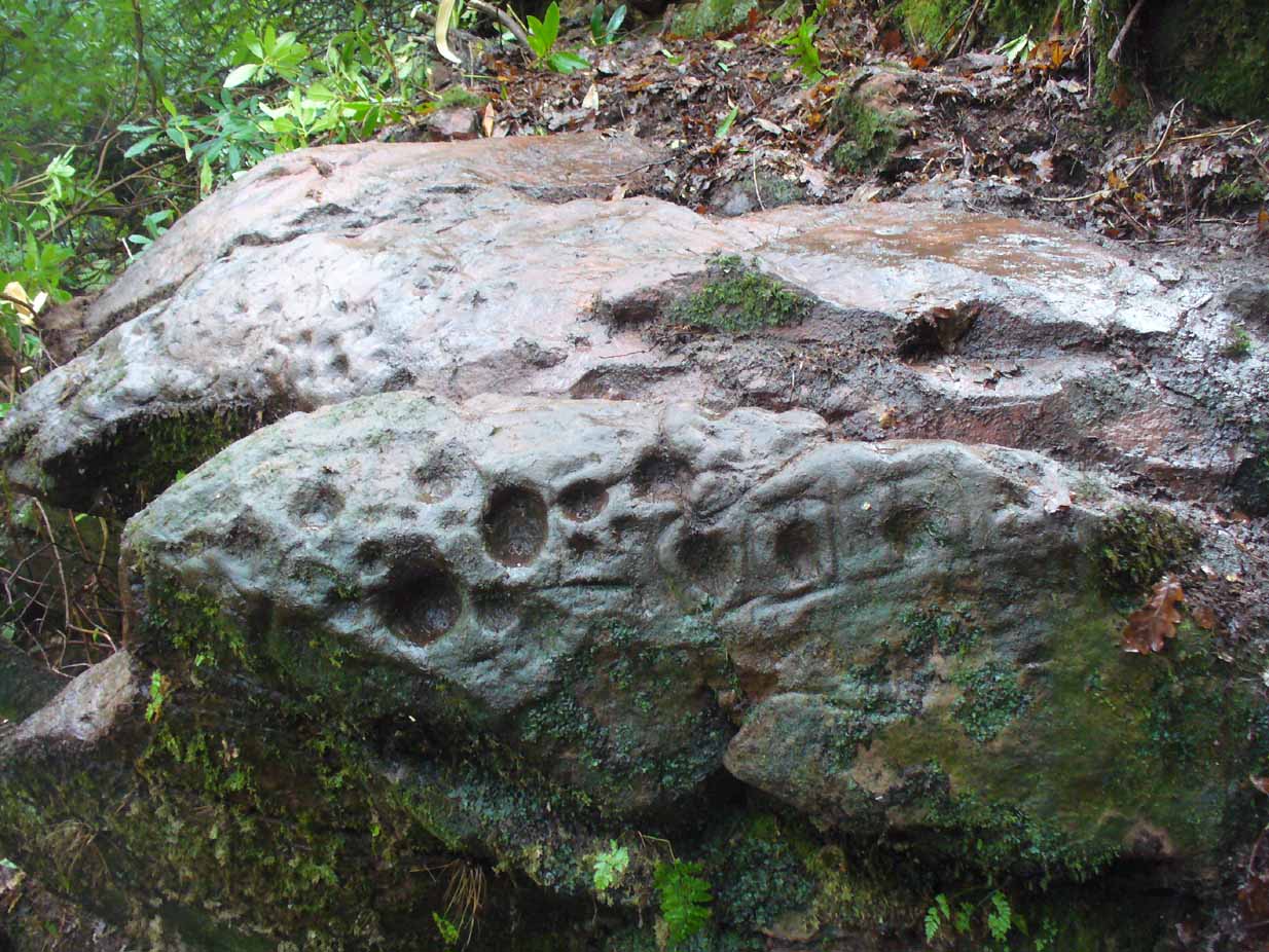
A very curious design here! Possibly carved at the same time as the Leckie broch to which it is attached—possibly not—we have here a curious amalgam of Nature’s incisions and human design, culminating in cup-and-rings and cups-and-squares no less! When we came to visit it a few days ago, Lisa Samsonowicz found the stone hiding away, buried beneath a thin layer of natural cover. The rest of the team thereafter enabled a much clearer pictures of the carving.
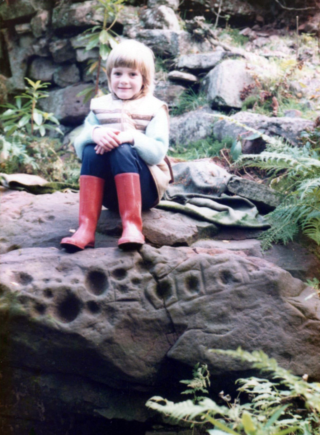
Star motif & other cupsYoung Allison on the new find (photo courtesy John McLaren)
We’re not quite sure who first rediscovered the carving. In an early photo of the site taken in the late ’70s or early ’80s, a young Allison McLaren sits highlighting the design. But she wasn’t the fortunate lass who discovered it! One account describes a local woman, Lady Younger of Leckie House, who was out walking her dog, accidentally dislodging some of the rocky debris of the Iron Age broch and unearthing the petroglyphs, thereafter taking Allison along to see it. The other account tells of it being noticed for the first time during an excavation of the broch by Euan MacKie and his team. Whichever it was, Prof Mackie (1970) was certainly the first person to write about it. He told:
“Part of the sandstone face of the northern end of the promontory on which stands the Leckie dun is covered with well preserved cup-marks, presumably much older than the dun. They were discovered when rubble and soil fallen from the dun was removed. Some of the cup-marks stand alone and some are surrounded by what appear to be incised rectangles in a ladder pattern. There are other, less clear markings.”
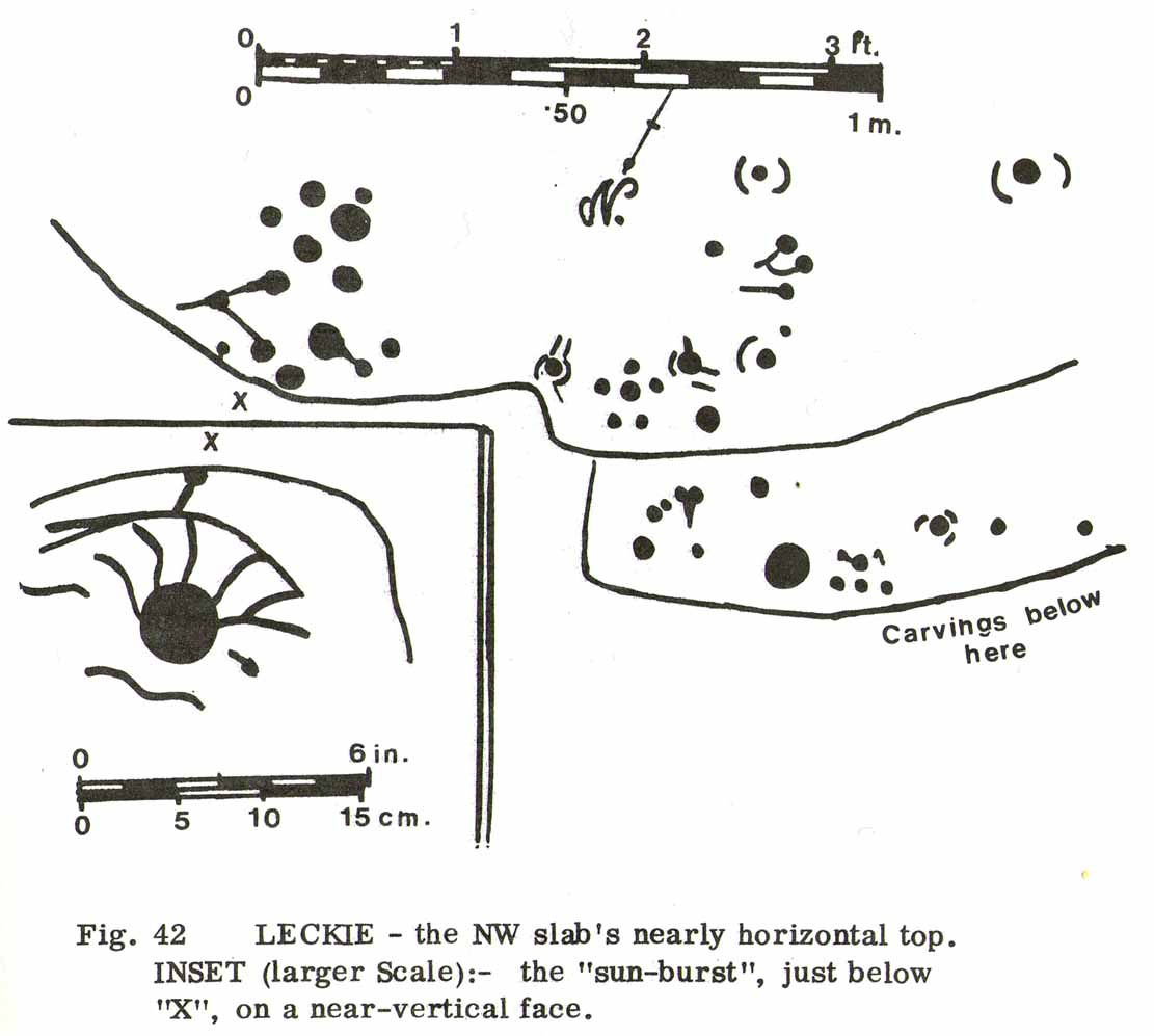
Ron Morris’ 1981 sketchSmall & large cupmarks
There then followed a series of written accounts, small and large, about the Leckie broch—but little else was said of the carvings. It wasn’t until Ronald Morris (1981) came to see them a few years later that they gained a slightly lengthier description. He described how the petroglyph was,
“carved over about 3m (yds) at heights of 1-2m (yds) on faces now sloping mostly 0-90º NW, with 3 cups-and-one-near-hexagonal-ring up to 12cm (4½in) diameter, a ‘sun-burst’ and other grooves, and at least 40 cups up to 12cm (4½in) diameter and up to 8cm (3in) deep. On a vertical E-facing slab there are also many grooves, some of which connect lines of cups. Some grooves resemble a ‘sea-horse’, an ‘axe’, etc. All except the cups are probably incised, but some may be natural.”
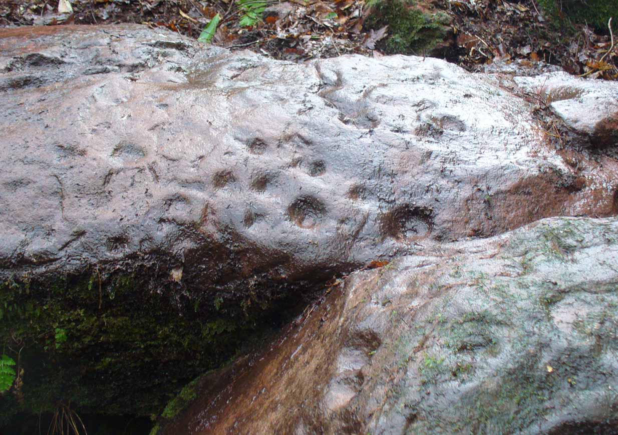
Large cupmarks on sloping faceLooking down the spine of 2 rocks
The entire design in fact covers two separate sections of rock. On the vertical face of one stone is a curious conjoined cup-and-rectangle, attached to a cup-and-square, attached to a traditional cup-and-ring. A cluster of other cups, large and small, are immediately left of this odd geometric pattern. The ‘cups’ within this section of the petroglyph are quite deep and, it would seem, were geological in nature but have been touched-up by human hands. Immediately below this rectangle-square-circle sequence, faint carved lines run a little further down the face of the rock. They were difficult to see clearly and require subsequent visits to enable a more complete picture. Along the top of this section of rock are several cups, one or two of them seeming to have faint rings around them. (at the very bottom of this vertical carved face, at ground level, a small section of man-made walling is visible, which was no doubt a section of the huge broch)
Above the top of this vertical carved face is a gap between this and a second, larger earthfast stone. This has a series of cups, some with faint rings around them, but most of them are just cups, both shallow and deep, running down the slope of the rock. A notable ‘star’ of five cups surrounding a single-cup stands out on this section. Some of them seem to have been geophysical in nature, but again have been touched-up and added to.
Cluster of curious peck-marks
Slightly higher still, on another third section of rock, a curious cluster of weird ‘pecks’, almost in a square pattern, with a possible cup-mark close to the edge of the stone is clearly visible. The edge of this rock seems to have been quarried and the markings here may just be mason marks preceding the breaking of the stone in the Iron Age.
Walk around to the south-side of the broch and there, in the walling, on a vertical stone face, is the small cup-marked Leckie 1 carving.
One final note of concern: the carving (and the broch) have become overrun with rhododendrons, to the point where they are severely damaging the monuments here. They need to be curtailed before further archaeological destruction occurs. Help!
Acknowledgements: Immense thanks to Lisa Samsonowicz, Fraser Harrick, Nina Harris, Frank Mercer and Paul Hornby for all their work, enabling a clear picture of the site. And a huge thanks to John McLaren of the Gargunnock Village History site for allowing us to include the early photo of the carving here – thanks John! 🙂
Take the B822 Fintry to Kippen road and just over 2 miles (3.3km) north of Kippen, take the small country lane on your left. Parking is truly troublesome along here, so: nearly half-a-mile along, a road/track on your right takes you into the huge forestry plantation (or ‘tree farm’ as Nina Harris calls them). Go up here and, when you reach the tree-line, walk along the outer perimeter fence to your left. Keep walking – and walking – through bog and over fence – keeping all along to the outside of the forest for more than a mile. You eventually reach a rise on the Balfron side with huge views to the west – and just here is an opening into the trees on your right where a long ridge of rock is obvious. You’re here!
Archaeology & History
Main feature of the carving
Not far from the recently rediscovered Footsteps Stone (coming soon…), this large cup-and-ring carving was found by Paul Hornby on an antiquarian rock art venture in November 2016 on a journey to the petroglyphs upon Balgair Muir, between Balfron and Fintry. It was a damn good day indeed! We’d been up here the previous week, but then the grey daylight gave little away. Upon revisiting the place on a brighter day, after a short while Paul called us over to where he’d been rummaging and, beneath a mass of fallen tree foliage, the long raised rock gave up some of its ancient symbols once again.
Very faint partial cup&rings?Main feature, looking ENE (photo by Nina Harris)
Along the main face of the stone are a variety of geophysical undulations and small natural hollows—lots of them!—some of which give the impression of being primitive cup-markings, but they’re more the result of erosion. However, amidst these are several very possible cup-markings, and some photo-images show that at least one of them has portions of a distinct faint ring around it, possibly two of them. On the whole however, we’d need a geological specialist to tell us with certainty about the other doubtful ‘cups’ here (TNA neeeeds an in-house crazy geologist into petroglyphs and things!).
Balgair Muir Woods designMain feature, looking west
As the rock face slopes down on its northern edges, away from the many natural pits and nodules, Paul uncovered two large incomplete ‘rings’, each with short outer ‘lines’, distinctly carved. The ‘rings’ are somewhat larger than the average cup-and-ring motifs — but it also appears that at least one of the ‘rings’ may be lacking an internal cup-mark.
Large semi-carved ‘bowl’ (photo by Nina Harris)
On the same piece of rock, several feet to the east and almost covered by an adjacent tree, we also found a large half-natural half-carved ‘bowl’ more than 12 inches (30cm) across with a possible cup-marking near its centre. Whoever carved this section of the petroglyph has definitely utilised the natural features in the rock and, it seems, may never have finished the work.
We need more visits to this area to find what more lies beneath the fallen forest debris.
Acknowledgements: Massive thanks to Paul Hornby for uncovering this carving. Huge thanks also to Nina Harris for her help and some of the photos; and also to Ann Rankin and Mick for all their relative help too. Until next time…
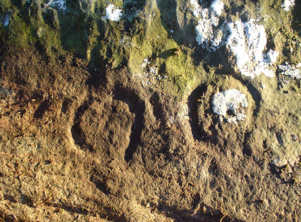
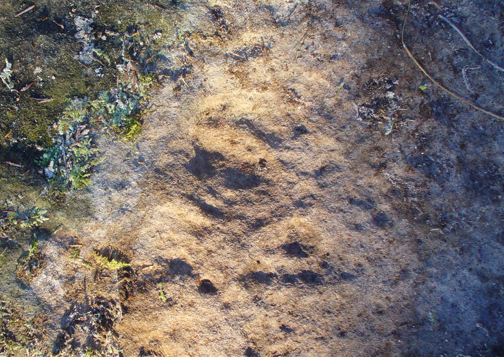
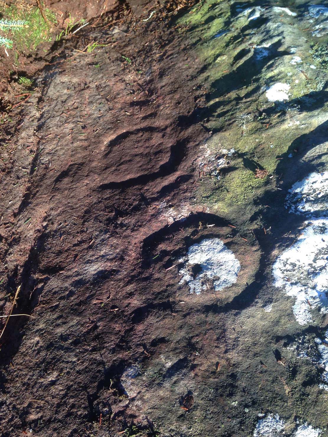
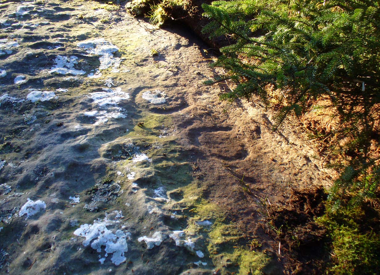
Take the directions as if you’re visiting the ornate petroglyphs known asthe Lunar Stone and the Spotted Stone. Walk past them and down the slope, NW, as if you’re heading to the small valley a few hundred yards away. As you reach the bottom of the slope, closer to the stream, a large boulder catches your attention. This carved stone is just a few yards before you reach it.
Archaeology & History
This simple cup-marked design below the northern slope of Stanbury Hill has, on its northeastern sloping face, a single cup-mark; then, past a curiously-etched line (probably more recent) is a larger circular feature, like a very shallow ‘bowl’ as in the one found in the superb Stag Cottage petroglyph complex 300 miles north (and several other carvings). A few yards away, a large single cup-mark has been etched onto another stone. As with quite a few carvings in this region, they have been missed in the standard archaeocentric surveys.
Take the same directions to locate the cup-and-ring stone of Ballochraggan 12. There are several rocks adjacent. The one immediately next to it, to the northeast, is the one you’re looking for. Be gentle and careful if you’re gonna look at it — deadly serious, be very careful indeed!
Archaeology & History
One of the most intriguing and most fascinating of all the prehistoric carvings I’ve yet to discover. Not that this was all my own work. If it hadn’t been for Paul Hornby, we might have simply walked past it as being little more than a single cup-marked stone—and in this area, single cup-marks tend to be little more than geological in nature.
After we’d looked over several of the registered carvings close by, I did my usual meandering back and forth, stroking stones and seeing if there were any carvings that had been missed by previous surveyors. And in walking past a small piece of smooth rock, a singular cupmark seemed to stand out. I walked past it, shouting across to my colleague.
“It looks like we’ve got a single cup-mark here Paul,” I said, “with possible half-ring.” Thankfully Mr Hornby gave it his better attention.
Mask Stone, with faint ‘urn’Close-up of features
The sun was still out and shining across the smooth rock surface, which tends to mean that you’re not seeing any carving on the stone quite as good as it actually is. Thankfully however, the sun was beginning to get lower and, when this happens, if we wet the rock, any carvings that might be there stand out much better. And this little fella just seemed to get better and more curious the more attention Paul gave it!
The first thing that became obvious were a series of faint carved lines above the single cup-mark. Initially these didn’t seem to merit much attention (straight lines on rock are usually more the product of geophysical action than that of humans), but as the rock got wetter, Paul saw something very distinct indeed.
“There’s a face on it!” he exclaimed. And indeed there was. A Rorschach response no doubt, but it was still very much like a face. This looked for all the world akin to the stylised olde English gentry sort of countenance, as in old cartoons. It was quite ‘distinct’, as such characters themselves insist on being! Yet around this initial face, more lines seemed to be emerging as the stone gave up more and more of its hidden story.
Standing back from an initial investigation, the carving was seen to consist of a triple-ring, but without the traditional ‘cup’ in its centre. Instead, the centre was marked simply by a small ‘dot’—perhaps, originally, being a small conglomerate hole formed as a result of another tiny harder fragment of stone falling away from its larger mass. But a ‘dot’ it was. The other carved ‘lines’ however, immediately below and attached to the triple-ring, gave us something almost unique—and another strong Rorschach response. As the photos clearly show, we have a distinct second ‘face’ made up of the same lines but in a quite different form. This ‘face’ has all the attributes we usually associate with pictures of mythical spirits, demons, or a mask—hence the name!
Paul took a series of fine photos, hoping that he could catch the image that our eyes could clearly see. And thankfully, his digital camera brought the image to life even better than our eyes did! The ‘mask’ is comprised of carved lozenge forms, akin to the more decorative ones we find at Kilmartin, and more especially around Newgrange, Ireland. We sat and talked about this: wondering and working out routes that we’d take over mountains and moors, from Ireland, to Kilmartin, then onto Ballochraggan, etching the same designs onto the rocks hereby and attaching similar mythic notions to them: of shamanism and kingship; underworlds and journeys—paradigms lost and certainly misunderstood in the non-polysemia of many modern academics.
Lozenges and rings
…The stone here was still slightly covered over and, beneath the loose grasses, another feature emerged of another petroglyphic rarity. At the topmost western side of the rock a straight line ran across the surface, seemingly marked by the hand of man, with a curious little line almost doubling back on itself for just an inch or so, and then feeling to run down the stone, towards the concentric rings and the face below. When we stood back and took the photos, this line and its tracer took on a form that I’ve only seen echoed in one of the Netherlargie tombs at Kilmartin, Argyll, 44.4 miles (73km) to the west. It is very distinct.
The beaker, rings & ‘face’
Spuriously ascribed as being ‘axe’ carvings (oh how archaeologists love this Rorschach projection), the Netherlargie North tomb cover-stone in Kilmartin has a series of burial ‘urns’ or beakers carved onto the rock, amidst a scattered collection of cup markings. (Beckensall 2005:73-4; Bradley 1983:92-3; Royal Commission 1971:68-70; Twohig 1972, etc) Here too at Ballochraggan we find another such symbol, but just a singular example, much larger and more clearly a beaker or urn, as are traditionally found within many old neolithic and Bronze Age tombs; although no tomb is immediately apparent at this Ballochraggan carving.
The entire carving is very faint indeed (you can’t even see it when you’re looking directly at it unless conditions are good) showing that it remained open to the elements for thousands of years. Other adjacent carvings lack the erosion that we find on this one, even on those which, as archaeologist Lisa Samson said, is “softer sandstone rock than this one”—implying that it’s one of the older carvings in this incredible cluster.
References:
Beckensall, Stan, The Prehistoric Rock Art of Kilmartin, Kilmartin Trust: Kilmartin 2005.
Bradley, Richard, Altering the Earth, Society of Antiquaries Scotland: Edinburgh 1993.
Royal Commission on the Ancient & Historical Monuments of Scotland, Argyll – volume 6: Mid-Argyll and Cowal, HMSO: Edinburgh 1971.
Twohig, Elizabeth Shee, The Megalithic Art of Western Europe, Clarendon: Oxford 1981.
Acknowledgments: Huge thanks again to Mr Paul Hornby for his considerable help with this site, and for use of his photos.
Access to these stones has, over recent years been pretty dreadful by all accounts. It’s easy enough to locate. Go into Calderstones Park and head for the large old vestibule or large greenhouse. If you’re fortunate enough to get one of the keepers, you may or may not get in. If anyone has clearer info on how to breach this situation and allow access as and when, please let us know.
Archaeology & History
Earliest known drawing from 1825, showing the carvings
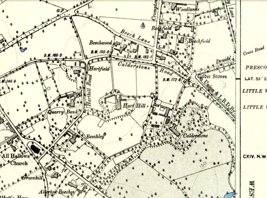
Marked on the 1846 Ordnance Survey map in a position by the road junctions at the meeting of township boundaries, where the aptly-named Calderstones Road and Druids Cross Road meet, several hundred yards north of its present site in Harthill Greenhouses in Calderstones Park, this is a completely fascinating site whose modern history is probably as much of a jigsaw puzzle as its previous 5000 years have been!
Thought to have originally have been a chambered tomb of some sort, akin to the usual fairy hill mound of earth, either surrounded by a ring of stones, or the stones were covered by earth. The earliest known literary reference to the Calderstones dates from 1568, where it is referenced in a boundary dispute, typical of the period when the land-grabbers were in full swing. The dispute was over a section of land between Allerton and Wavertree and in it the stones were called “the dojer, rojer or Caldwaye stones.” At that time it is known that the place was a roughly oval mound. But even then, we find that at least one of the stones had been taken away, in 1550.
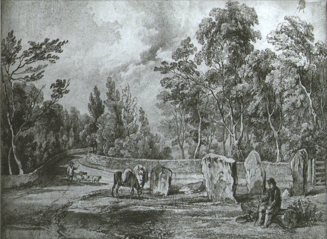
Little was written about the place from then until the early 19th century, when descriptions and drawings began emerging. The earliest image was by one Captain William Latham in 1825. On this (top-right) we have the first hint of carvings on some of the stones, particularly the upright one to the right showing some of the known cup-markings that still survive. By the year 1833 however, the ‘mound’ that either surrounded or covered the stones was destroyed. Victorian & Paul Morgan (2004) told us,
“The destruction first began in the late 18th or early 19th century when the mound was largely removed to provide sand for making mortar for a Mr Bragg’s House on Woolton Road. It was at this time that a ‘fine sepulchral urn rudely ornamented outside’ was found inside.”
The Calderstones in 1840
The same authors narrated the account of the mound’s final destruction, as remembered by a local man called John Peers—a gardener to some dood called Edward Cox—who was there when it met its final demise. Mr Cox later wrote a letter explaining what his gardener had told him and sent it to The Daily Post in 1896, which lamented,
“When the stones were dug down to, they seemed rather tumbled about in the mound. They looked as if they had been a little hut or cellar. Below the stones was found a large quantity of burnt bones, white and in small pieces. He thought there must have been a cartload or two. He helped to wheel them out and spread them on the field. He saw no metal of any sort nor any flint implements, nor any pottery, either whole or broken; nor did he hear of any. He was quite sure the bones were in large quantity, but he saw no urn with them. Possibly the quantity was enhanced by mixture with the soil. No one made such of old things of that sort in his time, nor cared to keep them up…”
But thankfully the upright stones remained—and on them were found a most curious plethora of neolithic carvings. After the covering cairn had been moved, the six remaining stones were set into a ring and, thankfully, looked after. These stones were later removed from their original spot and, after a bit of messing about, came to reside eventually in the curious greenhouse in Calderstones Park.
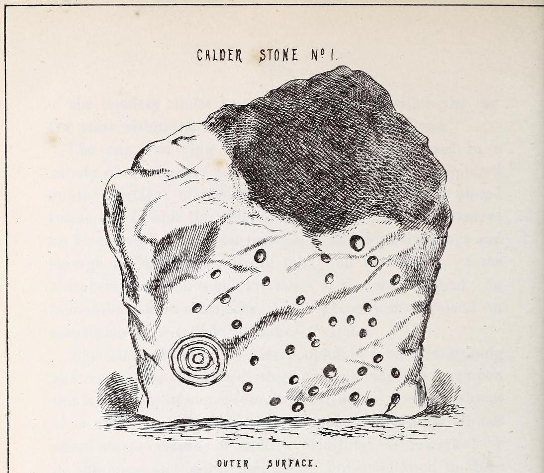
Simpson’s “Stone 1” outer faceSimpson’s “Stone 1” inner face
The carvings on the stones were first described in detail by the pioneering James Simpson. (1865) I hope you’ll forgive me citing his full description of them—on one of which he could find no carvings at the time, but he did state that his assessment may be incomplete as the light conditions weren’t too good. Some things never change! Sir James wrote:
“The Calder circle is about six yards in diameter. It consists of five stones which are still upright, and one that is fallen. The stones consist of slabs and blocks of red sandstone, all different in size and shape.
“The fallen stone is small, and shews nothing on its exposed side; but possibly, if turned over, some markings might be discovered on its other surface.
“Of the five standing stones, the largest of the set (No. I) is a sandstone slab, between five and six feet in height and in breadth. On its outer surface—or the surface turned to the exterior of the circle— there is a flaw above from disintegration and splintering of the stone; but the remaining portion of the surface presents between thirty and forty cup depressions, varying from two to three and a half inches in diameter; and at its lowest and left-hand corner is a concentric circle about a foot in diameter, consisting of four enlarging rings, but apparently without any central depression.
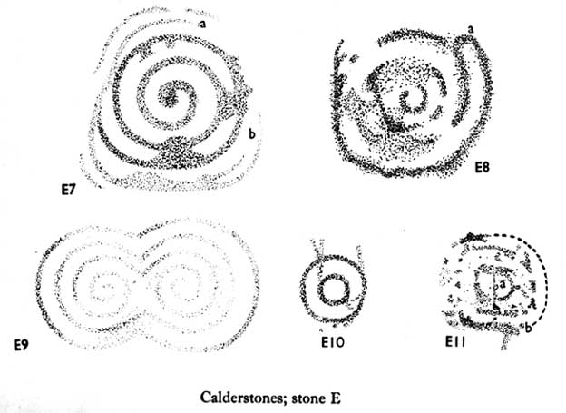
“The opposite surface of this stone, No. 1, or that directed to the interior of the circle, has near its centre a cup cut upon it, with the remains of one surrounding ring. On the right side of this single-ringed cup are the faded remains of a concentric circle of three rings. To the left of it there is another three-ringed circle, with a central depression, but the upper portions of the rings are broken off. Above it is a double-ringed cup, with this peculiarity, that the external ring is a volute leading from the central cup, and between the outer and inner ring is a fragmentary line of apparently another volute, making a double-ringed spiral which is common on some Irish stones, as on those of the great archaic mausoleum at New Grange, but extremely rare in Great Britain. At the very base of this stone, and towards the left, are two small volutes, one with a central depression or cup, the other seemingly without it. One of these small volutes consists of three turns, the other of two.
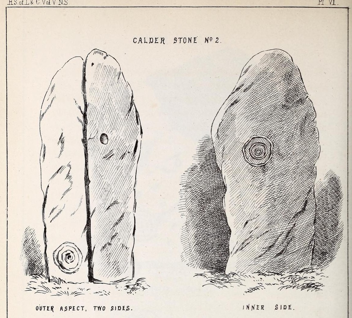
“The next stone, No. 2 in the series, is about six feet high and somewhat quadrangular. On one of its sides, half-way up, is a single cup cutting; on a second side, and near its base, a volute consisting of five rings or turns, and seven inches and a half in breadth ; and on a third side (that pointing to the interior of the circle), a concentric circle of three rings placed half-way or more up the stone.
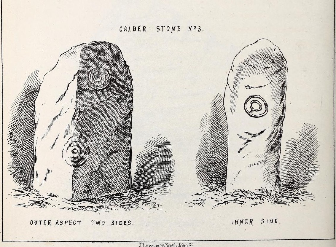
“The stone No. 3, placed next to it in the circle, is between three and four feet in height; thick and somewhat quadrangular, but with the angles much rounded off. On its outermost side is apparently a triple circle cut around a central cup; but more minute examination and fingering of the lines shews that this figure is produced by a spiral line or volute starting from the central cup, and does not consist of separate rings. The diameter of the outermost circle of the volute is nearly ten inches. Below this figure, and on the rounded edge between it and the next surface of the stone to the left, are the imperfect and faded remains of a larger quadruple circle. On one of the two remaining sides of this stone is a double concentric circle with a radial groove or gutter uniting them. This is the only instance of the radial groove which I observed on the Calder Stones, though such radial direct lines or ducts are extremely common elsewhere in the lapidary concentric circles.
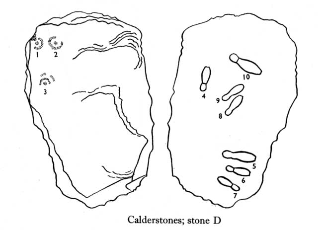
“The stone No. 4 is too much weathered and disintegrated on the sides to present any distinct sculpturings. On its flat top are nine or ten cups ; one large and deep (being nearly five inches in diameter). Seven or eight of these cups are irregularly tied or connected together by linear channels or cuttings…
“The fifth stone is too much disfigured by modern apocryphal cuttings and chisellings to deserve archaeological notice.
“The day on which I visited these stones was dark and wet. On a brighter and more favourable occasion perhaps some additional markings may be discovered.”
It wasn’t long, of course, before J. Romilly Allen (1888) visited the Calderstones and examined the carvings; but unusually he gave them only scant attention and added little new information. Apart from reporting that another of the monoliths had carvings on it, amidst a seven-page article the only real thing of relevance was that,
“Five of the Calderstones show traces, more or less distinct, of this kind of carving, the outer surface of the largest stone having about thirty-six cups upon it, and a set of four concentric rings near the bottom at one corner. One of the stones has several cups and grooves on its upper surface.”
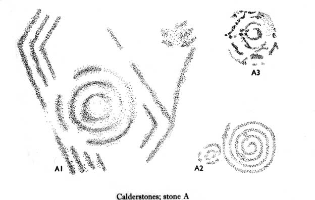
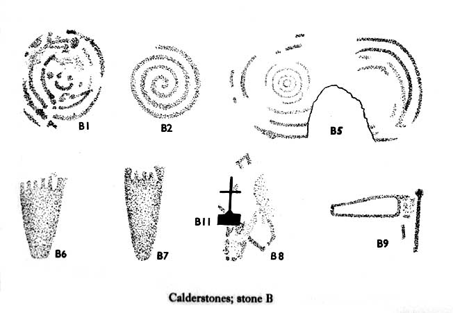
Carvings on Stone A (after Forde-Johnson)Carvings on Stone B (after Forde-Johnson)
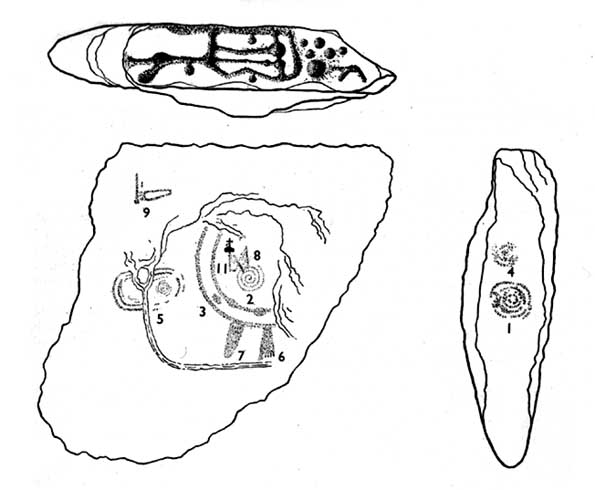
Unusual for him! The major survey of the Calderstone carvings took place in the 1950s when J.L. Forde-Johnson (1956; 1957) examined them in great detail. His findings were little short of incredible and, it has to be said, way ahead of his time (most archaeo’s of his period were simply lazy when it came to researching British petroglyphs). Not only were the early findings of Sir James Simpson confirmed, but some fascinating rare mythic symbols were uncovered that had only previously been located at Dunadd in Argyll, Cochno near Glasgow, and Priddy in Somerset: human feet – some with additional toes! Images of feet were found to be carved on Stones A, B and E. A carved element on Stone C may even represent a human figurine—rare things indeed in the British Isles!
Carvings on Stone DCarvings on Stone E
The detailed sketches here are all from Forde-Johnson’s 1957 article, where five of the six stones were found to bear petroglyphs (the sixth stone has, more recently, also been found to also possess faint carvings of a simple cup-mark and five radiating lines).
Elements on Stone C (after Forde-Johnson)More elements on Stone C (after Forde-Johnson)
The date of the site is obviously difficult to assess with accuracy; but I think it is safe to say that the earlier archaeological assumptions of the Calderstones being Bronze Age are probably wrong, and the site is more likely to have been constructed in the neolithic period. It’s similarity in structure and form to other chambered tombs—mentioned by a number of established students from Glyn Daniel (1950) to Frances Lynch—would indicate an earlier period. The fact that no metals of any form have ever been recovered or reported in any of the early accounts add to this neolithic origin probability.
There is still a lot more to be said about this place, but time and sleep are catching me at the mo, so pray forgive my brevity on this profile, until a later date…
Folklore
Curiously, for such an impressive site with a considerable corpus of literary references behind it, folklore accounts are scant. The best that Leslie Grinsell (1976) could find in his survey was from the earlier student C.R. Hand (1912), who simply said that,
“They were looked upon with awe by the people about as having some religious significance quite beyond their comprehension.”
There is however, additional Fortean lore that has been written about these stones and its locale by John Reppion (2011).
Ashbee, Paul, The Bronze Age Round Barrow in Britain, Phoenix House: London 1960.
Baines, Thomas, Lancashire and Cheshire, Past and Present – volume 2, William MacKenzie: London 1870.
Beckensall, Stan, British Prehistoric Rock Art, Tempus: Stroud 1999.
Beckensall, Stan, Circles in Stone: A British Prehistoric Mystery, Tempus: Stroud 2006.
Cowell, Ron, The Calderstones – A Prehistoric Tomb in Liverpool, Merseyside Archaeological Trust 1984.
Crawford, O.G.S., The Eye Goddess, Phoenix House: London 1957.
Daniel, Glyn E., The Prehistoric Chamber Tombs of England and Wales, Cambridge University Press 1950.
Faulkner, B.M., “An Analysis of Three 19th-century Pictures of the Calderstones,” in Merseyside Archaeological Journal, volume 13, 2010.
Forde-Johnson, J.L., “The Calderstones, Liverpool,” in Powell & Daniel, Barclodiad y Gawres: The excavation of a Megalithic Chambered Tomb in Anglesey, Liverpool University Press 1956.
Forde-Johnson, J.L., “Megalithic Art in the North West of Britain: The Calderstones, Liverpool,” in Proceedings of the Prehistoric Society, volume 23, 1957.
Grinsell, Leslie, Folklore of Prehistoric Sites in Britain, David & Charles: Newton Abbot 1976.
Hand, Charles R., The Story of the Calderstones, Hand & Co.: Liverpool 1912.
Herdman, W.A., “A Contribution to the History of the Calderstones, near Liverpool,” in Proceedings & Transactions of the Liverpool Biological Society, volume 11, 1896.
Morgan, Victoria & Paul, Prehistoric Cheshire, Landmark: Ashbourne 2004.
Nash, George & Stanford, Adam, “Recording Images Old and New on the Calderstones in Liverpool,” in Merseyside Archaeological Journal, volume 13, 2010.
Picton, James A., Memorials of Liverpool – 2 volumes, Longmans Gree: London 1875.
Simpson, James, Archaic Sculpturings of Cups, Circles, etc., Upon Stones and Rocks in Scotland, England and other Countries, Edmonston & Douglas: Edinburgh 1867.
Taylor, Isaac, Words and Places, MacMillam: London 1885.
Stewart-Brown, Ronald, A History of the Manor and Township of Allerton, Liverpool 1911.
Acknowledgements: With huge thanks to the staff at Calderstones Park; thanks also to the very helpful staff at Liverpool Central Library.
Along the A9 dual carriageway between Blackford and Auchterarder, take the A823 road south, up Glen Eagles as if you’re going towards Pool of Muckhart and Dunfermline. Less than 100 yards up the road, turn immediately to your right and park-up. On the overgrown grassy land on the right-hand side of the road, you’ll see this solid monolith calling for your attention. You can go through the gate. You can’t really miss it!
Archaeology & History
Looking south, to the fairy-haunted Ben Shee
Described by archaeologists as a Class 1 Pictish Symbol Stone (and shown on OS maps as such), this is a fine solid standing stone more than 5 feet tall, with a lovely view up Gleneagles to the fairy mountain of Ben Shee beckoning in the distance. Immediately north on the other side of the dual carriageway, the tree-lined mound 100 yards away is an ancient fort (which we’ll deal with in another entry); and of course we have the nearby companion of the Gleneagles A standing stone a coupla hundred yards west. Whether or not this stone and its western companion ever had anything to do with the lost stone circle of Gleneagles, we might never know.
Close-up of the carved designsCharles Calders drawing of the carvings
Although it seems consensus opinion that the standing stone here is prehistoric, the monolith was of some venerable importance to the Pictish people of the Ochils, who, according to the Royal Commission lads (1999) carved on this stone “the faint symbols of a goose and rectangle.” The rectangle, however, is in fact a parallelogram—as the images here clearly show. Archaeologist Richard Feachem (1977) thought the design was in fact “a double-sided comb.” I have my doubts (a much smaller and probably more recent parallelogram design was recently identified on the upright face of the large Dunruchan D standing stone, about 10 miles WNW of here). The ‘goose’ is carved above this geometric form and is much fainter, which may imply it was carved much earlier. In Elizabeth Sutherland’s (1997) survey, she suggests the bird may be an eagle. It is equally possible that it is a swan.
The earliest detaied account of this stone and its companion is in Mr Hutchison’s (1893) fine essay, where he wrote:
“On the south side of the road from Blackford to Auchterarder, about 150 yards west from Loaninghead where the line of the road is crossed by that from Gleneagles to Crieff, stands a fine stone of Highland grit. It measures 4ft. 10in. in height above ground, 10ft. in girth at the base, and 6ft. 9in. in circumference at top. It shows four sides of nearly equal measurement:— that facing north being 2ft 4in., south 2ft. 8in., west 2ft 5in., and east 3ft. On the north is an incised figure in the form of an parallelogram, 10in. broad by 9in. high, divided into three equal portions by two horizontal lines.”