Take the A6034 road between Addingham and Silsden and, at the very top of the hill between the two towns, at Cringles, take the small road of Cringles Lane north towards Draughton. Less than a mile on, veer to left and go along Bank Lane until you reach the track and footpath on your right that takes you to Moorock Hall. On the other side of the Hall, take the track on your left, along the wallside; and where the track turns left again, look into the field on the other side of the wall. You can see some of the ditch and embankment running across the field.
Archaeology & History
Found within the southwestern segment of the gigantic Counter Hill enclosure, near Woofa Bank, Eric Cowling (1946) described “an almost obliterated fortification” which has certainly seen better days — though you can make out the ditched earthwork pretty easily at ground level. When T.D. Whitaker visited this place sometime before 1812, he described it as a camp that “was found to contain numbers of rude (?!?) fireplaces constructed of stone and filled with ashes.” He also thought the enclosure was Roman in nature.
Western line of embankment
It’s a large site. Running around the outer edge of the embankment, this enclosure measures roughly 378 yards (345m) in circumference. It has diameters measuring, roughly east-west, 132 yards (121m); and north-south is 95 yards (87m). The ditch that defines the edges of the enclosure averages 6-7 yards across and is give or take a yard deep throughout — but this is not an accurate reflection of the real depth, as centuries of earth have collected and filled the ditch. An excavation is necessary to reveal the true depth of this. There also seems to have been additional features constructed inside the enclosure, but without an excavation we’ll never know what they are. Examples of cup-marked stones can be found nearby.
The Marchup Hill enclosure was described by the early antiquarian James Wardell (1869), who visited this and the other earthworks around Counter Hill. He told that this was,
“of oblong form, but broadest at the west end, and rather larger than the other. When the area of this camp was broken up, there were found some numbers of rude fireplaces constructed of stone and filled with ashes, and also a large perforated bead of jet.”
E.T. Cowling’s plan
Modern opinion places the construction of this enclosure within the Iron Age to Romano-British period, between 1000 BC to 300 AD. E.T. Cowling (1946) thought the Iron Age to be most likely, but it may indeed be earlier. His description of the site was as follows:
“At the foot of the southern slope of Counter Hill and close to the head waters of Marchup Beck is an almost obliterated fortification. These remains are roughly rectangular, but one side is bent to meet the other; the enclosure has rounded corners and has a ditch with the upcast at each side. The inner area is naturally above the level of the surrounding ground. In spite of heavy ploughing, the ditch on the western side still has a span of fifteen feet and a depth of five feet between the tops of the banks. Whitaker states that the camp “was found to contain numbers of rude fireplaces constructed of stone and filled with ashes.” These hearths appear to be the remains of cooking-holes such as are often found on Iron Age sites… Cup and ring markings are close at hand, but no flints have been found or trace of Mid-Bronze Age habitation. The enclosure is badly planned, the upcast on the western side would aid an attack rather than the defence.”
…to be continued…
References:
Cowling, Eric T., Rombald’s Way, William Walker: Otley 1946.
Wardell, James, Historical Notes of Ilkley, Rombald’s Moor, Baildon Common, and other Matters of the British and Roman Periods, Joseph Dodgson: Leeds 1869. (2nd edition 1881).
Whitaker, Thomas Dunham, The History and Antiquities of the Deanery of Craven in the County of York, (3rd edition) Joseph Dodgson: Leeds 1878.
Follow the same directions to get to the cup-marked stone on the slope behind Duncroisk Farm. Once here, look up the hillside and about 100 yards above you there’s the fence, and a gate in the fence. Go through that gate and walk uphill for some 20 yards where you’ll meet with a large sheet of flat sloping rock with a stream by its side. The crosses are on this rock sheet at the top left-hand side.
Archaeology & History
Although the stone here is pretty easy to find, the insignia carved on the rock itself can be troublesome to see. The accounts by both Cormack (1952) and Morris (1981) each recommend visiting the site around sunrise, but an hour before sunset is also profitable if you wanna see the design with any clarity. And of course, if you keep the rock-face wet (the adjacent stream is handy here) the carvings stand out even better!
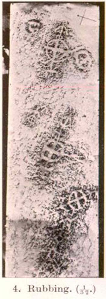
Main section of carvingSolar cross & arrow?
It’s a quite superb carving in a truly superb setting, come rain, shine or mist — but for the cup-and-ring aficionado’s amongst you this one might not get y’ going, as we’re looking at a carving that was probably born of the more recent mythic period. Although there are between two and four faded cup-markings here, the principal designs do not echo the more usual neolithic and Bronze Age carvings scattering this part of Perthshire. Instead we find very worn examples of what have been variously called “solar wheels”, “Greek crosses”, Celtic crosses, etc. We also find simple carved ‘arrows’ at the ends of both natural and man-made lines in the rock; along with very distinct ‘eye’ or vulva symbolism. (Crawford 1957) Added to this is the possibility of human figurines discernible in the carving, very similar indeed to those found in Spain (Kuhn 1956) and elsewhere.
The site was first described by E.A. Cormack (1952) who wrote the following, (slightly edited) piece:
“Examination of the rough and sloping rock surface revealed an interesting group of inscribed figures, confined to an area of about 8 by 2½ feet, four of which included a cross within a circle. The figures are difficult to discern, except when thrown into relief by early morning sunlight, but are clearly demonstrated on a rubbing.
Cormack’s 1952 rubbing of the carving
“The crosses may be described in three groups:
“Group 1 — a) Near the upper edge of the rock is a cross within a circle of 8-inch diameter. The vertical axis of the cross is extended below the circle for 4 inches, resting on an ill-defined rectangular base, and upwards for 5 inches to form an arrow-head with 3-inch barbs. At the junction of the shaft of the arrow with the top of the circle is a pair of contiguous rings of about 1-inch diameter. The cross is deeply cut, to about a half-inch depth, with equal arms 4 inches long and 1 inch broad. The left arm of the cross extends beyond the circle, but this may be due to the circle being slightly excentric in relation to the cross. The lower right quadrant of the circle is marred by a natural crevice in the rock, but careful examination shows that the circle does not cut the right arm of the cross.
b) On each side of this figure is a roughly circular marking, one about 4 inches above and to the left, of 3-inch diameter, and the other 2 inches to the right, of about 5-inch diameter. In each there is an indefinite depression across the centre.
“Group 2 — a) About a foot below and to the right of Group 1 there is a boldly cut cross within a 7-inch circle. Again the vertical arm of the cross is extended above and below the circle, downwards for 5 inches to a curved arrow-head with 4-inch barbs, and upwards as an equal armed 5-inch crosslet above which is a 4-inch circle with the central axis continued through it. (The junction of this axis through the circle with the top of the small cross is slightly angled.) The main cross and circle are cut to fully half an inch in depth and one inch in breadth, but the upper part of the figure is much less distinct.
b) About 8 inches to the left of the upper part of the above figure is a very faintly incised cross within a 2½-inch circle. It is difficult to discern on the rock, but can be seen in the photograph and is very clear on the rubbing. It also appears to have an arrow-head above it.
“Group 3 — a) A foot below and to the right of Group 2 is a clearly cut cross within a 6½-inch circle. A natural cleft in the rock has been used for one axis of the cross, which lies obliquely to the others already described, and this axis terminates in an arrow-head 3 inches below the circle, and another slightly smaller arrow-head is cut 2 inches above the circle; in each case the angle formed by the arrow being towards the circle.
b) Immediately below the last cross is a curious hieroglyph not easy to make out on the rubbing, but clear in the photograph. On an 18-inch vertical axis can be seen from above downwards an arrow-head, an oblique line to the left, a faint 2-inch circle, a transverse stroke, and finally two oblique lines to the right. A natural crevice to the left of the figure rather confuses the picture.”
Ron Morris’ (1981) description wasn’t as detailed and he was initially hesitant about using the site in his rock art survey of the area, as he thought it “most likely to be early christian” in nature and period. He changed his view after talking with an associate at Bergen University, who pointed out that the symbols found here up Glen Lochay were “exactly the same as Norway’s second commonest symbol, the ‘Cross-ring’, which is contemporary with their cup-and-ring series.” Morris described the carvings here as:
“3 ‘cross-rings’ and 7 other rings, some of which have traces of crosses within them. There are also grooves, some extending from a ‘cross’-line to form an ‘arrowhead’, and one group, with ring above, rather resembles a ‘man.’ Largest ring diameter, 20cm (8in) and greatest carving depth, 1cm (½in).”
Examples of the artistic symbolism found at this ‘Duncroisk Crosses Stone’ are scattered throughout western Europe from the Bronze Age period onwards: notably at Dowth and Clonfinloch in Ireland (Brennan 1983; Coffey 1912); Jonathan’s Cave, Fife (Simpson 1867); Valcamonica, Italy (Anati 1961); and all over Norway and Sweden (Coles 2005; Gelling & Davidson 1969; Janson 1966). In more recent times we find these curious symbols etched inside the prehistoric chamber of Ty Illtud (Grinsell 1981) — but these are thought to be later additions. However, the universal nature given to such interconnecting symbols such as those found here is, simply, ritual magick. We find it across the Himalayas, Africa, north and south America – just about everywhere. It would be quite wrong to believe that the presence of an encircled ‘cross’ on this stone relates it to a christian belief system, as such a motif is found in many non- and pre-christian societies with a mythic nature akin to that of the swastika, i.e., of a world unfolding or emerging from a centre-point and the arms of the ‘cross’ outwards defining the directions and boundaries of any specified cosmology: be it landscape, heavens, spirit worlds, pregnant belly, etc.
Solar cross? Eye? Vulva?…or dancing human figure?
As Cormack (1952) described, the respective groups of carvings are integrally linked by an interconnecting line that joins the symbols in the respective groups to the other symbols. The fact that the connecting ‘lines’ are natural is meaningful in the relationship between humans and Nature; but moreover, the connecting line linking the symbols strongly implies sequential reasoning and magickal import. Indeed, these three distinct clusters (see Cormack’s rubbing) are functionally akin to magickal sigils, examples of which are found across the ancient and modern world. This is a notion that must be given serious consideration as a function in the carved stone of ‘Duncroisk 4’. Equally we can see in one section of the carving what may be a dancing human figurine, very much like rock carvings found elsewhere in Europe and beyond.
Both Erich Neumann (1973) and Alex Marshack (1972), for slightly different reasons, would also see the images carved here as early expressions of human development: either through i) the emergence of archetypal patterns and the interpretative interplay of the ego, or ii) the intellectual evolution of magickal appliance, whereby imagery and human action are recognized as meaningful in a wider natural sense. In the case of Duncroisk 4 it would more likely possess magickal import, as symbols were much more than ‘art’ and possessed meaning on several interconnecting levels, one of which being ritual function — an element that modern archaeology is slowly learning to incorporate into its analyses.
Dancing Siberian ShamanDancing shaman figure?
A more in-depth comparative essay is really needed to give a clearer exposition defining the nature of this carving… My personal view is that the carving represents, not some solar design, but one of Britain’s earliest artistic examples of human beings, in this case dancing and beating a drum or bodhran. It may indeed be the earliest pictorial example of a bodhran in the country. I’d say so. There is also the distinct possibility that the dancing figure is a shaman. We have many petroglyphs from all over the world that highlight such a character, integral to all early cultures—and this is as likely a contender as any for such a figure. (see Gough 1999; Whitley 2000, etc) It may however, be a warrior with a shield. You see the problems we can have with these damn carvings! 🙂
Folklore
This carved rock is said by local people to have been where a ‘Celtic’ saint delivered sermons to the heathen populace. The saint concerned is likely to be the one who tradition tells gave his name to the small glen immediately across the track from here: St. Charmaig. Halfway up the small glen is a small cave, barely accessible, with untouched remains of dried roots and other elements of human habitation therein. A few hundred yards to the north in old Finn’s Glen, is the forgotten Waterfall of the Oracle which sometimes isn’t even there!
References:
Anati, Emmanuel, Camonica Valley, Alfred Knopf: New York 1961.
Brennan, Martin, The Stars and the Stones: Ancient Art and Astronomy in Ireland, Thames & Hudson: London 1983.
Coffey, George, New Grange and other Incised Tumuli in Ireland, Dolphin: Poole 1977.
Coles, John, Shadows of a Northern Past: Rock Carvings of Bohuslan and Ostfold, Oxbow: Oxford 2005.
Grinsell, Leslie V., “The Later History of Ty Illtud,” in Archaeologia Cambrensis, 131, 1981.
Janson, Sverker & Westman, David, Rock-Carvings at Fiskeby, Esselte AB: Stockholm 1966.
Kuhn, Herbert, The Rock Pictures of Europe, Sidgwick & Jackson: London 1956.
Marshack, Alexander, The Roots of Civilization: The Cognitive Beginnings of Man’s First Art, Symbol and Notation, Weidenfeld & Nicolson: London 1972.
Morris, Ronald W.B., The Prehistoric Rock Art of Southern Scotland, BAR 86: Oxford 1981.Neumann, Erich, The Origins and History of Consciousness, Bollingen Princeton University Press: New York 1973.
Royal Commission on the Ancient & Historical Monuments of Scotland, Archaeological Sites and Monuments of Stirling District, Central Region, Society of Antiquaries of Scotland 1979.
Simpson, James, Archaic Sculpturings of Cups, Circles, etc., Upon Stones and Rocks in Scotland, England and other Countries, Edmonston & Douglas: Edinburgh 1867.
Whitley, D.S., The Art of the Shaman: Rock Art of California, University of Utah Press 2000.
Either reach this from Dorchester’s Dyke Hills by crossing the bridge over the Thames at its southwestern side and walk thru the village and up the fields to the wooded rise on your left; or simply get take the road between Brightwell-cum-Sotwell to the delightful village of Little Wittenham and, on your right-hand side, notes the unmissable clump of trees and rise in the fields on your right. That’s the place!
Archaeology & History
Major Allen’s 1932 photo
To be found on the southern side of the River Thames, across from the huge Dyke Hills camp, this prominent enclosed hillfort was thought to be a place where the tribal peoples of differing groups converged — the Dubonni, the Catuvellauni, and Atrebates peoples. And to this day it remains impressive. Long thought to have been merely the province of Iron Age settlers, in more recent years it has shown to have had a longer and richer history than academics previously dare write about. In Jean Cook’s (1985) fine work on the archaeology of the region, she described the typical narrative Castle Hill elicited from professionals until only a few years back, saying:
“The hillfort on Wittenham Clumps covers approximately 4 hectares (c. 10 acres) and comprises a single ditch and rampart. It commands superb views northwards up the Thames valley and to the south and west across the Vale of White Horse to the Berkshire Downs, where a series of similar hillforts follows the line of an ancient route — the Ridgeway. The fort has never been excavated, although frequent past ploughings have produced Iron Age and early Saxon sherds as well as Romano-British pottery. However, to the south of the hillfort…a well-stratified Iron Age settlement was found. It seems probable on the basis of other excavated sites that the fort was permanently occupied. It would have developed as a regional administrative and political centre, with specialist craftsmen and traders and would have performed some of the same functions as a medieval market town.”
Although Cook’s latter remarks should be addressed with caution (market economics was far from the mythic perspectives of Iron Age people), this great site was of obvious importance. But later excavations at the site in 2002-03 showed that the site had in fact been used by neolithic people and, around the tops, flints and other remains were found that took human activity here back into mesolithic times, with some finds dated around 6000 BC! More surprisingly (to archaeologists anyway) was that Castle Hill continued to be used way into medieval times!
Thankfully much of this place is still pretty well-preserved and is well worth exploring to historians, pagans and walkers.
References:
Cook, Jean, “Before the Roman Conquest,” in Dorchester through the Ages, Oxford University 1985.
Cook, Jean & Rowley, Trevor (eds.), Dorchester through the Ages, Oxford University 1985.
Easy to find. From Dorchester town centre, take the road at the bottom of town where the church is and walk along to the end where a footpath takes you into the field. Once here you’ll note a rise in the land at the end, stretching away to the west and the River Thames. That’s your Dyke Hills!
Archaeology & History
Plan of Dyke Hills (after Cook, 1985)
This site is another example of the considerable neglect shown to the prehistoric archaeological remains in and around the Dorchester region, despite Jean Cook (1985) describing the place as “a site of major local, regional and national importance.” Which is a pity, as the site here was once huge and it seems that much could have been learned from here. (you’ve gotta ask: do those doods who allegedly work for English Heritage care more for the ancient sites, or the money their organization gets?)
Lane-Fox’s 1870 survey
It would seem that the majority of the site was Iron Age in nature, with snifflings of Bronze Age remains scattered here and there. The primary position of the massive dykes and construction of internal domestic structures immediately below (south) of the dykes, was hemmed in on all sides by the surrounding River Thames and one of its tributaries, giving the place an excellent position in terms of food, plus shelter and protection from any intrusive tribes or hungry winter animals.
The first excavation at the huge dykes that define the northern edge of this ‘monument’ was done in 1870 by the renowned General Pitt-Rivers, then later Colonel Lane-Fox (at the time the Secretary of London’s Ethnological Society), as they were very concerned about the damage that was being inflicted upon the site, when the local landowner allowed sections of the banking to be “reduced for cultivation.” An article in the Saturday Review magazine on July 2, 1870, told of these concerns and what was written — as Jean Cook so rightly tells — “has a depressingly modern ring to it”:
“…the fortress at Dorchester and the fortress on Sinodun (Castle Hill) are among the most speaking monuments of the earliest history of our island, and till lately they were among its most perfect monuments. But it is a grievous truth that while we are writing, the dykes at Dorchester are being levelled. Hitherto the neighbourhood ground has been grazed and the harmless sheep is no foe to history; but it has lately occurred to the owner of the ground hat a few shillings more of yearly profit might be gained by turning pasture land into arable; and to such a sordid motive as this these precious antiquities are at this very moment being sacrificed. At least a third of the dyke has already been lowered, and will gradually be utterly destroyed beneath the yearly passage of ruin’s merciless plough share. Such wanton destruction naturally aroused the indignation of men of taste and knowledge, especially in the neighbouring University. A vigourous appeal to the owner to stay his hand was made by some of the most eminent Oxford residents, and an attempt was made to call public attention to the subject by describing the state of the case in various newspapers…”
Lane-Fox’s 1872 photo
But the digging into the dykes continued. For some time at least — until Colonel Lane-Fox himself went to the see the landowner and “persuaded” him to stop what he was doing. A method we should always keep in mind ourselves…
The modern state of the Dyke Hills is summarised once again in Jean Cook’s (1985) fine survey of the region, where she wrote:
“This great enclosure, known to archaeologists as an oppidum, covered 46 hectares (c. 114 acres) and as defended by a massive double bank and ditch to the north and to the east. The southern and western boundaries have all but disappeared, but can be traced in lines of modern field boundaries beyond which the Thames forms a natural boundary. The interior is (now) empty, but cropmarks reveal that it is full of enclosures, pits and circular houses aligned along a regular pattern of internal roads. Although there has been no scientific excavation within Dyke Hills, ploughing of the site has produced one of the densest concentrations of Iron Age coins in Britain.”
It would appear that this site was of considerable importance for local tribes and would have been home to powerful chiefs and impressive-looking shamans! The large Castle Hill site immediately across the river would have had obvious links to this once-omportant prehistoric settlement.
References:
Cook, Jean, “Before the Roman Conquest,” in Dorchester through the Ages, Oxford University 1985.
Cook, Jean & Rowley, Trevor (eds.), Dorchester through the Ages, Oxford University 1985.
Williams, Geoffrey, The Iron Age Hillforts of England, Horace Books 1993.
An intriguing and little-known carved stone whose existence has been brought to our attention by historian and author John Dixon. Its precise history and nature seems unknown; but aspects of the carving possess symbols that are found on early christian remains, as well as some cup-and-ring designs. John wrote:
Artist’s impressionFoulscales Stone
“This enigmatic stone (27 inches height, 12 inches wide, 6 inch thickness), anciently known as the Yolstone and later as the Bonstone, once stood behind Foulscales Farm, near Gibbs. For some reason the stone was removed from this site and taken into the cellars of Knowlmere Manor under the authority of the Peel Estate.
The stone displays possible early native chi-rho symbols that may have a 6/7th century provenance. The lettering ‘HT’ look to be of 16/17th century origin and may refer to the Towneley family who held lands in Bowland.”
Was it a boundary stone? A gravestone? Was it an early christian stone? A Romano-British stone? The carved circles with ‘crosses’ inside them are typical Romano-British period designs, covered extensively in the early works of J. Romilly Allen and found to be widespread across Britain. Any further information on this stone would be greatly appreciated.
To be found on the wooded hill about 160 yards north of Wallstale Farm, on the Polmaise Road on the western side of the M9, a mile or so south of Cambusbarron, below the hugely impressive Murrayshall Quarries. Walk up the steep slope into the woodland and when you reach the level you’ll find the stonework remains. It’s on the edge of the slope in the trees.
Archaeology & History
This old fortified walled structure is best seen in the winter months when all the vegetation has fallen back to Earth. If you come here in the summer, the woods are nice but the monument can’t be seen as clearly. Found at the top of the slope above the roadside, it was described in the Stirlingshire Royal Commission (1963) account as follows:
Ground-plan of Wallstale Dun (after RCAHMS 1963)Wallstale Dun, up there somewhere!
“It is almost circular in plan…measuring about 45ft in diameter within a ruined stone wall some 11ft in thickness. Except on the ESE side, where the entrance was probably situated, the wall can be traced continuously by patches of rubble core, and round the east half outer facing-stones are visible up to a maximum height of four courses. In contrast, the inner face is only exposed for a short distance on the ENE. The interior of the dun is featureless. On the NW side the dun is protected by a rock-cut ditch of substantial proportions which traverses the spur; it measures 26ft in width at the top and the scarp is 5ft 6in in depth.”
References:
Royal Commission on the Ancient & Historical Monuments Scotland, Stirling – volume 1, HMSO: Edinburgh 1963.
Follow the same directions to get to Bordley’s Druid’s Altar circle. Where the little rough car-parky-bit happens to be by the cattle-grid, look up the sloping field where the wall runs up in a line and follow it up on foot. A coupla hundred yards up you’ll see a small craggy outcrop in front of you and another line of drystone walling in the corner. Just below this craggy outcrop you’ll notice a raised embankment comprising a line of small rocks running along the edge of the hill. This is the first bitta prehistoric walling that makes up a part of the settlement system. From hereon, follow y’ nose along and up the hill and look around. The settlement’s all around here!
Archaeology & History
This is quite an extensive area of prehistoric (seemingly Iron Age) enclosures on the top and around the edges of the unnamed rocky peak at the top of the large open Lantern Holes field. I’m not aware of any excavation work that may have taken place at this site, so please excuse me of any errors in the description that follows. (if anyone’s got an excavation report of the site, I’d love to read it!)
As with the many other settlements and enclosures in this region, much of it comprises of extensive stonework built up into and against the geological limestone bedrock either side of this hilltop site. Huge lines of prehistoric walling, measuring anything between one and three yards across, runs for hundreds of yards in and around this set of enclosures. We also find several distinct and well-preserved examples of old hut circles (one of which appears to have been re-used as a sheep shelter in more recent centuries) dotted around the edges and in the middle of larger sections of enclosed stone walls. This is all very impressive when you consider it was done a coupla thousand years back!
Walled enclosure on south sideWalling along SW edges
Very similar in design to the prehistoric settlement enclosures on the other (south) side of the valley at Hammond Close Pasture, above the Druid’s Altar, though more extensive. Measuring roughly 340 yards (311m) along its longer southeast-northwest axis, and nearly 280 yards (254m) from east-to-west, the uppermost parts of the site have at least seven separate large elliptical ‘enclosures’ built within the rocky enclaves, made up of typical Iron Age wall systems: a series of large upright monoliths packed up by smaller packing stones all along the length of the walling (using a system that still prevails today in drystone walling techniques on our upland moors). A couple of the photos here illustrated the walling very well and give you an idea of what to look out for if you’re out wandering the region, looking for old sites.
Although the walling we see today is barren and easy to spot, remember that in the time when people built these great structures, you wouldn’t have been able to see them, as they’d have been deliberately covered over and camouflaged with dressed earth and plants. In watching people emerging from these enclosures, you’d have got the distinct impression that they literally came out of the hill itself: a motif well-known to folklorists in relation to the origin of faerie-folk and other ‘little people.’
We need to go back up here and explore this settlement a bit more, as there’s tons more to be seen. And if anyone knows of any surveys that have already been done of this site, it’d be good to read the reports, preliminary or otherwise. A rough-camping weekend is planned on the tops at the break of Spring – so contact us if you’re into joining us for the amble. I reckon there’s gonna be other sites hidden in the landscape up here that even Arthur Raistrick missed out on!
…to be continued…
References:
Raistrick, Arthur & Holmes, Paul F., Archaeology of Malham Moor, Headley Bros: London 1961.
From Malham village, take the winding uphill road up Malham Rakes (not the Malham Cove road). If you aint sure, ask a local. Get to the top of the long winding road and, a mile on, you meet with another single-track road on the top level known as Street Gate. Stop here, then head across the grasslands on the left-side of the road, southwest. There are a couple of footpaths running over the land here: I wouldn’t say it makes much difference which one you take as they take you in the right direction. You’ll eventually meet the old craggy hilltop with the drystone walling down t’other side of it. You’re here!
Archaeology & History
The history of this region seems to have been covered to a great deal by the likes of Arthur Raistrick and his mates, though I can’t find a specific entry in mi library about the remains we’re looking at here. Surrounding the edges of the small hill, as can be seen in the aerial photo here, walling has clearly been built up around it, with considerable remains still visible at ground level, as indicated in the photos aswell.
Eastern edges of enclosureEastern walls, looking north
A settlement or large stone-walled enclosure, lying primarily on the north side of the drystone wall, measures approximately 82 yards north-to-south, and roughly 78 yards (72m) east-to-west, with a rough circumference around the outer edges of its rough elliptical outlines of more than 270 yards (250m). Along the walled edges can clearly be seen several ‘hut circle’ remains: one in particular at the northeastern side and, more prominently, at the southeastern side, are in reasonably good states of preservation. The northeasterly hut circle measures approximately six yards across. The stone walls of this circle are more than a yard wide. The ‘hut circle’ on the southeastern corner are more prominent and is in a better state of preservation, but much of the structure has of course been ruined to build the adjacent, more modern, drystone walls. This circular structure is larger than its counterpart on the northeast, measuring some 13 yards across.
The southern edge of the main settlement walling has been built up against and onto a large length of bedrock running roughly east-to-west. This inclusion of local geological features within man-made settlements and houses is a feature found all over Malham Moor and adjacent areas, for many miles around here. (see the Hammond Close settlement, for example) The southernmost section of the Torlery Edge settlement is in a reasonable state of preservation, as is the length of walling along its eastern edge. Along the northern section of the settlement it seems that an internal enclosure feature has been built (“perhaps for cattle?” would be the archaeologists usual query); whilst the western edges are the least visible part of this monument.
Hut circle on southern edgesHut circle, looking north
If we now jump over the drystone wall running along the southern edges (and visible in the aerial photo above), we can see a series of six, perhaps seven, hut circles, all adjoining each other and running along the line of the wall. Some of these are in a very good state of preservation and an excavation of these sites might prove fruitful. (unless it’s already been done – does anyone know?) Two of these hut circles have entrances clearly visible. They are all roughly the same size and structure, with average diameters (from outer wall to outer wall) of 7 yards. They consist of a rough ring of small upright stones, packed with smaller rocks and (in bygone times) peat and wood. Sheltered from the north winds by the ridge above it and the extensive ancient enclosure walling (not the drystone, which in itself is very old), this row of prehistoric buildings were probably for members of the same tribal group.
Without excavation it’s difficult to date these hut circles, but they would probably have been used between the Bronze Age and Romano-British period. There is every likelihood they were also used up to the medieval period, as this land was acquired (i.e. stolen) from local people by the Church and their law-bringers. We know that much of the landscape hereabouts was possessed by Fountains Abbey in the 12th century, who made extensive use of the area for their cattle; and we find considerable evidence scattering these hills of medieval archaeological remains.
Although the site is catalogued as a separate site from, say, the settlement remains and enclosures we find at Combe Hill, Prior Rakes, New Close, and other field areas close by, this individual archaeological site must be assessed as part of a greater collective series of settlement remains hereby. Instead of looking at this as an individual settlement, its relationship with the others in the vicinity needs re-evaluating and contextualizing and set within a wider and more realistic vision. Whilst appreciating that detailed modern excavations have yet to be done in this region on a scale that is required (as with many of our northern archaeological landscapes), it is probable that this singular settlement was part and parcel of what was once a prehistoric city.
If you visit this particular site, spend a few days looking round at the many other settlements and prehistoric religious sites in the area. And don’t forget to look and enquire as to why the Romans came and built a huge monument near the centre-edges of this domain of our prehistoric ancestors. Tis a fascinating arena indeed…
References:
Dixon, John & Phillip, Journeys through Brigantia – volume 2: Walks in Ribblesdale, Malhamdale and Central Wharfedale, Aussteiger: Barnoldswick 1990.
Raistrick, Arthur & Holmes, Paul F., Archaeology of Malham Moor, Headley Bros: London 1961.
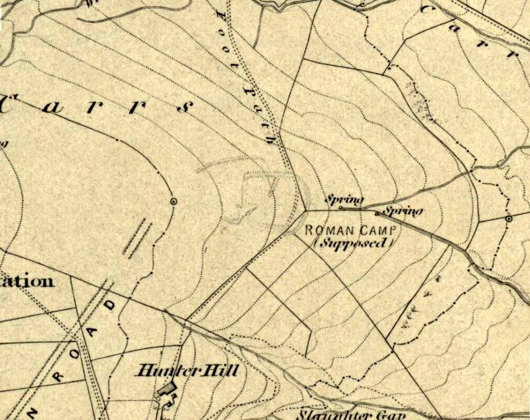
Troublesome to get to if you don’t know the area. You can get here rom Halifax, up through Highroad Well towards Wainstalls, keeping to the road that leads to the Oxenhope windmills. A short distance before the windmills, as the road levels out, keep your eye out on the right where the valley drops down (east) to the Halifax golf-course. If you’re coming from Oxenhope, walk up past the windmills at Nab End until the road starts going back downhill. As you look down and walk past the valley with the golf course in it, a footpath is on your left running diagonally over a field. Cross the stile and walk alongside the wall for about 200 yards until you reach a gate on your left. Go through this and walk along until you see the ditched earthworks that make up this little-known monument…
Archaeology & History
Not to be confused with the large circular enclosure that once crowned the nearby Hunter Hill, the nature and age of this large D-shaped earthwork has long been a source of speculation, with the majority of it centring around a Roman origin — and for good reason, it has to be said!
NW section of earthworksSouthern section of ditch
More than 280 yards (260m) in circumference, its north-south axis measures 82 yards (75m) at the greatest and 88 yards (81m) east-west. Its main feature is a decent ditch that averages 8-10 feet across round most of the D-shaped feature, and between 2-3 feet deep. It would obviously have been deeper than this when the ditches were first dug, but it’s now very overgrown across the entire site with Juncus grasses and tribbles (tussocks). A small internal ditch runs into the enclosure from the northern side. Its function is unknown. A small mound near the centre of the site has been posited by Calderdale archaeologists to be modern remains.
Carrs enclosure on 1852 map
Although the main feature is the D-shaped earthwork, other features are apparent. For example, what looks like another man-made dyke cutting into the site on the southwestern side is in fact a natural stream channel. This natural feature may have been an integral part of the enclosure when it was first built. Above the northwestern edge of the ditch (as can be seen on the aerial photo) are other earthworks that run around the western edge of the main feature. This is probably what F.A. Leyland (1867) meant when he described there to be “the remains of several lines of intrenchments” here. Also coming into the southwestern side are what are thought to be the remains of a Roman Road. Early OS-maps (above) show the road running within yards of this enclosure — and it was this which, logically, led many earlier researchers to posit the notion that this site was in fact Roman. However, a dig here in 1951 recovered prehistoric pottery, which knocked the date back to the Iron Age.
Northern line of ditch
On the south and east sides, parts of the ditch and embankment have been removed by quarrying and farm-workings, with the walling on the eastern side completely ruining that part of the monument. A great number of flints have been found on the hills above here. I’m unable to give a more detailed exposition on the archaeological finds at this site as I don’t have a copy of Mr Varley’s (1997) essay that he wrote for the Transactions of the Hunter Archaeological Society, which apparently gives more info. When I manage to get a copy of the journal/essay, I’ll add the relevant data to this profile.
A note must also be made of another, previously unrecognized enclosure on the same hilltop a couple of hundred yards to the west from here. Very little trace of it is still visible at ground level, but the outline of the curvaceous quadrilateral ditch form can be seen from the air. It would appear from its form to be consistent with an Iron Age enclosure, though without further research this has to be proclaimed as hypothetical. No excavations are planned here in the near future.
Folklore
In F.A. Leyland’s (1867) superb commentary to Mr Watson’s History of Halifax, he told us:
“There is a well-preserved tradition amongst the inhabitants that a battle in which numbers fell was fought at a place called the Slaughters or Slaughter Gap, in the hollow between the Carrs and Hunter-hill. Fragments of gun-barrels and locks, with human bones, have been found about the place…”
But Leyland deemed the armoury finds here — that appeared to substantiate the folklore — were from a much later period in history than the enclosure. But I must draw attention to the remarkable Mixenden Finds, as they’ve become known: a collection of finely polished prehistoric axes and other stone remains a few hundred yards below The Carrs and which may relate to such folklore.
References:
Leyland, F.A., The History and Antiquities of the Parish of Halifax, by the Reverend John Watson, M.A., R.Leyland: Halifax n.d. (c.1867)
Varley, Raymond, “The Excavation of Castle Stead at Manywells Height, near Cullingworth, West Yorkshire,” in Transactions of the Hunter Archaeological Society, volume 19, 1997.
Varley, Raymond A., “Lost Neolithic and Bronze Age Finds from Mixenden, near Halifax, West Yorkshire,” in Yorkshire Archaeological Journal 70, 1998.
Easy enough to locate. In Grassington go up the main street a coupla hundred yards, turning left up past the small church, taking the footpath on your right heading up to the fields that stretch to the north. Don’t mistake the remains of the medieval village that you’ll pass for the Iron Age and Romano-British site that we’re heading for, another coupla hundred yards up. You’ll notice a lot of old low walling structures on the slopes heading up above you. That’s the stuff!
Archaeology & History
Despite the industrial devastation of the landscape on the hills around here, this entire area still teems with prehistoric archaeological remains, making you wonder just how much more once existed in this region. In bygone days Prof Anne Ross thought this region to be the capital of northern England in Iron Age days. She could be right: in just about every nook and cranny of small valleys and rivulets we find evidence of ancient people everywhere for miles around, settlement upon settlement in every direction you take. The remains found here at High Close Pasture typifying the examples any ardent antiquarian will come across in this region of upper Wharfedale.
Druid’s Circle (Bogg 1904)Earliest known photo in 1899
The settlement remains and ancient cultivations at High Close have been described by various writers over the last hundred years, with Edmund Bogg (1902) calling the most notable of the remains here the ‘Druid’s Altar’ (not to be confused with the other Druid’s Altar at nearby Bordley); a title that was similarly described as “The Druid’s Circle” when Eliot Curwen surveyed the area. It is also locally known as ‘The Circus’, after it being a place where celebrated events once took place. This Druid’s Circle section is,
“an oval area 150 feet long by 75 feet wide. It consists of a bank surmounted by a single or double-row of flat-topped stones about one-and-half feet high by 2 feet wide… This may have been a communal meeting place of the Iron Age folk, who cultivated these fields, and who lived in isolated huts.” (Elgee & Elgee 1933)
The notion of the circle being a communal meeting place was echoed by Mr Curwen (1928) in his slightly more detailed description of this place. He told that the interior of the Druid’s Circle had been levelled:
“It lies eight feet below the surrounding banks to the northeast and east, to which it rises with a gradient of 8 in 21. The bank to the north is less high, while to the south and west the arena, while seperated from it by the bank, is above the level of the sloping hillside. The encircling bank is surmounted by a single (and) double row of stones for three-fourths of its extent. These are apparent to the east and south, but are less so to the west, as along this side a stone wall has been built actually along the bank of the Circus; the stones belonging to this bank are, however, quite clear below the footings of the wall. From northeast round by south to southwest the row of stones is double. Those in the inner row, forty-six in number, stand some eighteen inches high; they are about two feet wide and are flat-topped, the line is almost continuous, and in parts the stones are placed edge to edge. A second row of smaller stones backs the larger ones. Entrance is obtained to the central level area by a gap to the southwest. No fosse surrounds this earthwork. To the southeast, a lynchet four feet high runs off it, while to the north a low stoney bank runs off in a NW direction, and one of the larger stony banks approaches to within a few feet of the northwest.”
In the fields above, particularly on the east and north of this notable ruined stone ring, the extensive “cultivation pastures” as they’ve been called, are evident all over the place. Hut circles and copious other antiquities can all be found within a square mile of this spot. If you like your Iron Age archaeology, this area will knock yer socks off!
…to be continued…
References:
Bogg, Edmund, Higher Wharfeland, James Miles: Leeds 1904.
Charlesworth, Miss D., ‘Iron Age Settlements and Field Systems,’ in Archaeological Journal, volume 125, 1968.
Curwen, Eliot, ‘Ancient Cultivations at Grassington,’ in Antiquity, June 1928.
Elgee, Frank & Harriett, The Archaeology of Yorkshire, Methuen: London 1933.
Raistrick, Arthur & Chapman, S.E., ‘The Lynchet Groups of Upper Wharfedale, Yorkshire,’ in Antiquity, June 1929.
Speight, Harry, Upper Wharfedale, Elliott Stock: London 1900.


")


")
")
")