From Skipton head up the B6265 Grassington Road and after a short distance you will reach the Craven Heifer Pub on your left. About ¾-mile past the pub is a small turning on your left called Bog Lane. Go along here for about ¼-mile till you come to a sharp left bend and on the right you will see a gateway with room to park. Once here you’ll notice a sharp-pointed hill—and that’s Sharp Haw! Go through the gate, up the gravel track parallel to the wall on your left for 500 yards. Where the wall ends take the small path on your right and walk up here for ¾-mile where the path splits again. Take the right-hand path for 85 yards and the stone is on the left of the path.
Archaeology & History
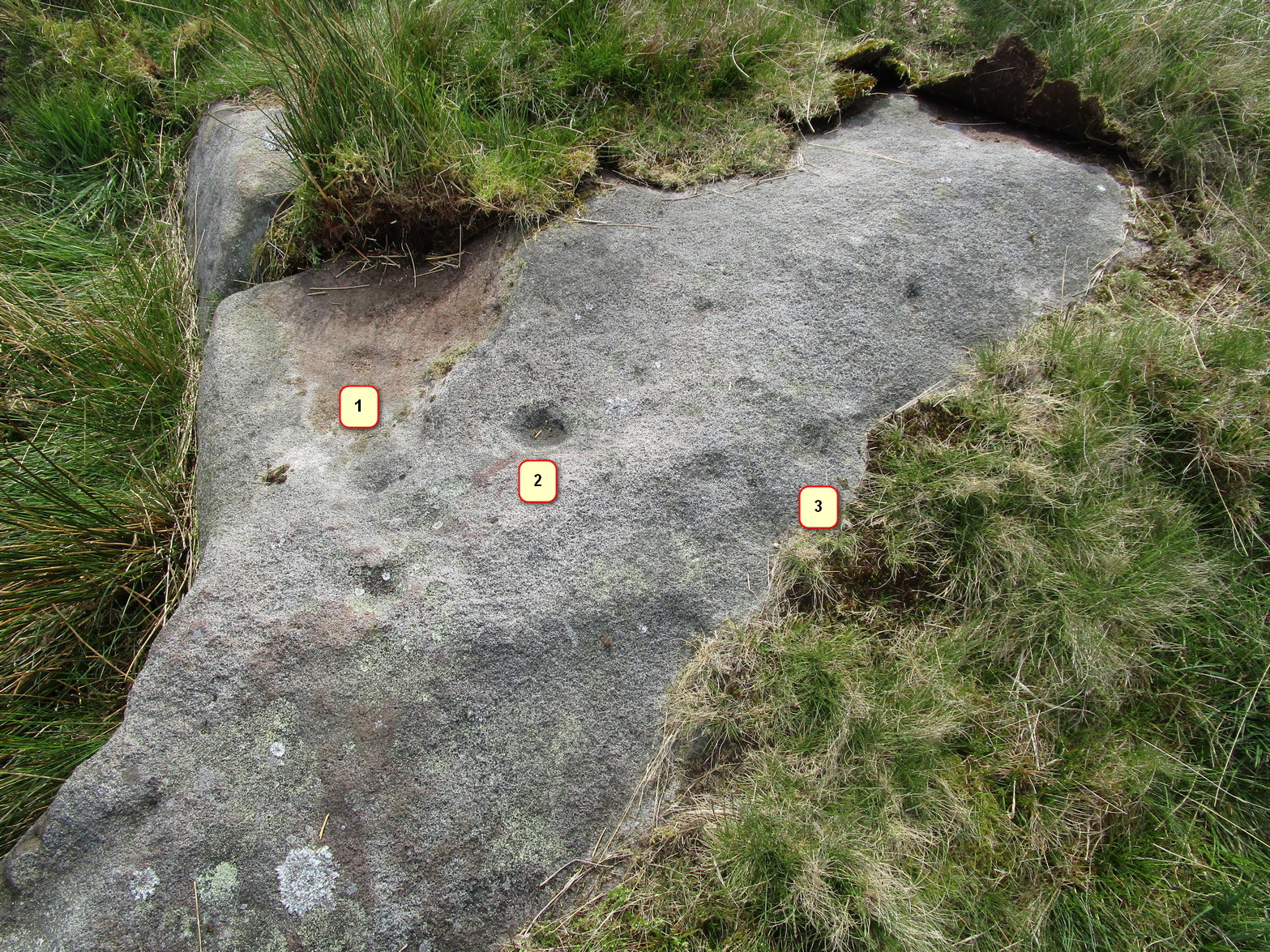
Positions of cup-marks
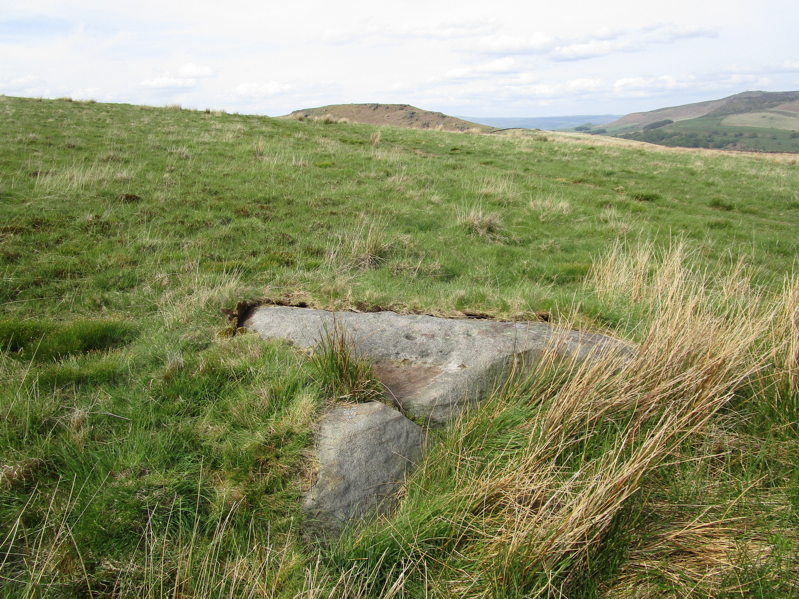
Nowt special to look at, this is merely an elongated earthfast female stone that will be hard to find when the reeds grow high. The design consists of at least three cup-marks, with the most prominent one near the middle of the stone. A second one is shallow and on its northern side, near the middle; whilst the third one on its southern side was uncovered when we peeled back the vegetation; the peck marks are still visible. In the photo to the left I’ve placed numbers below the position of the respective cup-marks. In a cursory meander here, we found no other carvings – but that doesn’t mean there aren’t any!
The quickest way to get here is to follow the directions to the Sharp Haw Trig Stone. From the Trig Stone keep heading down the footpath until you see the gate at the bottom. Go through the gate and Rough Haw is straight in front of you. Head towards Rough Haw and you will see a track going straight up the middle. Go right up that track and over the top till your on the summit, keep walking forward about 50-60 yards and you will see it.
Archaeology & History
Second lot of cups
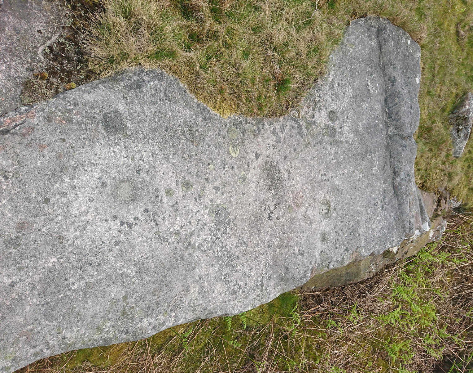
Some petroglyphs have been found near the top of the prehistoric Iron Age settlement called Rough Haw, a few miles north of Skipton. Not previously recorded, this long flat stone and its companion are littered in cup markings (perhaps a couple of dozen). There could be more cups and other markings than we saw today, but by the time we reached here the sun had disappeared, so poor daylight made it difficult to see if there were any more. Another venture up onto this hillfort might be worthwhile to see if anymore can be found.
On the A65 road from Skipton to Gargrave, just at the eastern end of Gargrave, take the small Eshton Road running north over the canal. Go through Eshton itself, making sure you bear right at the small road a few hundred yards past the old village. Keep your eyes peeled a few hundred yards down as you hit the river bridge and stop here. Just 50 yards before this is a parking spot where some Water Board building stands. Walk back up the road barely 20 yards and you’ll see, right by the roadside, a small clear pool on your left, encircled by trees. Go through the little stile here and you’re right by the water’s side!
Archaeology & History
This is actually a listed monument (unusual for wells up North!), just off the roadside between Nappa Bridge and Eshton Hall. Two or three old stone heads (deemed to be ‘Celtic’ in age and origin, though I had my doubts) have recently been stolen from this holy pool close to where the water emerges from the ground, just beneath the surface. You can see where the water bubbles up strongly from the Earth when you visit here, forming the small pool in front of it, around which at certain times of year people still attach ‘memaws’ (an old word for ritual ‘offerings’) on the small shrubs. If you drink from here, just where the water bubbles up (careful not to fall in!), it’s freezing — but tastes absolutely gorgeous! And better than any tap-water you’ll ever drink!
Mentioned briefly in Mr Hope’s (1893) fine early survey; the earliest description of this site in relation to the mythic ‘Helen’ dates from 1429, where T.D. Whitaker (1878) described the dedication to an adjacent chapel, long gone. Whitaker’s wrote:
“…One of the most copious springs in the kingdom, St. Helen’s Well fills at its source a circular basin twenty feet in circumference, from the whole bottom of which it boils up without any visible augmentation in the wettest seasons, or diminution in the driest. In hot weather the exhalations from its surface are very conspicuous. But the most remarkable circumstance about this spring is that, with no petrifying quality in its own basin, after a course of about two hundred yards over a common pebbly channel, during which it receives no visible accession from any other source, it petrifies strongly where it is precipitated down a steep descent into the brook. To this well anciently belonged a chapel, with the same dedication; for in the year 1429, a commission relating to the manor of Flasby sat “in capella beate Elene de Essheton; and on the opposite side of the road to the spring is a close called the Chapel Field. This was probably not unendowed, for I met with certain lands in Areton, anciently called Seynt Helen Lands.”
When the old countryman Halliwell Sutcliffe (1939) talked of this healing spring, his tone was more in keeping with the ways of local folk. Sutcliffe loved the hills and dales and old places to such an extent that they were a part of his very bones. And this comes through when he mentions this site. Telling where to find the waters, he continued:
“Its sanctuary is guarded by a low mossy wall. Neglected for years out of mind, it retains still clear traces of what it was in older times. An unfailing spring comes softly up among stones carved with heart-whole joy in chiselling. Scattered now, these stones were once in orderly array about what is not a well, in the usual sense, but rather a wide rock-pool, deep here and shallow there, with little trees that murmur in the breeze above. Give yourself to this place, frankly and with the simplicity is asks. It does not preach or scold, or rustle with the threat of unguessed ambushes among the grassy margin. Out of its inmost heart it gives you all it knows of life.”
Old well in the field
In the field across the road where the chapel was said to have been, we find another stone-lined fresh-water well bubbling from the ground into a stone trough (at grid-ref SD 93118 56958). The waters here are also good and refreshing. But whether this fine water source had any tales told of it, or curative properties (it will have done), history has sadly betrayed its voice.
Folklore
The waters here have long been reputed as medicinal. R.C. Hope (1893) said “this well was a certain cure for sore and weak eyes.” Whitaker and others told there to be hangings of rags and other offerings (known in Yorkshire as ‘memaws’). Sutcliffe described,
“The pilgrims coming with their sores, of body and soul… The Well heard tales that were foul with infamies of the world beyond its sanctuary. Men came with blood-guilt on their hands, and in their souls a blackness and a terror. Women knelt here in bleak extremity of shame. The Well heard all, and from its own unsullied depths sent up the waters of great healing. And the little chant of victory began to stir about the pilgrims’ hearts…and afterwards the chant gained in volume. It seemed to them that they were marching side by side with countless, lusty warriors who aforetime had battled for the foothold up the hills. And, after that, a peace unbelievable, and the quiet music of Helen’s Well, as her waters ran to bless the farmward lands below. All this is there for you to understand today, if you will let the Well explain the richness of her heritage, the abiding mystery of her power to solace and to heal.”
And so it is with many old springs… The rite of memaws enacted at St. Helen’s Well is a truly archaic one: whereby a person bringing a cloth or stone or coin — using basic principles of sympathetic magick — asks the spirit of the waters to cleanse them of their illness and pass it to the rags that are tied to the adjacent tree; or perhaps some wish, or desire, or fortune, be given in exchange for a coin or something if personal value. The waters must then be drunk, or immerse yourself into the freezing pool; and if the person leaving such offerings is truly sincere in their requests, the spirit of the water may indeed act for the benefit of those concerned.
Such memaws at St. Helen’s Well are still left by local people and, unfortunately, some of those idiotic plastic pagans, who actually visit here and tie pieces of artificial material to the hawthorn and other trees, which actually pollutes the Earth and kills the spirit here. Whilst the intent may be good, please, if you’re gonna leave offerings here, make sure that the rags you leave are totally biodegradable. The magical effectiveness of your intent is almost worthless if the material left is toxic to the environment and will certainly have a wholly negative effect on the spirit of the placehere. Please consider this to ensure the sacred nature of this site.
…to be continued…
References:
Hope, Robert Charles, Legendary Lore of the Holy Wells of England, Elliott Stock: London 1893.
Smith, A.H., The Place-Names of the West Riding of Yorkshire– volume 6, Cambridge University Press 1961.
Sutcliffe, Halliwell, The Striding Dales, Frederick Warne: London 1939.
Whelan, Edna, The Magic and Mystery of Holy Wells, Capall Bann: Chieveley 2001.
Whelan, Edna & Taylor, Ian, Yorkshire Holy Wells and Sacred Springs, Northern Lights: Dunnington 1989.
Whitaker, T.D., The History and Antiquities of the Deanery of Craven, Joseph Dodgson: Leeds 1878.
Travel up the B6265 (Skipton to Grassington road) for a mile, watching on the small hills on your left (western) side, and then take the left turn up to Sandy Beck. You can’t miss the place!
Archaeology & History
Rough Haw, looking west
My first view of this place was from the hills east of here, atop of one of the great rock outcrops on the edge of Embsay Moor. The very first impression it gave me was – “That’s a bloody hillfort!”: an obvious worked rounded hill, with ridges typical of such monuments. Subsequent investigation found that there were extensive remains of walling, more typical of the Iron Age period than the neolithic (which some modern archaeologists have proposed), clearly visible around the edges of this great hill. The structure of the site is similar in size and design to the remains at the nearby Horse Close Hill above Skipton, aswell as another (officially unknown) site closer to Keighley. A large overgrown cairn rests on the southern side of the hill, seemingly more of archaic import than a mere clearance or marker point. But I may be wrong…
Very notable at this site are the profusion of springs emerging from all round Rough Haw: the blood of seven such water sources comes from its edges on all sides and would obviously have been of some importance here.
References:
Dixon, John & Phillip, Journeys through Brigantia – volume 1: Walks in Craven, Airedale and Wharfedale, Aussteiger Publications: Barnoldswick 1990.
There are several ways to get here, but I took the one from the road (B6265) walking up the track into Crookrise Woods. Unless you’ve got a decent OS-map with it marked on, this might take some finding to some folk as it’s tucked away on the northern edge of Crookrise Woods (which one Southerner bloke told us was private – though he was ‘allowed’ there!). It’s right on the rounded knoll at the top of the woods, beneath the prominent slopes which lead to the moor.
Archaeology & History
Our old mate and Yorkshire historian Arthur Raistrick seems to have been the first to describe this place in the Yorkshire Archaeological Register of 1964 – though the holy wells writer Edna Whelan told me she knew about the place many years back. Today hidden in woodland and mostly overgrown, Raistrick’s brief description of the place said:
“A small stone circle of six stones set symmetrically within a diameter of 26 feet. The stones vary in size from 21 to 58 inches. Surveyed 1963.”
The site has been badly affected by the erosion of time, forestry and god-knows what else. Scattered around are numerous small stones giving the impression that it may once have been a cairn-circle, more than a stone circle. Four of the six stones mentioned by Raistrick (1965) are visible, but none are impressive – and unless you’d read about the place first or found it in Mr Burl’s Stones Circles of Britain… (2000), you wouldn’t really give it the time of day.
Although sadly disappointing in its present status – completely surrounded by trees, with no view at all – it seems probable that it would have had some geomantic relationship with the hillfort-looking site of Rough Haw immediately west, and very probably the adjacent ritual site of Sharp Haw. It seems that the equinox sun would set between Rough Haw and the other small rounded hill above.
References:
Burl, Aubrey, The Stone Circles of Britain, Ireland and Brittany, Yale University Press 2000.
04")
06")

