Similar in size and appearance to one of the cup-marked Tuilyies standing stones in Fife, Scotland, it was our old ley-hunter, Alfred Watkins, who described this stone in his Ley Hunter’s Manual (1927), along with giving us the old photograph taken by one of his mates here, which also showed the cup-and-ring carvings near the base of the stone. Are they still visible? (I’ve not been here, hence mi ignorance!) Watkins thought the cup-markings at the bottom represented some of the local leys—but unfortunately they don’t.
Folklore
Legend says that the deep grooves running down the stone were made by men sharpening arrow-heads on it (like a whetstone). There was also the usual christian Victorian fable that the stone was used by the druids and that the grooves on the stone were where the blood of their human sacrifices was channelled to the ground! The stone was also said to have some relationship with the nearby Calder Stones (which seems probable).
References:
Cowell, Ron, The Calderstones – A Prehistoric Tomb in Liverpool, Merseyside Archaeological Trust 1984.
Watkins, Alfred, The Ley Hunter’s Manual, London 1927.
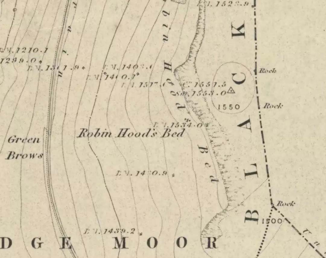
Follow the same directions to get to the Aiggin Stone. Once here, go over the stile by the fence opposite towards the great geological ridge less than half-a-mile south. Head for the triangulation pillar right on the top of the ridge, and there, about 20 yards past it, higher-up than the triangulation pillar at the very top of Blackstone Edge, is Robin Hood’s legendary stone bed!
Archaeology & History
Robin Hoods Bed, looking north
There’s very little of archaeological interest known up here, save a mass of flints and scrapers that have been found scattering the moorland heights hereby, from the mesolithic period onwards. But we have a relative lack of neolithic to Iron Age remains — officially anyhow! A possible standing stone can be found a few hundred yards south, but there’s little else.
The rock that’s given its name to Robin Hood’s Bed overlooks the very edge of the ridge, detached from the main section, with a large and very curious nature-worn ‘bed’ on its very crown, more than 4 feet wide and about 7 feet long, into which one comfortably lays. It was named in the boundary records of the township of Rishworth in 1836, where it describes other historical stones, saying:
“thence under Robin Hood’s Bed to a stone marked ‘W.S.G.S. 1742, 1770, 1792, and the following figures and letters, ‘1826 I.L.S.'”
Folklore
This enormous millstone grit boulder, sitting 1550 feet upon the high moors is, according to legend, a place where our famous legendary outlaw once slept. Whilst sleeping here, some of his followers were said to have kept guard and looked over him.
Robin Hood’s Bed, from below
A rather odd piece of folklore recited by Jessica Lofthouse (1976) is that “no winds ever blow” at Robin Hood’s Bed, who then went on to tell of the time she visited the place. Walking along the rocky ridge where the stone bed is found, the winds were such that “we had almost been blown over the edge,” until just a few hundred yards further when they eventually reached the fabled site, Nature granted them a sudden calmness unknown to all the high moorlands around, affirming the curious folklore.
The ceremonial stone ‘bed’
Robin Hood’s Bed itself was undeniably an important ceremonial site for both rites of passage and ritual magick to our indigenous ancestors. The place screams of it! It also seems very likely that the hero figure of Robin Hood replaced an earlier mythological character, akin to the fabled female creation deity, the cailleach, found commonly in more northern and Irish climes, whose echoes can still be found around our Pennine hills. For we find that Robin Hood was said to have taken a large boulder from here and with a mighty heave threw it six miles across the landscape due west into the setting sun, where it eventually landed at Monstone Edge, near Rochdale! Local people were so astounded at this feat that the stone was given the name of Robin Hood’s Quoit.
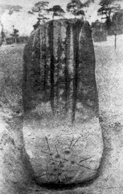
7ft tall natural standing stone
The old place-name authority Eilert Ekwall (1922) related the folklore that the giant ridge of Blackstone Edge “is said to refer to a boundary stone between Yorkshire and Lancashire.” Which may be the curious upright standing stone, more than 7 feet tall, less than 50 yards NNE which gives a very distinct impression of having been deliberately stood upright, amidst this mass of loose geological droppings! It would be helpful if there was a geologist in the house who could tell us decisively one way or the other…
Another etymological possibility that has been posited relates to the word ‘bed’ at this site. Ordinarily it would be sensible to attach the word to the great stone ‘bed’ atop of the poised boulder. But with the attached legends symptomatic of prehistoric monuments, it would not be improper to highlight that the old Welsh word ‘bedd‘ (a place-name element that is not uncommon in Lancashire) means, “a grave or tomb”. And this site would be ideal for such an old prehistoric cairn…
References:
Bennett, Paul, The Old Stones of Elmet, Capall Bann: Milverton 2001.
Ekwall, E., The Place-Names of Lancashire, Manchester University Press 1922.
Lofthouse, Jessica, North Country Folklore, Hale: London 1976.
Smith, A.H., The Place-Names of the West Riding of Yorkshire – volume 3, Cambridge University Press 1961.
If you follow the directions to reach the Churn Milk Joan stone, then continue onto the moor following the same directions to find the Miller’s Grave, once you’ve reach this you’ll see a large rounded boulder a couple of hundred yards away on your left, to the northwest. That’s Robin Hood’s Penny Stone!
Archaeology & History
Robin Hood’s Pennystone, Midgley Moor
In terms of this site’s archaeology, it has none to write home about in official records (other than a few flints found nearby), but there’s more to this place than meets the eye. A large rounded boulder sat upon the moorland plain with a large Nature-worn bowl on its top, the site is some 112 yards (102m) northwest of the little-known, but impressive Miller’s Grave prehistoric cairn (close to being a midsummer/midwinter line). North and south of the rock are small lines of prehistoric walling — though their context is difficult to assess. The Greenwood Stone and Greenwood B stone can be found about 200 yards west.
Folklore
A singular footpath once led up to this old boulder, atop of which – in its large ‘bowl’ – vinegar used to be poured. In this, coins were left by local people who suffered the plague and in return food was left for them. And of course it is said that Robin Hood frequented the place in bygone times.
References:
Bennett, Paul, The Old Stones of Elmet, Capall Bann: Milverton 2001.
Robert, Andy, “Our Last Meeting,” in NEM 37, 1989.
Robert, Andy, Ghosts and Legends of Yorkshire, Jarrold: Sheffield 1992.
Along the Brighouse to Mirfield A644 road, a half-mile east of M62’s junction 25 on Wakefield Road, note the woodland on your left-hand side, above the walling. Although on allegedly private land, you can approach by hopping over the wall by the main road into the woods. Wander up the slope until it levels out and, just at the edge of the tree-line, past the brilliant overgrown folly amidst a mass of rhododendrons, you’ll see the denuded edges of this earthwork. Though you might need a bitta patience seeking it out…
Archaeology & History
Very first sketch of this site (John Watson, 1775)
The remains of this low earthwork is found on the private land of Kirklees Hall and appointment is supposed to be made to explore, both this and the more famous Robin Hood’s Grave, a few hundred yards away. But if you can’t be bothered with that and find this little-known earthwork, you’ll see that it’s roughly squared in shape, though pretty overgrown. In Bernard Barnes’ survey (1982) he described it as a “square or five sided enclosure, 2-3 acres in size, with bank and external ditch”, wondering whether it was used to enclosure cattle and stretching its possible origin between the Iron Age to the medieval.
Although the classical Roman archaeologist Ian Richmond (1925) believed the site to be from that period, the archaeologist J.J. Keighley thought that the site was “more likely to be Iron Age than Roman.” He wrote:
“The earthwork in Kirklees Park is a square or five-sided enclosure with bank and external ditch… The site lies on Richmond’s trans-Pennine route. According to Armitage and Montgomerie, the earthwork is 0.5 hectares in area, but it is actually nearer 0.8 to 1.2 hectares. They compare its construction with the fort at Wincobank (South Yorkshire), stating that the bank on the counterscarp when excavated, revealed “a very rudely composed wall of undressed dry stone.”
Earlier local writers such as John Watson (1775) — whose early sketch of the site is reproduced above — and others also opted for the Roman date. But, unless you’re a bit of an earthwork fanatic, this site may not be too much your cuppa tea. If you are gonna check this out though, make sure you check out Robin Hood’s old tomb in the trees not far away. Very odd.
References:
Barnes, Bernard, Man and the Changing Landscape, Merseyside County Council & University of Liverpool 1982.
Keighley, J.J., “The Prehistoric Period,” in West Yorkshire: An Archaeological Survey to AD 1500 (WYMCC: Wakefield 1981).
Richmond, I.A., Huddersfield in Roman Times, Tolson Memorial Museum: Huddersfield 1925.
Watson, John, The History and Antiquities of Halifax, J. Lowndes: London 1775.
From Bakewell take the A6 Matlock road, follow this till just past the signs for Haddon Hall where you take a right (the first major junction) for Youlgreave the B5056. After about 1km take the first left over the bridge. You then take the first right turn: a steep lane with restriction signs (don’t worry there’s access for cars but no wide vehicles). Take the first left you come to by the barn and then just follow the road, up through the woodland where the lane narrows then shortly after you’ll see Robin Hood’s Stride to your left. Park a little way after the field gateway and look across the field to your left. The stones are visible from the road.
Archaeology & History
This is a fine-looking ring of stones — though perhaps the word ‘ring’ is slightly misleading here, as only four of (apparently) nine originals still remain and they are, by definition, more in a square-shape than a circle! But it’s a lovely site. When Geoff brought us here for the first time only last weekend, despite the dark clouds and cold grey day, along with the fact that we’d been sleeping rough the night before and got soaking wet through, there was a subtle feel to this place which my shivering senses still touched. Only just though…!
Two southernmost stones
Mebbe it was the rising crags of Robin Hood’s Stride to its immediate south? Or the quietly hidden companionship with other stones and sites in the locale? I don’t really think so. There was something a little more about its own genius loci that tingled very slightly on the rise in the field upon which the circle sits. Some people would, perhaps, acquaint my sense of a subtle genius loci here to the various leys or ley-lines that have been drawn through here by other writers— but it wasn’t that.
When earlier writers came here, they too had various inspirations of differing forms. John Barnatt’s (1978) early impressions of the place had him signing astronomical events in and around the remaining stones here, despite knowing that the site had been damaged. In later years he revised his early notions — as most of us do as our perspectives are enriched — but the astronomy is still assumed here. As Clive Ruggles (1999) told:
“Other rings are located where natural features coincide with astronomical events, such as Nine Stone Close in Derbyshire…from which the Moon at the southern major standstill limit, sets behind the gritstone crag of Robin Hood’s Stride to the SSW, between ‘two stubbly piles of boulders jutting up at either end of its flat top.'”
Major Rooke’s drawing of the Nine Stones Circle, c.1780
The stones that remain here are quite tall, between 6½ and 8 feet tall. One of them seems to have originally been taken from a stream or river-bed. They stand upon the small rise in the field and has diameters of 40 and 45 feet respectively. Aubrey Burl described there being seven uprights still here in 1847, and the early drawing of the site near the end of the 18th century by Major Hayman Rooke highlights 6 stones around the spot where the circle now stands. In J.P. Heathcote’s (1947) summary, he wrote that,
“Bateman, in his Vestiges, says an excavation in 1847 yielded some indications of interments in the form of ‘several fragments of imperfectly-baked pottery, accompanied by flint both in a natural and calcined state.’ In 1877, Llewellyn Jewitt and Canon Greenwell…turned their attention…to the Nine Stones. They dug at the foot of the second highest stone and the Canon directed a good deal of digging within the circle, but nothing special turned up. The area in the circle is now quite level, but it is probable that there was, as Bateman says, a tumulus in the centre.”
This latter remark is the impression I got of the place. Tis a really good little site. All around here are a number of other sites: cup-marked stones, enclosures or settlements, prehistoric trackways, and more.
Folklore
One of the old names of this site was The Grey Ladies. This came from the well known tale found at other sites across the world, that some ladies were dancing here at some late hour and were turned into stone. A variation on this theme told how Robin Hood stood on the nearby rock outcrop to the south and pissed over the landscape here, “where seven maidens upon seeing it turned to stone.” In this case, Robin Hood replaced an older, forgotten account of a giant, who forged the landscape and the sites around Harthill Moor.
Another tale — whose origins and nature are allied to that of the petrification of the Grey Ladies — narrated with considerable sincerity by local people, was that the circle was a place where the little people gathered and where, at certain times of the year, “fairy music and the sight of hundreds of dancing shapes around the stones” would happen.
Said by Rickman and Nown (1977) to be “Derbyshire’s most magical ancient site,” they thought the site was on a ley that linked up with Arbor Lowe, less than 5 miles west, crossing a couple of tumuli on its way.
References:
Barnatt, John, Stone Circles of the Peak, Turnstone: London 1978.
Burl, Aubrey, A Guide to the Stone Circles of Britain, Ireland and Brittany, Yale University Press 1995.
Clarke, David, Ghosts and Legends of the Peak, Jarrold: Norwich 1991.
Heathcote, J. Percy, Birchover – Its Prehistoric and Druidical Remains, Wilfrid Edwards: Chesterfield 1947.
Rickman, Philip & Nown, Graham, Mysterious Derbyshire, Dalesman: Clapham 1977.
Ruggles, Clive, Astronomy in Prehistoric Britain and Ireland, Yale University Press 1999.
Thom, A., Thom, A.S. & Burl, Aubrey, Megalithic Rings, BAR: Oxford 1980.
Dead easy! If you come from Silsden, take the Holden Road up onto the moor edge, all the way up the wooded hill. As you reach the top, keep your eyes peeled for the stone in the slope to your left. Otherwise, coming from Riddlesden, take the moor road upwards (to Silsden Road) as if you’re gonna visit Peggy Mawson’s Well, the Baldwin Stone or some of the Rivock carvings. Keep on the road to where you see the microwave tower on Pinfold Hill to your right. It’s just below it!
Archaeology & History
Robin Hood’s Stone from above
Flints have been found on the slopes above here, but records of this stone only go back — as far as I’ve found — to 1850 (this seems to typify records around the Keighley district, which only seems to record anything post-1500 AD). In mid-Victorian times, plans were afoot to use the rock for building material, but local people objected and so the stone kept its position overlooking the valley. There are a number of very defined ‘cups’ on the sloping face of the stone, but several (though not all) of these have all the likeness of the holes dug into the rock by climbers — though why climbers would even think to cut foot-holes into this easy rock beggars belief!
Folklore
One of several sharp well-defined ‘cups’ on the rock
Not too surprisingly, folklore tells that this stone was one of the places where our old hero Robin Hood sheltered, when being chased by god-knows-who in one of his many exploits. We’ve no way of proving this of course, but the sparse woodland remains above here also bear the hero’s name. What seems to be a more modern piece of industrial folklore alleges that this stone was actually put here by workers in the Victorian times! The boulder allegedly lived near Barden, Bolton Abbey, but was blocking construction work, so was uprooted and moved all the way to where it now sits! In bygone times the rock was a local meeting place – perhaps around Beltane, in line with Robin Hood festivities.
References:
Gray, Johnnie, Through Airedale from Goole to Malham, Elliot Stock: London 1891.
Follow the same directions to reach the Robin Hood’s Wood Stone, but head from there to the dirt-track about 30 yards away. This stone is just 10-15 yards on the south-side near the bend in the track. Look around!
Archaeology & History
Holden Cup-Marked Rock
If you can find this stone, the 2-cupped Robin Hood’s Wood Stone carving is only about 15 yards SW. But this poor example is a mere single cup-mark sitting near the centre of a large flat rock, half-covered in vegetation like its nearby compatriot. There’s a faint possibility of a second cup-mark on the rock, but it’s pushing it a bit! Thanks to the vegetation cover on the majority of the rock, the cup’s in a good state of preservation. Nowt much to shout about unless you’re a real cup-and-ring nut!
Follow the same directions for reaching the Baldwin Stone. From here, with your back to the wall, face the small remnants of Robin Hood’s Wood and walk straight to where the game-keeper’s stuff is in the trees 150 yards straight in front. Go through the small copse and out the other side, in a straight line for another 70 yards. This stone’s mainly covered over with vegetation (and we covered most of it back over again) so you might have trouble finding it. But with patience and a good nose, you’ll find it hereabouts!
Archaeology & History
Robin Hood’s Wood Cup-Marks
Another previously undiscovered carving, found yesterday (12.6.09) by Michala Potts after rummaging for sometime amidst the mass of Juncus grasses which cover the plain immediately north of Robin Hood’s Wood. Not much to see unless you’re a real rock-art freak, as we only have two definite cup-markings on the stone. A possible third cup can be seen closer to the NW edge, where the rock becomes more crystalline.
I was rather intrigued by Mikki’s find, as when she shouted me over, found that she’d rolled much of the vegetation back that had been covering the stone. Without rolling the grasses back from the surface, she wouldn’t have found the cup-marks; and considering the number of stones that scatter this plain, I asked why she’d chosen to uncover this one and not the others.
“It told me to!” she said in that blunt Yorkshire way.
From East Riddlesden, go up the road (over the swing-bridge) that takes you onto the moor-edge (ask a local if you have trouble). Go all the way up till you hit the road which encircles the moor (it’s called the Silsden Road where you hit it). Turn left for several hundred yards till you see the microwave tower just on the hillock to your right on Pinfold Hill (not the larger TV towers just below the forest). Walk up there, then follow the edge of the walling till you hit the old Pinus sylvestris trees of Robin Hood’s Wood where 2 walls meet. Go over the gate and walk to your right for about 200 yards, following the line of the walling. You’re there!
Archaeology & History
Cluster of cups on W edge
A newly-discovered cup-marked stone, located for the first time on Tuesday, June 9, 2009, by Michala Potts, who was out on an amble with some long-haired halfwit whizzing about getting excited about stupid cup-markings on stones, dragging her back and forth and leaving her in the middle of a bog! On one occasion when this ‘ere fruitbat wandered off (again!), leaving her alone in the middle of the hills, she decided to check out some rocks a bit further up the slope where she’d been left alone. And there, along the edge of some walling, right on the edge of the much-denuded Robin Hood’s Wood, a short distance west of Rivock, a curious stone popped out and caught her attention!
Was this a cup-marking she saw before her!? It certainly was! But she didn’t call out to this halfwit who’d left her to her own devices. She let him just wander off to his sad heart’s content, whilst she got into the nitty-gritty of checking the stone out, uncovering the essentials of the carving while he bimbled off like a freak! And what a nice carving it was she found…
Baldwin Stone – looking westFirst sketch of the stone
Although no accurate measurements were made of the stone (it was bigger than 10-inch!), at least 17 cup-markings were counted here: one singular and very well-preserved cup, alone on its southern edge, right by the walling. But the main feature of the design is a cluster of cup-marks (at least 11) on the western side of the rock — one part of this cluster having the appearance of the figure 5 on a dice! Several other well-defined cups occur on the central and more northern end of the rock.
Eventually, her sad stone-wandering fella returned, forlorn, having found no new carvings of his own (poor soul!). And so she took his poor little hand, and took him to see the little prehistoric treasure she’s uncovered — and her sad little man got all smiley and … well, you know what they’re like!
Additionally however, for the archaeo’s amongst you: if you come wandering up here to check this carving out, you’ll notice the remains of many large upright stones in a lot of the old stone walls round here. Many of these are the remains of Iron Age walling.
From the village of Midgley, high above the A646 Halifax-to-Todmorden road, travel west along the moorland road until you reach the sharp-ish bend in the road, with steep wooded waterfall to your left. From here, across the road (roughly) there’s a track onto the moor. Go up this, keeping to the line of the straight walling uphill by the stream-side (instead of following the path up the quarries) all the way to the top. Here you’ll see the boundary stone of Churn Milk Joan. Take the footpath to its side for up onto the moor 250 yards or so, taking a right turn into the deeply cut footpath and walk along for several hundred yards, keeping your eyes to the north (right). You’ll see the rocky cairn of Miller’s Grave not far away in the heather, near to the large rounded boulder known as Robin Hood’s Pennystone.
Archaeology & History
Ascribed by some as neolithic, and others as Bronze Age (the more probable), here is a curious archaeological relic: curious, inasmuch as it’s received very little attention from archaeologists. It’s quite a large monument — and perhaps the fact that it has always seemed to be in isolation from other prehistoric remains has held it back a little. But recent ventures here have brought about the discovery of more cairns (though singular small ones), neolithic walling, hut circles and other prehistoric remains that have never previously been reported.
Miller’s Grave, Midgley Moor (in VERY heavy rain!)Central stone aligning north to Nab End
It’s a decent site aswell. Mainly consisting of the usual mass of smaller stones piled up and around one main point; in the middle of this ‘tomb’ is a large split glacial erratic boulder, which may have been the original focus of the builders. Some may even ascribe a coupla cup-markings on this ‘ere central rock form — but they’d be pushing it a bit! This large central feature aligns to the high peak of Nab Hill several miles north, above Oxenhope. Whether this feature was of any significance in the cairn’s construction is debatable (though as north represents death in pre-christian peasant lore, this ingredient has to be noted).
Profile shot – looking NELooking SE, with small cairn in foreground
The cairn is a goodly size: some 4 feet tall and about 50 foot across at its greatest diameter. Some of the stones near the centre of the stones have been put there in more recent years. In previous centuries, treasure-seekers came here in the hope that they’d uncover gold or other trinkets and stripped off much of the original cover, moving many rocks to the edges. Others were also stolen from here to make some of the grouse-butts, not far from away. In a foray to the site on 5.9.10. we were lucky to find the heather had been burnt back and found, some ten yards to the north and to the southwest, the remains of small, outlying singular cairns (though these need excavating to ascertain their precise nature).
Calderdale Council’s archaeology notes on Miller’s Grave tell it to be “situated on the summit of Midgley Moor”, which is quite wrong. The summit of the moor is some distance west of here, near where an old standing stone called the Greenwood B stone (75 yards south of the Greenwood Stone) and the much denuded remains of other prehistoric sites could once be found — though I’m not sure that they, nor the regional archaeologist for Upper Calderdale has ever been aware of them.
Folklore
In F.A. Leyland’s (c.1869) extensive commentary to Watson’s History of Halifax (1775), he relates a fascinating tale which seems to account for the name of this old tomb:
“About ninety years ago,” he wrote, “that is, towards the end of the eighteenth century – one Lee, a miller, committed suicide in Mayroyd Mill near Hebden Bridge. The jury at the inquest held on the occasion returned a verdict of felo-de-se, and the body was buried at Four Lane Ends, the Rough, in Midgley. The fact, however, of the body of one who had laid violent hands upon himself, lying in unconsecrated ground at a point where the highways met, and at a spot which the inhabitants passed early and late, oppressed the people of the neighbourhood with an irresistible dread. Persons going to market and passing from village to village, feared and avoided the unhallowed spot, until the feeling increased to one of insupportable terror; and, in the night time, a multitude collected with torches to disinter the body. This was speedily effected and violence was even offered to the dead. A man named Mark Sutcliffe, and others, who attempted to prevent the exhumation, were stoned* by the mob, and the body was hurried to the cairn on Midgley Moor, where it was hastily interred. Here however, it was not allowed to rest; the isolation of the body, though buried in a lonely spot, was yet apart from the common cemetery where the dead lie together in their special domain; and this invested the surrounding district with a superstitious awe difficult to describe. The body was still too near the haunts of the living; and, to the perturbed imagination of the inhabitants, the unquiet ghost of the suicide constantly brooded over the hills. As this was not to be endured, the body was at last removed from the cairn, and finally buried in the churchyard of St. Thomas a’ Beckett’s, Heptonstall. Although the interment of Lee, at the cairn, has conferred upon the spot the name of the Miller’s Grave, it cannot be doubted that the large quantity of heavy stones which we find heaped together at this place…was piled up in distant times…”
Modern pagan folklore ascribes the name of this site to relate to Much, the Miller’s Son: acquaintance of the legendary Robin Hood, whose ‘Penny Stone’ boulder is just 100 yards west of here.


")


")


