Take the same directions as if you’re visiting the Rivock Edge 060 Carving. It’s 25 yards NNW – you can’t really miss it!
Archaeology & History
Rivock Edge, carving 58
This large flat rock, with a couple of long lines almost splitting the rock into sections, was first mentioned as a prehistoric site in John Hedges (1986) survey, where he described it simply as, “Large rough grit rock with possible four cups, in crowberry.” Boughey & Vickerman (2003) said even less about it! One of the cups is very distinct, but the others are somewhat faded and perhaps even dubious. It’s still worth a look at, if only due to the other better carvings nearby.
References:
Bennett, Paul, “The Prehistoric Rock Art and Megalithic Remains of Rivock & District (parts 1 & 2),” in Earth, 3-4, 1986.
Boughey, Keith & Vickerman, E.A., Prehistoric Rock Art of the West Riding, WYAS 2003.
Hedges, John (ed.), The Carved Rocks on Rombald’s Moor, WYMCC: Wakefield 1986.
Takes a bitta finding unless you’ve got a GPS system, or someone like me to show you where it is! The best way’s probably via the Askwith Moor Road car park, up the road 160 yards till you hit the straight line cut into the moor on your right, where the landscape’s been damaged.* Walk along this for less than 100 yards, then walk right, through the heather and onto the singular tree roughly 200 yards away. From here, walk 75 yards (strides) north from the tree. You’re damn close!
Archaeology & History
About 20 feet from a line of ancient walling in an area pretty rich in prehistoric sites, is this medium-sized stone with a lovely cup-and-ring design. The carving was first recorded by fellow antiquarian, Eric Cowling (1937), in his short survey of other carved stones in the area. He called this ‘carving no.7’ and described it, thus:
“In the central area of Snowden Carr is a barrow group, which occupies a slight ridge running from the edge of the bog to the east, almost to the moor road on the west. The ridge is almost devoid of vegetation except at the higher end. Here, on a heather-covered boulder, is marking no.7. The cups are smaller than usual, and only one ring completely surrounds a cup. The lines linking the cups are only lightly incised, and the whole marking has a delicate appearance.”
Old photo of the carvingCowling’s 1937 sketch
I first visited this stone in the 1980s with fellow rock art student and author, Graeme Chappell, and for some reason it has always impressed me (I recall Graeme laughing whilst I made joyous noises and stroked the rock, reverentially!). Cowling’s description of the stone as ‘delicate’ is appealing, as the stone and its design has a nurturing aspect to it, female in nature. (forgive me — but many of these stones tend to capture me in such ways!) The stone was described more clinically in Boughey & Vickerman’s (2003) more recent survey, in the way that archaeologists tend to do, saying plainly:
“Fairly large, flat, smooth grit rock with crack. Up to seventeen possible cups, one with complete ring, one with partial ring, one with possible ring; connecting groove.”
Doesn’t quite capture the feel of the place, which I’m sure they’d admit. The next time I’m up here, I’ll get some better photos of the carving.
References:
Boughey, Keith & Vickerman, E.A., Prehistoric Rock Art of the West Riding, WYAS 2003.
Cowling, E.T., ‘A Classification of West Yorkshire Cup and Ring Stones,’ in Yorkshire Archaeological Journal 1940.
Cowling, E.T., Rombald’s Way: A Prehistory of Mid-Wharfedale, William Walker: Otley 1946.
Cowling, E.T. & Hartley, C.A., ‘Cup and Ring Markings to the North of Otley,’ in Yorkshire Archaeological Journal 33, 1937.
ACKNOWLEDGEMENTS: Huge thanks to one of my fine ladies, Inmaculada Ibanez-Sanchez, for the drawing! Cheers Inma!
* A pipeline was laid across the moor here, and subsequent work (I presume by the same company) was done again in early 2011, cutting through and damaging several prehistoric monuments and destroying at least one prehistoric cairn. An archaeological survey of the region should have been done before any work proceeded here, but I’m unaware of any such excavations, or archaeological reports preceding or concurrent to the ecological and historical damage performed.
Take the A6034 road between Addingham and Silsden and, at the very top of the hill between the two towns, at Cringles, take the small road of Cringles Lane north towards Draughton. Less than a mile on, veer to left and go along Bank Lane until you reach the track and footpath on your right that takes you to Moorock Hall. On the other side of the Hall, take the track on your left, along the wallside; and where the track turns left again, look into the field on the other side of the wall. You can see some of the ditch and embankment running across the field.
Archaeology & History
Found within the southwestern segment of the gigantic Counter Hill enclosure, near Woofa Bank, Eric Cowling (1946) described “an almost obliterated fortification” which has certainly seen better days — though you can make out the ditched earthwork pretty easily at ground level. When T.D. Whitaker visited this place sometime before 1812, he described it as a camp that “was found to contain numbers of rude (?!?) fireplaces constructed of stone and filled with ashes.” He also thought the enclosure was Roman in nature.
Western line of embankment
It’s a large site. Running around the outer edge of the embankment, this enclosure measures roughly 378 yards (345m) in circumference. It has diameters measuring, roughly east-west, 132 yards (121m); and north-south is 95 yards (87m). The ditch that defines the edges of the enclosure averages 6-7 yards across and is give or take a yard deep throughout — but this is not an accurate reflection of the real depth, as centuries of earth have collected and filled the ditch. An excavation is necessary to reveal the true depth of this. There also seems to have been additional features constructed inside the enclosure, but without an excavation we’ll never know what they are. Examples of cup-marked stones can be found nearby.
The Marchup Hill enclosure was described by the early antiquarian James Wardell (1869), who visited this and the other earthworks around Counter Hill. He told that this was,
“of oblong form, but broadest at the west end, and rather larger than the other. When the area of this camp was broken up, there were found some numbers of rude fireplaces constructed of stone and filled with ashes, and also a large perforated bead of jet.”
E.T. Cowling’s plan
Modern opinion places the construction of this enclosure within the Iron Age to Romano-British period, between 1000 BC to 300 AD. E.T. Cowling (1946) thought the Iron Age to be most likely, but it may indeed be earlier. His description of the site was as follows:
“At the foot of the southern slope of Counter Hill and close to the head waters of Marchup Beck is an almost obliterated fortification. These remains are roughly rectangular, but one side is bent to meet the other; the enclosure has rounded corners and has a ditch with the upcast at each side. The inner area is naturally above the level of the surrounding ground. In spite of heavy ploughing, the ditch on the western side still has a span of fifteen feet and a depth of five feet between the tops of the banks. Whitaker states that the camp “was found to contain numbers of rude fireplaces constructed of stone and filled with ashes.” These hearths appear to be the remains of cooking-holes such as are often found on Iron Age sites… Cup and ring markings are close at hand, but no flints have been found or trace of Mid-Bronze Age habitation. The enclosure is badly planned, the upcast on the western side would aid an attack rather than the defence.”
…to be continued…
References:
Cowling, Eric T., Rombald’s Way, William Walker: Otley 1946.
Wardell, James, Historical Notes of Ilkley, Rombald’s Moor, Baildon Common, and other Matters of the British and Roman Periods, Joseph Dodgson: Leeds 1869. (2nd edition 1881).
Whitaker, Thomas Dunham, The History and Antiquities of the Deanery of Craven in the County of York, (3rd edition) Joseph Dodgson: Leeds 1878.
We know very little about the site that once stood here — even Aubrey Burl (2000) found no history here. It seems that antiquarian records were never made in this outlying district and even folklore records seem to have missed this region! (surely not?) A. Lindsay Mitchell (1992) told that the circle here had been built into the church, but knew no more.
First described in the old Statistical Account of Scotland in 1794, even then it was in the past tense, as they said that “a Druidical temple is said to have stood in the vicinity of Balkethly. Not the smallest vestige can now be seen.” Balkaithly Farm is a few hundred yards east of Dunino. In the New Statistical Account of the region in 1845 it was reported that three stones close to the west wall of the minister’s garden at Dunino were said to be part of the ruined circle. The site had truly gone. By 1925 when the Royal Commission (1933) lads visited the place to look for any remains, they told:
“The stone circle which formerly existed near the church at Dunino has now been entirely destroyed, but what are believed to be portions of some of the original stones are built into the dyke on the north side of the roadway at the south-west of the churchyard, about 100 yards east of its junction with the main thoroughfare to St. Andrews.”
A few hundred yards west of the circle, “a short cist containing a fine food-vessel urn was accidentally discovered during ploughing on the farm of Beley.” This was sent to Edinburgh’s National Museum.
Folklore
Locally, there are several places alleged to have been the actual spot where the circle once stood. Several stones within nearby Dunino church have typical Mason marks carved on them which, local folklore says, identifies them as coming from the circle and then subsequently being built into the church. Also in the churchyard is a small carved upright stone, which local people visit and leave offerings upon.
References:
Batchelor, Richard A., Origin of St. Andrews: Moon, Magicians and Maidens in Fife, Shieling: St. Andrews 1997.
Burl, Aubrey, The Stone Circles of Britain, Ireland and Brittany, Yale University Press 2000.
Follow the same directions as if you’re going to the excellent Morphing Stone cup-and-ring carving. From the carving, look up the field to the where the dirt-track is and, by the closest gate with a tree near it, walk straight towards it. Roughly halfway between the Morphing Stone and the gate you’ll find — eventually — the small stone in the photo with well-defined cups on it. You might need to wander back and forth until you find it, as there’s many rocks to check out here!
Archaeology & History
Possible cup-marked rock
This small cup-marked stone was rediscovered by Danny Tiernan in the late afternoon of Thursday, August 18, 2011, just as the heavens opened and the rains poured down! With at least one well-defined cup-mark and another two near the edge of the stone where the grasses had grown, this stone probably needs another look at it, as there may be more beneath the surface, much like when we first found at Morphing Stone.
Danny also found and photographed another larger boulder, a bit further up the field closer to the fence, where what may be a single cup-mark is clearly seen living on top of the rock. It’s one of those dodgy English Heritage ones though, so I’ll let those ‘qualified’ chaps check this one out and give it their expertise! It could well be another unrecorded cup-marked stone though…
Follow the same directions as if you’re visiting the Apronful of Stones giant cairn, above Giggleswick. Walk past the giant cairn for a coupla hundred yards until you reach the large section of fallen walling, which you can clamber over and head towards the small rise of the Sheep Scar enclosure 100 yards in front of you. Walk to the far end of this walled enclosure and look down the slope to your left, for 50-60 yards where you’ll see a small rocky mound rising above the edge of the hollow footpath. That’s it!
Archaeology & History
This lovely old overgrown prehistoric cairn seems to one of what were once the remains of many other old tombs that scattered this grassy rocky plain, on the western ridge between Stainforth and Settle. Although there are what seems to be the remnants of others nearby, this particular stone heap, its edges buried beneath centuries of earth, is a fine little-known specimen that deserves attention after so long a period in the sleep of ignorant moderns. The cairn is found within an area that Harry Speight (1892) called the “Field of the Dead”, where he came across “traces and remains of human graves which carry us back to the far dim ages of unwritten history.” Whether he saw this particular cairn rising up above the edge of the old track that winds up from Borrins in the valley below, he doesn’t say — but I’d be amazed if the diligent Speight missed it!
The overgrown cairn, looking NWCairn centre, with Sheep Scar enclosure above
Standing more than a yard high, when Paul Horby and I paced this old ruin, it measured 10 yards by 12 yards across — though so much loose and overgrown stone was beneath the surface that it could be much bigger. The top of the cairn had come loose, perhaps explored by some antiquarian in times gone by, exposing a considerable mass of small rounded and misshapen rocks, typical of such constructions. When Harry Speight found the place more than a hundred years earlier, he described the situation much as we’d found it, telling of,
“other mounds of similar and smaller dimensions within the same area, some of which have been examined, but others do not appear to have been disturbed. Many of the barrows or ‘raises’ have at some time or other been carelessly dug into in the hope of finding valuables, and as doubtless in most cases nothing was found but rude chests or coffins, containing bones, these were tossed aside and no record of them deemed worthy of preservation.”
A situation we find still prevalent thanks to the ignorance of some archaeologists in some regions of Yorkshire to this day (despite what they tell folk). We could see nothing of any note in our brief look at this old cairn, except that it had the usual hallmarks of prehistory in its form, probably Bronze Age. Possible remains of other similar-sized cairns can be seen a little further up the slope on the northeastern edges of the enclosure. The prehistoric Sheep Scar Cairn Circle and other ancient remains scatter the fields all round here; something indicated by the place-name Borrins found in the woods below the ridge, meaning simply, ‘burial place.’ (Smith 1956: 57-8)
References:
Smith, A.H., English Place-Name Elements – volume 1, Cambridge University Press 1956.
Speight, Harry, The Craven and Northwest Yorkshire Highlands, Elliott Stock: London 1892.
There appear to be no records of any prehistoric circle of any form in the area less than a mile northwest of Whaley Bridge, where the intriguing place-names of Ringstones Clough and Ringstone farm can still be found, nearly 750 years after first being mentioned in local history records. Described by place-name authority J.M. Dodgson (1970) to be simply a “ring of stones” or “stone ring,” little is said of the place in Aubrey Burl’s standard texts. Thankfully we are helped out by R.A. Barnett, who found a reference to the place in John Barnatt’s (1990) local survey, where he gave us a bit of local lore:
“A local man working at the farm said there was a stone circle under the concrete floor of the buildings and that he had seen a photograph showing men sitting on the stones…….. It is not known how much credence to place on this account, it may well be apocryphal.”
Nobody as yet has located this alleged photo. It would be great if anyone could find it!
The site was first mentioned as early as 1285 AD in records of the Palatinate of Chester, as both ‘Ryngstones’ and ‘Ryngstanes’; then later in the Minister’s Accounts of 1550 as the name we know today. But another document found in the Public Records Office dated 1357 AD describes simply le Rynge, or “the ring” itself perhaps. It is described consistently as the standard place-name in numerous other documents from thereon. Was this a cairn circle? A stone circle? A circular enclosure? And where exactly was it? What monument gave this area of land its name?
Good looking contenders for the position of the circle include both Brownough Hill and Black Hill; and what is the story behind the Dipping Stone, above the original source of Ringstone Clough?
References:
Barnatt, John, The Henges, Stone Circles and Ringcairns of the Peak District, Sheffield Archaeological Monographs 1990.
Dodgson, J.M., The Place-Names of Cheshire – volume 1, Cambridge University Press 1970.
Any remains of this once sacred site are now beneath the airport between Benson and Ewelme, a couple of miles northeast of Wallingford, on the eastern side of the River Thames. A great pity. It was one of the early cursus monuments discovered as a result of Major G.W. Allen’s many aerial surveys in southern England — as shown in his photo here — and subsequently described in Mr Leeds’ (1934) Antiquaries Journal article. A cluster of cursus monuments were built in this part of England in neolithic times, and Roy Loveday (2006) includes the Benson Cursus as an ingredient within the ‘sacred landscape’ region of what he calls “the Dorchester-on-Thames complex.” The Benson Cursus and surrounding regional monuments,
“in fact possesses features that would declare it as an inter-regional sanctuary if encountered in an historical setting; namely, intensity of monument construction, longevity of respect, addition of later exotic monuments with far-flung parallels, large numbers of burials, and placement in a landscape structured, partly at least, by other monuments. These elements recur from Delphi to Uppsala, and from Pachacarmaca to Mecca, at sites that Mircea Eliade (sic) has termed hierophanies — locations where the otherworld of gods and ancestors communicate with the living.”
Loveday’s 2006 planBenson Cursus plan (after Barclay & Lambrick)
It’s good to know that the correct paradigms are at last emerging from those archaeocentric minds!
In Mr Loveday’s (2006) plan of the cursus, no entrances could be found into the monument apart from a small section along the northeastern length of the structure (left). From its southernmost point, this giant monument runs along a SSW-NNE alignment — one echoed in other nearby cursuses — for 1192 yards (1090m) and is 71 yards (65m) across, covering 7.3 hectares in all. No internal structures were noted anywhere within the monument.
…to be continued…
References:
Barclay, A., Lambrick, G., Moore, J. & Robinson, M., Lines in the Landscape, OAU: Oxford 2003.
Benson, D. & Miles, D., The Upper Thames Valley: An Archaeological Survey of the River Gravels, Oxford Archaeology Unit 1974.
Eliade, Mircea, The Sacred and the Profane, Harcourt, Brace & World: New York 1959.
Leeds, E.T., “Rectangular Enclosures of the Bronze Age in the Upper Thames Valley, in Antiquaries Journal, 14:4, 1934.
Loveday, Roy, Inscribed Across the Landscape, Tempus: Stroud 2006.
Souterrain (destroyed): OS Grid Reference – NM 2096 6003
Archaeology & History
In Betty MacDougall’s (1966) short work on this history of the island she describes the finding and subsequent destruction of these fascinating underground prehistoric ‘houses’ (as some have called them), telling:
“The vestigial remains of an ‘earth house’, a subterranean dwelling, were uncovered here about 1856 when the road was being made. The entrance was to the north of the road, under a now empty schoolhouse, and the passage stretched south-eastwards under the road, emerging into a roughly circular chamber, now laid bare in a gravel pit.”
References:
MacDougall, Betty, Isle of Coll, John Miller: Glasgow 1966.
Ritchie, Graham, “Early Settlement in Argyll,” in The Archaeology of Argyll, Edinburgh University Press 1997.
Royal Commission on the Ancient & Historical Monuments, Scotland, Argyll – volume 3: Mull, Tiree, Coll and Northern Argyll, HMSO: Edinburgh 1980.
Wainwright, F.T., The Souterrains of Southern Pictland, RKP: London 1963.
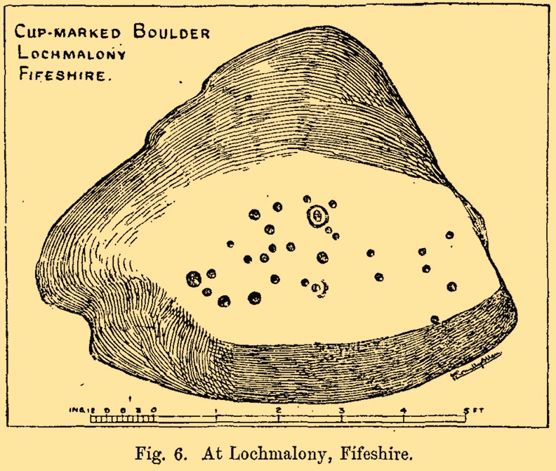
Cup-and-Ring Stone (destroyed): OS Grid Reference – NO 379 204
Archaeology & History
J.R. Allen’s 1882 sketch
Here’s another old carving that has succumbed to the lack of animistic respect endemic in modern culture. Ronald Morris (1981) reported that this carved rounded boulder was “dynamited by the farmer and (is) now no longer extant.” First described in 1882 and later included in the Fife Inventory (1935), the large smooth rock used to lay within a nice copse of dense gorse, measuring 2½m x 1¾m across and about 1m high from ground level.
It was uncovered in 1872 and mentioned briefly for the first time in Arthur Mitchell’s (1874) fine essay on the antiquities of Cromar, where he told that “Dr. Batty Tuke tells me there is a cup stone on a moor forming part of Lochmalonie farm, in the parish of Logie, Fifeshire.” His notes were followed up by the great Romilly Allen (1882), whose sketch is all that remains of this ancient site. The carving was subsequently included in one of Ron Morris’s (1981) survey of Scottish petroglyphs, describing it simply as,
“2 cups-and-one-complete ring (one mostly weathered off), diameters 10cm (4in) and 27 cups (carving depth and angle of slope not now known.”
Its isolation from any other known petroglyphs is a little odd and there is every possibility is accompanied a prehistoric burial of some sort; although from the attitude of the farmer, all trace of that would have gone too. On a more positive note, when Batty Tuke spoke with Romilly Allen about this carving, he told that he has “frequently noticed well-marked cups on dry stone dykes in the Glenduckie area.” Petroglyph explorers amongst you might want to spend some time meandering in this neck o’ the woods….
Morris, Ronald W.B., “Fife: Loch Maloney – Cup Marks,” in Discovery & Excavation, Scotland, 1967.
Morris, Ronald W.B., The Prehistoric Rock Art of Southern Scotland, BAR: Oxford 1981.
Royal Commission on Ancient & Historical Monuments, Scotland, Eleventh Report with Inventory of Monuments and Constructions in the Counties of Fife, Kinross and Clackmannan, HMSO: Edinburgh 1935.


")