Follow the same directions to reach the Big Rock carving. From here walk less than 100 yards up the slope, veering to your left and where you reach the rushes (Juncus grasses), walk up and keep your eyes peeled for the singular upright rock. Or as ‘Redkiteyorks’ said, go “up the slope 82.4 metres, 54.5 degrees(True) from IAG108 (Big Rock).” It aint hard to find really…
Archaeology & History
Another stone mainly for the purists amongst you. Little has been written on this possible carving. Boughey & Vickerman (2003) said simply:
“Large rough rock. Two possible cups on top and one further possible cup on W vertical face. Doubtful”.
References:
Boughey, K.J.S. & Vickerman, E.A., Prehistoric Rock Art of the West Riding, WYAS: Leeds 2003.
Hedges, John (ed.), The Carved Rocks of Rombald’s Moor, WYMCC: Wakefield 1986.
Sonning Cursus & other ancient remains (after Ford 1987)
Barely visible nowadays, the site was described by archaeologist Steve Ford (1987) as, “a very convincing cropmark with markedly rectangular end with entrance gap” at its far eastern end. This once impressive looking cursus aligns east-west and is found amidst a cluster of other neolithic and Bronze Age monuments.
It was first discovered by aerial surveying in 1959, but still remains unexcavated (I think!). The dead straight neolithic monument,
“consists of parallel ditches 45 metres apart extending for at least 200m west towards lower ground. The eastern end has a (flattened) terminal with a single entrance, whereas the western end is untraceable beyond a modern field boundary.”
In Roy Loveday’s (2006) survey, this cursus was stated as measuring 250m in length and 35m across. Although the western end hasn’t been located, it’s highly probable that it reached to the River Thames a short distance away. An excavation at one of the three ‘enclosures’ beyond the eastern end of this monument, revealed it have been built in the late neolithic period.
References:
Ford, Steve, East Berkshire Archaeological Survey, Berkshire County Council 1987.
Loveday, Roy, Inscribed across the Landscape, Tempus: Stroud 2006.
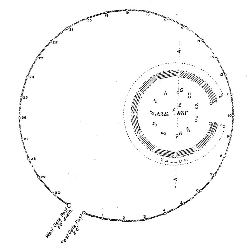
Bleasdale Ring & enclosure plan (Syd Wilson, 1900)
Pretty easy to find, and a nice walk to boot! Head up to Bleasdale Church (worth a look in itself!), keep going up the path north to the aptly named Vicarage Farm. From here you’ll notice a small copse of trees on your left (east) heading to the hills. To those of you who like Predator, “it’s up there – in them trees…!”
Archaeology & History
On my first visit here in the company of John Dixon and other TNA regulars, my first impression was “this is a henge” – and noted subsequently that it’s been described as such by several writers. But the general category given to this fascinating place is a ‘timber circle.’
Bleasdale ‘henge’ circle
First discovered at the end of the 19th century and described in considerable detail by Mr Dawkins (1900), this is a gorgeous-looking monument was erected in at once a gentle and tranquil, aswell as an imposing natural setting, at the foot of Fair Snape Fell (to the northwest) and Bleasdale Fell (due southwest). These aspects of the landscape would have had obvious mythic importance to the people who built this ring amongst the trees. A condensed version of Dawkin’s material was described in J. Holden’s (1980) Story of Preston, that outlined this circle as being,
“a centre for religious worship in about 1700 BC. It was made up of a circle of timber posts which enclosed an area 45 metres in diameter. In the centre was a small mound surrounded by a ring of oak posts and a circular ditch. Inside the mound there was a grave that had in it two pottery urns filled with human bones and ashes. Examination of the contents of these urns shows that the bodies were wrapped in linen and burnt on a funeral pyre. A small ‘accessory’ cup was found inside one of the urns and this may have contained food or drink for the afterlife.”
Urns from Bleasdale Ring1898 photo of Shadrach Jackson (left) & Tom Kelsall (centre) digging the site
Located within a much larger circular enclosure, the internal Bleasdale ‘henge’ Ring consisted of a small circle of eleven timber posts near the edge of the ditch, and an entrance way to the east, to or from which was an avenue of further wooded posts that led to the edge of the larger enclosure. It gives the impression that this was some sort of avenue along which a ceremonial procession may have took place, strongly suggesting a ritual function. Robert Middleton (1996) told that,
“The post circle and barrow appear to respect each other (in date), whilst the enclosure may be later. The post circle has been dated to around 2200 BC, although the context and reliability of this date is unclear.”
Looking out eastwards from the middle of the internal henge-style ring and through the ‘entrance’ we find an alignment with a large notch on the skyline which, modern folklore ascribes, is where the midwinter sun rises — which is very believable, but I aint seen it proven anywhere yet.
A much greater and full excavation report of this site was written by Raymond Varley (2010), whose essay I urge fellow antiquarians to read.
References:
Dawkins, W.B., ‘On the Exploration of Prehistoric Sepulchral Remains of the Bronze Age at Bleasdale,’ in Transactions of the Lancashire & Cheshire Antiquarian Society, volume 18, 1900.
Dixon, John, Journeys through Brigantia – volume 8: Forest of Bowland, Aussteiger Publications: Barnoldswick 1992.
Edwards, Ben, “The History of Archaeology in Lancashire”, in Newman, 1996.
Gibson, Alex, Stonehenge and Timber Circles, Tempus: Stroud 1998.
Holden, Jennifer (ed.), The Story of Preston, Harris Museum: Preston n.d. (c.1980)
Middleton, Robert, “The Neolithic and Bronze Age,” in Newman, 1996.
Newman, Richard (ed.), The Archaeology of Lancashire, Lancaster University 1996.
Sever, Linda (ed.), Lancashire’s Sacred Landscape, History Press: Stroud 2010.
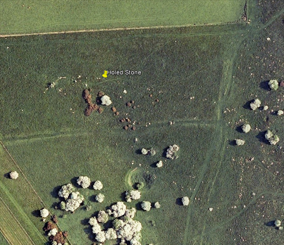
Follow the same directions as if you’re visiting the Polisher Stone at the top-end of Overton Down where it meets Fyfield Down. From here, walk down the slope for a hundred yards or so where you’ll notice, just above the long grassy level, a line of ancient walling running nearly east to west. It’s very close to the yellow marker in the attached aerial image shot to the right. If you walk along this line of walling you’ll find what you’re looking for.
Archaeology & History
Overton’s Holed Stone
As I’ve only been here once, and briefly — under the guidance of the Avebury expert Pete Glastonbury — my bearings on this site may need revising. There are two distinct sections of walling here: one has been excavated by Peter Fowler and his team; the other hasn’t. (correct me if I’m wrong Pete) And in Fowler’s (2000) fine survey of this area he does not describe this very distinct holed-stone in the line of walling, or adjacent “linear ditch F4”, as it was called. But then, many archaeologists don’t tend to find items such as these of any interest (unless their education stretches to other arenas, which isn’t usually the case). But the stone seems to be in a section of walling that isn’t in their survey; standing out in aerial imagery as a less well-defined, but still obvious line of walling that is closer to the fence, 70-80 yards north, with a decidedly Iron-Age look about it!
But, precision aside! — as you can see in the photos, the holed stone here isn’t very tall — less than 2 feet high; though we don’t know how deep the stone is set into the ground. This spot is on my “must visit again” list for the next time we’re down here!
There’s nowt specific to this stone, nor line of walling, nor settlement (as far as I know), but it seems right to mention the fact that in British and European folklore and peasant traditions, that holed stones just like the one found here have always been imbued with aspects of fertility — for obvious reasons. Others like this have also acquired portentous abilities; whilst others have become places where deeds and bonds were struck, with the stone playing ‘witness’ to promises made.
References:
Fowler, Peter, Landscape Plotted and Pierced: Landscape History and Local Archaeology in Fyfield and Overton, Wiltshire, Society of Antiquaries: London 2000.
Near the western end of the Middle Ridge, south of Dryas Dike, it’s probably best reached following the same directions to find carving no.435, walking past it but then following the footpath down onto the moor 100 yards further down the slope. Walk along here for about 200 yards till you get to the boundary stone. You’re close!
Archaeology & History
Sketch of carving 446Smiley Stone carving
First described by Stuart Feather and described by him in 1966, this small rounded stone comprises of nine or ten cup-markings with a long, enclosing line that circuitously goes around four or five of them. It’s a curious-looking design which, from one angle, gives the impression of a smiley face — hence the name (this is Boughey & Vickerman’s name for it — not mine!).
References:
Boughey, Keith & Vickerman, E.A., Prehistoric Rock Art of the West Riding, WYAS 2003.
Feather, Stuart, ‘Mid-Wharfedale Cup-and-Ring Markings – no.43 and 44: Middleton Moor, Ilkley,’ in Cartwright Hall Archaeology Group Bulletin, 11:4, 1966.
Just below Black Hill in the Middleton Moor Enclosure, little more than 10 yards east of the footpath on the east side of Loftshaw Gill, the slope drops down and into a slight ‘bowl’ in the landscape. Here it is!
Archaeology & History
This is a previously undiscovered prehistoric settlement, enclosure, or something along those lines! We came across it in April 2005 and is found amidst the mixed heather and bracken and has a scattering of small stones, as if in the wake of a dried stream from bygone times. But whatever stream might once have been here, it’s long since fallen back to Earth — but at a point where a few rushes (Juncus conglomeratus) can be seen we find the aged remains of a large oval enclosure.
Similar in form to the other remains located up here by Eric Cowling (1946) in the 1930s and ’40s, when Richard Stroud and I first found this, structural remains of distinct lengths of walling were visible – but once the vegetation started growing back here again, it was almost impossible to discern.
Faint remains of enclosure walling
The main archaeological remains comprises of an oval-shaped structure, with what seemed liked a distinct Bronze Age note stamped on the walling — though it could be earlier, but without excavation it’s impossible to say. Most of the walling was just above ground-level, making it difficult to appreciate in the photo. It measures approximately 40 feet north-south and 33 feet east-west. The walling itself averages between 18-24 inches wide and was no more than one-foot tall at the highest. Near the middle of the enclosure there were further sections of walling indicating different ‘rooms’ in the overall structure of things here.
Like I say, we unfortunately couldn’t get a decent image of this site cos the vegetation was already covering it up. So if you wanna see it, gerrup there soon after the heather burning’s been done here — otherwise it’s gonna be at least another year before you getta chance to see anything. In Richard Stroud’s photo here, you’re looking at the bottom curve of the enclosure. You can just make out the line of walling near the centre of the picture, and two-thirds the way to the right you can see the enclosure wall curve closer to the bottom of the photo. (the site obviously requires a much better assessment from someone far more competent than me!)
References:
Cowling, E.T., Rombald’s Way, William Walker: Otley 1946.
From the little hamlet of Langbar, head up to the steep footpath to Beamsley Beacon and from there along the footpath get yourself between the giant cairn known as The Old Pike and Round Hill. About halfway between these two points the moor levels out (with brilliant views in all directions) and 200 yards southeast of the upright boundary stone, this well-defined carved rock is just a few yards north off the footpath. It seems to be just over the boundary line of Middleton Moor and onto the Beamsley Moor side (not that you give a shit when you’re up here ambling about – but the cartographers like to get things right I s’ppose!).
Archaeology & History
…and from another angleSketch of the design
Near the very top of the moor this one — this is a small carving that I rediscovered in March 2005, much of it covered in peat and heather. It’s very similar to some of the central designs found on the Baildon Moor cup-and-ring carvings, with four cup-markings (3 are deep) in a slight arc to the southern edge of this small, squared stone, very much like carvings 126 and 130 in the Boughey & Vickerman (2003) survey. However, unlike the Baildon Moor examples, no burials seem to accompany this carving—although the surrounding heather may be hiding other archaeological remains.
References:
Boughey, Keith & Vickerman, E.A., Prehistoric Rock Art of the West Riding, WYAS 2003.
Follow the same directions to reach the Middleton Moor carvings, numbers 436 and 437, up along the footpath. This is the easiest to find as it’s right beside the footpath – as Richard Stroud’s photograph clearly shows.
Archaeology & History
Drawing of CR-435Middleton Moor CR-435
Near a cluster of other cup-and-ring marked rocks, this decent example can be found besides what may be a prehistoric trackway running roughly east-west over the Long Ridge to Foldshaw Ridge. Amazingly, this stone was never previously catalogued until Boughey & Vickerman’s survey in 2003. Just goes to show what y’ can find if y’ gerrof yer arses and look for yerselves! Comprising at least thirty cups and several lines, one faint cup-and-ring is discernible on the western edge of the stone.
If you walk westwards, back up to the hilltop from here (only a couple of hundred yards), a single upright stone which some might consider megalithic, stands right before your eyes! An excellent spot!
References:
Boughey, Keith & Vickerman, E.A., Prehistoric Rock Art of the West Riding, WYAS 2003.
Follow the same directions to get to the Middleton Moor Carving 437, along the Ridge Way footpath, and this stone is just a few yards away.
Archaeology & History
This all-but insignificant carving was first described in Boughey & Vickerman’s (2003) survey, as a “small rough grit rock sloping into turf” with what may be two faint cup-markings etched on its surface. Unless you’re a bittova rock-art fanatic, this might not be of much interest to you! (thanks to Richard Stroud for use of his photo!)
References:
Boughey, Keith & Vickerman, E.A., Prehistoric Rock Art of the West Riding, WYAS 2003.
Head for the gorgeous little hamlet of Langbar, a few miles northwest of Ilkley. Less than ½-mile before the village, keep your eyes out for the footpath bearing east onto the moors at Moor End Farm (right-hand side of road if you’ve travelled from Ilkley). Walk along the Long Ridge footpath to where the fields on your left finish and the moorland proper opens up. Hereabouts, check the stones in the heather to your right! If you amble about looking, you’ll find it!
Archaeology & History
Crap drawing of CR-437
This is another one of those carvings for the purists amongst you. Less than ten yards off the footpath on Long Ridge is this medium-sized rock with several cup-marks, and lines, on both its top and vertical faces. Boughey & Vickerman (2003) think there to be at least five cups on the top, with perhaps nine on the vertical east face, though some of these are debatable. (the drawing I’ve done is from their book)
References:
Boughey, Keith & Vickerman, E.A., Prehistoric Rock Art of the West Riding, WYAS 2003.