From Steeton go to the top of Mill Lane, turning left up High Street. After about 200 yards, turn right (opposite Falcon Cliff street) and go down past the end of the row of terrace houses, to the end of the dirt-track past the allotments. Then cut up the fields to the rocky crags a coupla hundred yards above you on the left. Over the wall at the top, look out for the single tree in the field by the walling where there’s a small cluster of stones. That’s it!
Archaeology & History
The little Crater Stone and its more ornate companion, below
Hiding away on private land, this lovely simple carving was first located on Wednesday, April 7, 2010 (in the fine company of the Great Guru). Our initial assessment found it to be just a simple cup-marked stone with 4 normal cup-marks, plus two large ‘bowls’ just where the rock goes into the ground. When we found it the other day, Steve pulled a little bit of the earth back to get a better look at the stone, but we need to return here to unearth the rest of the stone (we didn’t have utensils with us this day, as we were just playing out).
The position of the stone in the land is excellent for views, looking down on the greater-looking Dragon Stone carving just a few yards away, but also looks across the Aire Valley and onto the moorland heights above Rivock, and the south-side of Ilkley Moor. I’ll update and add further notes and clearer images when we go back to the site (hopefully) in the next week (aswell as hopefully conjure up a more respectable title!).
Take the road up across from Ilkley train station uphill towards the moor until you reach great rocks on your right. From here, the Cow & Calf Stones car park (packed with tourists and litter everywhere these days), go up the steep footpath onto the moor. As you level out looking across the first moorland ridge, to your left is a rounded hillock. Go into the heather there and near its small peak and you’ll find what you’re looking for.
Archaeology & History
This is a nice big stone, found amidst a clump of other stones, that gives the distinct impression of once being a large cairn or similar artificial prehistoric feature. But that’s wishful thinking on my behalf… This long fat 10-foot long rock has the distinct signature of someone who thought it a good idea to carve his little name on the carving in 1978, as the name of the rock tells: “Wray Nov 78” — vandalism which the local Ilkley Parish Council and local businessman Tom Lonsdale validate as little more than “twenty-first century informal unauthorised carving.” Beneath the great artist’s signature we find two distinct cup-marks above a large rounded bowl, inside of which seems to be the impression of an old ring, but this seems due to the actions of water and lichen. There are perhaps another two faded cup-markings alongside those distinctly visible. In Hedges (1986) survey he described the “top flat surface has three cups and one basin” — so let’s play safe and go with that!
Close-up of cups, bowl & modern etching
It’s a good stone, sat upon a fine ridge with distinctive views for miles both east and west along the valley of the Wharfe, and north to the ancient settlements and burial grounds of Middleton Moor on the other side of the River Wharfe. From here, behind and up onto Ilkley Moor, unfolds its greater mythic history, scattered and hidden over differing ages. In years past, this site was a fine one for reflection and insight. Today, one must venture further and to other sites for such quiet realities. Close by you can find the double-ringed carving of stone 318 and other faded cup-mark stones nearby.
References:
Boughey, Keith & Vickerman, E.A., Prehistoric Rock Art of the West Riding, WYAS: Wakefield 2003.
Cowling, E.T., Rombald’s Way: A Prehistory of Mid-Wharfedale, William Walker: Otley 1946.
Hedges, John (ed.), The Carved Rocks on Rombalds Moor, WYMCC: Wakefield 1986.
From Silsden go up the long hill (A6034) towards Addingham until the hill levels out, then turn left on Cringles Lane (keep your eyes peeled!) for a half-mile where you need to veer right along Banks Lane and go 100 yards past Moorcock Farm Hall where the footpath takes you into the fields on your right. Walk down the line of the wallings, thru the gate, and keep following down until you reach a cluster of large rocks. Stop here and look over the wall where you’ll see one of the boulders poking its head out on the other side. That’s it!
Archaeology & History
First discovered by Eric Cowling in the late 1930s during one of his explorations of the immense Counter Hill earthworks (thought to be Iron Age), whose remains can still be seen encircling the peaked hill close by. The stone is found in the edge of the walling halfway down the field towards the Marchup enclosure and is just inside the outer edge of the Counter Hill ditched enclosure surrounding the hill above you. (on the other side of the wall from the carving, you can make out the remains of the faint line of the ditch running pretty straight up towards the next wall)
Cluster of cups by wallingCounter Hill carving from above
At the top eastern edge of the stone is a clear cluster of 3 cup-markings, just as the rock meets the walling. A much more faint group is visible to the left. Cowling (1946) suggesting that the three-cup-cluster “shows the final form of the fylfot symbol,” i.e., the three-armed swastika. Boughey & Vickerman (2003) meanwhile suggest that one of the two clusters are “doubtful (possibly recent?).”
When we came to this site yesterday, the day was overcast and cloudy. But it seemed there may be more to this carving than has previously been recorded. What may be a faint ring seemed possible near the middle of the stone, with a natural crack running through it (you can just about make it out in the photo on the right). There also seemed to be other faint lines on the rock, but until we’ve been here again with better lighting conditions, the two groups of 3-cups is the symbolic state of play for this stone!
References:
Boughey, Keith & Vickerman, E.A., Prehistoric Rock Art of the West Riding, WYAS: Wakefield 2003.
Cowling, E.T., Rombald’s Way: A Prehistory of Mid-Wharfedale, William Walker: Otley 1946.
Hedges, John (ed.), The Carved Rocks on Rombalds Moor, WYMCC: Wakefield 1986.
Follow the same directions to reach the Harden Moor circle. From here, walk down the footpath at its side down the slope for 100 yards and take the first little footpath on your left for 25 yards, then left again for 25 yards, watching for a small footpath on your right. Walk on here for another 100 yards or so, keeping your eyes peeled for the image in the photo just off-path on your left, almost overgrown with heather.
Archaeology & History
This is just one of several cairns in and around this area (I’ll probably add more and give ’em their own titles and profiles as time goes by), but it’s in a pretty good state of preservation. Nothing specific has previously been written about it, though it seems to have been recorded and given the National Monument number of 31489, with the comment “Cairn 330m north of Woodhead, Harden Moor.” (anyone able to confirm or correct this for me?)
It’s a good, seemingly undisturbed tomb, very overgrown on its north and eastern sides. Three pretty large upright stones, a couple of feet high, remain in position with an infill of smaller stones and overgrowth (apart from removing a little vegetation from the edges to see it clearer, we didn’t try disturbing it when we found it). It gives the impression of being a tomb for just one, perhaps two people and is more structured than the simple pile-of-stone cairns on the moors north of here above Ilkley and Bingley. Indeed, the upright stones initially gave the impression of it once being a small cromlech of sorts! Other cairns exist close by, but until we get heather-burning done up here, they’re difficult to find – or at least get any decent images of them!
Not too far from the High Laithe cup-and-ring stone. Along the A6131 out of Skipton, park up at the Rendezvous hotel and go up the road on your left, over the canal. As you approach the second house up, note the rock on the right-hand side of the tiny road, perched on the edge above the stream, with ivy creeping up one side of it. That’s it!
Archaeology & History
This stone was moved to its present position a few decades back, sometime before Hedges (1986) first recorded it in his Carved Rocks work. It’s a reasonably large boulder, resting on the slope above the drop to the stream below, and will probably drop into the waters in the not-too-distant future. Whether the stream had any initial relationship with the cup-markings etched on its surface, we’ll probably never know (a number of rock art students love the water-stone relationship — and this one is no doubt in their listings!). Its first literary appearance by Hedges described it thus:
“Large fairly smooth grit rock sloping down to stream at E and into ground and grass at W. Eleven cups, circle of nine very small cups at one end, groove from depression, one other groove and possible cup.”
Lower half of CR-016
Which just about does it justice. When we visited the place yesterday, the cluster of small cups at the top of the rock were difficult to see clearly in the grey daylight; but what seems to be another 2 cups (not in Hedges, nor Boughey & Vickerman’s [1986] survey) may be on the lower-half of the stone, and can be seen in the photo here. We need to go back again on a bright day and catch the stone in a different mood to suss out whether we were just seeing things.
References:
Boughey, Keith & Vickerman, E.A., Prehistoric Rock Art of the West Riding, WYAS: Leeds 2003.
Hedges, John (ed.), The Carved Rocks on Rombald’s Moor, WYMCC: Wakefield 1986.
Worth the short trek if you like your cup&rings! On the Aire Valley Keighley-to-Skipton road (A629), as you approach the southern outskirts of Skipton, take the turning at the roundabout as if you’re going into the town up the A6131. Go over the next roundabout a coupla hundred yards on, then 200 yards further on note the right-turn up over the canal (big hotel just here, where you could park up). Walk over the canal up the tiny country lane. Ignore the first left turn and walk up, bearing next left uphill and onto the footpath. Walk up the hillocky quarried bit until you reach the stile in the wall. Once on the other side, look in the walling 20 yards uphill. You can’t miss it!
Archaeology & History
First described by Messrs Hartley and Radley in the Yorkshire Archaeological Register of 1968, this small “standing stone”, less than three-feet tall, has a distinct cup-and-double- ring carved onto its upright north-facing edge. The outline of the carving is visible even in bad light, though you might wanna rest and gaze for a minute or two for yourself and the lighting to adjust if it’s a grey day. There’s another cup-marking below the bottom right of the double-ring, with another ‘possible’ just above ground-level.
References:
Boughey, Keith & Vickerman, E.A., Prehistoric Rock Art of the West Riding, WYAS: Leeds 2003.
Hedges, John (ed.), The Carved Rocks on Rombald’s Moor, WYMCC: Wakefield 1986.
There is very little known of this once proud standing stone, said by one writer to have been about 12 feet long: six-feet of it in the ground and the other six-feet above ground. A decent monolith by anyone’s standard! But some dickheads forty years or more ago thought it a good idea to destroy the site, or as it was diplomatically put, “was removed in advance of road widening.” Vandalism no less – though it’s demise was recorded by the Department of the Environment “on behalf of the Inspectorate of Ancient Monuments.” (DES, 1973)
A local journalist called Andrew McCallum described the site in his unpublished manuscript on the history of the parish of Mansewood, telling it to be near Cowglen:
“near Boydstone Road, midway between Kennishead and Barrhead Road. 6 feet above the ground, and at least as many below. Age and purpose are unknown.”
Some thirty years later, Miss Adamson (1973) told us that,
“The straight-sided block had its base set on yellow sandstone. Immediately above the bedrock small stones and earth had been packed against the W and N faces of the standing stone. On top of the packing were two boulders set at right angles to wedge the sides of the stone. No burials or cremations were found.”
Though on this latter remark we have to consider the possibility that the standing stone may once have accompanied a burial, as the nearby place-name ‘Carnwadric’ indicates a cairn, or burial site. A field-name survey of the immediate region may prove valuable.
References:
Adamson, H., “Glasgow: Boydstone Road – Standing Stone,” in Discovery & Excavation in Scotland, 1973.
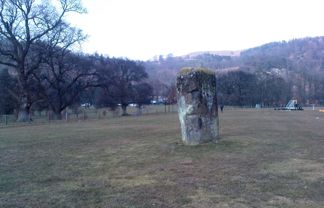
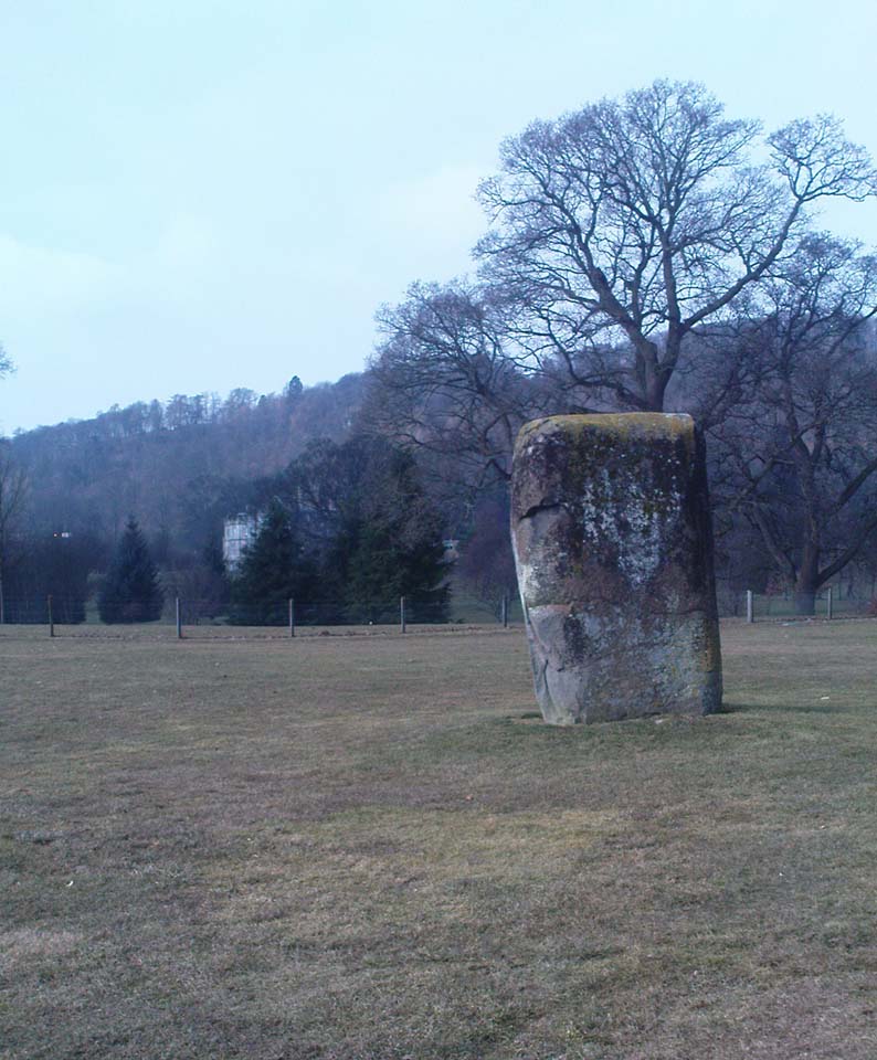
Dead easy to find! From Stirling head out on the A9 road towards Bridge of Allan and Stirling Uni. You’ll hit a small roundabout a mile out of Stirling – go straight across and up the little bendy road. Follow this round the bottom side of the Uni for a half-mile, watching out for the left-turn as the tree-line ends, taking you up to the factory behind the trees (if you hit the roundabout a bit further on, you’ve gone too far!). Go up the slope and onto the level sports playing fields – where this old beauty will catch your eye! If you somehow miss it, just get to the Uni and ask some of the students where it is!
Archaeology & History
Airthrey Stone, looking NW
This single standing stone is a beauty! It’s big – it’s hard – and it’s bound to get you going! (assuming you’re into megaliths that is) Standing proud and upright on the eastern fields of the Stirling University campus, A.F. Hutchinson (1893) measured it as being “9ft 1in in height. Its greatest breadth is 4ft 10in, and its circumference 14ft.” A bittova big lad! More than fifty years later when the Royal Commission (1963) lads got round to measuring its vital statistics, only an inch of the upright had been eaten by the ground. The stone was highlighted on the earliest OS-maps of the area.
Folklore
Of the potential folklore here, most pens and voices seem quiet; although Mr Hutchinson (1897) told of William Nimmo’s early thoughts, linking the history of this stone with the others nearby, saying:
“Of what events these stones are monuments can not with certainty be determined. In the ninth century, Kenneth II, assembled the Scottish army in the neighbourhood of Stirling, in order to avenge the death of Alpin his father, taken prisoner and murdered by the Picts. Before they had time to march from the place of rendezvous, they were attacked by the Picts… As the castle and town of Stirling were at that date in the hands of the Picts, the rendezvous of Kenneth’s army and the battle must have been on the north side of the river; and as every circumstance of that action leads us to conclude that it happened near the spot where these stones stand, we are strongly inclined to consider them as monuments of it. The conjecture, too, is further confirmed from a tract of ground in the neighbourhood which, from time immemorial, hath gone by the name of Cambuskenneth: that is, the field or creek of Kenneth.”
And although this hypothesis is somewhat improbable, it was reiterated in the new Statistical Account of 1845, which also suggested that this and the other Pathfoot Stone were “intended probably to commemorate some battle or event long since forgotten.”
References:
Hutchinson, A.F., “The Standing Stones of Stirling District,” in The Stirling Antiquary, volume 1, 1893.
Royal Commission on the Ancient & Historical Monuments Scotland, Stirling – volume 1, HMSO: Edinburgh 1963.
Pretty easy to find. Head down the B8051 road south, out of Stirling, for a ¼-mile. Keep your eyes peeled for the central police station on your right as you come out of town. The stones are on the grassy forecourt in front of the police station!
Archaeology & History
It’s amazing that these stones are still standing! Jut out of the city centre, very close to the main road and right outside the central police station: if these standing stones would have stood anywhere in England, they’d have been destroyed. Thankfully, the Scots have more about them regarding their history, traditions and antiquities.
Randolphfield stone SWNE Randolphfield stone
Of the two stones that remain here, they stand in (just about) the same position that they were shown as on an 1820 map of Stirling. The northernmost of the two is about 3½-feet tall and rests upright against the edge of the track and lawn; whilst its taller companion — knocking close on to six-feet tall — stands proudly near the middle of a well-kept lawn less than 50 yards away. Once you’ve found one, the other’s easy to spot!
It’s obvious that the larger of the two stones was cut down at some time in the recent past, as there are several blatant cuts where the standing stone had been snapped into at least three portions — but whoever did the damage was given a bittova bollocking, as the stone was cemented back into its near-original form and stood back upright again. To this day, as one of the female officers coming out of the station indignantly told me, “they’re protected!” Long may they stay that way!
In Mr A.F. Hutchinson’s (1893) early description of these stones he told that they stood “in a line from SW to NE — the line of direction making an angle of 235° with the magnetic north.
“The southwest stone stands 4ft above the ground. The portion underground measures 2ft 5in; so that in all it measures 6ft 5in. Its girth is 6ft 6in. It is four-sided in shape—nearly square—three of the faces measuring each 21 inches, and the fourth 15 inches. The northeast stone is smaller and less regular in form. Its height above ground is 3ft 6in, and its girth 4ft 6in. Both stones are pillars of dolerite, of the same material as the pillar stones of the Castle rock, from which place they have apparently been brought. The larger stones shows some marks on it, which have been supposed to be artificial. They are , however, merely the natural joints characteristic of these blocks…”
Folklore
Like many standing stones scattering our isles, this site possesses the old tradition of them marking a battle — in this case, the Battle of Bannockburn. Once again, Mr Hutchinson (1893) wrote:
“The local tradition as to the origin and meaning of these stones is well-known. It is thus stated by (William) Nimmo in his History of Stirlingshire, p.84…: ‘Two stones stand to this day in the field near Stirling, where Randolph, Earl of Murray, and Lord Clifford, the english general, had a sharp encounter, the evening before the great battle of Bannockburn.’ Again, p.193:- ‘To perpetuate the memory of this victory…two stones were reared up in that field and are still to be seen there.’ …The Old Statistical Account of St. Ninians (Rev. Mr Sheriff, 1796), makes the same statement, p.406-8:- ‘In a garden at Newhouse, two large stones still standing were erected in memory of the battle fought on the evening before the battle of Bannockburn, between Randolph and Clifford.'”
Yet the name ‘Randolphfield’ is apparently no older (in literary records) than the end of the 17th century and the thoughts of Hutchinson and other local historians is that the two stones here, whilst perhaps having some relevance to an encounter between the Scots and the invading english, were probably erected in more ancient times.
References:
Hutchinson, A.F., “The Standing Stones of Stirling District,” in The Stirling Antiquary, volume 1, 1893.
Royal Commission on the Ancient & Historical Monuments Scotland, Stirling – volume 1, HMSO: Edinburgh 1963.
Follow the same directions as those to reach the small Central Design Stone up past the top-end of Shipley Glen. You’ll notice the small disused quarry just a few yards away, and this partly-covered flat stone lies right at the very edge of the quarry itself.
Archaeology & History
Faint cups on CR-122Plan of CR-122 (after Hedges)
Unless you catch this stone in good light, many of the cups on this design are difficult to make out; but defocus for a bit and they’ll come to you. Around 13 cups have been counted on this stone, with a couple of grooves: one of which descends just by the small arc (a common local feature on Baildon’s carvings), near the eastern side of the stone. A larger basin below this, covered by earth, may or may not be natural. Two of the cups here may have been carved sometime in the late 19th or early 20th century, probably around the time the quarrying was being done.
As is common in some parts of Britain, this carving (and others nearby) was found in association with a small cairn-field, much of which has long since gone.
It’s very probable that there were other petroglyphs close to this one, but which have subsequently been destroyed as a result of the quarrying operations here.
References:
Baildon, W. Paley, Baildon and the Baildons – parts 1-15, Adelphi: London 1913-1926.
Bennett, Paul, Megalithic Ramblings between Ilkley and Baildon, private manuscript: Shipley 1982.
Boughey, Keith & Vickerman, E.A., Prehistoric Rock Art of the West Riding, WYAS: Leeds 2003.
Jackson, Sidney, “Cup-Marked Boulder near the Glovershaw Footpath,” in Cartwright Hall Archaeology Group Bulletin, 2:17, 1957.
Hedges, John, The Carved Rocks on Rombald’s Moor, WYMCC: Wakefield 1986.