From Askwith village go up the Moor Lane and at the crossroads go straight across (Snowden Moor is across left). Go down and along Snowden Carr Road until the road levels out and, watch carefully, about 500 yards on from the crossroads on your left you’ll see a small crag of rocks in the fields above. Stop and go through the gate walking up the field and as you near the top you’ll see a gate across to your left that leads onto the moor. Go through this and on the path which veers up to the right up to the Tree of Life Stone. About 20 yards along, keep your eyes peeled just off-path, to the left, where a small rounded stone hides at the edge.
Archaeology & History
This was one of a number of cup-markings that Graeme Chappell and I came across in the early 1990s, though it didn’t receive any literary attention until included in Boughey & Vickerman’s (2003) survey. It’s only a small fella, consisting of just six or seven cups on its upper rounded surface — though what may be a carved line runs round the southern side of the stone. It seems to have been associated with a small cairn close by (a common feature on these moors) and adjacent prehistoric settlement walling. In Boughey & Vickerman’s text, they gave the following notes:
“Small rock with rounded surface at ground level, near scattered cairn. Seven or eight cups, possible grooves at edge.”
Drawing of the stone (Boughey & Vickerman)
[You’ll notice in the photo above that the local phantom painter had been here again, artistically highlighting the cup-marks. The photos we took were done earlier this year, when the paint (or whatever it is) was first noted. It had not been painted-in the previous autumn. But most notably is the fact that this carved stone has never previously appeared on the internet (until today) and the only other reference to it is in the standard Boughey & Vickerman text. This would indicate that whoever it is that’s painting the carvings up and down mid-Wharfedale possesses a copy of that text, aswell as being relatively new to the subject of rock art.]
References:
Boughey, Keith & Vickerman, E.A., Prehistoric Rock Art of the West Riding, WYAS 2003.
Follow the same directions to reach the superb Badger Stone carving, and from here take the footpath that runs downhill. You’ll cross another footpath about 100 yards down the moor, but just keep walking down the path and you’ll notice the small copse of woods ahead of you. As the footpath begins to swerve roughly away, northeast, heading away from the said woodland, keep your eyes peeled on your left for a reasonably large but flattish rock close to the ground (in summer it’s surrounded by bracken) about 75 yards away. That’s your target!
Archaeology & History
Of the hundreds of cup-and-ring stones on Ilkley Moor and district, this is one of my personal favourites! I first visited the stone in 1977 as a young teenager and was mightily impressed by the unusual nature of the design here — and that impression still remains. Aswell as possessing the usual cups and rings, the Barmishaw Stone is one of just a few rocks also possessing a sort of ‘ladder’ design or linear pattern within the overall carving: an insignia echoed on the nearby Willie Hall Wood carving, the Piper Stone, and also on the Panorama Stones. As with the ‘ladders’ on the Panorama carving, those found here at Barmishaw are very eroded and are increasingly difficult to see during the daytime (the best time to notice them is usually around sunrise or sunset, and particularly when the rock itself is wet).
The carving has been described many times, albeit briefly, by a number of writers. In John Hedges (1986) fine survey he said the following:
“Medium sized flat-topped rock…fairly smooth grit, sloping slightly east to west, covered with carvings, some of which are very worn. Slanting sunshine needed to detect them. About twenty-four cups, at least nine with rings or incomplete rings, two with multiple grooves half round and continuing straight down, one of them incorporating ‘ladder.’ Five other ‘ladders’ – in a good light. Cups mostly deep and clear.” A few years later, Boughey & Vickerman (2003) echoed much of Mr Hedges description, though noted that of the 24 cups with their rings, one possessed a triple ring.
Alan Davies’ illustration
Like so many cup-and-ring stones, they have given rise to hosts of fascinating theories and ideas — one of which is based on mathematics and metrology. In the 1980s, Alan Davies (1983, 1988) surveyed the Barmishaw Stone — and other carvings on Ilkley Moor — to explore the possibility that the cups and rings were laid out according to a basic unit of measure, the Megalithic Inch (MI), as proposed by Alexander Thom some years earlier. Although Davies’ work showed that such a primary unit of measure wasn’t to be found universally, his research at the Barmishaw Stone indicated “significant evidence for quanta of…3 MI,” although this occurred “when the analysis is restricted to only ringed cups.” Despite this, Davies thought that the existence of the Megalithic Inch was evident in this and other carvings on the moors, stating that:
“The repeated emergence of the significance of ringed cups, and the fact that all putative quanta seem to bear a simple numeric relation to each other do not seem to be coincidental.”
Although it has to be said that the selectivity of data in Davies’ research is more indicative that the Megalithic Inches in the the carvings was due, neither to chance nor mathematics, but more that the implements used to carve the rocks and the size of the hands of the people doing the carvings was pretty uniform and so, as a result, would give an obvious window of numeric similarities that can easily be mistaken as a deliberate metrology. These simplistic factors need assessing. In modern trials that we’ve done carving cup-markings, we’ve found them to be of similar size to those carved in prehistoric times—as you’d expect.
Barmishaw Stone (after Hedges, 1986)Barmishaw stone (Cowling 1946)
The ladder motif central to this carving may have related to early religious and ritual events here. Across the world, indigenous cultures commonly relate the ‘ladder’ to be a symbol of ascension, both by shamans, mystics and during rites of passage. The symbol represents the journey of the soul to and from supernatural realms. To discount this possibility at the Barmishaw Stone would be shortsighted.
The carving was very probably painted when our neolithic ancestors gathered here, much as Australian aborigines still do to their carvings using lichens and other plant dyes, with the respective ladders and lines changing colour where movements between worlds or shifts of attendant spirit occurred. By virtue of the its very name, I consider this rock to have been considerably important; the “ghost” aspect to barmishaw being a typically misconstrued aspect of ‘spirit’.
Folklore
This excellent cup-and-ring marked stone probably derives its name from the old dialect words “barm i’ t’ shaw”, meaning “ghost in the wood” stone. Whatever guise the attendant spirit of this rock may have had has long since been forgotten; though spectral accounts from the beginning of the nineteenth century until modern times may give us clues. There have been several reports of green-coloured elemental creatures around the area between here and the White Wells sacred spring a short distance to the east. The most recent account, from 1987, took on the modern mythic form of a little green man from space, with attendant UFO to boot! The Barmishaw Hole nearby was a place where faerie-folk used to live. Excesses of geological faulting and water makes the magickal nature of this place particularly potent.
References:
Allen, J. Romilly, “The Prehistoric Rock Sculptures of Ilkley,” in Journal of the British Archaeological Association, volume 35, 1879.
Allen, J. Romilly, “Notice of Sculptured Rocks near Ilkley,” in Journal of the British Archaeological Association, volume 38, 1882.
Bennett, Paul, “Cup-and-Ring Art”, in Towards 2012, volume 4, pp.83-92, 1998.
Bennett, Paul, The Old Stones of Elmet, Capall Bann: Milverton 2001.
Boughey, Keith & Vickerman, E.A., Prehistoric Rock Art of the West Riding, WYAS: Wakefield 2003.
Cowling, E.T., ‘A Classification of West Yorkshire Cup and Ring Stones,’ in Yorkshire Archaeological Journal 1940.
Cowling, E.T., Rombald’s Way: A Prehistory of Mid-Wharfedale, William Walker: Otley 1946.
Davis, Alan, ‘The Metrology of Cup & Ring Carvings near Ilkley in Yorkshire,’ Science Journal 25, 1983.
Davies, Alan, ‘The Metrology of Cup and Ring Carvings,’ in Ruggles, C., Records in Stone, Cambridge University Press 1988.
Eliade, Mircea, Patterns in Comparative Religion, Sheed & Ward: London 1958.
Hedges, John (ed.), The Carved Rocks on Rombalds Moor, WYMCC: Wakefield 1986.
Wright, Joseph, The English Dialect Dictionary – volume 1, Henry Frowde: Oxford 1905.
Pretty easy to find this. Go up Glen Lochay for 3 miles or so, on the road past the brilliant Stag Cottage carvings for a couple of hundred yards where you’ll see an old run-down army-looking building and past that is a curious large wooden and wire construction. Go up the farm-track next to this, past Duncroisk Farm, taking the footpath through the gates that go up to the side and behind the farm. You’ll see a rounded grassy knoll ahead of you. Head straight for it!
Archaeology & Folklore
This carving would appear to have been described for the first time by Mr Cormack (1952) in his longer essay on the cross-marked stones nearby. He said briefly:
“On the top of a small rock-strewn knoll about 300 yards behind Duncroisk farmhouse is a recumbent boulder, at one corner of which is a group of five fairly deep cup-marks of 2- to 3-inch diameter.”
Little else has been said of the site and even Ron Morris (1981) only gave the carving a brief mention in his survey, saying in passing how “east of a prominent rocky knoll, on whose summit is a cup-marked boulder…”, as he journeyed further uphill to explore the fascinating Duncroisk 4 carving with its scant cup-marks, human figurine and other curious insignia. And although this carving is probably only worthwhile for the real fanatics amongst you, I like the place — sad fella that I am!
Cup-marked stone, looking southClose-up of cups
There are five very distinct cup-marks etched onto a small, almost triangular section of the rock, sat close to a couple of other larger stones on top of the grassy knoll overlooking the glen, not far from some iron age walling. The cups are etched onto the topmost (northern) section of the rock, which is defined by a natural crack running across the surface, almost splitting one part of the stone from the other. The five cups are in no discernible linear formation. A possible sixth cup-mark and extended line may have been started on the other side of the crack on the stone, but its execution was stopped for some reason. This is by no means certain though.
Of some note is the larger stone immediately adjacent on top of this knoll, which — as Paul Hornby pointed out — is encrusted full of small garnets all over its surface. This may or may not have some significance to the cup-marked stone here. According to Mr Hornby, the nearby cup-and-ring stone at Duncroisk Burn also has garnets in it.
Morris, Ronald W.B., The Prehistoric Rock Art of Southern Scotland, BAR 86: Oxford 1981.
Royal Commission on the Ancient & Historical Monuments of Scotland, Archaeological Sites and Monuments of Stirling District, Central Region, Society of Antiquaries of Scotland 1979.
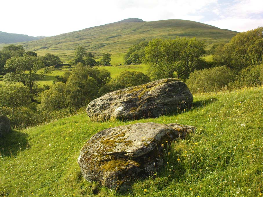
From Hebden Bridge, go up the Heptonstall road, going round the village and onto and through Slack, keeping straight on the road until it goes uphill for a short distance, then levels out; then watch out for the small right-turn and the single-track road heading to a dead-end. Go right to the end, the very end, and go through the gate and walk up the track onto the moor. As you reach the ridge and the moorlands north open-up before you, note the small ‘standing stone’ on your right, about 10 yards off-path. Go up past it, following the path up the small hill and keep going till you hit the triangulation pillar. From here, keep walking on the same path ESE for another 200 yards. Y’ can’t miss it!
Archaeology & History
The name of the place rather gives the game away a bit, yeah…? When I first moved to nearby Hebden Bridge in the 1990s, I noted the conspicuous place-name ‘Standing Stone Hill’ on the maps — so when I met local earth-mystery enthusiast John Billingsley and asked him about any remains up here, he said, with conviction, “there’s nowt up there!” (or words to that effect)
“Are y’ sure?” I asked. To which he repeated his dictum. But I wasn’t convinced of his words and, like any decent chap with energy for old stones and such things, wouldn’t take ‘no’ for an answer and went to check for myself – and wasn’t too surprised when I found this lovely looking standing stone — and a fine specimen of a monolith it is indeed!
Standing stone, looking southStanding Stone, looking east
Although not a tall specimen by any means, this rounded and weather-worn upright has fine character and age to it. Standing more than 3 feet in height and nearly as wide, the stone has a faded but distinct artistic carving of the letter ‘T’ on its western face (which you can make out on the photo, hopefully). It was thought this may have been an old boundary marking, but the stone aint on any boundary line so possibly relates to some local family who marked it with that deluded notion of ‘ownership’ of this part of the desolate moors.
It’s a beautiful spot up here, out on its own. I’ve sat here many times, both alone and with good heathen friends, gazing across the endless silence on days coloured with snows, mists, bright sunshine and heavy rains. It has that feeling of solitude, of being forgotten, of being truly untouched.
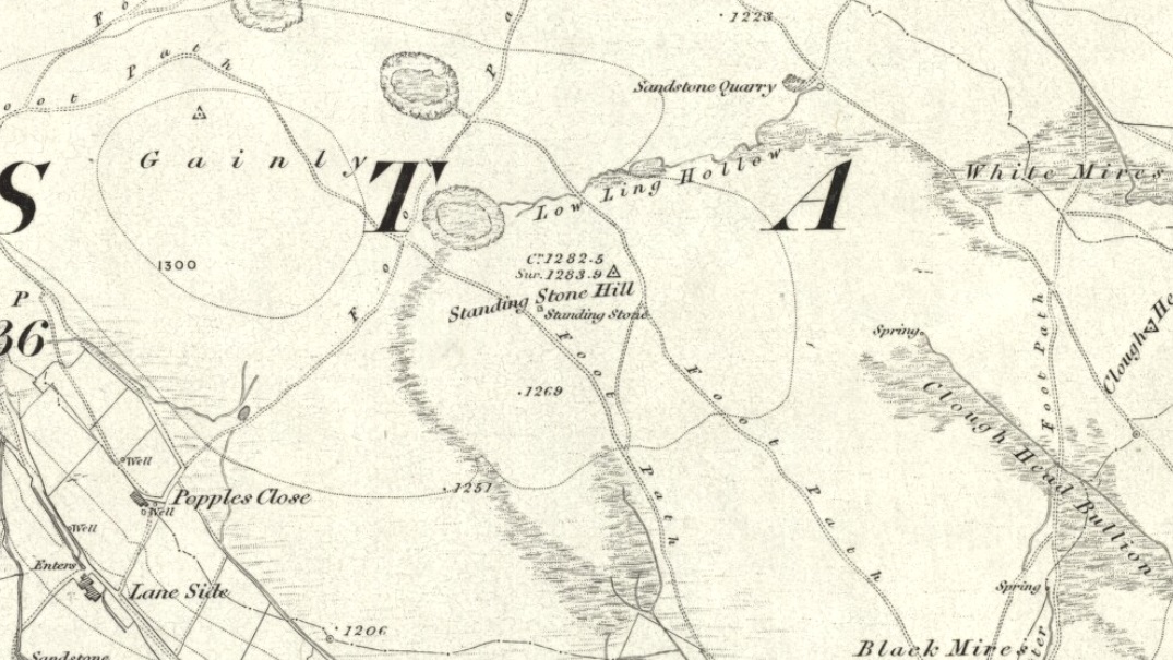
Standing Stone Hill on 1851 map
There are a couple of other possible standing stones on this section of moorland. One in particular appears to have been taller in bygone times and is marked on the 1851 OS-map of the region about 100 yards southwest of the triangulation pillar (you’ll notice it on your right, off-path, as you’re walking towards the pillar—shown at the position on the map here, right). Further west is the tall medieval Reaps Cross, where corpses were rested in their journey over the moors.
References:
Bennett, Paul, The Old Stones of Elmet, Capall Bann: Milverton 2001.
Tumulus (destroyed): OS Grid Reference – SK 961 052
Also Known as:
Wicheley Warren
Archaeology & History
This tomb and, it would seem, another 200 yards away, have long since been smashed up. The only decent reference to the site comes from Reginald Haines’ address to the Society of Antiquaries in January, 1903, where he told:
“In a quarry worked for freestone on Major Brathwaite’s land…was found in 1900 a skeleton, probably neolithic. The body was in a crouching position, with ‘the knees tucked under the chin,’ at a depth of about 3 feet. Unfortunately, no one interested in such things was at hand, and the remains were incontinently thrown aside and (are) presently buried under a mass of rubbish from the tunnels which were being worked for stone. Mr V.B. Crowther-Beynon was only able to recover a few teeth, though he seems to have found a few fragments of animal bones and bits of pottery at or near the spot.
“In December 1901, at a point about 200 yards from the last, where a fresh excavation was being made, a second interment was found. In this case the soil containing the remains came down in one block, and a few broken fragments of bone came to light, with a lower jaw. The jaw is now in Mr V.B. Crowther-Beyson’s possession, who communicated with Lord Avebury on the subject, sending the jaw, and received the following reply:
“‘to judge from your description (i.e., of the interment) it is certainly probable that the interment you mention belonged to the stone (neolithic) age. This, however, in the absence of weapons or implements, cannot be put higher than a probability. I think that lower jaws like very this might be found among our existing people, though I fear with hardly such good teeth. Their soundness and the way they were worn point strongly to a great antiquity.’
“Near the second interment occurred little patches of burnt soil of a conspicuously red colour. These may have been the sites of hearths.”
Mr Haines makes a final note about the scarcity of prehistoric remains found hereby, saying that “the only other relics of the stone age that claim notice here are an arrow-head of flint, picked up in a field near Market Overton in November 1990, by Mr Wing” — which is quite a distance away!
References:
Haines, “Prehistoric Graves at Wicheley Warren,” in Proceedings of the Society of Antiquaries, volume 19, no.2, 1903.
A couple of miles west of the Hutton Moor henge we find the faint remans of another large prehistoric ritual site, soon to fade from existence. Although the local farmer was aware of the existence of this ‘earth circle’ in his fields in the 1940s, the place wasn’t officially catalogued until Prof. J.K. St. Joseph noticed it following an aerial survey of the region in 1951 (from whence the aerial photo comes). Today sadly, much of the site has succumbed to the ravages of excessive agricultural activity and is all but destroyed. Faint traces of it can be seen at ground level when the crops are down, but most of it’s gone. Even when first discovered, the remains were sparse, as the photo (below) shows.
Early aerial photo of Nunwick hengeMr Dymond’s early ground- plan (from YAJ, 1963)
Neolithic in origin, the site was excavated in 1961 by D.P. Dymond who explored a portion of the bank and ditch and stripped a small internal section. His findings showed it to be structurally similar to the other henges in the area and of considerable size. Measuring 690 feet across, the henge spread across two fields and was bisected by a hedge and farm track. When Dymond first explored the henge he reported how the surrounding bank was between 1-3 feet high and had been spread to a width of 120 feet; the ditch was just a couple of feet deep; and the original ‘entrances’ north and south of the ring were still just visible as “slight depressions in the bank.”
The Nunwick henge was classed as a Class II henge (after Atkinson). Five feet smaller than the Thornborough (south) Henge, its entrances are close to north-south. The River Ure is less than half-a-mile from the site and the presence of other streams close by further emphasizes water as a potentially relevant ingredient. This element seems to have had some factor in the structure of the henge as there were many water-worn stones found in the embankment, which probably came from the nearby river. However, like many henges, very few remains were discovered upon excavation here, as Mr Dymond’s (1963) account tells:
“The 1961 Excavation was restricted to a single long section through the northwest side of the circle, to examine the structural details of the bank and ditch, and to confirm the apparent absence of an outer ditch.
“A small area, 22ft square, was stripped inside the ditch to test for pits or postholes, but nothing was found in the sandy silt which covers the gravel deposits. Air-photographs gave no indication of a former presence of standing features within the enclosure.
“The ditch was found to be 45ft wide and 5ft 10in deep, with a wide, shallow profile. Allowing for the destruction by ploughing of the upper edges of the ditch, the orignal dimensions of the ditch were undoubtedly greater. The edges of the ditch were not easy to see in excavation, as the fill was similar to the natural gravel subsoil and some slumping had occurred on the loose gravel faces. The ditch had apparently silted slowly with material washed in from both sides. At an early stage in the silting, when the accumulation was about 1ft, there had been occupation in a limited area, revealed by a circular patch of burnt material, 10ft in diameter, which contained many split pot-boilers reddened by fire.
“Between the ditch and bank there was originally a berm of 30ft. On the surface, this is not visible as the bank shades imperceptibly into the ditch. The bank was originally about 60ft wide, but is now considerably spread on both sides. In the 1961 section the bank survived only 18in high; this was sufficient, however, to show clear traces of tip-lines and the interleaving of loads. The lowest two inches of bank material consist partly of turf… Under the bank, the original turf-line was visible as a purple-black line, 1-3in thick, with traces of a weakly developed iron-pan. In the original composition on the bank there were many water-worn stones (3-9in across), now in the outer spread and in the bottom of the ditch; on the northern side of the circle where the bank is best preserved there are large quantities of these stones on the plough soil. Quarried from the bottom of the ditch, where the aggregate of the gravels was much larger, these stones were probably on the top of the bank.
“Two square were dug outside the bank, on the line of the section to text for an outer ditch. This confirmed the evidence of air-photographs that no such ditch existed. Of the six henges in the Ripon area, Nunwick is therefore the only one without two ditches.
“No dating evidence was found in the 1961 excavation. Three worked flints however, were picked up from the plough soil of the southwestern field near the henge. They consist of two waste flakes and a small flake scraper of opaque brown flint.”
Archaeologists and ley hunters alike have described how the Nunwick Henge aligns with the three prominent Thornborough Henges to the north. Significant…?
References:
Dymond, D.P., “The Henge Monument at Nunwick, near Ripon – 1961 Excavation,” in Yorkshire Archaeological Journal, part 161 (volume 41), 1963.
Wainwright, Geoffrey J., “A Review of Henge Monuments in the Light of Recent Research,” in Proceedings of the Prehistoric Society, volume 35, 1969.
Get yourself to the impressive multi-ringed Greystone Allotment carving, then walk to the copse of trees close by and bear left, following the edge of the fence along and following it when it turns down at right-angles, until you hit the bottom corner of the trees, where a path cuts in front of you. From the bottom corner of the trees walk 25-30 yards diagonally away from the trees. It’s under your nose somewhere damn close!
Archaeology & History
This is another archetypal cup-and-ring stone, similar in size and design to the recently discovered Slade (02) carving on Blubberhouses Moor, just over 4 miles (6.5 km) northwest (followers of Alexander Thom’s megalithic inch theory might be interested in assessing the measure of these two). It is one of number clustered in and around this small grass ‘moorland’ region, where a number of carvings perished in the 19th century. Thankfully this one survived. Boughey & Vickerman’s (2003) brief notes on the stone tell:
“Small, rough grit rough of regular oblong shape set very low in turf. Two cups, each with a ring, and connected by a groove.”
On a recent visit to see this carving, Danny Tiernan, Paul Hornby, James Elkington and I were unable to locate it. The carving may well have been destroyed, or moved. If anyone is aware of what has happened to this petroglyph, please let us know. We will be contacting the local authorities to see if any explanation is forthcoming from them.
References:
Boughey, Keith & Vickerman, E.A., Prehistoric Rock Art of the West Riding, West Yorkshire Archaeology Service 2003.
Park at Stump Cross Caverns on the B6265 road, then walk down the road for 200 yards till you reach the track on your left running over the fields in the direction towards Simon’s Seat. Walk on the track for about 600 yards until there’s a change of direction in the adjacent walling and then watch out for the dirt-track on your right, curving towards the small valley (if you hit the Skyreholme Wall carving (413), you’ve gone 100 yards past the turn-off). Go on here until you see the overgrown track on your left into a small disused quarry, and head right, down the grassy slope, checking out the few stones ion front of you 20 yards down. You’re damn close!
Archaeology & History
Carving no.404 (after Boughey & Vickerman)
A simplistic carving that was first described by fellow antiquarian Stuart Feather (1964), this is one of at least four cup-marked stones in a small group here, above the valley of Skyreholme Beck — better known at this part of the valley as the Troller’s Ghyll, haunt of various heathen lore. Although some of the carving has now been covered by the growing Earth, you can still see the majority of the design.
It is a flat, roughly triangular stone described by rock art students Boughey & Vickerman (2003) and having 13 cup-markings on it. To get a full look at the entire carving, you may have to roll a bit of the turf away from one side of the rock.
Folklore
Although we have no lore relating to this specific carving, the small valley over which this carving looks was long known as the abode of the legendary bharguests, or black dogs: underworld creatures of earlier heathen myths. Faerie lore can also be found a short distance further up the same stream.
References:
Boughey, Keith & Vickerman, E.A., Prehistoric Rock Art of the West Riding, WYAS: Wakefield 2003.
Same directions as the Slade 01 carving. But once you reach the upstanding stone cairn on the rocky hill, walk 220 yards (less than 200m) WSW and look around. You’re damn close! If you find the large cup-marked Slade 03 carving, walk back east about 10-20 yards and you can’t really miss it!
Archaeology & History
This is just one of at least seven previously undiscovered carvings on this section of moorland – and it’s worth looking for! The two other names we gave it — ‘owl’ and ‘sunset’ — come from the very notable design: owl thanks to it having the appearance of large owl-like eyes, and sunset as the two cup-and-rings are etched on the western edge of the rock and, when we found it yesterday, the sun was setting (albeit to the NW) and the image prompted talks of setting suns, the land of the Dead and other such worldwide indigenous religious myths (Harvey 2000) — for without recourse to such ingredients, these carvings are vacuous archaeocentric museum pieces and nothing more. And this carving at least deserves much more than mere cataloguing! The internationally renowned archaeologist, O.G.S. Crawford (1957) would have entered this carving into his ‘eye’ and ‘owl’ motif, representative of goddesses or spirit-forms, as would Gimbutas. (1989)
…and from above
But this carving is archetypal, as we can see, though would appear to have no other etched features on the stone’s surface. It is very close (if not within) the prehistoric graveyard that is plainly evident 30-40 yards south in the burnt heather and would very likely have had some mythic relationship with the dead (a symbiosis we have found in many cup-and-rings). We plan further ventures here in the coming weeks in the hope that we can unearth other prehistoric remains.
References:
Crawford, O.G.S., The Eye Goddess, Phoenix House: London 1957.
Gimbutas, Marija, The Language of the Goddess, Harper Collins: New York 1989.
Harvey, Graham (ed.), Indigenous Religions, Cassell: London 2000.
From Blubberhouses church by the crossroads, walk up the slope (south) as if you’re going to Askwith, for 100 yards or so, taking the track and footpath past the Manor House and onto the moor. Once you hit the moorland proper, take the footpath that bears left going down into heather and keep going till you hit the dead straight Roman Road path running west onto Blubberhouses Moor. Go on here for nearly a mile until you hit the stream and nearby Eagle Stone boulder. Walk upstream from here, on its eastern (right-hand) side for 100 yards, then walk up onto the level moor, scattered with rushes. Keep up here, heading towards the upright cairn open the skyline to the north. Once here, walk 80 yards (73m) WNW and you’ll note a number of flat stones embedded in the heather around you. You’re damn close!
Archaeology & History
Off-path and takes some finding and will all-but disappear when the heather grows back, so this one’s probably only for the purists amongst you. But I like it anyway! This is one of at least seven newly-discovered cup-marked stones hereby, including the nearby ‘Owl Stone’ with it’s big eyes! There are just two cup-marks on the flat surface: one an archetypal large cup 3 inches across and a half-inch deep; the other, a small faint cup less than 2 inches wide and very shallow which is easily missed if you pay little attention. On the photo here, the fainter cup is slightly above right of the centre. The carving appears to be on the far eastern edges of the Slade Cairnfield. Other undiscovered remains are likely to be found here.


")
")
")