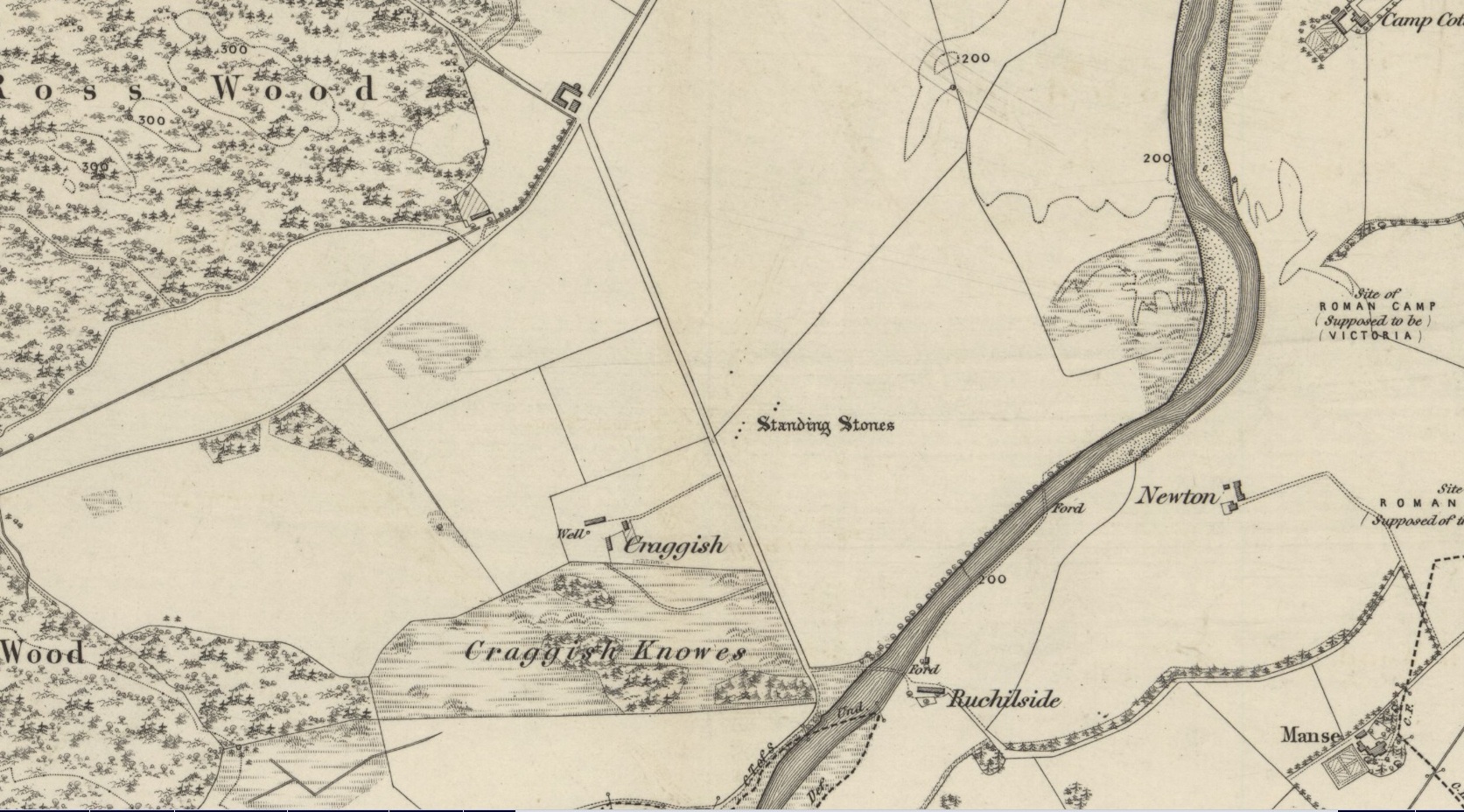
Standing Stones (destroyed): OS Grid Reference – NN 7643 2086
Archaeology & History
Site shown on 1886 OS-map
Highlighted on the 1866 OS-map was an impressive cluster of standing stones that sadly met their demise sometime around at the end of the 19th century. They were mentioned to “still exist” when the local writer Samuel Carment passed them in 1882, but had been destroyed by the time the Ordnance Survey lads resurveyed here in 1899. Altogether there were at least six of them, standing aligned sharply northeast-southwest and were described in one of Fred Coles’ (1911) essays, who lamented their passing. Listed in the stone row surveys by Burl (1993) and Thom (1990), the prime description we have of them was by Cole himself, who told:
“This site has also been wantonly bereft of its group of megaliths. Up to so recent a date as 1891 there were several. These were shown on the (Ordnance Survey map) as three in one line and two in another, on a field about one furlong NE of Craggish farmhouse, close to the road coming down from Ross, and nearly a quarter-mile NW of the ford across the Ruchil at Ruchilside.”
In Finlayson’s (2010) colourful survey of the local megaliths he told that the stones,
“Stood, by the road, in what is now ‘The Whinney Strip’: a boulder-strewn strip of land 20m wide dividing up otherwise flat and even grazing land.”
References:
Burl, Aubrey, From Carnac to Callanish, Yale University Press 1993.
Cole, Fred, “Report on Stone Circles Surveyed in Perthshire, Principally Strathearn,” in Proceedings of the Society of Antiquaries, Scotland, volume 45, 1911.
Thom, A., Thom, A.S. & Burl, Aubrey, Stone Rows and Standing Stones – 2 volumes, BAR: Oxford 1990.
Acknowledgments: Big thanks for use of the early edition OS-map in this site profile, Reproduced with the kind permission of the National Library of Scotland.
Get to the Cow & Calf Rocks, go up across the car-park as if you’re gonna go up onto the moor and walk up the steep footpath uphill to the left of the crags. Once you get level with the crags, take the footpath bending left and walk along here for 110 yards, keeping your eyes peeled for the low smooth rock on the right of the footpath, just where another path meets it. You’ll find it.
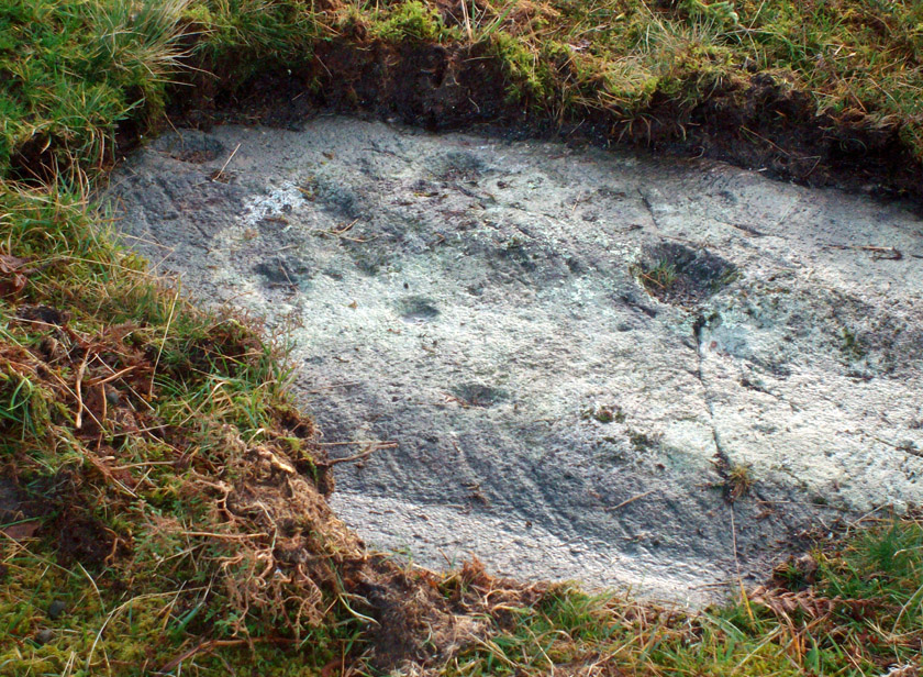
Archaeology & History
Close-up, from above
This quiet little stone has seen better days. Nearly destroyed a few weeks ago when the Emmerdale Farm film-crew churned up sections of the moor right over the side of this carving—but thankfully it still remains intact (you or I would have been prosecuted for such damage).* The carving is a simple one in graphic terms, comprising simply of three cup-markings, all on the southern side of the rock. Close to several other petroglyphs (the Wray Stone is 78 yards north and several other more ornate carvings are close by), the carving was first described in the Hedges (1986) survey as a “small, low smooth grit rock sloping slightly NW to SE in crowberry, bilberry, grass and bracken. Three clear cups.” But it has to be said, one of them is fading fast. Let’s hope this humble little carving doesn’t fall prey to those who are gradually turning our moorlands into a park.
References:
Boughey, Keith & Vickerman, E.A., Prehistoric Rock Art of the West Riding, WYAS: Leeds 2003.
Hedges, John, The Carved Rocks on Rombald’s Moor, WYMCC: Wakefield 1986.
* As the footpaths on Ilkley Moor continue to be widened and paved by those who reckon they like these moors, it’s obvious that more prehistoric sites up here are going to get damaged. It’s difficult to see what the local archaeologist or Natural England are doing to ensure that these environmentally-damaging schemes don’t encroach on the mass of rich prehistoric sites on the moors, most of which have never been adequately assessed (the philosophy of “if we don’t know it’s there, it doesn’t matter if we destroy it” seems evident in some of those working for the local council). Before any work or structures are dug on Ilkley Moor, an archaeological assessment is, I believe, supposed to take place – but I think this ‘work’ consists merely of looking at their own limited records, without any detailed fieldwork being undertaken. As we know from research undertaken by rock art students at TNA, CSI and elsewhere, there are still many cup-and-ring stones, cairns and archaeological features constantly being discovered on these moors that are not in the record books.
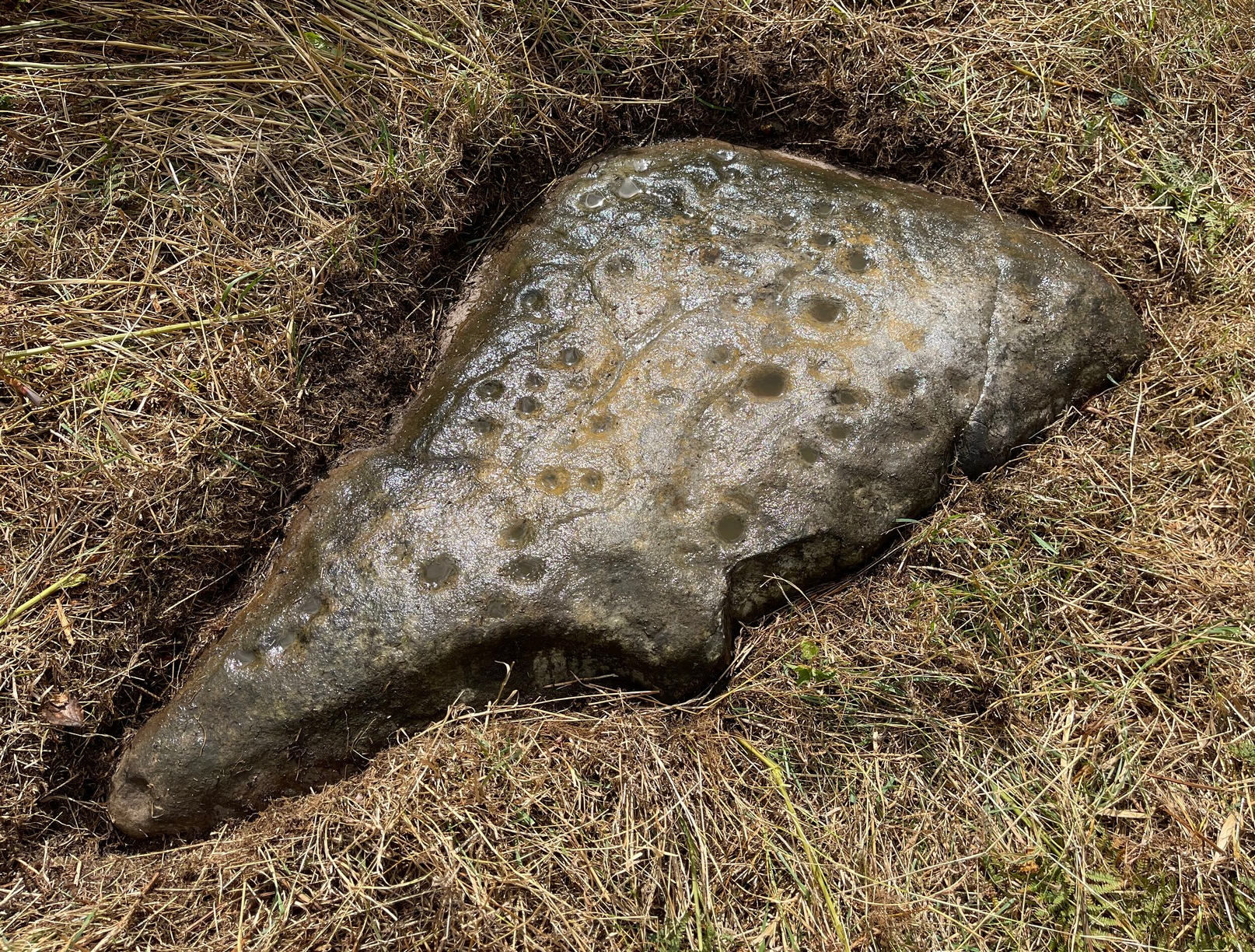
The stone is situated on the north-facing slope of Carrot Hill (almost equidistant with neighbouring Dodd Hill actually) at 225 m OD. Use of a GPS and the co-ordinates above are very definitely recommended for finding this stone which lies flat on a heather covered hillside. You most likely won’t locate it without them. There is ample car parking space at the popular viewpoint car park on Carrot Hill (NO 464 408), walk to the summit trig point and follow your GPS from there.
Archaeology & History
This cup-marked stone was first noticed in February 2012. Remarkably, this stone seems to have been previously unrecorded despite lying just metres from a small path through the heather.
There are at least 15 cup marks on this sandstone boulder which was measured to be 1.2 x 0.7 x 0.2 m in size. There is no evidence of any rings around any of the cups.
The closest known examples of more rock art are just over four kilometers away to the west at Huntingfaulds where there is a cup and ring marked boulder.
Take the road up alongside and past Shipley Glen, taking the turn to go to Crook Farm caravan site. Go right to the very end of the car-park, then walk up the footpath through the trees on your left. Keep going uphill about 100 yards by the field-wall until the land begins to level out – and shortly before the first gate into the field (on your right) keep your eyes peeled for the triangular stone in the ground, barely 10 yards away from the walling. Alternatively, from the entrance into the Dobrudden caravan park walk to the far-end of the level area in front of the little cafe and walk along the footpath that crosses the grassland to the walling nearly 300 yards away (south). Follow the wall down below the gate and zigzag about. You’re damn close!
Archaeology & History
Crook Farm north carving
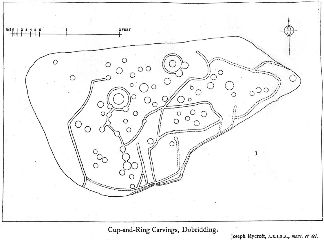
For some reason this has always been one of my favourite cup-and-ring stones on Baildon Moor and it’s well worth checking out if you visit the area! It was rediscovered by the Bradford historian W.E. Preston, who photographed the carving around 1912. Shortly afterwards he took fellow historians Joseph Rycroft and W. Paley Baildon to see this (and others he’d located) and subsequently both a drawing and Mr Preston’s photo of the site was included in Mr Baildon’s (1913) magnum opus the following year.
As you can see from the relative photos—with literally 100 years between them—erosion hasn’t taken too much toll and this neolithic or Bronze Age carving remains in very good condition.
Rycroft’s early drawingPreston’s 1912 photo
Covered with upwards of fifty cup-markings, there are also two cup-and-rings and numerous carved lines meandering around and enclosing some of the many cups. One cup-mark was cut into the narrow end or ‘nose’ of the stone.
It’s a fascinating design, with another ‘Cassiopeia’ cluster of cups in one section, beloved of archaeoastronomers who explore these stones. Mr Rycroft’s drawing of the design (left) is perhaps the best one, to date.
Along this same ridge there are remains of other prehistoric sites, more cup-and-rings, remains of prehistoric walling and what may be a small cairn circle (to be described later).
References:
Baildon, W. Paley, Baildon and the Baildons – parts 1-15, Adelphi: London 1913-1926.
Bennett, Paul, Of Cups and Rings and Things, unpublished: Shipley 1981.
Bennett, Paul, Megalithic Ramblings between Ilkley and Baildon, unpublished: Shipley 1982.
Whether you come via Shipley Glen or Baildon, head for the Dobrudden caravan park on the western edge of Baildon Hill. As you get to the entrance of the caravan site, turn right and walk along the outer walling of the caravan site, up and around for less than 100 yards. Keep your eyes peeled for the upright stone against the outer walling (the famous Dobrudden Cup-and-Ring Stone), and just 10 yards away, laid flat in the grasses, you’ll see this small cup-and-ring stone!
Archaeology & History
Found just a few yards from the well-known Dobrudden Carving that stands up against the wall, this small flat level stone, slowly again being encroached by Earth’s skin, is found on the edge of the High Plain, whereon the usual conjunction of prehistoric tombs and cup-and-rings is found once again. Whether this carving ever had its own cairn or funerary monument is now hard to say for sure; and the excessive erosion of modern humans is slowly eradicating the landscape all round here.
Jackson’s 1956 drawingHedges 1986 drawing
Consisting of two cup-and-rings (with very deep cupmarks in the centres), there are also what seem like artificially carved lines or grooves running across the stone. It was first described in a short article in the Cartwright Hall Archaeology Group Bulletin (Jackson 1956)*, found lying “in the path alongside the north wall of the Dobrudden Farm enclosure.” It seems like stone may have been covered over until some local work on Dobrudden unearthed it in the latter half of the 20th century. There’s also an intriguing note told by a local man called Jack Taylor, which Jackson narrated, saying how he,
“always held the opinion that the rings were not contemporary with the cups, and went so far as to suggest that they had been carved within living memory by someone anxious to ‘improve’ the boulder.”
This might be the case, as there is another carving not far away near the top of Baildon Hill that certainly seems to have been done in the 20th century. And one of the two surrounding rings on this stone does appear to have a more recent look to it than the other. However, we must consider that the covering soil has kept the carved rings in such good condition. (There are examples of petroglyphs throughout the world where certain carved elements were added at later times by countless aboriginal tribes.)
Close-up of cup-&-ringsDobrudden carving 150
Like all of these carvings, to get an accurate picture of the true original we must visit them in all weathers all through the year, to see how differing seasons express the petroglyph. For we can see on some images we have of this carving a number of features that aren’t on the drawings of either Jackson (1956) or Hedges (1986): whether the rings surrounding the cups are ancient or not, there is a definite carved line nearly linking them together; and at least one faint line stretches down from one of the rings. We need to visit the carving again to see if such features show up with greater clarity when lighting conditions are better.
References:
Baildon, W. Paley, Baildon and the Baildons – parts 1-15, Adelphi: London 1913-1926.
Bennett, Paul, Megalithic Ramblings between Ilkley and Baildon, unpublished: Shipley 1982.
Boughey, Keith & Vickerman, E.A., Prehistoric Rock Art of the West Riding, WYAS: Leeds 2003.
Hedges, John, The Carved Rocks on Rombald’s Moor, WYMCC: Wakefield 1986.
Jackson, Sidney, “Another Cup-and-Ring Boulder,” in Bradford Cartwright Hall Archaeology Group Bulletin, 1:13, 1956.
* Boughey & Vickerman (2003) cited W. P. Baildon’s magnum opus (1913) as the first to describe this stone, but this is untrue (there’s certainly no mention nor illustration of it in my editions of the Baildon volumes).
Cup-and-Ring Stone (destroyed): OS Grid Reference – NO 379 204
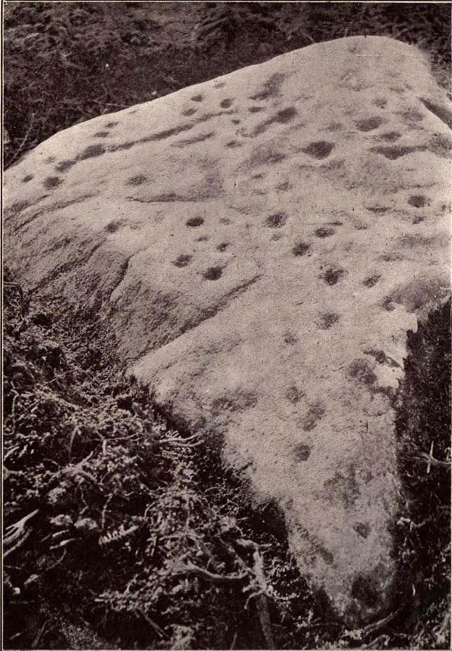
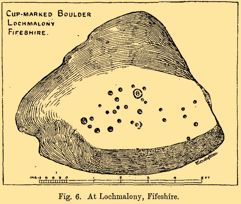
Archaeology & History
J.R. Allen’s 1882 sketch
Here’s another old carving that has succumbed to the lack of animistic respect endemic in modern culture. Ronald Morris (1981) reported that this carved rounded boulder was “dynamited by the farmer and (is) now no longer extant.” First described in 1882 and later included in the Fife Inventory (1935), the large smooth rock used to lay within a nice copse of dense gorse, measuring 2½m x 1¾m across and about 1m high from ground level.
It was uncovered in 1872 and mentioned briefly for the first time in Arthur Mitchell’s (1874) fine essay on the antiquities of Cromar, where he told that “Dr. Batty Tuke tells me there is a cup stone on a moor forming part of Lochmalonie farm, in the parish of Logie, Fifeshire.” His notes were followed up by the great Romilly Allen (1882), whose sketch is all that remains of this ancient site. The carving was subsequently included in one of Ron Morris’s (1981) survey of Scottish petroglyphs, describing it simply as,
“2 cups-and-one-complete ring (one mostly weathered off), diameters 10cm (4in) and 27 cups (carving depth and angle of slope not now known.”
Its isolation from any other known petroglyphs is a little odd and there is every possibility is accompanied a prehistoric burial of some sort; although from the attitude of the farmer, all trace of that would have gone too. On a more positive note, when Batty Tuke spoke with Romilly Allen about this carving, he told that he has “frequently noticed well-marked cups on dry stone dykes in the Glenduckie area.” Petroglyph explorers amongst you might want to spend some time meandering in this neck o’ the woods….
Morris, Ronald W.B., “Fife: Loch Maloney – Cup Marks,” in Discovery & Excavation, Scotland, 1967.
Morris, Ronald W.B., The Prehistoric Rock Art of Southern Scotland, BAR: Oxford 1981.
Royal Commission on Ancient & Historical Monuments, Scotland, Eleventh Report with Inventory of Monuments and Constructions in the Counties of Fife, Kinross and Clackmannan, HMSO: Edinburgh 1935.
At the pub by the bridge which crosses the Falls of Dochart (aptly called the ‘Falls of Dochart Inn’), walk downstream following the dirt-track which runs parallel with a section of the river for a good 5-600 yards. In the field that appears on your right, watch out for the rise of the stones as you approach the large gates which take you into the ground of Kinnell House. You can climb over the gate just into the field and go straight to the stones.
Archaeology & History
Found on the field called Kinnell Park in the grounds of Kinnell House, less than a mile out of Killin, this is a well-preserved site consisting of six stones. It appears to have been described first of all by Thomas Pennant in 1772, in the same breath as the megalithic remains at Lawers on the other side of Loch Tay. Pennant wrote:
“In going through Laurs observe a Druidical circle; less complete indeed than one, that should have been mentioned before, at Kinnel, a little southwest of Killin; which consists of six vast stones, placed equidistant from each other.”
Coles’ 1910 plan of KinnellThom’s geometric plan
It would seem that the site has changed little since Pennant’s visit. Sitting on a reasonably level grassy plain, the hills rise and surround the small ring of stones, with the lower horizons running along the south. Due west (equinox) we have the large pyramidal hill of Meall Clachach; whilst to the north are the legendary hills of Creag na Cailleach and Ben Lawers, each with their own rich mythic archaeological legacies. Legendary stones and wells are also close by, some with rites still enacted by old local people keeping truly ancient traditions alive.
The first detailed archaeological survey of the Kinnell site was done by Fred Coles and published in 1910. It has yet to be superseded. Mr Coles wrote:
“Taking the Stones in the usual order…I here give their dimensions and characteristics: Stone A, 6 feet 3 inches high, springs from an oblong base which girths 11 feet 4 inches, to a rough irregular top; Stone B leans forward towards the centre of the Circle, and measures along its sloping back 6 feet 9 inches, the present height from the ground to its upper edge being 4 feet. It is of smooth garnetiferous schist, and free from the deep fissures and rifts so common in these Stones. Stone C, a very rectangular but narrow block of schist, has a 15 Feet-girth at the base of 9 feet, but tapers up from both ends to a pyramidal summit, 5 feet 4 inches above ground. Its inner face is over 6 feet in breadth. Stone D, 4 feet 6 inches high, is a broad, flat-topped, very massive block, measuring 9 feet 5 inches round the base, but near the middle of its height 11 feet 2 inches. Stone E, the shortest of the group, is only 4 feet high, has a rough, uneven top, and a basal girth of 8 feet 11 inches. Stone F, the tallest, measures 6 feet 4 inches in height, but in girth only 7 feet 3 inches. It is very rough, vertically fissured in many places, and full of white quartz veins.
“Neat, well-defined, and comparatively small as this Circle is, it is to be noticed that the positions of the Stones do not conform to perfect regularity as points on the circumference. On working out the plan, the measurements prove that a diameter of 29 feet exactly bisects three of the erect Stones, B, C, and F, but leaves the other two untouched. The interspaces of the settings are not all quite equal, a space of 14 feet 8 inches dividing the centres respectively of F and A, A and B, F and E, and E and T); but between D and C it is 13 feet 8 inches, and between 0 and B I S feet 5 inches. Yet, the Stones stand proportionally near enough to each other to give one a satisfying impression that these six megaliths represent the group in its completeness, and that there were no smaller blocks between any two of them. The space enclosed by these stones is quite smooth and level, bearing no indication of having at any time been disturbed.”
Many years later, the late great Alexander Thom came here and, with his geometric perspective, gave a more precise ground-plan and lay-out. Thom (1980) defined the site as a “Type B flattened circle, or possible ellipse,” with a perimeter of 35 megalithic yards and diameter of 11.8 MY. Aubrey Burl’s commentary described Kinnell as:
“Six stones of schist stand evenly spaced on the circumference of an ellipse 32ft 7in x 27ft 5in (9.9 x 8.4m) in diameter. The stones are graded in height towards the SW where the two tallest are over 6ft (1.8m) high.”
One of the upright stones was said by Hugh MacMillan (1884) to have had cup-markings on it in the 19th century, when he told of the circle possessing “some seven or eight tall massive stones, with a few faint cup-marks on one of them.” But these appear to have faded, or were cut into the one of the missing stones.
Folklore
Close to the Kinnell circle could once be found a curious large boulder, covered in moss, but with a large cavity in which water gathered. Local lore ascribed the rock to actually be a well, as it was known as ‘The Well of the Whooping-Cough’, or Fuaran na Druidh Chasad, measuring some eight feet long and five feet high. Local people visited the site to be cured of the said disease, but Hugh MacMillan also suggested that the miraculous well-in-the-stone was connected with ancient rituals once enacted at the Kinnell circle, saying:
” it is a reasonable supposition that the Fountain of the Whooping-Cough may have had some connection in ancient times with this prehistoric structure in its immediate neighbourhood…”
He may have been right!
References:
Burl, Aubrey, A Guide to the Stone Circles of Britain, Ireland and Brittany, New Haven & London 1995.
Pennant, Thomas, A Tour in Scotland, 1772 – Part 2, Benjamin White: London 1776.
Royal Commission on the Ancient & Historical Monuments of Scotland, Archaeological Sites and Monuments of Stirling District, Central Region, Society of Antiquaries of Scotland 1979.
Thom, A., Thom, A.S. & Burl, H.A.W., Megalithic Rings, BAR: Oxford 1980.
Wheater, Hilary, Killin to Glencoe, Appin Publications: Aberfeldy 1982.
Go thru Killin and, just past the Bridge of Lochay hotel, take the tiny road on your left. Go down here for 3 miles till you pass the gorgeous Stag Cottage (with its superb cup-and-rings in the field across the road) for another 300 yards, until you see Duncroisk Farmhouse set back on your right. On the other side of the road, go thru the giant deer-gates (close ‘em behind you) to the river-bridge and across it. Walk along the track till you reach the turning to Corrycharmaig House on the right (over the stream), but here, go up into the field thru the gate. Walk up the hill ahead of you with its trees on the left, walking up onto the grassy level, over the deer-fence, then up again to the rounded knoll another 100 yards up. You’re here!
Archaeology & History
On my first visit to this stone, in overcast and wet conditions — the easternmost of at least four separate carved rock faces along the same geological ridge — I only noticed a handful of cup-marks etched onto the northeastern section of the stone. But I was sure there were supposed to be more. And when I returned home to check up, found that Ron Morris (1981) said there were “40 widely scattered cups of which, however, 29 well-defined cups are in a compact group, of which 6 are in a line.” Much more than what I saw! And when I checked further, it was evident that even more cup-marks were once visible on the rock. In the very first description of this carved stone, E.A. Cormack (1952) told:
“On the easterly area there are about 70 small cups, roughly one inch in diameter, in groups of ten to twelve. Most are on the flatter rock surface, but some are on the steeper slope facing south, which also bears the marks of deep glacial scorings.”
A sample of cups on ‘Corrycharmaig 1’
So on our visit here again a few weeks ago when we stayed at Corrycharmaig house*, a couple more visits allowed a slightly better investigation, albeit in even wetter and cloudier conditions than our first visit! And the more we looked, the more we could see; and it was plainly evident that a number of cup-marks had become receptacles for moss-growth! We counted at least 40 cup-markings on this ‘Corrycharmaig 1’ stone, but it seemed pretty obvious that beneath the grasses and vegetation, more carvings would be found.
Walking SSE along the same rocky ridge brings you to the other rock faces of Corrycharmaig (2), (3) and (4) — all with their own carvings. Corrycharmaig 2 possessing the only known complete cup-and-ring on the ridge. More carvings remain hidden nearby…
Morris, Ronald W.B., The Prehistoric Rock Art of Southern Scotland, BAR 86: Oxford 1981.
Royal Commission on the Ancient & Historical Monuments of Scotland, Archaeological Sites and Monuments of Stirling District, Central Region, Society of Antiquaries of Scotland 1979.
Follow the same directions to get to the Corrycharmaig 3 carving; and just a yard or two to the right of the far western edge of the rock, you’ll see another smaller slightly sloping rock, closer to the fencing, with faint cup-markings. That’s the one! (note that the 10-figure grid reference given here might need adjusting slightly)
Archaeology & History
This small slightly sloping piece of exposed rock is on the western extremity of the Corrycharmaig cluster of carvings, but is a distinctly separate piece of rock from the Corrycharmaig 3 stone (though part of the same outcrop). The stone itself has two sections to it, with a natural crack in the rock defining eastern and western section — both of which possess cup-marks.
The easternmost section of the stone has seven cup-marks, some of which were only recently uncovered. A large single cup-mark sits near the middle of this portion of the rock; this is probably what Mr Cormack (1952) was talking about when he told that, “further west (of the Corrycharmaig 3 carving, PB) is one isolated larger cup of 4-inch diameter.” On the western side of the stone, we find just two or three cup-marks, though one large cup-marking here would seem to be Nature’s handiwork.
It is highly likely that beneath the excessive vegetational growth around this carving and others along this ridge, other sections of prehistoric carvings remain to be found.
Morris, Ronald W.B., The Prehistoric Rock Art of Southern Scotland, BAR 86: Oxford 1981.
Royal Commission on the Ancient & Historical Monuments of Scotland, Archaeological Sites and Monuments of Stirling District, Central Region, Society of Antiquaries of Scotland 1979.
Dead easy! Just about in the middle of the village, by the side of the road where a seat allows the weary walker a chance to sit and rest, the Tarry Stone stands before it, with a plaque on the wall above the seat. The old postcard here shows its situation clear enough!
Archaeology & History
The history of this large rock near the middle of Cookham village is important in the history of the old village, though there is no direct evidence to give it a prehistoric pedigree. It was known to be an ancient boundary stone and is included in perambulation records of the area, where local people would annually walk and redefine the landscape of Cookham: a pastime known across the land, but which fell into disuse in Victorian times. Such perambulations are thought to trace way back into the mythic lands of prehistory — so the Tarry Stone here may well have an archaic provenance.
The known history of the stone was gathered and described in Stephen Darby’s (1899) rare work on the place-name history of Cookham. He wrote:
“A stone 3½ ft high, by 4 ft long, and 2½ ft thick. This formerly stood in Cookham village, about two feet from Dodson’s fence, where the roads parted to the church and the ferry. It is now in the Mill Garden at Cookham, where it was removed by the late George Venables when he was church-warden. This stone was formerly known as Cookham Stone.
“A.D. 1506: The tithing man presents that the Warrener ought to hold sports at Cookham Stone on the day of Assumption; and he has not done so (Cookham Manor Court Rolls).
“The stone was originally a boundary stone to the property of the Abbot of Cirencester, whose house was close by, as is shown in the will of John Luffenham, A.D. 1423.”
An old plaque that was once attached to the rock told, “The Tarry Stone at which sports were held before 1507 AD, stood formerly 50 yards NNE and was replaced here AD 1909 by order of the parish council.” The position described “50 yards away” was next to an old pub with the fascinating legendary name of ‘Bel and the Old Dragon’!
Folklore
Dennis Curran’s 1976 drawing
One of the main reasons this site has been included here is the legendary attachments. When the stone was moved from its original position in 1839 by a certain George Venables, to nearby Mill House Gardens, local people told how the Venable family thereafter were cursed. It was thereafter moved back to its earlier site!
The stone has been suggested as a meteorite — a theme that was echoed in Peter Ackroyd’s Thames (2007), but the Tarry Stone is a regional sarsen rock, albeit peppered with erosion holes, giving a more ‘foreign’ look to it!
Cookham was also the village where the spirit of the god Herne “winds his horn and the music of his hounds can be heard from across the common.” (Yarrow 1974) The stone was also the focal point of village games in earlier centuries.
References:
Ackroyd, Peter, The Thames: Sacred River, Chatto & Windus: London 2007.
Darby, Stephen, Place and Field-Names of Cookham, Berkshire, privately printed: London 1899.
Hallam, Elizabeth, Domesday Heritage, Arrow: London 1986.


")
")