Cross (destroyed): OS Grid-Reference – SE 3224 4498
Archaeology & History
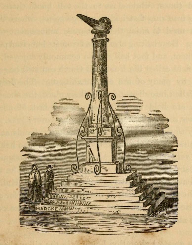
A Charter in the time of King John allowed for markets to be held in Harewood from 1209 CE onwards, “on the first day of July and the two following days, and also to hold one market there every week on the Monday.” But whether or not a market cross was erected that far back, we don’t quite know. Certainly, the edifice illustrated by John Jones (1859) in his standard work on Harewood didn’t date from such an early period! It stood close to the old road junction to Wetherby in old Harewood village, “a little below the intersection of the roads, and about fifty yards higher up than the market house.” Jones told us:
Harewood Cross (Jones 1859)
“It stood upon a large stone pedestal, and was approached by a quadrangular flight of seven steps, very broad, where the neighbouring farmers used to stand, and dispose of their butter, fowls, eggs, &c. It was re-erected, AD 1703, by John Boulter, Esq., and in the year 1804, when the road was lowered, it was taken down and destroyed. This is to be regretted, it might have been re-erected in another situation, if that was inconvenient, and would have been in the present day, not only an ornament to the village but a relic of the past, of which the villagers might have been justly proud. On the top of this cross there was a knur and spell, a game for which the village was celebrated in old times, while close to the toll booth there was a strong iron ring fastened to a large stone, where the villagers used to enjoy the barbarous amusement of bull baiting.”
References:
Bogg, Edmund, Lower Wharfeland, J. Sampson: York 1904.
Jones, John, The History and Antiquities of Harewood, Simpkin Marshall: London 1859.
Speight, Harry, Lower Wharfedale, Elliott Stock: London 1902.
Cup-and-Ring Stone: OS Grid-Reference – C 30754 37541
Archaeology & History
Incredible setting -incredible carving
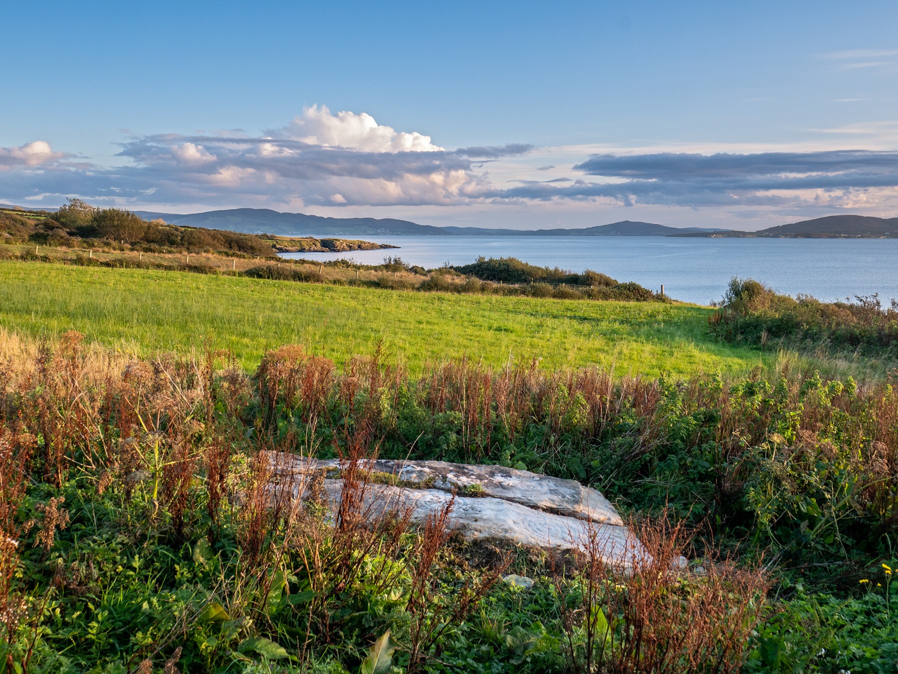
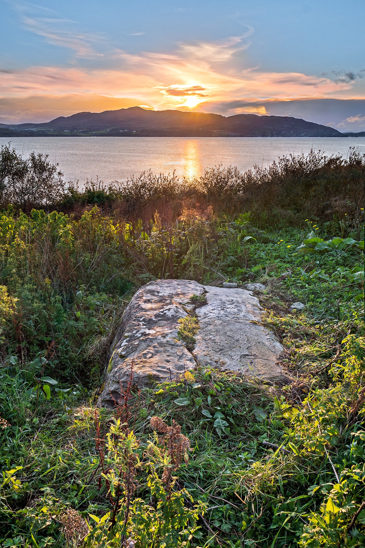
This is an incredible find—dare I say a beautiful find—uncovered beneath the soil a few years ago on farmland close to the shore of Loch Swilly by one of the farm-workers. We were lucky inasmuch as when it was found he noticed curious markings on it. Informing the farmer, between them they peeled back the rest of the soil and found the incredible carving that we see here in Bettina Linke’s photos.
Etched onto a sloping stone overlooking the blue panorama that is Loch Swilly, this petroglyph has a 180º view of the landscape, from the southeast through to the northwest. This panorama—unimpaired by trees thanks to its proximity to the sea loch—was probably an important ingredient in the mythic function of the carving and is something we’ll return to shortly…
Local rock art specialist, Liam McLaughlin was informed of the discovery and, along with Bettina Linke, they met up with the farmer who showed them the carving. I have little doubt that they were very impressed by what lay before their eyes! They told that the rock,
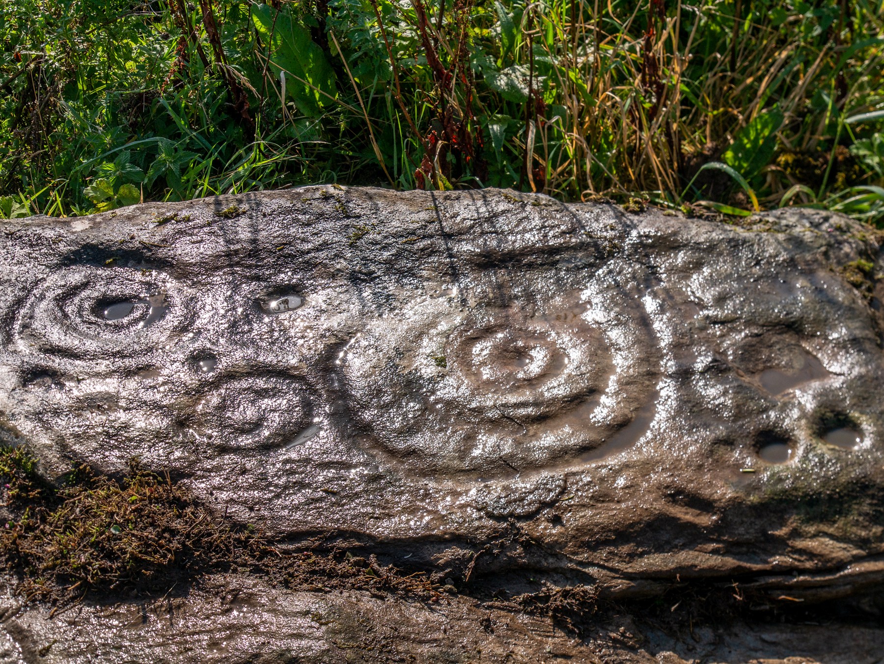
“is aligned east-west with the visible motifs, apart from a few cup marks, situated at the western end of the outcrop. Interestingly, the northern half/leaf is little worn and individual peck marks, made millennia ago, are clearly visible, suggesting it may have been covered for most of the time. The southern half is clearly worn and smoothed out and therefor appears to have been exposed for a considerable amount of time.”
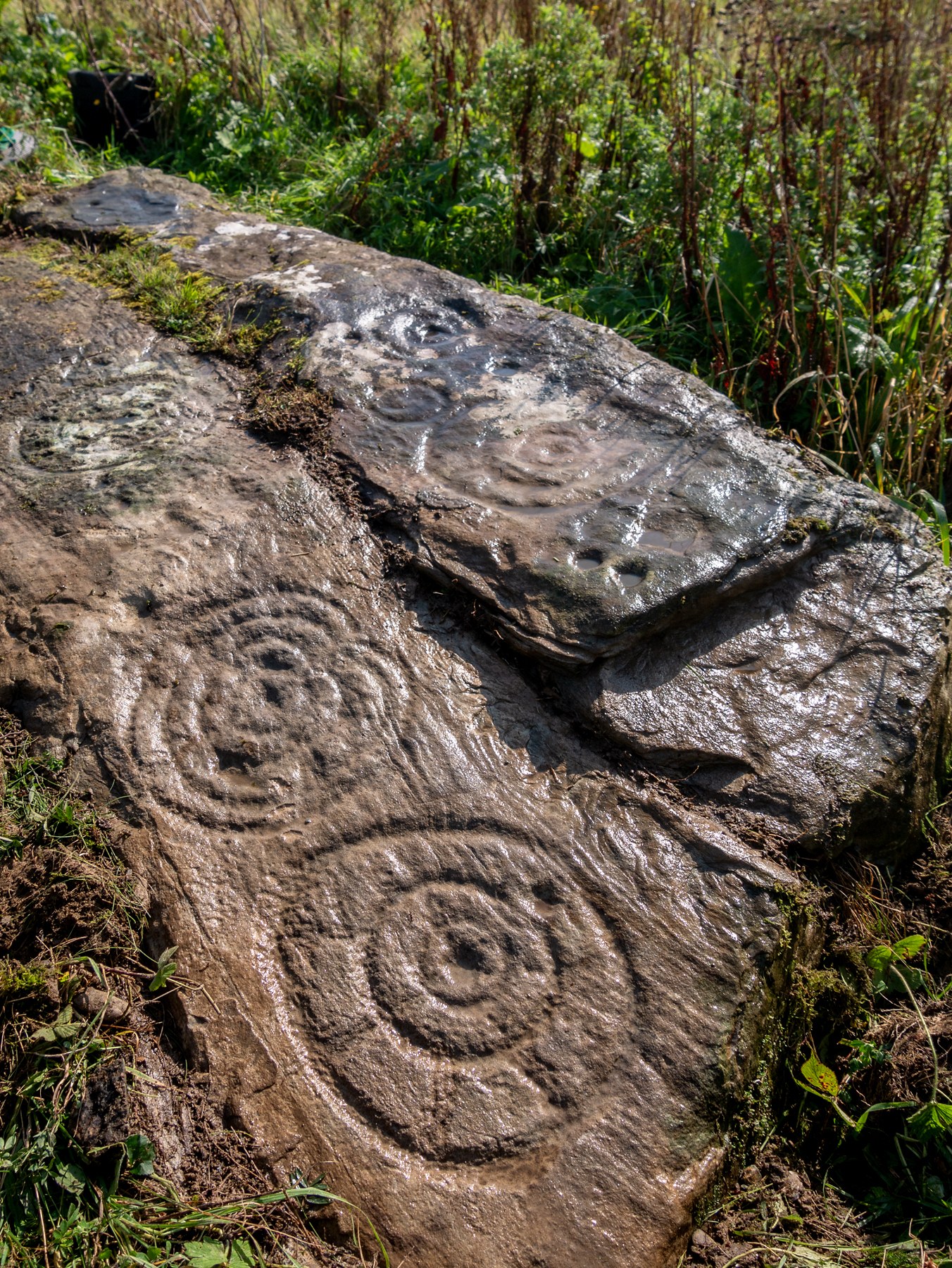
Archetypal cup-and-ringsAncient solar motif?
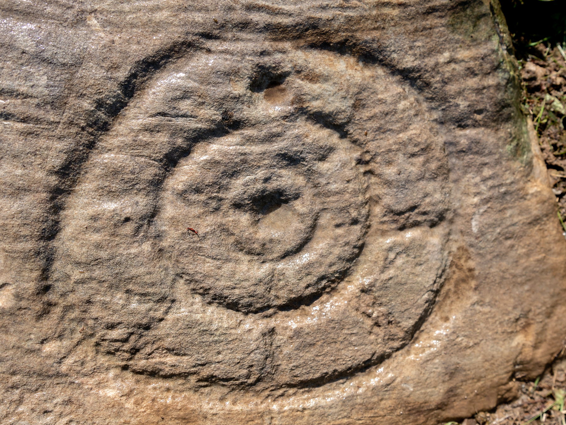
One of the most impressive elements in the overall design is the solar motif, i.e., a series of concentric rings (in this case three) with a number of ‘spokes’ reaching outwards as if to indicate the rays of the sun itself. This is shown clearly in one of Bettina’s photos here. This symbol is found on other neolithic carvings in Ireland: not least the incredible designs in the Newgrange complex where the solar alignment is unmistakable.
The discovery of the carving was reported to the Irish National Monument Service and added to the Heritage Environment Inventory where a detailed report was subsequently written, much of which is extracted here:
“The rock art panel is on an outcrop of bedrock, aligned east to west and slightly sloping in this direction towards Lough Swilly and Knockalla Mountains, also known as the Devil’s Backbone. It lies in an arable field near a field wall in rough ground. Visibility is good to the SE, S, W, and NW across Lough Foyle and the Fanad peninsula.”
On the northern section of the stone,
“There are three large motifs and well preserved with cup and pecking marks between them. There are traces of a fourth large motif on the east end but the rock surface has been eroded or damaged, making it impossible to ascertain the design of the motif.
“Starting from west to east, the top large motif has three rings and a diameter of 43cm. The centre cup mark is shallow and has a diameter of 5cm. There is second shallow cup mark between the 2nd and 3rd ring in the southern part of the motif. Its diameter is 3cm. One tail, is running from the inner ring outwards to the west and a second one is running towards the north. Peck marks, covering the motif, are still visible, particular in the rings.
“The motif below has four rings and a diameter of 39cm. The centre cup mark is very shallow and has a diameter of 4cm. And like in the above motif it has a tail running northwards. But a special mentioning has to be made of the unusual heart shape of its rings with the indentation to the south. Peck marks are still visible in the rings. As far as could be made out, there are five cup marks between those two motifs with diameters between 3cm – 5cm. This part also contains several single peck marks of about 1cm in diameter.
“The next large motif below has a diameter of 37cm, three rings and a centre cup with a diameter of 3cm. A tail appears to divide the motif into an eastern and western half. Another tail seems to run from the centre cup through the inner and middle ring towards east.
“Large peck marks of 1cm diameter cover the entire motif, which can be particular well seen in the embossed space between the middle and outer ring. There are more, large peck marks above the motif to the west as well as four possible shallow and small cup marks. Although the two closed to the motif, in what appears to be a twin configuration, could be two independent but slightly damaged peck marks.
“All of the three motifs on the northern wing leave the distinct impression that they may have been sun wheels with some spokes no longer visible or not visible during our visits.
“The southern wing:
“Like the northern ring the large motifs are placed in the western end of the wing with only a few cup marks on its eastern tip. The edges of the carvings are rounder and more worn, although some rings and cup marks are distinctively deeper. The latter might suggest that these motifs were carved at a different time and by different hands. It also appears that this wing was longer exposed than the northern one.
“The motifs are as followed from west to east: two deep cup marks on the northern side. Diameter for the upper one 5cm in diameter, for the lower one 4cm. There could be a shallow third one below and a damaged one to the south.
“Next in the centre of the wing is a large, three ringed motif with a diameter of 40cm and a centre cup mark, 3.5cm in diameter. Some of the photos show possible if faint tails or spokes, suggesting that this also could be a sun wheel motif. No visible peck marks. Below is a small double ring motif with a diameter of 17cm and a centre cup mark with a diameter of 2cm. Just below and to the south-east is a cup mark, circa 3 cm in diameter. Beside it to the east another cup mark about 5cm in diameter. There are one or two, maybe three circa 2.5cm cup marks in the white lichen area to the north-east of the small ringed motif. And some faint peck marks appear between the large 3 ring motif above and the small ringed motif close to the natural split of the bedrock. The next motif below is a deep double ring motif with a diameter of 26cm and a centre cup mark of 5cm. No tails or spokes could be detected. The white lichen area with up to three possible single cup marks is just beside it, close to the natural dividing crack.
“In the middle of the southern wing are faint traces which suggest that there could have been another motif, now destroyed, of an estimated diameter of 28cm.
“The eastern tip has one large cup mark of 10cm and 3 small cup marks between 2.5cm and 3cm. There might be a fifth but damaged cup mark.”
Somerville’s astronomical linesThe setting sun: a mythic function?
The fact that the stone itself is aligned east-west and pointing towards the outline of the Knockalla Mountains, suggesting “a solar/sunset alignment at the equinoxes” may well be true, but whether this was intended or not is another matter.
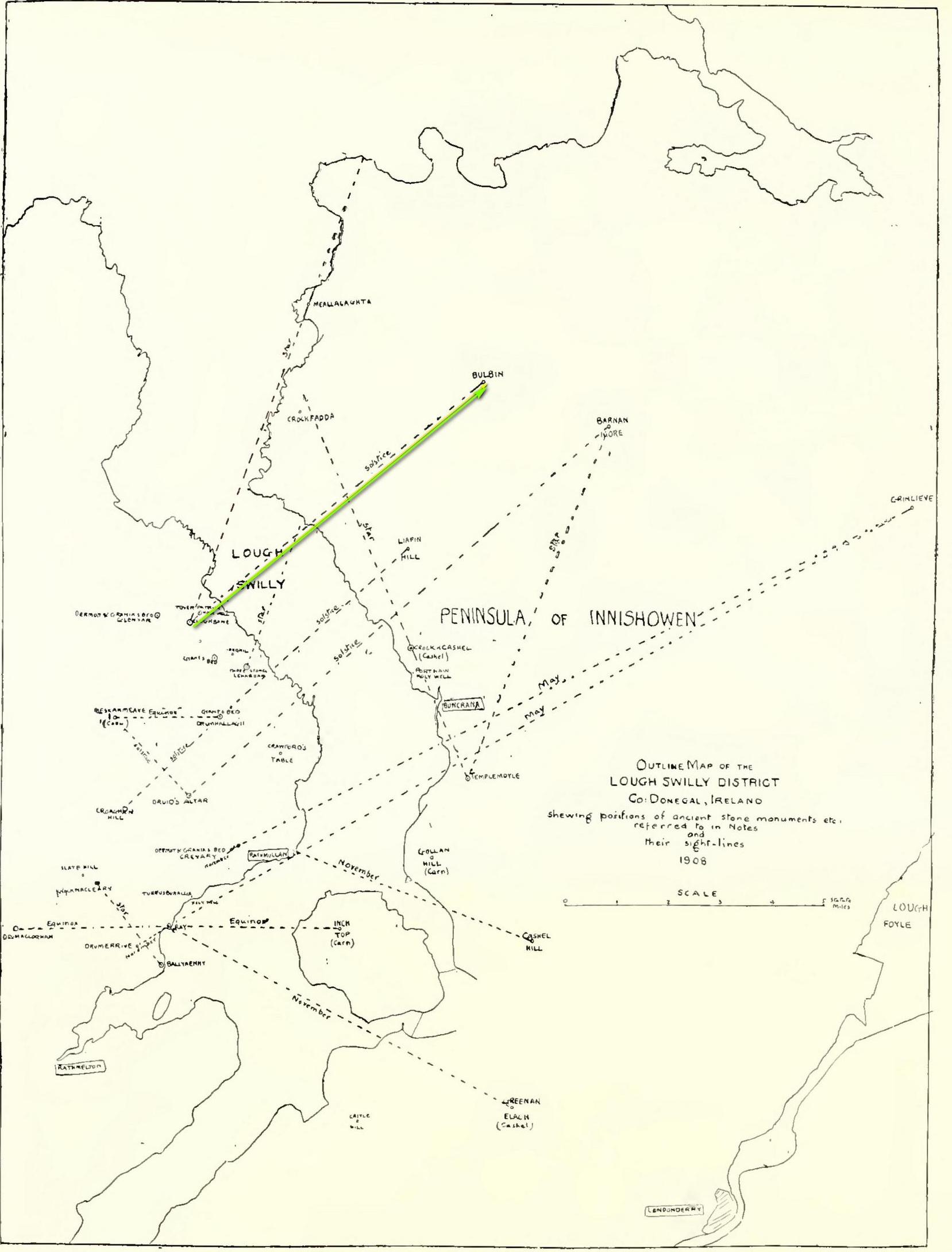
Intriguingly, one of the archaeo-astronony pioneers, Boyle Somerville (1909) wrote a article in the Journal of the Royal Society of Antiquaries of Ireland about a number of summer solstice alignments he thought existed in this precise locale. Amongst them was one he found running from the standing stone at Cloghbane on the other side of Loch Swilly—known as the White or Rowan Stone—heading northeast to the small mountainous peak of Bulbin, approximately 7.1 mile away. Somerville found that,
“The outline of the mountains visible to the northward from Cloghbane shows two sight-lines that undoubtedly were used from this position. One is for the summer solstitial sunrise over the prominent peak Bulbin; the other is over a low and small but conspicuous round-topped headland, towards the mouth of the Lough, which is in line with an exactly similar hill behind it; their two summits being practically coincident, forming a single sky-line; so that, from Cloghbane, their angle of elevation by theodolite is the same.”
The primary motifs
The first alignment is the relevant one here: it not only relates to the rising sun at solstice in 1000 BC, but our Glebe petroglyph lies right on the edge this alignment! (give or take a few yards) Whether or not this is a coincidence we cannot say for certain, but the ‘solar motif’ in the design would seem a strong indicator that implies some sort of solar function here.
As always with cup-and-rings, their non-linear designs tickle our minds with possibilities, probabilities and that there thing called the mysterious, which Einstein described as “the source of all true art and science…”
One final and important thing to anyone who may want to visit this site: please contact the farmer and ask his permission if you want to see it. Cheers. 😉
Acknowledgements: Massive, huge huge thanks to Bettina ‘Grianan Swilly’ Linke for the superb photos and data for this site profile. And (although he doesn’t know it yet!) thanks are also due to the farmer and his employee who rediscovered the carving and to Liam McLaughlin who put pen to paper and told the rest of us about it.
Follow the same directions as if you’re visiting the impressive Fairy Stone carving, then 3 yards east is the Cottingley 2 double cup-and-ring, keep walking past through trees for another 5-6 yards where you’ll come across this reasonably large curved flat stone. Y’ can’t really miss it
Archaeology & History
Cup, with ring faintly visible
This was another carving in the small cluster by the Fairy Stone that I found on my visit here in the 1980s—but it’s a pretty innocuous one to be honest. There’s a faded incomplete “ring” (not really visible on my photos due to pouring rain and very poor light when I was here) with a distinct cup-mark in the middle. Several inches away from the cup-and-ring is a carved line that arcs around it creating an incomplete oval design; and what seems to be a single cup-mark is visible at the top of this oval. Other marks on the stone are both natural as well as recent ‘scratches’.
Some elements of this carving—as with others in this petroglyph cluster—seems to be modern. The cup-and-ring seems to be the real deal, but the ‘oval’ seems to have been added much more recently, perhaps by the scouts who play around in this part of the woods.
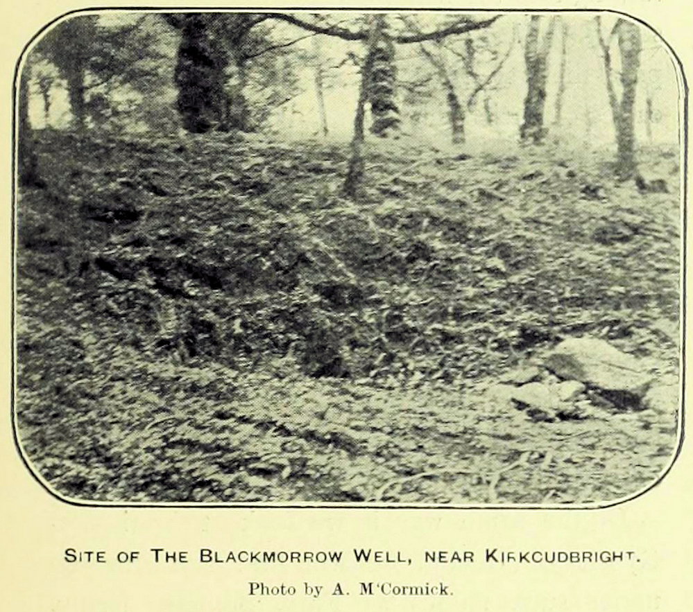
A curious little-known site with more of a Scottish genealogical history behind it. Mentioned in McCormick’s (1906) fascinating survey of tinkers in the Galloway region, the site was given a more succinct description in the Morris survey (1982), where they told that,
Well shown on 1854 mapBlack Morrow Well, c.1905
“a mile from the town in Black Moray (formerly Morrow) Road, a short distance from the road…was this well that the MacLellan family are said to have derived their crest of a Moor’s head impaled on a sword. The local story is that James II wanted to get rid of some gypsies infesting Galloway and offered the Barony of Bombie to anyone who could do so. MacLellan filled the well with potent liquor which the gypsy chief drank to excess and while he was in a drunken stupor MacLellan killed him, cut off his head and presented it to the King on the point of his sword, immediately receiving the barony as his reward.”
This story goes way back and was first mentioned in 1680. According to McCormick (1906), the name Black Morrow derived from the “More”, the title given to the leader of the so-called gypsy clan, “or, as tradition suggests, a man named Black Morrow, of Irish tinkler descent.”
Souterrain (lost): OS Grid Reference – NC 6601 6315
Archaeology & History
In the middle of the 19th century the opening to a prehistoric souterrain used to be in evidence on the north-side of the single track road running past old Skerray Mains house. It was mentioned in Hew Morrison’s (1883) historical guide, albeit briefly and without ambiguity:
“Below the house of Skerra Mains is an artificial cave that enters from below the road and extends 40 or 50 yards in length. Two urns were found it when it was discovered but they soon crumbled away on being exposed to the air.”
More than thirty years later, the Royal Commission (1911) lads ventured to check it out, only to find that it had just recently been covered up:
“At the farm of Skerray Mains is an earth-house, the mouth or entrance to which was recently exposed by the farmer. It is situated about 15 feet distant from the northeast window of the dwelling-house, and is now entirely covered over again.”
Of the old locals I met here, only one of them remembers hearing of it, but the precise location of its entrance had been forgotten. Surely it aint gonna be toooo difficult to find it again?
References:
Morrison, Alex, “Souterrains in Sutherland,” in J.R. Baldwin’s Province of Strathnaver, SSNS: Edinburgh 2000.
Royal Commission on Ancient & Historical Monuments, Scotland, Second report and inventory of monuments and constructions in the county of Sutherland. HMSO: Edinburgh 1911.
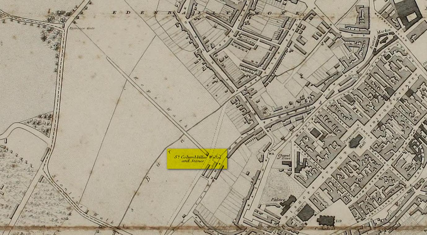
Not to be confused with the other St. Columba’s Stone at Shantallow, 1¾ miles to the north of here, this legendary rock was found in very close association—barely ten yards away—with one of St. Columba’s holy wells (in fact there were three holy wells hereby, but the others were dedicated to saints Adamnan and Martin). The two sites were inextricably related to each other, both in terms of their proximity and, more importantly, in terms of the symbiotic traditions the two of them had. And despite the relationship they had under the guise of one “St. Columba”, it’s pretty obvious that this was a thoroughly unchristian place to begin with.
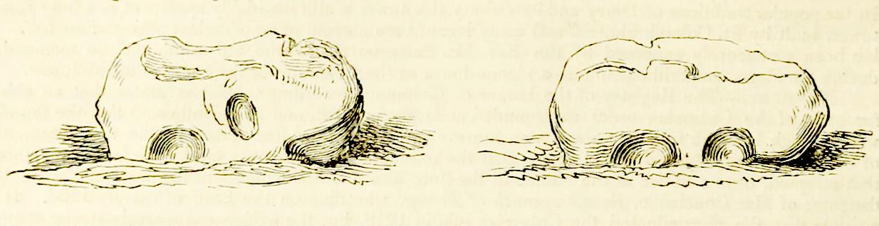
St Columba’s Stone in 1837
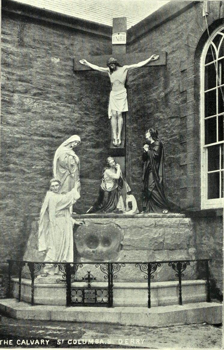
As with many bullauns, it’s a relatively small stone with two deep hollows on either side. We don’t know for certain when the stone was placed here, but tradition tells us it was sanctified at this spot in the 6th century; and so it remained until June 9, 1897 when, deemed as being an “obstruction” on the roadway, it was uprooted and moved some 300 yards south where, a year later, it was incorporated into the base of a cross outside the Long Tower Church of St Columba, where it remains to this day (at grid-reference C 4303 1635).
The stone was still in situ when Thomas Colby (1837) and his mates were doing their work for the Irish Ordnance Survey, at a period when many an Irish antiquity was still frequented by local folks for ceremonies, both personal and social. Colby wrote:
The stone set beneath the cross
“In the centre of St. Columb’s Lane, adjacent to the Wells, there is a remarkable stone, called St. Columb’s Stone, which is popularly regarded with a still higher veneration by the aboriginal Irish of the district. It is of an irregular form, about three feet long, and ten inches wide: the height above ground is one foot and a half, and it has two oval hollows on each side, artificially formed. Many foolish legends are current among the peasantry respecting the origin of these hollows, which, it is supposed, are the impressions made by the saint’s knees when he leaped from the nail of the city. It may, however, be worth observing, that stones of this description are found in the vicinity of most of the Irish churches, and usually bear the name of the founder, or patron saint: they are always held sacred, and the rain-water, deposited in their hollows, is believed to possess a miraculous power in curing various diseases.”
William Doherty (1899) told how parts of the bullaun holes had been made “by pious pilgrims trying to remove chips as relics”, who then wore them as amulets for curative properties and good fortune; then later, “it was utilized as a Holy Water Font, to prevent further mutilation.”
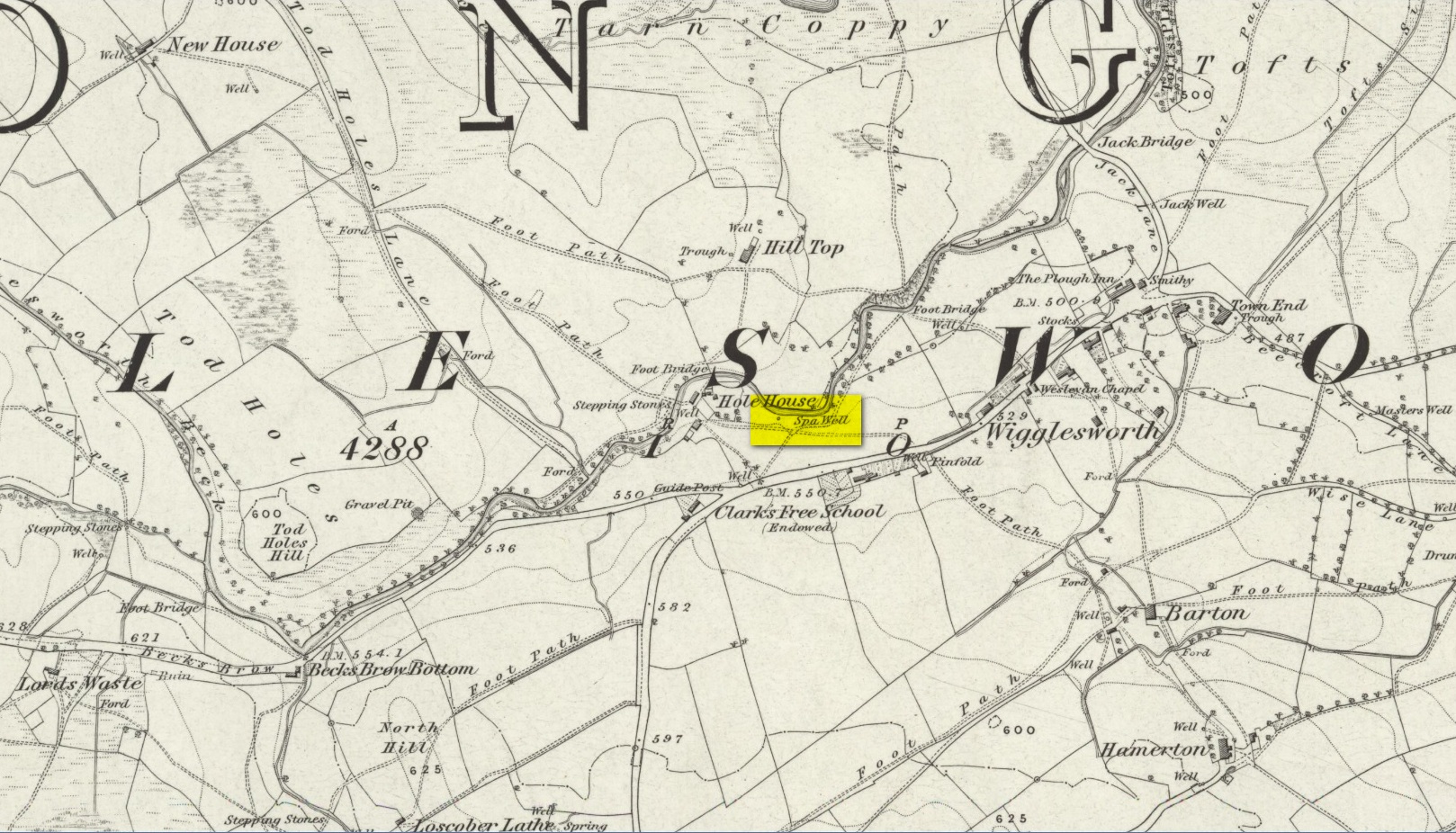
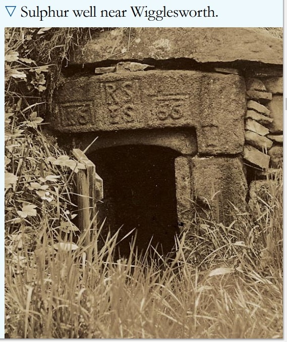
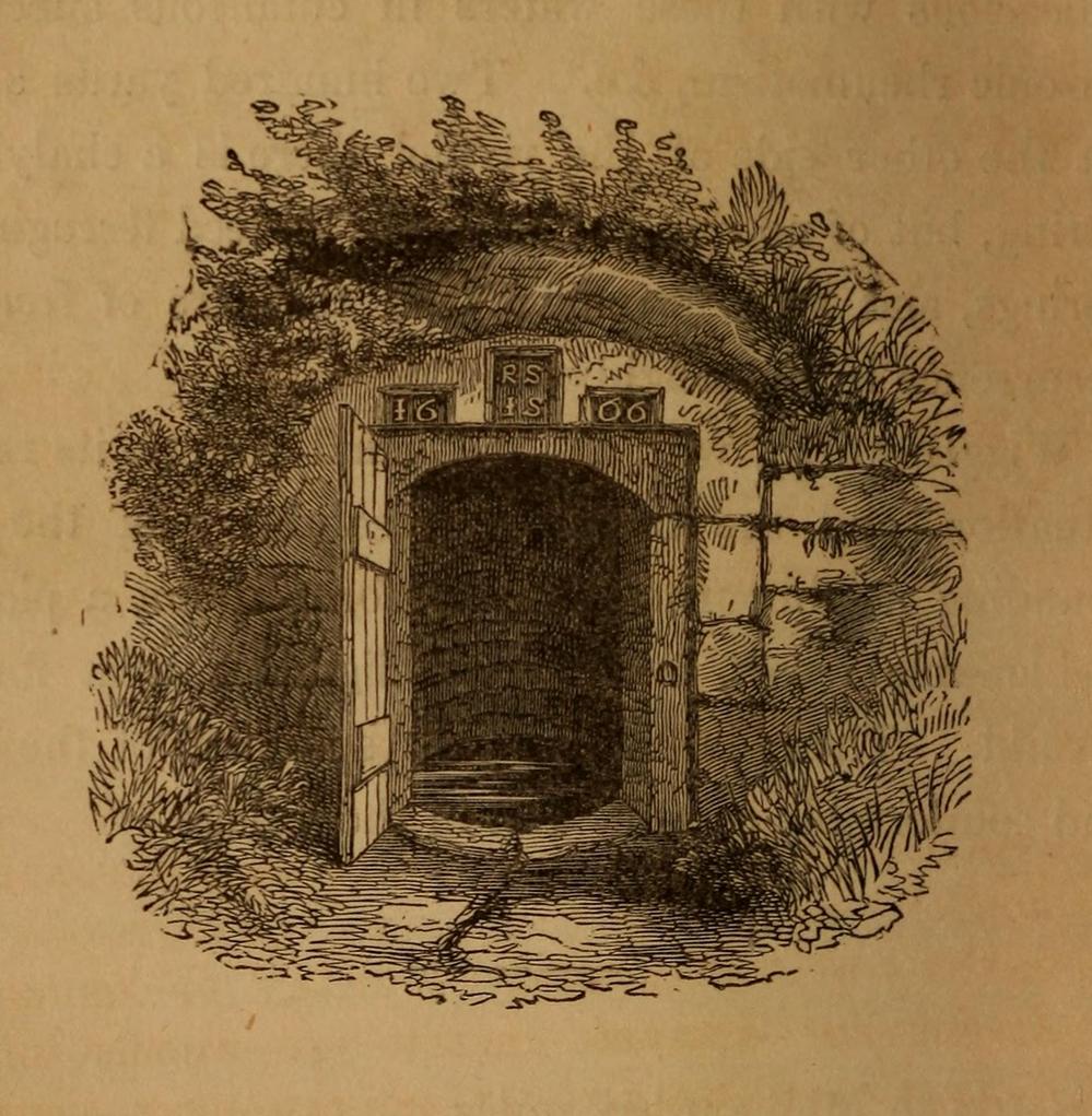
In William Addison’s (1951) standard work on the history and development of Spa Wells, he told us that “the spas began as holy wells”; yet in spite of him listing the Wigglesworth Spa in his work, such “holiness” wasn’t a feature found here and, sadly, we have no written records that tell of any. But that doesn’t mean to say it had no sense of importance or animistic sacrality to local people. The earliest written record we have of this Sulphur Well is to be seen on the stone-work at the top of the small well-house, where the year “1666” was carved, marking the year when the structure was built under the directions of a local rich dood. But earlier knowledge of these healing waters would have been passed to the land-owner by local people, as indicated in Thomas Short’s (1765) words where he told that “it has been used time out of mind.”
Mr Short (1724) makes mention of this Sulphur Well in his gigantic early work, but only in its similarity in both taste and smell to the Sulphur Well at Harrogate and letting us know that, “I have tried carefully” the waters of the two sites. We had to wait another forty years before he gave us a more detailed account of the medicinal properties here. He wrote,
“Now come we to a sulphur water of a very peculiar nature, such as I never met with or heard of in England besides, and deserves to be much more strictly examined and enquired into, viz. Wigglefworth Spaw, near Settle, in the parish of Long-Preston. It has been used time out of mind, and more formerly than at present, because it is little known; rains and drought affect it not. Country people drink four or five pints of it in a morning to vomit them, and six or seven pints to purge them. The water is very black, smells strong of sulphur, has a very small stream, but stagnates not, bubbles not, but springs up; it is always covered with a white scum, (and) dies all in its course white. It rises out of a great stone soil, near much lime-stone, at the foot of a hill. It tastes salt, yet curdles not soap, and boils with milk. A phial glass, one third part full of it, well corked, and tied down with a bladder, and set in the cold water to be evaporated; when the water began to boil, it was taken out and poured a little of it on solution of silver, which turned black and curdled. The phial was corked again, and set half an hour longer in the boiling water, it still turned solution of silver black. It was corked a third time, and set half an hour longer in the boiling water, then tried, but was not so black as before, and caused little curdling. This last stood all night, next day its precipitation was blackish; the water was clear above. This is the only blackish sulphur water I have met with (as Rippon is a greenish yellow) and retains its sulphur the longest, from its contained oil.”
Consistent with other writers of his time, Mr Short then wrote at length on how the Wigglesworth waters reacted to various chemical tests, many of which were done in order to indicate the veracity, or otherwise, of any medical qualities. He also made comparative studies between this and the sulphur wells at Harrogate and elsewhere, and concluded that the Wigglesworth Spa would successfully deal with the following ailments or conditions:
“Sloth, idleness, too violent slavish exercise or labour, too great affluence, or plenty of nourishing rich high foods, spices, forced meats, acrid, stimulant and aromatic viands; the earthy viscid dregs of fermented liquors, or the parching, drying, shriveling spirits of wine, sugar, fruits, grain, or fermented liquors, as well as poverty and unwholesome diet, irregular hours, etc, are the parents of many diseases, whose cure lies in relieving oppressed nature from the unwieldy load (brought upon her by indolence, gratifying the vitiated taste, intemperance and debaucheries) by cleansing and rousing the vessels, restoring the juices to a healthy state; rectifying and establishing the secretions and excretions of the body, and restoring vigour and activity to the fibres, vessels and solids. To the above causes of diseases, we may add pride, luxury, sensuality, inverting the natural course of time, turning day to night, and night to day. These give birth to many chronic diseases, as well as acute, from acidities, crudities, viscidities in the stomach, communicated thence to the bowels, and so to the whole habit; hence are vitiated juices, great obstructions, and a long train of diseases affecting sundry parts of the body, and therein the whole nervous system, with hypo, hysterics, melancholy, costiveness, or looseness, suppression of natural necessary discharges, etc., which require thinning, relaxing, resolving, opening, or invigorating remedies.”
Photo of the well, c.2008Howson’s 1850 sketch
For about two centuries this well had a very favourable reputation. It’s therefore slightly curious as to why the great spa-writer, A.B. Granville, in his visit to this part of Ribblesdale to seek out some of the medicinal springs in the 1830s (including a petrifying well), made no mention of our Sulphur Well. Whether this was due to his patronizing attitude towards local people isn’t known, but it certainly wouldn’t have helped him in Yorkshire! One might suggest it was due to the fact that the spa had fallen into disuse, but this wasn’t the case because, subsequent to Granville’s visit, the local writer William Howson (1850) later told us that,
“In the woody dingle to the north of the village is a sulphurous spring, protected by a neat and antique stone canopy bearing the date 1666, and the initials of Sir Richard Sherburne and Isabella his wife, a daughter of John Ingleby of Lawkland Hall. Of this well, Dr (John) Murray the well-known analytical chemist says, ” It is a most valuable and unusually strong sulphuretted water, and as far as I have examined mineral waters, second to none.” From his analysis and that of Dr. Garnett it appears that a gallon of the water contains seventeen cubic inches of sulphuretted hydrogen, four of azote, and a small portion of carbonic acid, sulphate of magnesia in the proportion of seventy five grains to a gallon, a considerable quantity of muriate of soda, and a minute proportion of carbonate of lime.”
(The aforementioned Dr Garnett was a renowned 18th century authority on medicinal wells in Yorkshire, best known for his works on the spa wells of Halifax (1791) and Harrogate (1791, 1792), along with some in Scotland.)
Messrs Short (1765) and Howson (1850) mentioned other medicinal springs very close by, including the Chalybeate Well in the field immediately north on the other side of the stream.
References:
Addison, William, English Spas, Batsford: London 1951.
Brown, G.H., Walks, Drives and Excursions around Settle, Craven Printing: Settle 1880.
Sacred Well (destroyed): OS Grid Reference – SE 17567 35473
Also Known as:
Pendragon Well
Archaeology & History
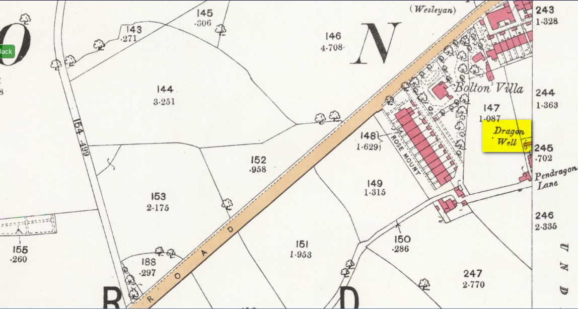
Site on the 1893 map
A most curious place: this ‘Well of the Dragon’ as it was first called (on the 1852 OS-map) and subsequently the ‘Pendragon Well’ (on the 1922 map) just off Pendragon Lane, seems to have been forgotten in both folklore and history. I grew up round here and no legends of dragons were known, either in my life, nor that of the old folks I knew; nor any pub of that name that might account for it.
Equally unexplained is the name of the adjacent ‘Pendragon Lane’, which has been known as that for some 175 years. We have no Arthurian myths anywhere in West Yorkshire that remains in folk memory—and certainly nothing hereby that accounts for it.
As for possible landscape associations (i.e., serpentine geological features), nothing in the vicinity has any bearing on the name. Indeed, the only thing of any potential relevance was the former existence of a healing rock known as the Wart Stone, some 100 yards to the east at Bolton Junction. Such stones are usually possessed of naturally-worn ‘bowls’ of some sort on top of the rock—akin to large cup-markings—into which water collected that was used to rid the sufferer of warts or similar skin afflictions. But such an association seems very unlikely.
The only thing we can say of this Dragon Well is that probably, in times gone by, a folktale or legend existed of a dragon in the neighbourhood that had some association with the waters here. Dragons are invariably related to early animistic creation myths, and this site may have been all that remained of such a forgotten tale. The nearest other place in West Yorkshire with dragon associations is six miles northwest of here on the south-side of Ilkley Moor. In Britain there are a number of other Dragon Wells, the closest of which is in South Yorkshire.
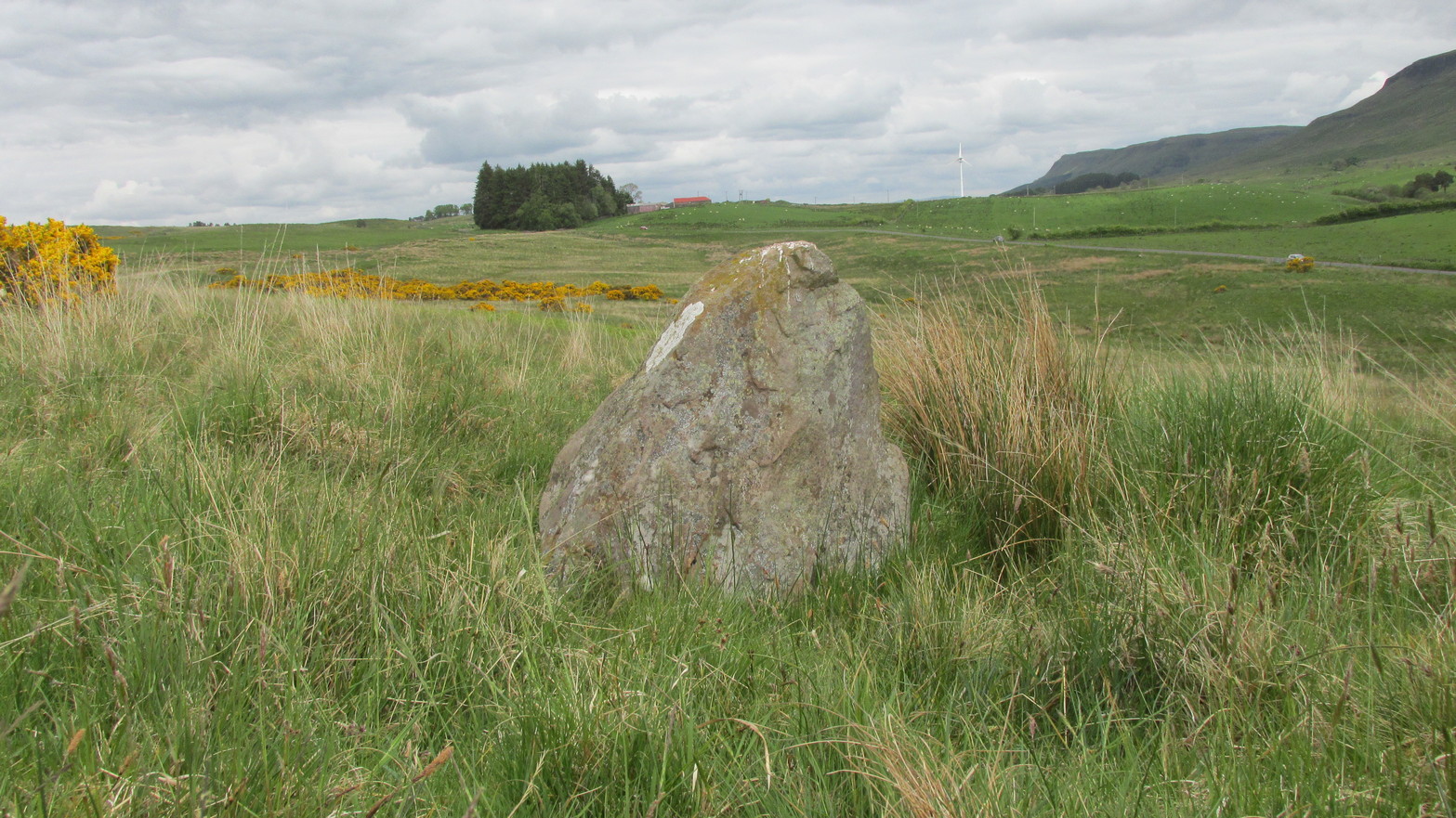
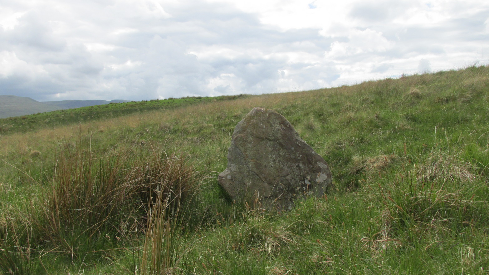
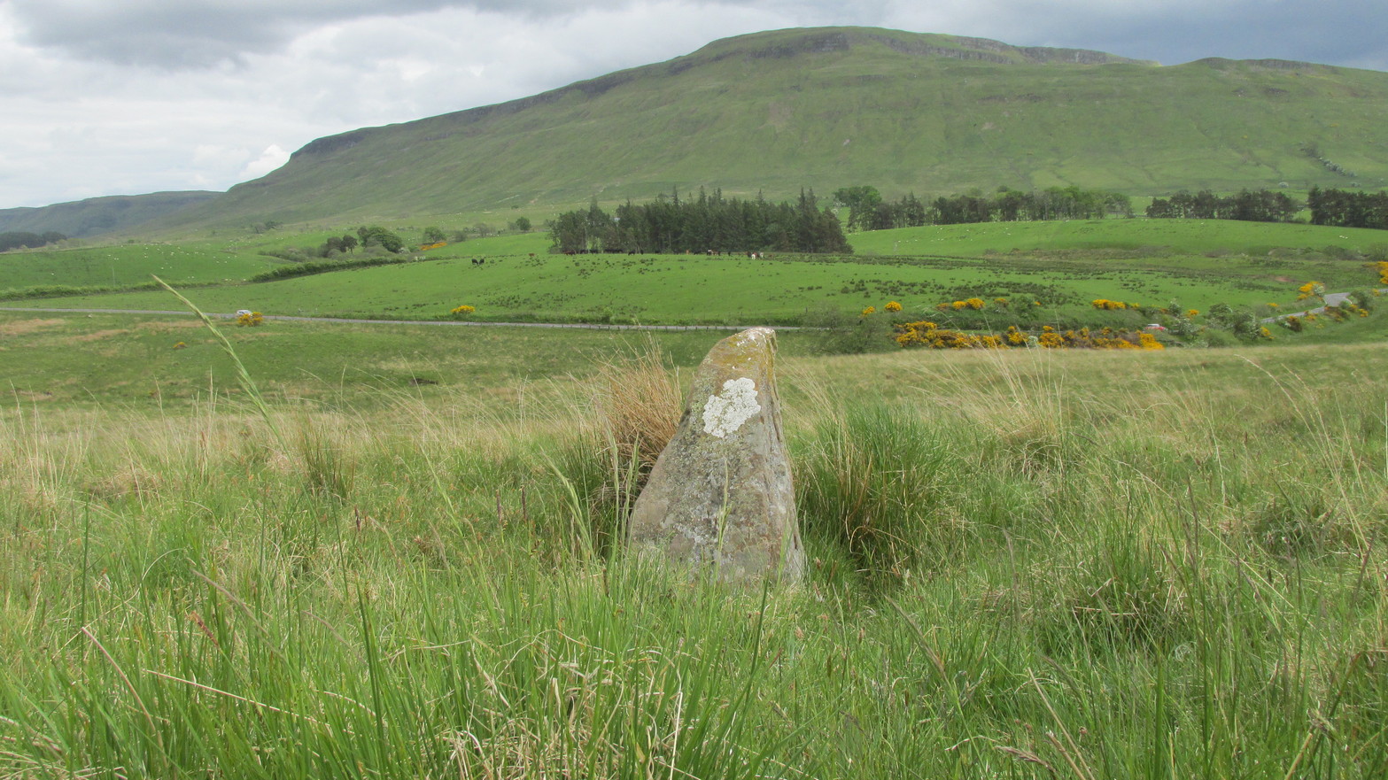
Go up the B822 road from Fintry for literally 2.5 miles (about 500 yards below the small copse of trees that almost hide Balafark Farm above you) and at a very small ‘parking’ spot are 2 farm-gates. Go through the lower of the two and head downhill, crossing the small burn and up the other side for just over 100 yards where you’ll meet a very low, old and very overgrown wall. Keep your eyes peeled for it! Walk left along this wall, uphill, for another 100 yards till you meet a a dried-up dyke that runs downhill. 10-15 yards down this, a small stone greets you…
Archaeology & History
It’s difficult to call this a ‘standing stone’ and, as far as I’m concerned, is even more troublesome to cite it as a legitimate prehistoric monument. Nevertheless it is shown on the modern OS-maps as such and was listed by the Royal Commission (1963:1) lads in their standing stones inventory. But it’s really pushing it to be honest! They told us:
“This stone stands about 180 yds NW of a gate which opens off the Fintry-Kippen road, 340 yds N of its crossing of the Lernock Burn. It is triangular in profile and wedge-shaped in section, measuring 3’3″ both in height and breadth along its base, by 1’7″ in greatest thickness. It may well have been a boundary stone as it is near the corner of some ground which is enclosed by a turf dyke and has been cultivated.”
Looking southwestLooking up to the ancient cairn of Stronend
In truth, if we call this a standing stone, then there are hundreds of others that I’ve come across over the years—frobbling off-path across huge swathes of moorland—that must also be added to our prehistoric inventories, as the height of this isolated rock is echoed in countless others which are off the archaeological listings. One such stone ‘stands’ 100 yards northeast of here—although there are many others with much greater potential. …I think the only thing that may sway this as being a possible prehistoric upright is the fact that the top of the stone appears to have been broken off, albeit a few hundred years ago if the weathering is owt to go by. But a cursory look for any broken top-piece found nothing.
References:
Royal Commission on the Ancient & Historical Monuments Scotland, Stirling – volume 1, HMSO: Edinburgh 1963.
Unless the heather’s been burnt back, this takes a bitta finding. Direction-wise, the easiest is from the moorland road above Menston. Go up Moor Lane and then turn right along Hillings Lane. 350 yards on is a dirt-track on your right marked as Public Footpath. Walk up here for two-thirds of a mile—going past where the track goes left to the Shooting Range—to where the track splits. Bear left and after 250 yards you reach a fence on your left where the moorland proper begins. Follow this fence SW for 300 yards until it does a right angle turn. Just before this, you’ll see a large worn overgrown trackway or path running north into the moorland. Walk up here for nearly 100 yards and look around. Best o’ luck!
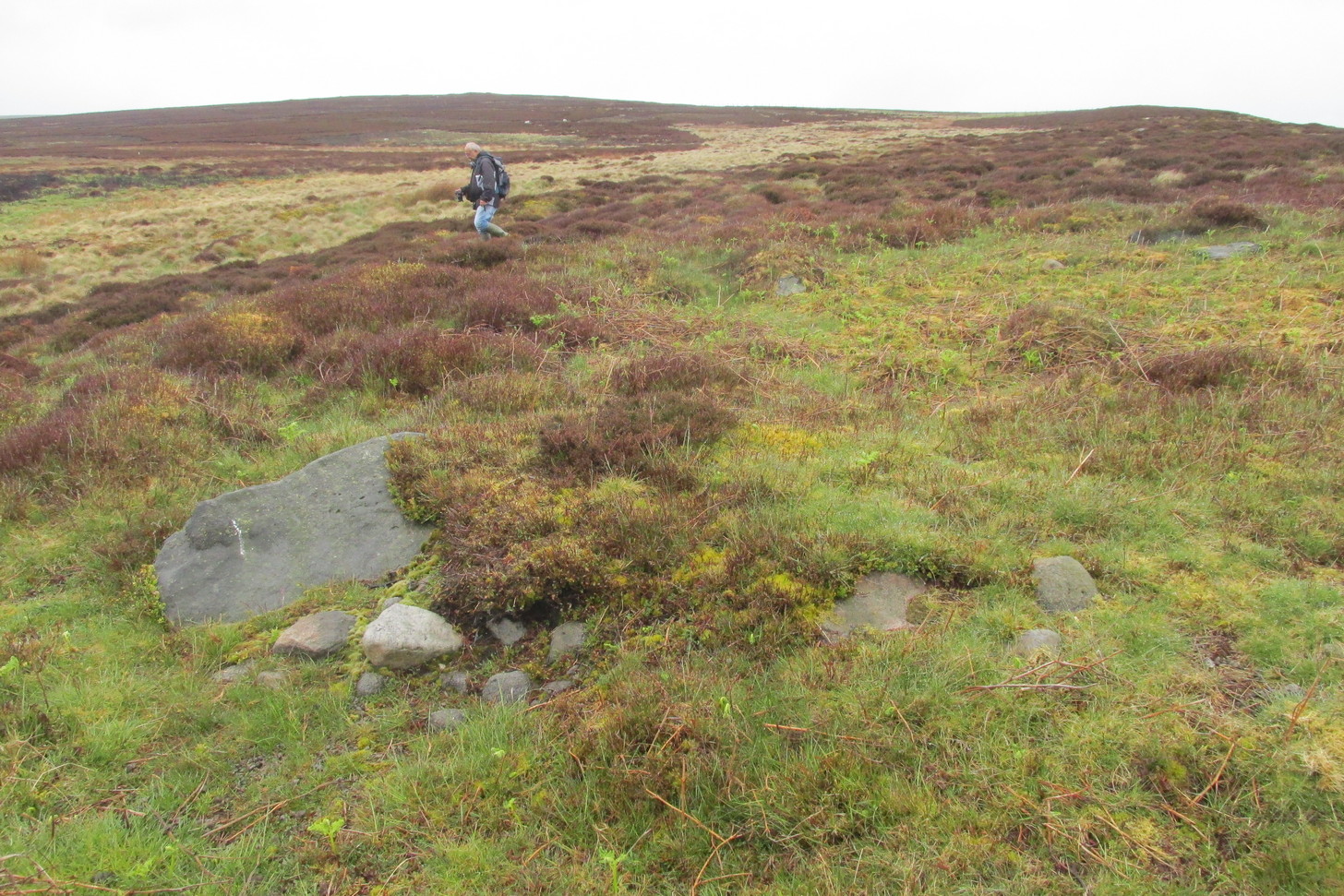
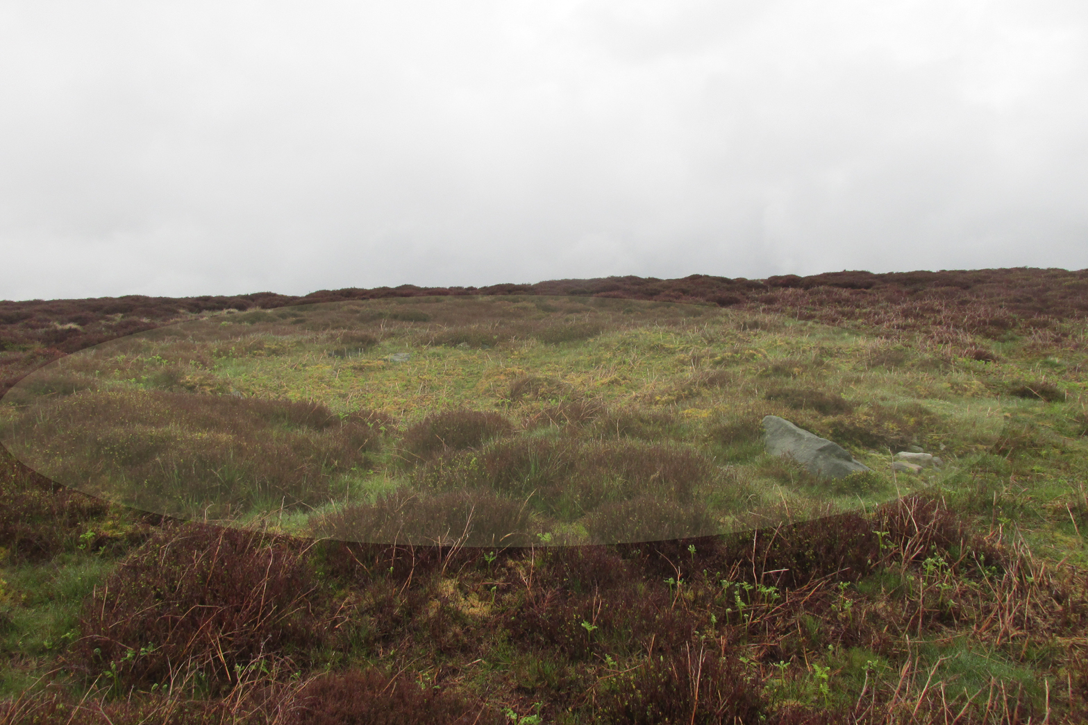
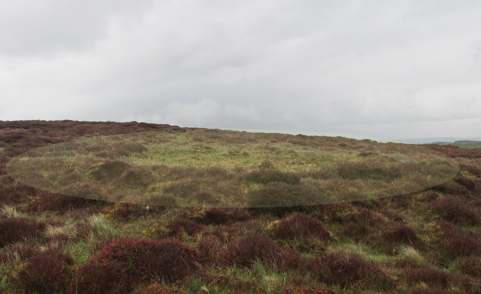
Archaeology & History
Western arc of earth & stone
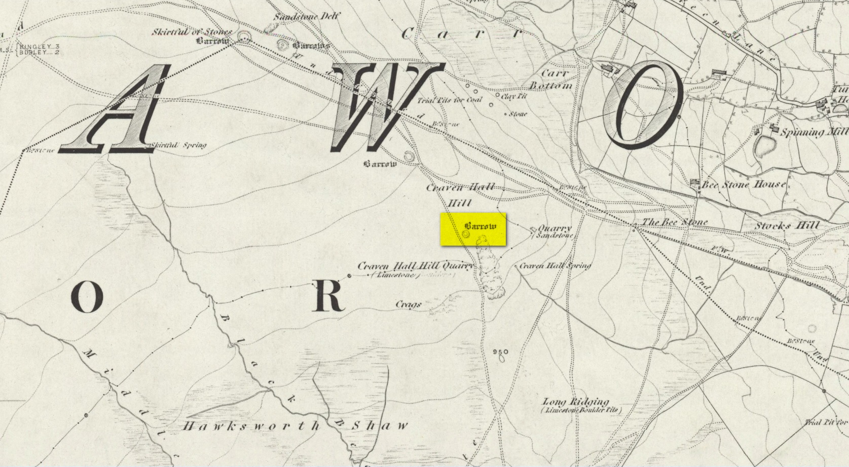
Shown on the 1851 OS-map adjacent to the long prehistoric trackway that runs past Roms Law, the Great Skirtful and other prehistoric sites, the antiquarian wanderings of Forrest & Grainge (1868) came past here and, although didn’t mention the Craven Hall cairns directly, they did write of “a group of barrows” hereabouts, and this may have been one of them. James Wardell (1869) gave an even more fleeting skip, only mentioning “pit dwellings” hereby. A little closer to certainty was the literary attention Collyer & Turner’s (1885) pen gave, where they described, “near the adjoining old trackway, which runs from East to West, will be seen a small barrow”—but this could be either of the Craven Hill sites. And the usually brilliant Harry Speight (1900) gave the place only more brevity….
Structurally similar to Roms Law nearly ¾-mile northwest of here, this little-known and much denuded prehistoric tomb has seen better days. It is barely visible even when the heather’s low—and when we visited recently, the heather was indeed low but, as the photos here indicate, it’s troublesome to see. It’s better, of course, with the naked eye.
Highlighted ring cairn, looking NEHighlighted ring cairn, looking SE
It’s the most easterly cairn in the large Bronze Age necropolis (burial ground) on Hawksworth Moor. Measuring some 12 yards across and roughly circular in form, the ring is comprised mainly of many small stones compacted with peat, creating a raised embankment barely two feet high above the heath and about a yard across on average. A number of larger stones can be seen when you walk around the ring, but they don’t appear to have any uniformity in layout such as found at the more traditional stone circles. However, only an excavation will tell us if there was ever any deliberate positioning of these larger stones. It would also tell us if there was ever a burial or cremation here, but the interior of the ring has been dug out, seemingly a century or two ago…
References:
Collyer, Robert & Turner, J.H., Ilkley: Ancient and Modern, William Walker: Otley 1885.
Faull, M.L. & Moorhouse, S.A. (eds.), West Yorkshire: An Archaeological Guide to AD 1500 – volume 1, WYMCC: Wakefield 1981.
Forrest, C. & Grainge, William, A Ramble on Rumbald’s Moor, among the Rocks, Idols and Altars of the Ancient Druids in the Spring of 1869, H. Kelly: Wakefield 1868.
Speight, Harry, Upper Wharfedale, Elliott Stock: London 1900.
Wardell, James, Historical Notes of Ilkley, Rombald’s Moor, Baildon Common, and other Matters of the British and Roman Periods, Joseph Dodgson: Leeds 1869.