Holy Well (destroyed): OS Grid Reference – NS 6983 4138
Archaeology & History
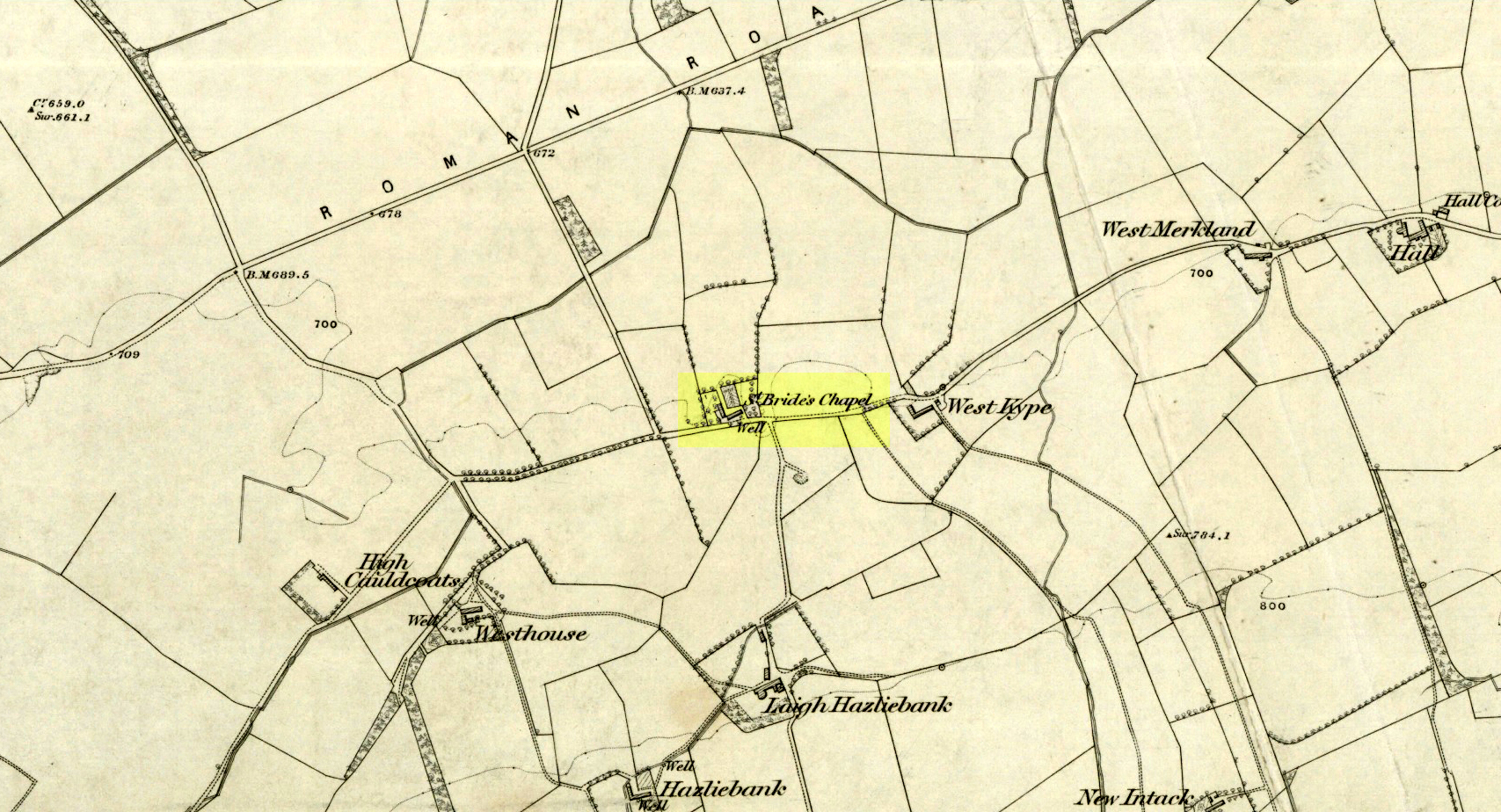
St Brides Chapel & Well on the 1864 OS-map
Shown on the 1864 OS map of the area as a ‘Well’ just at the front of St Bride’s Chapel—now a very pleasant old cottage—peasants and pilgrims would stop for both refreshment and ritual here as they walked down High Kype Road. Although the chapel was described in church records of January 1542 as being on the lands of Little Kype, close to the settlement of St Bride, there seems to be very little known about the history or traditions of the well. If anyone has further information on this site, please let us know.
Folklore
Bride or Brigit has her origins in early British myth and legend, primarily from Scotland and Ireland. Her saint’s day is February 1, or the heathen Imbolc (also known as Candlemas). Although in christian lore St. Bride was born around 450 AD in Ireland and her father a Prince of Ulster, legend tells that her step-father (more probably a teacher) was a druid and her ‘saintly’ abilities as they were later described are simply attributes from this shamanic pantheon. Legends—christian and otherwise—describe Her as the friend of animals; possessor of a magickal cloak; a magickian and a healer; and whose ‘spirit’ or genius loci became attached to ‘sacred sites’ in the natural world, not the christian renunciation of it. St Bride was one of the primal faces of the great prima Mater known as the Cailleach: the greater Gaelic deity of Earth’s natural cycles, whose changing seasons would also alter Her names, faces and clothes, as Her body moved annually through the rhythms of the year. Bride was (and is) ostensibly an ecological deity, with humans intrinsically a part of such a model, not a part from it, in contrast to the flawed judaeo-christian theology.
References:
Paul, J.B. & Thomson, J.M., Registrum Magni Sigilli Regum Scotorum: The Register of the Great Seal of Scotland AD 1513 – 1546, HMGRH: Edinburgh 1883.
Whichever way you come into the hamlet—be it along the A911 from either Milnathort or Glenrothes, or up the B920 from Ballingry side—the only little carpark to use is about 20 yards from the main road junction, on the west-side of the road, appropriately named Well Road. The site is unmissable beneath the small well-house at the end of this short cul-de-sac.
Archaeology & History
When a village is named after a well, you know that its waters held some considerable importance! Mentioned as early as 1218 as “de fonte Scotie” and subsequently many variations thereof in centuries thereafter, the place-names authority Simon Taylor (2017) thinks it may have been mentioned as early as 1090 CE.
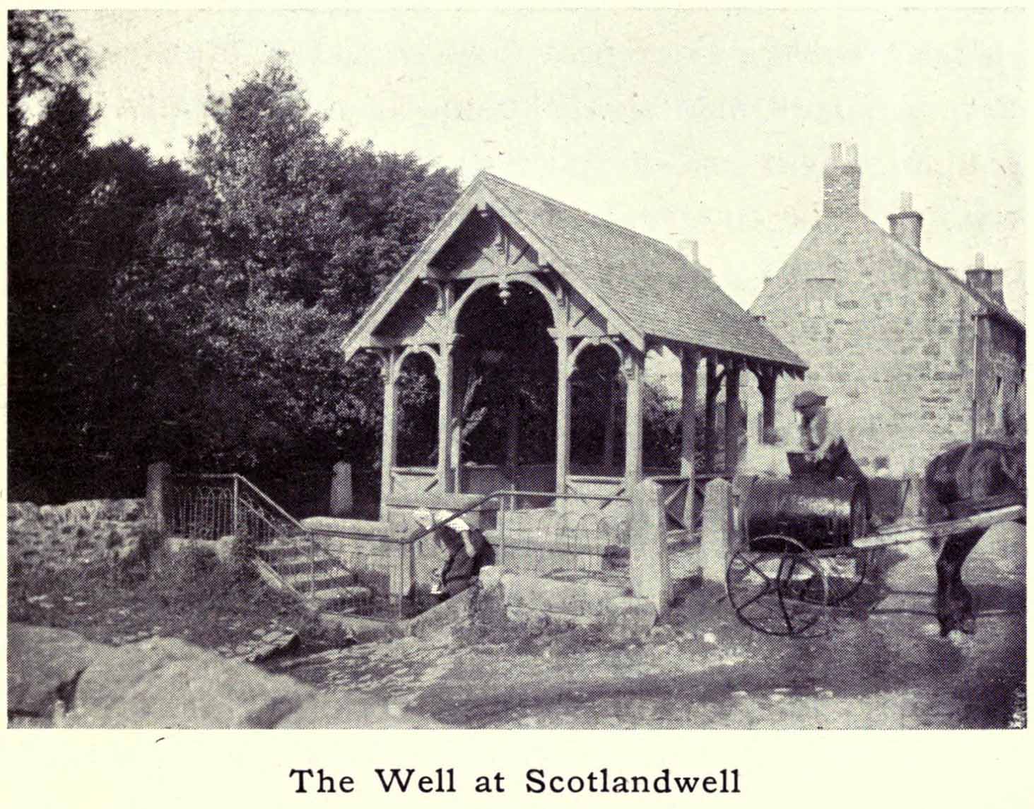
Scotland Well in 1915The clear cold waters
Although there has never been a direction dedication of the Scotland Well to any saint, as J.M. MacKinlay (1904) and others have pointed out, in the village itself was an ancient medieval hospital that belonged to “the Trinity or Red Friars” that was built for the benefit of the poor by the Bishop of St. Andrews, some 22 miles to the east. The hospital was at first dedicated to St. Thomas and subsequently to the Virgin, or St Mary. Holy wells dedicated to both saints are renowned the world over as having great medicinal properties, but no extant written document relates either saint to the well.
Folklore
The main reason for this site maintaining such an honourable place in Scottish history is its association with the two great Scottish heroes, Sir William Wallace and King Robert the Bruce. In the pseudonymous Historica’s (1934) literary rambles, he told that, after coming down out of the Lomond Hills,
“We descend the narrow defile—the Howgate—into Scotlandwell—Fons Scotia—famous for its medicinal springs, where tradition says King Robert the Bruce came to take the waters for scrofula and leprosy in 1295. The great Sir William Wallace—according to ‘Blind Harry’—also has associations here. His famous swim to the Castle Island, for a boat to take over some of his men to capture the english on St. Serf’s, took place from below Scotlandwell.”
In Ruth & Franks Morris’ (1982) fine survey of Scottish wells, they told that upon their visit to the Scotland Well, three people they met still thought highly of its curative properties. “Of these three people,” they said,
“one was a sufferer from cancer which was the cause of a painful skin rash. He had been persuaded to try the water and found that it did him so much good that he was driven from Edinburgh to the well, a round trip of some 80 miles, at at regular intervals to drink the water and take back with him two demi-johns of it.”
According to the man concerned, it did him the world of good and cleared the stubborn body rash he’d been suffering!
References:
Day, J.P., Clackmannan and Kinross, Cambridge University Press 1915.
Historicus, Historic Scenes within our Limits, Kinross-shire Advertiser: Kinross 1934.
MacKinlay, James M., Influence of the Pre-Reformation Church on Scottish Place-Names, William Blackwood: Edinburgh 1904.
Morris, Frank & Ruth, Scottish Healing Wells, Alethea: Sandy 1982.
Taylor, Simon, The Place-Names of Kinross-shire, Shaun Tyas: Donington 2017.
Acknowledgements: Big thanks for being able to use the 1st edition OS-map for this site profile, Reproduced with the kind permission of the National Library of Scotland.
Holy Well (destroyed): OS Grid Reference – T 2481 8173
Archaeology & History
Highlighted on the 1838 OS-map, Grogan and Kilfeather (1997) report that there are “no visible remains” to be seen of this holy well. The cult of St Patrick is still celebrated in Ireland every year on 17 March.
References:
Grogan, Eion & Kilfeather, Annaba, Archaeological Inventory of County Wicklow, Stationery Office: Dublin 1997.
Lynch, Geraldine, “The Holy Wells of County Wicklow,” in Wicklow History and Society (edited by K. Hannigan & W. Noland), Dublin 1994.
This long lost ‘holy well of St Brigit’ (Tobar Bhride) has been mentioned—purely in literary repetition—by such folklore giants as F.M. MacNeill and others, but none of them give any additional information about it than that first mentioned by Alexander Stewart’s (1890) in his fascinating article on magical stones. Indeed, knowledge of this well’s very existence was only preserved thanks to a ritual incantation that was recited to imbue and maintain healing properties of one such magickal stone, known as the Charm Stone of Keppoch. It
“was an oval of rock crystal, about the size of a small egg, fixed in a bird’s claw of silver, and with a silver chain attached, by which it was suspended when about to be dipped.”
It was dipped in water taken from the sacred well of St Brigit, somewhere not far from Keppoch. The incantation made over the stone was in Gaelic, obviously, but the english translation is:
“Let me dip thee in the water,
Thou yellow, beautiful gem of Power!
In water of purest wave,
Which (saint) Bridget didn’t permit to be contaminated.
In the name of the Apostles twelve,
In the name of Mary, virgin of virtues,
And in the name of the high trinity
And all the shining angels,
A blessing on the gem,
A blessing on the water, and
A healing of bodily ailments to each suffering creature.”
On the east side of the river, just a few hundred yards away, could once be found the Fuaran na Ban-Tighearna, or the Well of Her Ladyship. In this sense, the term ‘ladyship’ refers to the “wife of a baronet or knight.” (Dwelly 1918) The idea that it may refer to Bride in Her guise as a ‘lady’ is linguistically improbable here (though not impossible). Also, if this fuaran did have a geomythic relationship with Bride, we would expect to find a Cailleach in the nearby landscape, which we don’t.
Folklore
An interesting piece of folklore that may relate to this well is described by the great Scottish landscape wanderer, Seton Gordon. (1948) Although he makes no mention of a Bride’s Well, there is the tale of a missing bride up Glen Roy, of which Keppoch sits below. “It was in earlier times,” he wrote,
“that the Maid of Keppoch was taken by the fairies in Glen Roy. She was an Irish girl, little more than a child, and had become the wife of MacDonell of Keppoch. But the wedding rejoicings were scarcely over when the bride, wandering into the oak woods which still clothe the lower slopes of Glen Roy, disappeared mysteriously. It was believed that, like the Rev Robert Kirk…she had been spirited away by the fairies. If indeed she was abducted by the Little People they held her closely, for from that day to this no trace has been found of the fair Maid of Keppoch.”
St Bride of course was Irish, like the Maid of Keppoch. And just a mile up Glen Roy from Keppoch House we find the Sron Dubh and Sithean, or Ridge of the Dark Fairy Folk. There are several burns (streams) running either side and below this fairy haunt, but I can find none with Bride’s name. Someone, somewhere, must know where it is…
References:
Gordon, Seton, Highways and Byways in the Central Highlands, MacMillan: London 1948.
Dwelly, Edward, The Illustrated Gaelic English Dictionary – volume 1, Fleet Hants 1918.
Stewart, Alexander, “Notice of a Highland Charm-Stone,” in Proceedings Society Antiquaries, Scotland, volume 24, 1890.
Ladywell Lane is shown on the 1855 OS-map (right).
At present we have no information or images about this site. Be the first person to contribute material by emailing us with info or images to the usual address – megalithix@yandex.com
At present we have no information or images about this site. Be the first person to contribute material by emailing us with info, field notes or photos to the usual address – megalithix@yandex.com
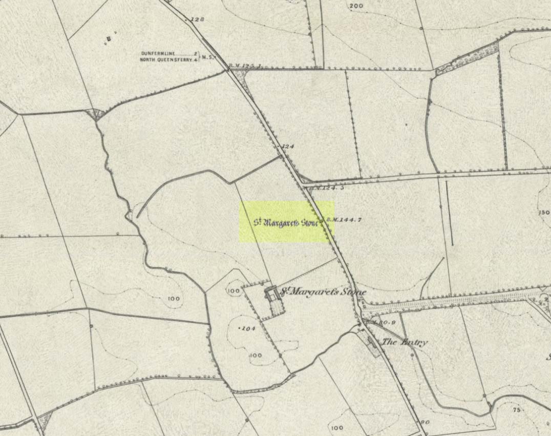
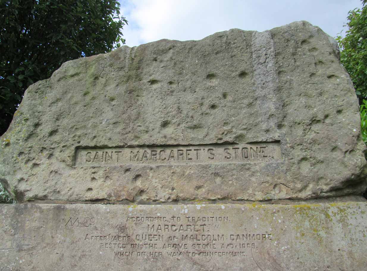
Take the A823 road out of Dunfermline south towards Rosyth. A half-mile before you hit the motorway roundabout, at the roundabout where Carnegie Avenue takes you east, turn west and park up along the road where the modern business park lives. 30-40 yards from the roundabout, set back on the pavement, you can’t really miss the huge flat slab of stone, covered in cup-markings, resting on a stone plinth with ‘St Margaret’s Stone’ stamped on it!
Archaeology & History
On the 1856 OS-map of this area, St Margaret’s Stone is shown at the roadside just above a farm of the same name, a short distance away from its present location. In October 1879, Alexander Stewart (1889) told us that funds were raised and steps taken to properly fix and preserve this ancient ‘resting-place’ of Queen Margaret on the Queensferry Road. It was quite a few years later before it was moved the few hundred yards further to its present location.
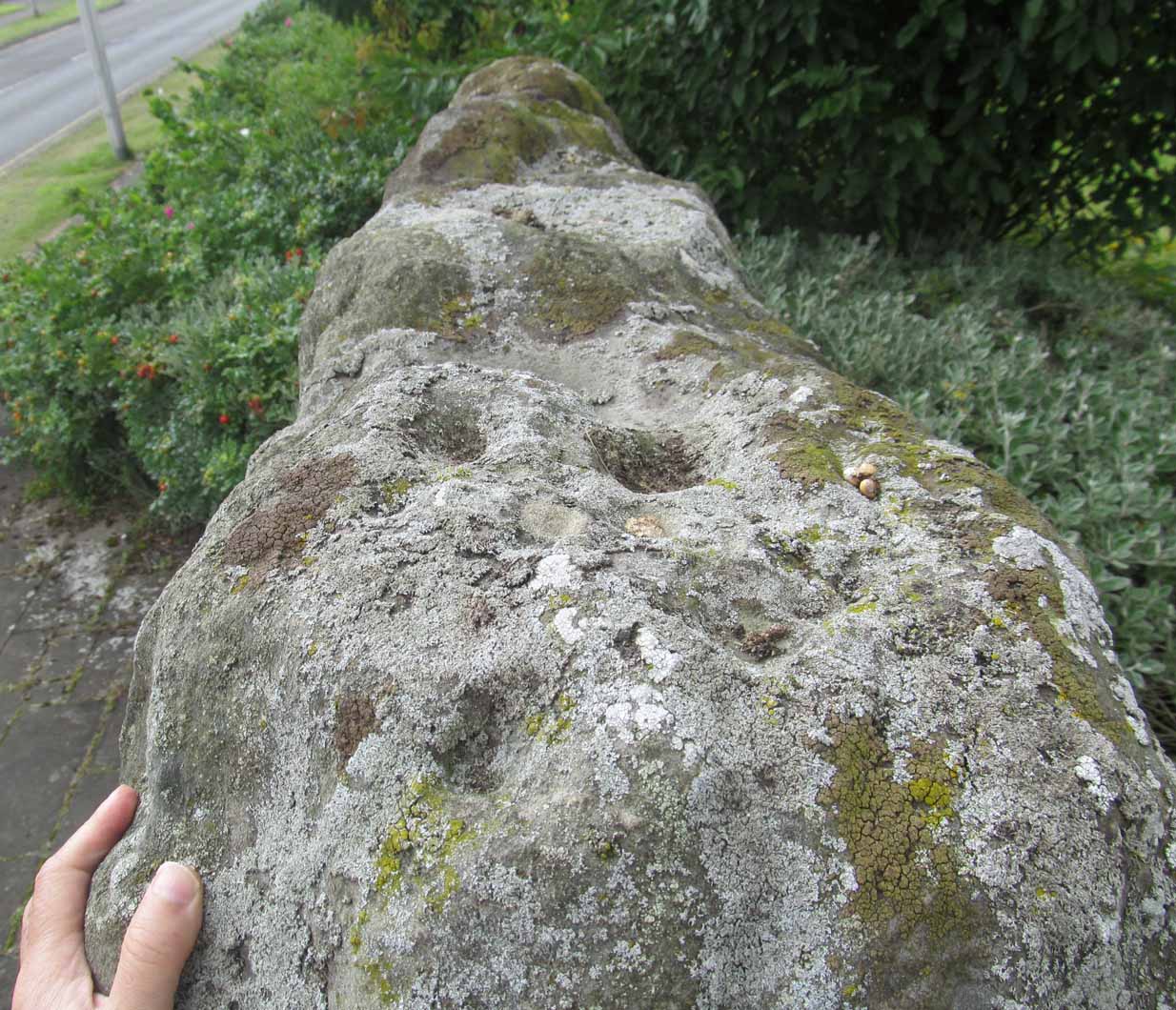
Cups on stone’s edge
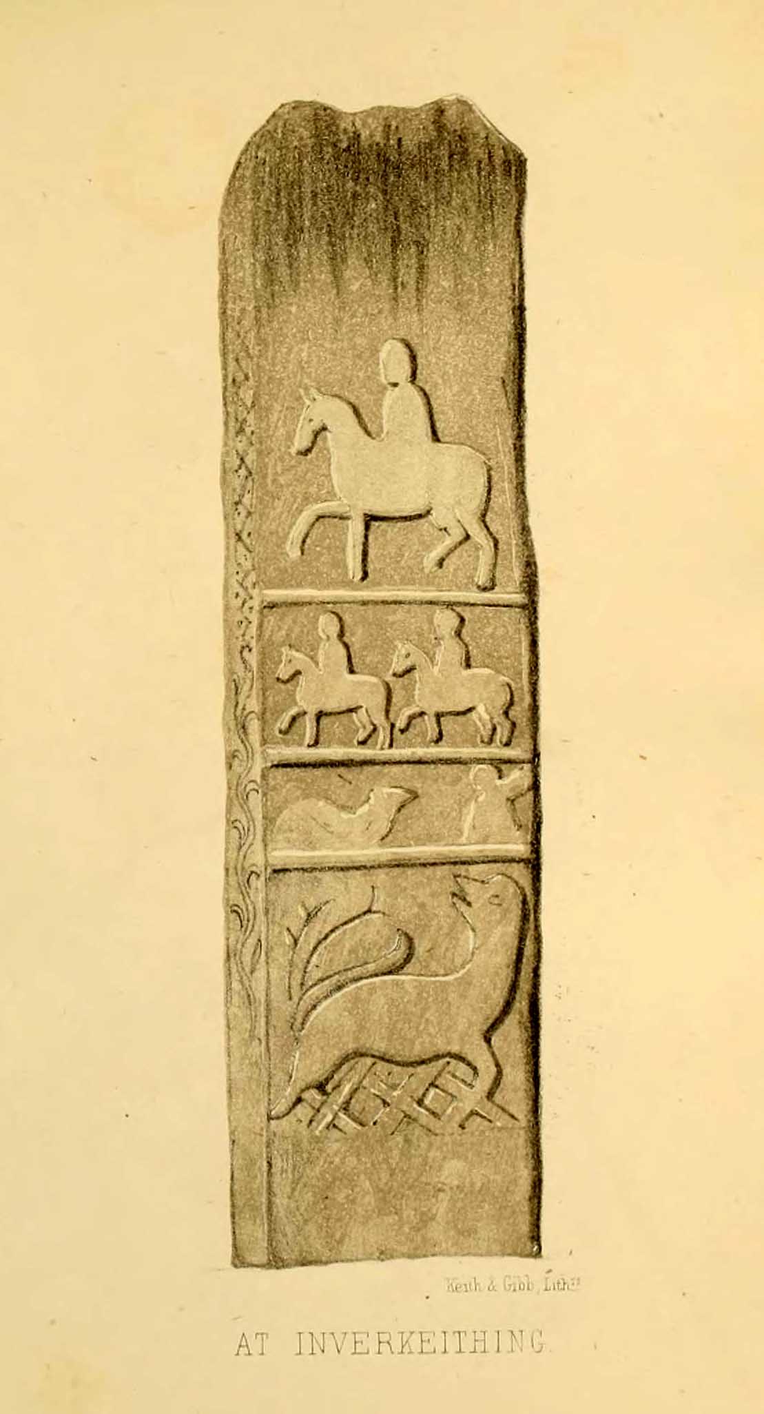
Early writers tell us that originally its position in the landscape was on the crest of one of the rises in the land between Dunfermline and the sea, making it visible for some considerable distance. This would seem to have been a deliberate placement. In my mind, and in accordance with the placement of many a prehistoric tomb, St Margaret’s Stone may originally have been part of a neolithic or Bronze age cairn, long since gone. The size and shape of the rock implies it too, with similarities here of the impressive cist or gravestone found inside the Netherlargie North cairn at Kilmartin. However, this wasn’t the thought of the prodigious Scottish historian, William Skene. He thought that St Margaret’s Stone originally stood upright, being a Pictish-style standing stone that was mentioned in the first Statistical Account of the area. The brilliant Scottish antiquarian, John Stuart (1856)—who gave us an illustration of the ‘standing stone’ in question—told us:
“It has been supposed by some that “St. Margaret’s Stone,” a block now lying on the side of the highway leading from Inverkeithing to Dunfermline, and about midway between these places, can be identified with the standing stone referred to in the Statistical Account. Mr Skene has noted below a sketch of St. Margaret’s Stone:- “The sculpture upon this stone has been lately chipped off in mere wantonness, so as to leave few traces of the subject recorded upon it.” He farther states that it formerly stood erect, and was called “The Standing Stone.” According to Mr. Skene’s measurement, St. Margaret’s stone is about nine feet and a half in length, one foot in thickness, and four feet broad at the widest end, and broken off to a narrow point at the other.”
The missing ‘standing stone’
In this instance, Skene was confusing St Margaret’s Stone with the lost Pictish monolith (left) that used to exist nearby, which had carved horse figures and other memorial designs upon it and which he thought had faded away. Whereas the large slab we are looking at here, and which Skene visited and measured, is covered on one side by a gathering of prehistoric cup-markings—much earlier than any Pictish or early christian carvings. At first glance, it seems that some of these cups may well be natural, but it has to be said that some of them are distinctly man-made. And if we were to believe the archaeo-accounts of the stone, the cupmarks are only to found on one side of the stone. This is incorrect. As we can see here, a number of cupmarks run along the edge of the stone. We cannot say for sure whether all of them are artificial, but they certainly look like it! Also, on the other side of the flat surface, one or two single cups are visible. It would be good if we could get an artist to give us a detailed impression of the prehistoric carvings without the modern engraving of St Margaret’s Stone etching on the main face. (is there anybody out there!?)
The Royal Commission (1933) lads visited the stone in 1925 and, several years later in their write-up, told us simply:
“This stone…stands with its main axis due north and south and measures 8 feet 6 inches, by 4 feet 7 inches, by 1 foot 6 inches. On one side the entire surface is cup-marked, the markings varying in size from 1¼ inches to 3¼ inches and having an average depth of from ½ to ¾ inch.”
When the Scottish petroglyph writer and explorer, Ron Morris (1968) came to the site, he gave it an equally brief description, merely telling us:
“On standing stone (8 1/2 feet high, 4 1/2 feet wide), built in to roadside fence, over 80 cups, up to 4in in diam, 3/4in deep, some run together as rough dumbells.”
It’s well worth checking out!
Folklore
St Margarets Stone in 1825
When the Saxon Queen Margaret landed on the shores just west of Queensferry at Rosyth Castle (NT 1087 8200), legend reputes that she and her entourage made Her way north towards Dunfermline. Halfway along the ancient track She rested at this large stone which, thereafter, gained the name by which we know it today. It was said that Queen Margaret subsequently visited the stone on a regular basis for periods of solitude. The tale probably has some germ of true in it. Additional ingredients also told that,
“The large stone here is associated with St Margaret and was visited by women who hoped to conceive or sought a successful birth. The eight-foot high stone is said to mark the resting place of St Margaret when she journeyed between Queensferry and Dunfermline. Margaret had eight successful pregnancies and probably needed to rest quite a few times on her travels!”
The fertility aspects of the rock were not the only pre-christian virtues attached to it. We also find that oft-cited motif of rocks moving of their own accord: in this case, as J.B. MacKie (1905) told us, local people had always
“been told that the stone rose from its bed and whirled thrice round in the air every time it heard the cock at the adjoining farm crow.”
Cocks crowing are symbolic of sunrise, obviously, and this lore may simply represent a folk memory of the spirit in/of the stone being animated at that time of day. It’s a motif found at ancient sites all over the place!
Royal Commission Ancient & Historical Monuments of Scotland, Inventory of Monuments and Constructions in the Counties of Fife, Kinross, and Clackmannan. HMSO: Edinburgh 1933.
Rupert-Jone, John A., Rosyth, A. Romanes: Dunfermline 1917.
Stewart, Alexander, Reminiscences of Dunfermline and Neighbourhood, Scott Ferguson: Edinburgh 1889.
Healing Well (destroyed): OS Grid Reference – SE 22 33
Archaeology & History
Ths curiously-named site is described just once in very early field-name records as the ‘Fukewell’. Included in A.H. Smith’s (1961) magnum opus, he passes over the place-name without comment. But in finding his 12th century literary source, we read that it was located on some land given to the monks of Kirkstall Abbey, Leeds. Written in early disjointed Latin, we find that the Fukewell was mentioned on a grant that described five acres of land given by one Adam Samson to the monks of the Abbey. On one of the acres was a site known as the Cold Well, whilst the Fuke Well was found on a piece of land adjacent to a house, but its precise location seems to have been lost. Nothing is mentioned about it by great Pudsey historan Simeon Raynor, despite him naming a number of other wells in the area – so we must presume that the site had already gone when he came to write his work.
But what does the word fuke actually mean? There is nothing to explain it in Wright’s Dialect Dictionary, nor other regional dialect or place-name works. I was wondering if it derived from the old english word ‘fuck’, which was common parlance in earlier centuries. ‘Fucking’ was a word that didn’t have the debased christian ideology attached to it: of something not to be talked about, or be hidden. To have a fuck, or go fucking, was always quite normal; and to most people in the real world we use the same term with absolute ease – because we all do it! But this etymological idea is pure speculation on my part. Can anyone give clear light to fuke’s real meaning?
References:
Fryer, Peter, Mrs Grundy, Dennis Dobson: London 1963.
Lancaster, W.T. & Baildon, W. Paley (eds.), The Coucher Book of the Cistercian Abbey of Kirkstall, Thoresby Society: Leeds 1904.
Smith, A.H., The Place-Names of the West Riding of Yorkshire – volume 3, Cambridge University Press 1961.
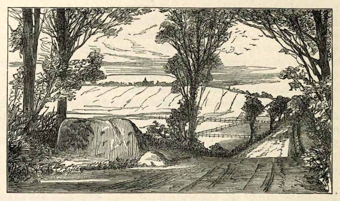
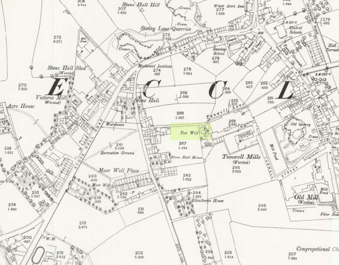
First mentioned in local history accounts from 1618—as the Tunwells—it was highlighted on the first OS-map of Eccleshill in 1851. Located on the aptly-named Tunwell Lane, it was a deep well covered by a large flat slab of stone, at the back-end the old Victorian mill. The stone was put there to prevent children falling into it. Some old locals thought the name of the place derived from a ‘tun’, or hundred, meaning it to be a hundred feet deep; although as A.H. Smith (1961) tells, tun could equally relate it to be one of Eccleshill’s town wells, of which there were several. It used to be one of the principal drinking supplies for the village and was said to rarely run dry. In William Ranger’s (1854) survey, he told this to be one of the sites to which local people relied in times of drought, where the land-owner allowed local folk to collect their supplies.
Folklore
The old cobbled Tunwell Lane was long ago supposed to be the haunt of a phantom black dog: a visionary precursor of death and Underworld guardian. Its spirit came and went into the deep well. I remember hearing tales of this when I was a young lad, as the old women who worked in the adjacent mills spoke of it. The ghost of a so-called ‘white lady’ was also said to walk along Tunwell Lane.
In more recent times, Val Shepherd (2002) included this in her short survey of wells in the area as being on “an alignment” with Eccleshill’s Moor Well and Holy Well. She thought “it may be part of a ley line”, but her alignment is inaccurate and doesn’t hit the spots.
References:
Crapp, H.C. & Whitehead, Thomas, History of the Congregational Church at Eccleshill, Watmoughs: Idle 1938.
Ranger, William, Report to the General Board of Health on a Preliminary Inquiry into the Sewerage, Drainage, and Supply of Water, and the Sanitary Condition of the Inhabitants of the Township of Eccleshill, George Eyre: London 1854.
Shepherd, Val, Holy Wells of West Yorkshire and the Dales, Lepus: Bradford 2002.
Smith, A.H., The Place-Names of the West Riding of Yorkshire – volume 3, Cambridge University Press 1961.
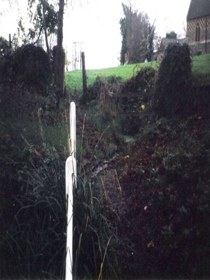
Hadstock lies along the A1052 north of Saffron Walden. Once in the village, a fenced pond will be apparent on the left below the church. Just above the pond is the well that feeds it – yet there seems some confusion regarding the exact location of the site.
Archaeology & History
John Wilson in his Imperial Gazetteer, III (1872) describes it as:
“A well set round with stones, and called St. Botolph’s Well, is in the churchyard.”
However, by the time of An Inventory of the Historical Monuments in Essex, I (1916) it was:
“In the churchyard—a well, known as St. Botolph’s well, now covered.”
St Botolph’s Well
Indeed there would be some confusion regarding the exact location of this well. The church guide describes a pump to the west end of the churchyard as the well (but the only pump apparent was that across the road), however I was informed that this well was the one picturesquely situated by the road beneath the church. This is a brick-lined square well whose spring percolates into a pool covered in duckweed. No evidence of any material earlier than Victorian is apparent, suggesting it may date from when the pump was established. A wooden fence has been erected around it to prevent people falling in, but apparently the well itself has been covered.
Folklore
The village has a St. Botolph’s Well although there is no direct link recorded between it and the saint of that name, but local tradition believes that he was interred in this church. This view was supported by the discovery of an empty Saxon grave in the east wall of the South Transept. Greater credence being lent by the fact that this had previously been exhumed, which is in accordance with the knowledge that the relics were removed in 970, and then distributed around East Anglia.
Its waters have had a mixed reputation. Tradition records their ability to cure scrofula. Until recently the well was the important source of drinking water for the village. One tradition suggests that if a ring was dropped into it by a lovelorn girl she would find her true love. This tradition was supported by the finding of two rings recently in the cleaning of the well. Wilson (1970) notes a strange activity was practiced within living memory by the white witch: to keep the water pure, dead cats were placed down the well. Obviously, this was not continued for on one occasion the water was the harbinger of a typhoid outbreak, and forty percent of the population—or 40 people—died (although there is no evidence for either). The contamination was the result of the Rev F. E. Smith using the spring as an outlet for his lavatory. If this was not bad enough, one of his staff was a typhoid carrier! This is also notwithstanding, that it was commonly believed that the spring water drains from the graveyard above it: and hence it has earned the name ‘bone gravy’. Despite all these traditions, this did not deter the locals, who vouched for its goodness. Even when piped water was brought to the village in the 1930s, many locals could not see the point as the well water was good enough.
References:
Parish, R.B., Holy Wells and Healing Springs of Essex, Pixy Led Publications 2008.