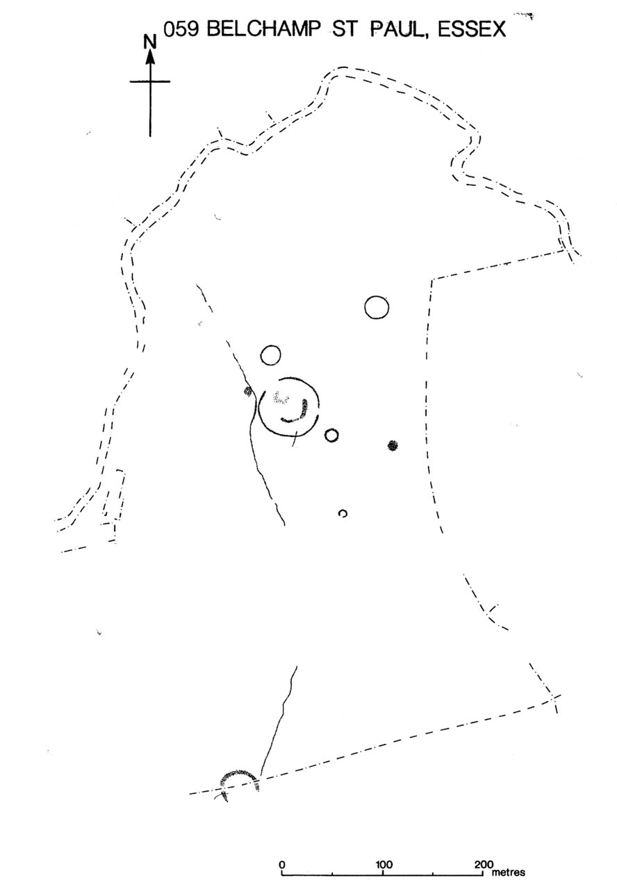
Several hundred yards northeast from Hickford Hill, a cluster of prehistoric sites could once be seen close to each other just south of the River Stour below line of the Essex-Suffolk county boundary. Several of these were tombs and are accounted for in Priddy’s (1981) essay on the prehistoric Barrows of Essex; but adjacent to them were also found faint traces of a large circular enclosure of some sort, which Harding & Lee (1987) included in their definitive survey of British henge monuments. Their account of it was brief and simple, saying:
“Enclosure defined by the cropmark of a sub-circular rather narrow ditch broken by two entrances. No trace of a bank. Internal traces of a concentric innner ditch in part of the circuit… Internal diameter range 56-57m…; width of outer ditch c.1.5-2.5m; width of entrances, c.7m (E) and 16m (NW); width of inner ditch c.2.5-5m.”
Although this large ringed enclosure was thought by the Haverhill & District Archaeology Group to “be a henge-type monument,” Harding & Lee (1987) thought it unlikely that these remains “belong to the henge class” of monuments. A brief archaeological dig into one of the trenches here in 1997 showed the site to be Bronze Age; but finds by the local archaeology team have also come across finds in the fields hereby dating from the Mesolithic and Neolithic periods.
References:
Harding, A.F. & Lee, G.E., Henge Monuments and Related Sites of Great Britain, BAR 175: Oxford 1987.
Priddy, D., “The Barrows of Essex,” in A.J. Lawson’s The Barrows of East Anglia, Norfolk Museums Service 1981.
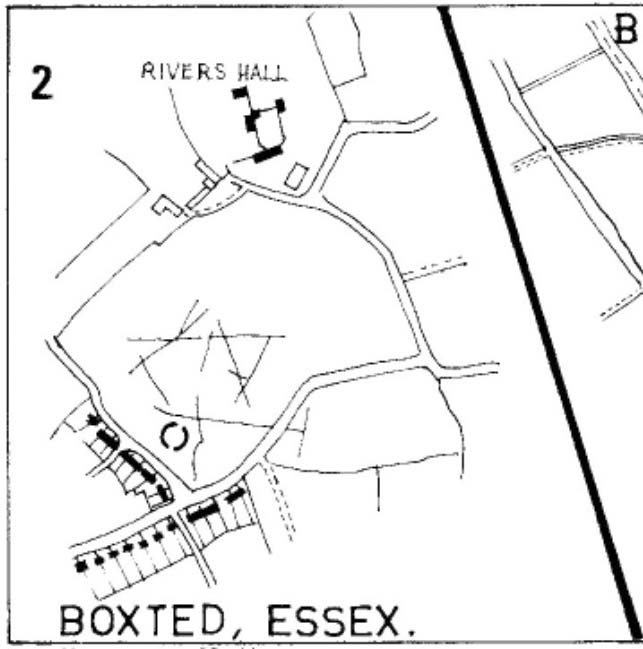
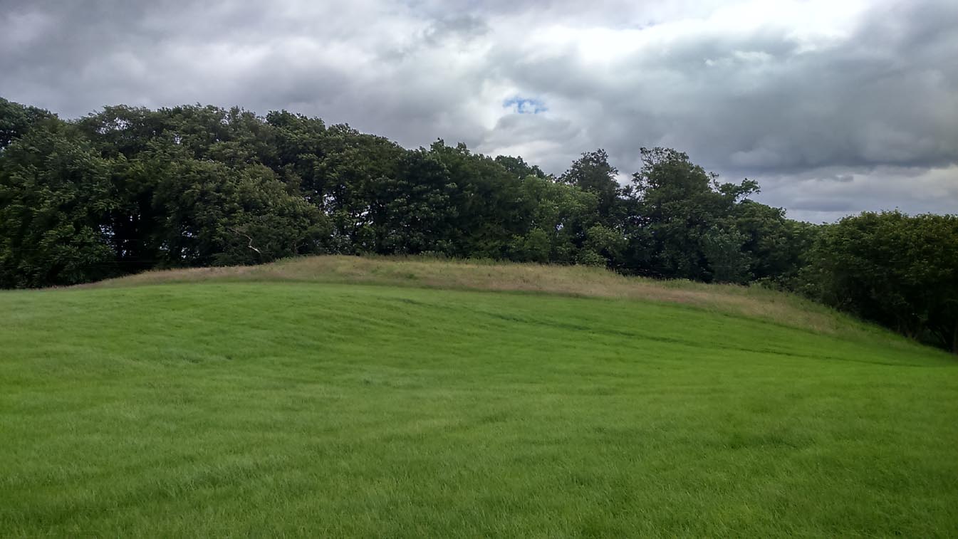
As with many sites in Southern England, intensive agriculture has taken its toll on the archaic monuments. The Boxted Cross henge is no exception and hardly any elements of it remains today. But it seems that it was an impressive fella in our more ancient heathen past.
The site was only rediscovered in the 1970s and was first described in Mrs Ida McMaster’s (1975) survey of crop-marks that had been revealed by aerial surveying in Essex and Suffolk counties. Her brief account of the monument told it to be,
“A Class II henge with a wide somewhat ploughed out ditch. Various linear ditches are near, together with prolific variegated ‘field outlines’ of glacial subsoil cracking which extends into the next field southwards. The ditch terminals of the southwest entrance to the henge appear to be wider than the general run of the ditch, say 4-5 metres.”
When Harding & Lee (1987) examined the site, they were a little more cautious in their interpretation of it being a definite henge, citing that there was “insufficient information, but cannot be ruled out as henge-related,” adding that it “could also be a mill.” This latter element seems unlikely, though a windmill may have been built onto the site at a later date.
More recently however the site has been categorized by Historic England as “a Late Neolithic henge.” The monument itself was defined by a broad circular ditch with two large opposing entrances to the north and south. The total diameter of the enclosure is 44 yards (40m) across; but with the surrounding ditch measuring 5½ yards (5m) across all around, the inner level of the henge was about 33 yards (30m) in diameter. Plenty of room for partying old-style!
References:
Harding, A.F. & Lee, G.E., Henge Monuments and Related Sites of Great Britain, BAR 175: Oxford 1987.
This much disturbed Iron Age ‘hillfort’ is effectively a large enclosure of Iron Age origin, much ruined by farming and subsequent landscape alterations through the centuries, with much of it re-fashioned as a medieval moat more than a thousand years after first being built. Even when the site was visited and described in Mr Wadmore’s (1920) fascinating work he told of the variants in its apparent construction phases:
“This large earthwork is situated on flat level ground, a few yards off the Bedford-Kimbolton Road, at the VIIth milestone out of Bedford. In shape it is very irregular and presents little to aid one in arriving at an estimate of its original form, except the construction of its defensive lines, which are of two totally different characters and suggest that a comparatively modern manor has been added to an older work.
“The portion which I take to be the older, lies to the south, and is contained on this and the western side, as far as and including the great sweep bending east, by a strong vallum with a parapet and external fosse.
“The modern portion appears to me to commence between the east and west faces where the lines run north, and are purely the remains of a fosse without any indication of a parapet. The extension of these lines, so far as can be traced, would tend to prove that the work occupied both sides of the road; but such a fact should not prejudice one’s view concerning the work as a whole….”
Section of the earthworks drawn by Wadmore
Adding with a good sense of humility that, “I am quite willing to admit that I may be mistaken, as the matter is entirely speculative.” But modern archaeological analysis tends to prove that much of Wadmore’s words were correct and the remaining northern section of these earthworks is where the medieval moated section was built. Roman remains and other period artifacts have also been unearthed in and around the site.
A few hundred yards southwest of the hillfort we find a place called Greenbury Farm. This place was known in the 14th century as ‘Grymesbury’, which has been taken by some students as relating to the Norse deity, Grim. However, Mawer & Stenton (1926) point out that in this instance,
“The Grym family had a holding in Bolnhurst in 1302 and bury is here used in the manorial sense. Hence ‘Grym’s Manor.’”
References:
Mawer, A. & Stenton, F.M., The Place-Names of Bedfordshire and Huntingdonshire, Cambridge University Press 1926.
Wadmore, Beauchamp, The Earthworks of Bedfordshire, Bedfordshire Standard: Bedford 1920.
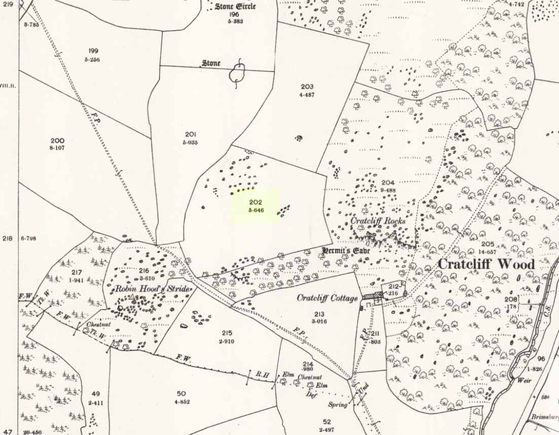
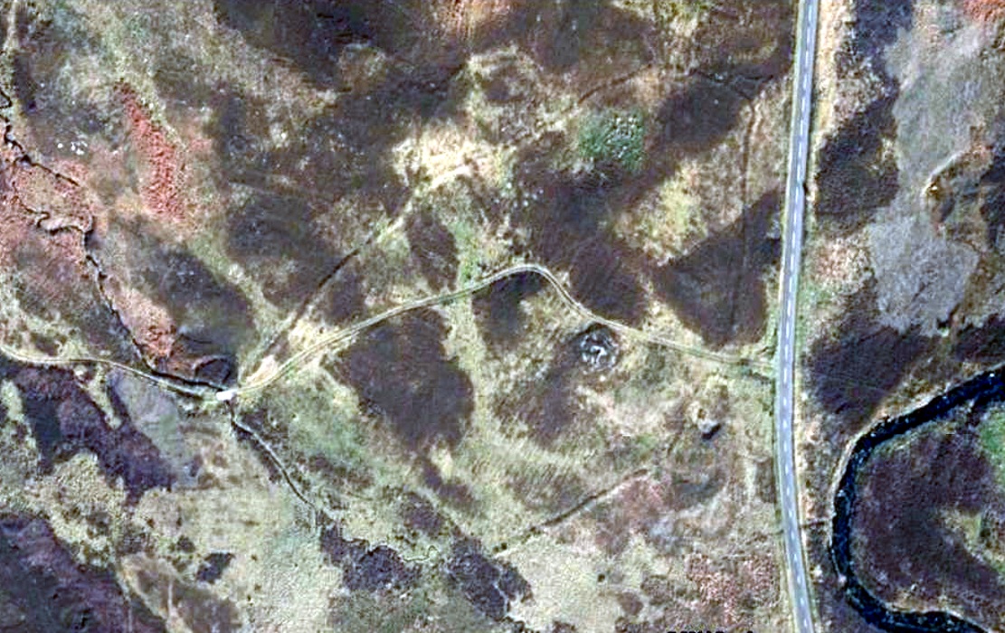
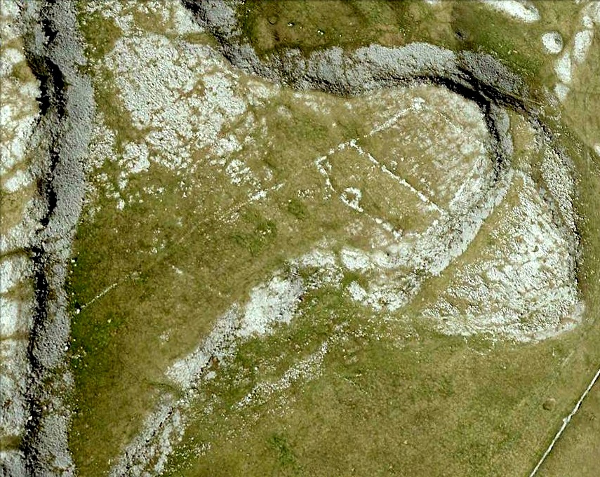
Taking the roughly north-south road betwixt the village of Elton and the town of Youlgreave, rising up to see the great rock outcrop of Robin Hood’s Stride, park-up by the roadside and walk down the path towards the impressive rocky rise of Robin Hood’s Stride. Keep to the fields below the Rise on its north side and head for the next wooded rise 2-300 yards west. In the field you’ll cross (field number 202 in on the map, right) before this wooded crag [Cratcliffe Rocks], the outline of the enclosure is beneath your very feet.
Archaeology & History
Aerial image of the Ninestone Ring enclosure
This blatantly obvious oval-shaped enclosure or settlement ring has had very little said of it in archaeological circles as far as I can tell. (please correct me if it has!) I found it quite fortuitously during aerial surveys of the nearby Nine Stones circle. It’s certainly quite large. With a general circumference of roughly 285 yards (260.5m), the relative diameters of this enclosure are—from north to south—91 yards (83m) and—east to west—80 yards (73.25m). The ditch alone is quite wide all the way around, almost giving it a ‘henge’ quality. Its southern section is nearly 10 yards across at one point!
The northwest section of the enclosure has been built into, or upon a small natural outcrop of rocks. But also at this point—as seen clearly in the aerial photo—on the other side of the wall just past the raised natural outcrop, is a long straight parallel linear feature, very probably man-made, running away to the northwest for at least 174 yards (159m). It too is quite large, averaging more than 13 yards (12m) across all along the length of this “trackway”: twice as wide as the nearest road and similar in form to the smaller cursus monuments that scattered neolithic Britain.
The site seems to be typical in form and structure to general Iron Age, or perhaps late Bronze Age settlements – but without a proper ground appraisal, this is a purely speculative appraisal. Any further information or images of this site to enable a clearer picture of its nature would be most welcome.
Acknowledgements: With thanks in various way to Pete Woolf, Dave Williams, Geoff Watson & Martin Burroughs.
Take the Gateside Road from St Ninians or Polmaise Road out of Torbrex across the M9, heading out west onto the southern moors of Touch Hills, passing the Wallstale dun in the trees and then the Castlehill dun just off the road. Keep going uphill for just over half-a-mile, keeping your eyes peeled on the right for where the MOD lads play some of their war-games. Walk along the track here, following the line of the woods, until it gets to the spot where it doubles back on itself. Just here, about 30 yards in front of you, a rounded walled knoll gives the game away!
Archaeology & History
Artists impression of the reconstructed site (PSAS 1959)
An impressive-looking site, not too far off the moorland road, it is one of more than half a dozen hillforts and duns found to the west of Stirling, all of them relatively close to each other—showing that a lot of human activity was going on here in the Iron Age and, probably, much earlier. Looking like a cross between a broch and a traditional hillfort, the site is best visited in the Winter and Spring months before the bracken starts to encroach and cover it.
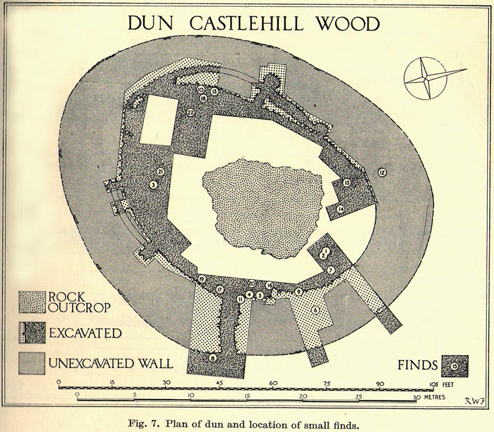
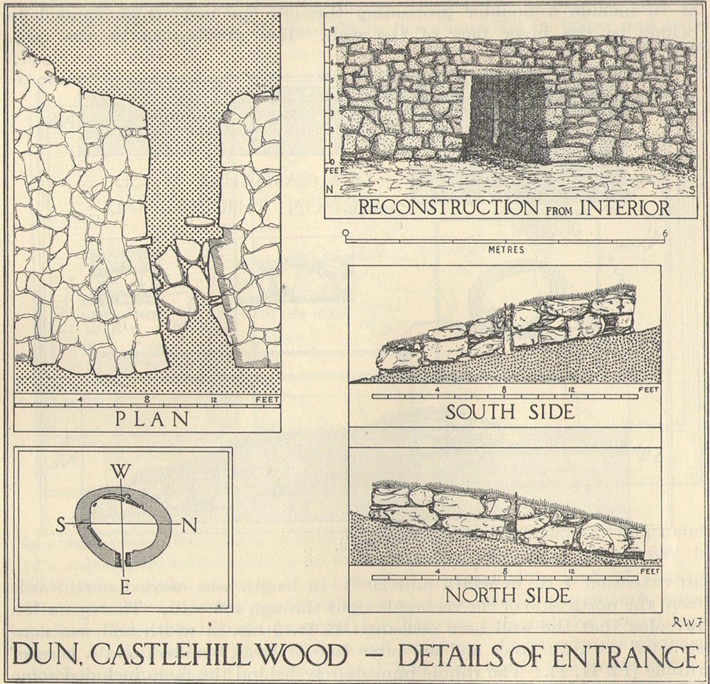
Officially rediscovered in 1952 and excavated three years later, it was thought to have been built in the 1st century AD and used for a few hundred years thereafter. As you walk up to the eastern edge of the monument, a large entrance, 4½ feet wide, allows you into the large open space within. From here, and walking around both the inner and outer walls, you get an idea of the huge amount of work it must have taken to build this structure. The walls alone which constitute the main of Castlewood Dun are, on average, 16 feet thick! The Royal Commission report for the area (summarizing the archaeological work of F.W. Feacham in the ’50s) gives the basic architectural features of the place:
“The dun is oval in plan…and measures 75ft from NE to SW, transversely within a drystone wall 16ft thick. The faces of the wall are composed of large, angular blocks, and the core of boulders, small rubble and earth. The entrance in the E arc, is provided with door-checks. Within these, the passage measures 4ft 6in in width, and outside them 3ft 9in. A few paving-stones were laid to level the rough rock surface of the passage-floor. Traces of what might have been the bottom step of a stair, rising up the inner face of the wall, were found at a point 8ft N of the entrance. The dun had no mural stair or galleries, but two sets of mural chambers were located, one in the W and the other in the S acr of the wall. The former consisted of an entrance-passage, 6ft in length, which varied in width from 2ft at the outer to 3ft at the inner end, where it opened into a circular chamber 4ft in diameter. From either side of the passage a narrow duct or flue, about 19ft in length and 1ft 6in in width, led off obliquely through the core of the wall to debouch into the interior of the dun. The construction in the S arc consisted of a similar passage, one flue and a smaller chamber. Ash and a clinker of very light weight were found in the form of deposits in both passages and all the flues. …The excavator suggested they might have been corn-drying installations.”
Groundplan of site (PSAS 1959)Entrance details (PSAS 1959)
Apart from a small piece of Roman glass, quern fragments, anvils stones and a pot lid, the excavators found very little inside the dun—not even any hearths. The walling on the southwest and western edges was built onto a small cliff, making access slightly difficult from that side.
From the site itself, views are excellent, particularly in an arc through the north, east and southeast, with the western skylines being only a short distance away. This enabled relatively easy tribal communication with people at the other brochs, duns and forts in the area, across an otherwise large but difficult landscape in prehistoric times. A few hundred yards to the northeast, on the other side of the recently planted tree-farm (forestry plantation), a large D-shaped structure—possibly Iron Age, possibly medieval— is accompanied by lines of ancient walling running down the slopes.
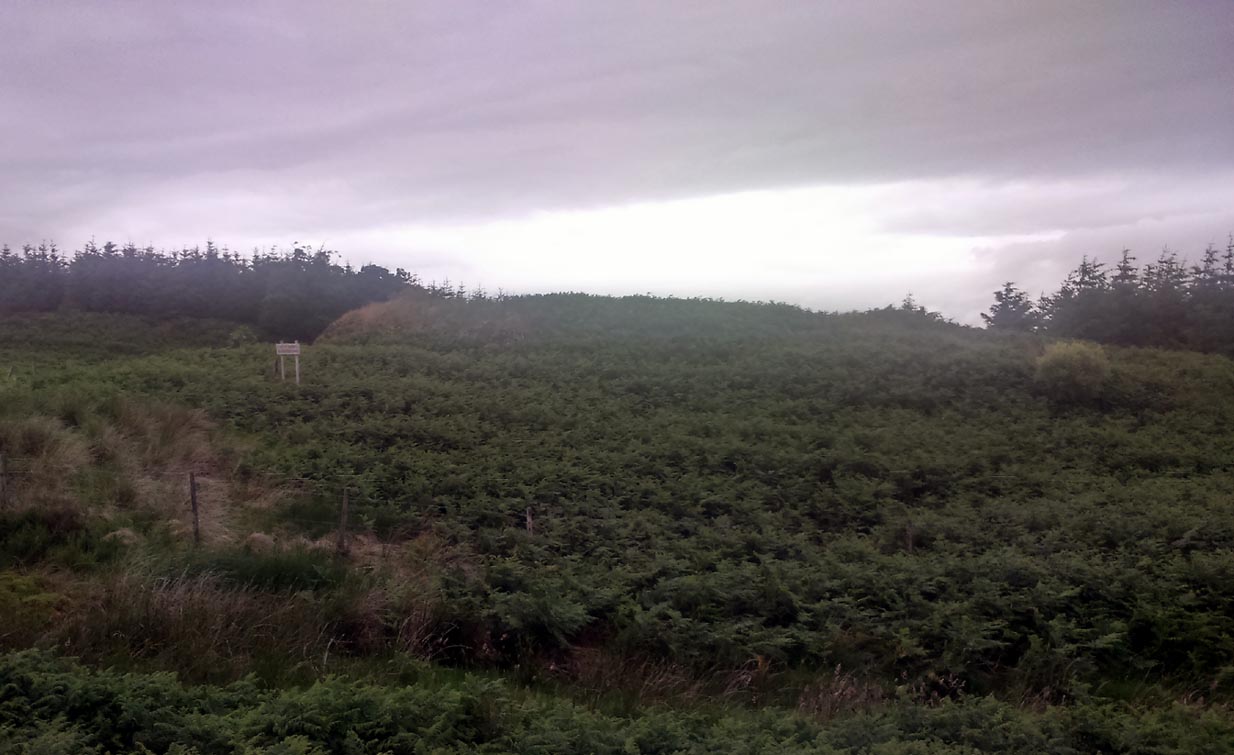
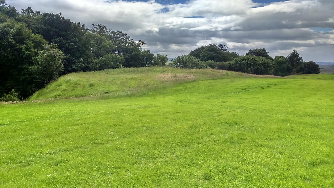
Take the A873 from Thornhill to Aberfoyle, and literally 1 mile west of Thornhill turn right up the track up and past Easter Borland farm (as if you’re heading up to Auchensalt). 250 yards past the farm, a large field opens up. Walk 100 yards east along the side of the wall towards the trees and follow the tree-line upstream 250 yards (don’t go into the lovely little glen) until, on your right, you’ll see a reasonably large area of grassland that rises up, with a steep-ish slope down to the burn below. This is the remains of the broch.
Archaeology & History
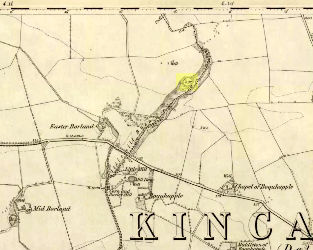
Shown as a ‘Keir’ on the 1866 OS-map, this is an old Scottish dialect word, barely used at all nowadays (folk need to start using it again!) which meant “an ancient fortification” or “rude forts”. The word is mentioned in early Statistical Accounts in 1795 and in the Second Account of 1845 the “Kiers at Auchinsalt” are mentioned specifically, albeit in passing….
Auchinsalt ‘Keir’ on 1866 map
When we visited the site yesterday, very little could be seen due mainly to the summer vegetation covering the area. A very small section of open walling was noted on its western side, and beneath the undergrowth a roughly oval structure was in evidence on the rise between the edge of the field and the drop into the small glen below. Something obviously man-made lies beneath the grasses, but in the last 100 years or so there has been debate as to whether it was a fort, a dun or a broch. The consensus at the mo, tells Euan Mackie (2007), is that it’s a broch!
Auchinsalt broch, looking east
Measuring some 25 yards across, the walling that makes up the broch was between 4-6 feet wide all round, and about 2 feet high. There seemed to be aggregates of large scattered stones inside and outside the main oval feature. If there was an entrance, it seemed to be at the western side, but I wasn’t sure about this. In truth, unless you’re a hardcore broch fanatic, you’d be truly disappointed with the dilapidated state of this monument. Much better ones can be seen just a few miles away…
References:
Chrystal, William, The Kingdom of Kippen, Munro & Jamieson: Stirling 1903.
Grant, William (ed.), The Scottish National Dictionary – volume 5, SNDA: Edinburgh 1960.
MacKie, Euan W., The Roundhouses, Brochs and Wheelhouses of Atlantic Scotland c.700 BC-AD 500, BAR: Oxford 2007.
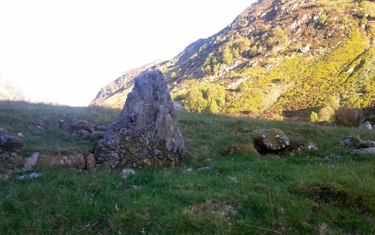
Venture along the A822 Crieff to Dunkeld road, turning down into the gorgeous Sma’ Glen. Nearly 1 mile past Ossian’s Stone, just past where the road crosses the River Almond, walk along the track on your right where the big boulder sits. Past the boulder, walk up the grassy slope to the left. A standing stone will catch your attention, which sits in the walling. Y’ can’t really miss it!
Archaeology & History
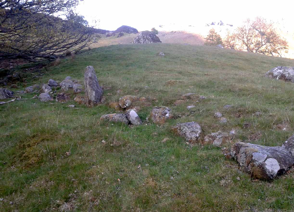
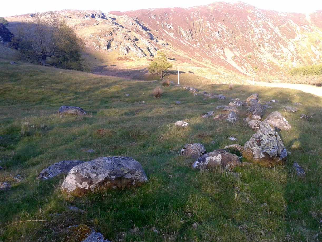
Rediscovered by Paul Hornby in 2015 at the end of a day’s excursion to the neolithic sites a few miles west of here, I can find no references at all to the denuded remains of what seems to be a typical prehistoric enclosure.
Looking down the west wallThe southwestern walls
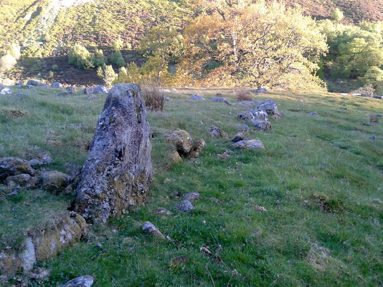
Constructed around a natural rise in the land 60-70 yards above the River Almond, the enclosure has that ‘Iron Age’ look about it (it may be earlier). Shaped like a giant ‘D’ (and clearly visible on GoogleEarth), the extensive walling that makes up the site—about a yard wide all the way round—is far from small, measuring some 60 yards (54.8m) at its greater longer axis roughly north-south, by 54 yards (49.5m) east to west, with a circumference of about 170 yards (155.5m). The much-denuded walling that defines the perimeter is comprised of a number of large stones with thousands of smaller packing stones that are mainly overgrown. A large ‘standing stone’ about 3 feet tall is the most notable feature nearly halfway along the western wall.
Small standing stone in wall
In all probability this enclosure would have been in use since its construction in the Iron Age period all the way through to the coming of Fuadach nan Gàidheal (the Highland Clearances) in the 19th century, as the people here were pragmatists who made best use of what was around them. It is likely to have ended its days as an area where cattle was contained.
Acknowledgements: Huge thanks to Paul Hornby for his assistance with site inspection, and additional use of his photos.
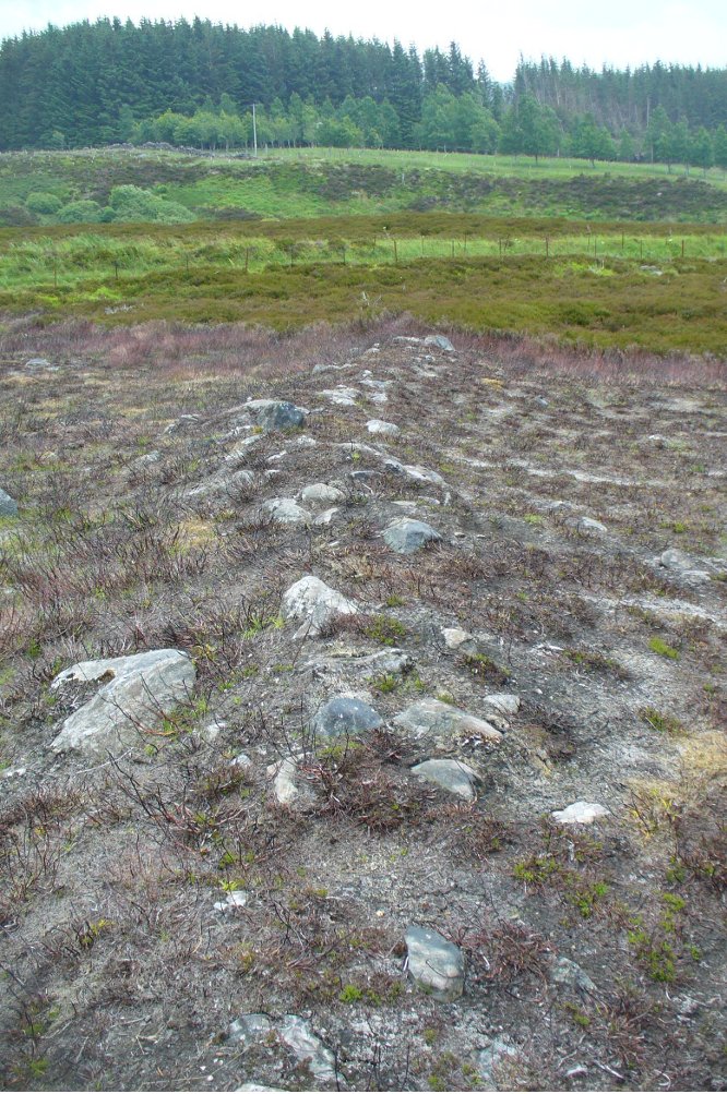
Start at the Askwith Moor parking spot on Askwith Moor Road, then walk down the road (south) 300 yards till you reach the gate and track on the other side of the road, heading southeast. Following the track onto the moor and take the footpath on your right after 75 yards. Follow this along until you hit the gate & fence. Climb over this, then follow the same fence along (left) and down, and keep following the fence and walling all the way on until you reach the very bottom southwestern edge of Askwith Moor itself. Now, walk up the slope to your right and, near the top of this rise 250 yards away, past Lower Lanshaw 01 carving, in some ancient walling, you’ll find it!
Archaeology & History
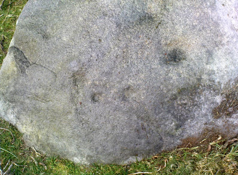
A very faded cup-and-ring carving can be found about 30 yards northeast of the Lower Lanshaw cup-marked stone, just as the hill slopes down to the overgrown stream. It rests on the lower edges of the prehistoric (probably Bronze Age) enclosure in which other archaeological remains can be found. Although the photo here highlights what seems to be 3 cups on the south-face of the rock, only one of them seems authentic. A pecked “line” also seemed evident, but the light conditions were poor when we were here. It does seem that there’s a faded ring around one of the cups, as you can see in the photo.
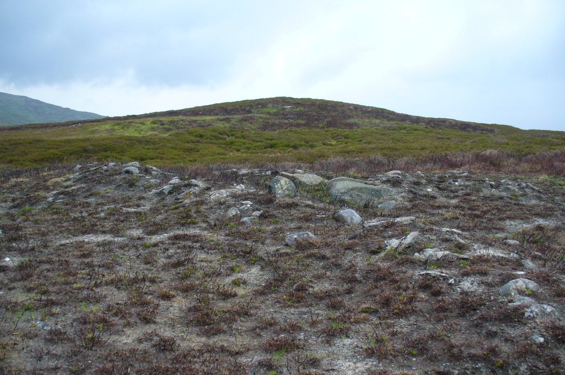
Take the directions to find the Carn Ban giant cairn. Once there, you’re in the middle of the enclosure—or near enough!
Archaeology & History
This is one of several very large extensive prehistoric enclosures that stretch across the undulating rocky plains of this wild moorland, high up below the mountain-tops south of Aberfeldy. Although humans are scarce up here nowadays, in ancient times it was a very different ballgame.
Internal line of wallingEastern edge walls
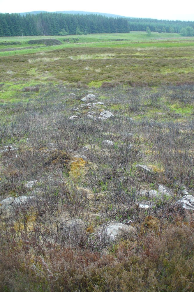
Extensive and well constructed walling, measuring an average of 2-3 yards across and several feet high in places, encircles the giant White Cairn some distance away from it, running for a third-of-a-mile (0.5km) in a contorted oval shape. The walling is pretty much continuous except for where the modern tracks have destroyed two sections of it (and other monuments within) and where entrances or ‘doors’ allowed access on the west, north and eastern sides. The circuitous route of the walls appears to start and end at a small unnamed stream at its southern end.
Outer northeastern walling
Inside the perimeter walls, there are scattered examples of simple hut circles and cairns—some singular, others for families, and others that may be clearance cairns. It’s difficult to say without excavations. On the top northwestern side of the enclosure there is another, smaller enclosure attached to the main mass—seemingly earlier in construction than the giant creature its attached to—which overlooks the curious Shaman’s Lodge double hut-circle 75 yards to the west. This and much of the internal area was, when we visited, covered in extensive and deep heather, so we couldn’t get a clear picture of the entire site.
We might never know exactly how many people used this site, but we can say with some certainty, due to the remains found inside and around the place, that it was used by lots of people over many centuries, not just for what modern homo-profanus defines as ‘utilitarian’ purposes, but also important rituals were practised herein (though we are looking at an ahistorical period before the boundary of ‘sacred’ and ‘profane’ had been defined).
For antiquarians and explorers, this region is a must! A weekend of sleeping rough up here might well be in order!
References:
Stewart, Margaret E.C., “Strath Tay in the Second Millenium BC – A Field Survey”, in Proceedings Society Antiquaries Scotland, volume 92, 1961
Acknowledgements: Huge thanks again to Paul Hornby for his assistance with site inspection, and additional use of his photos.
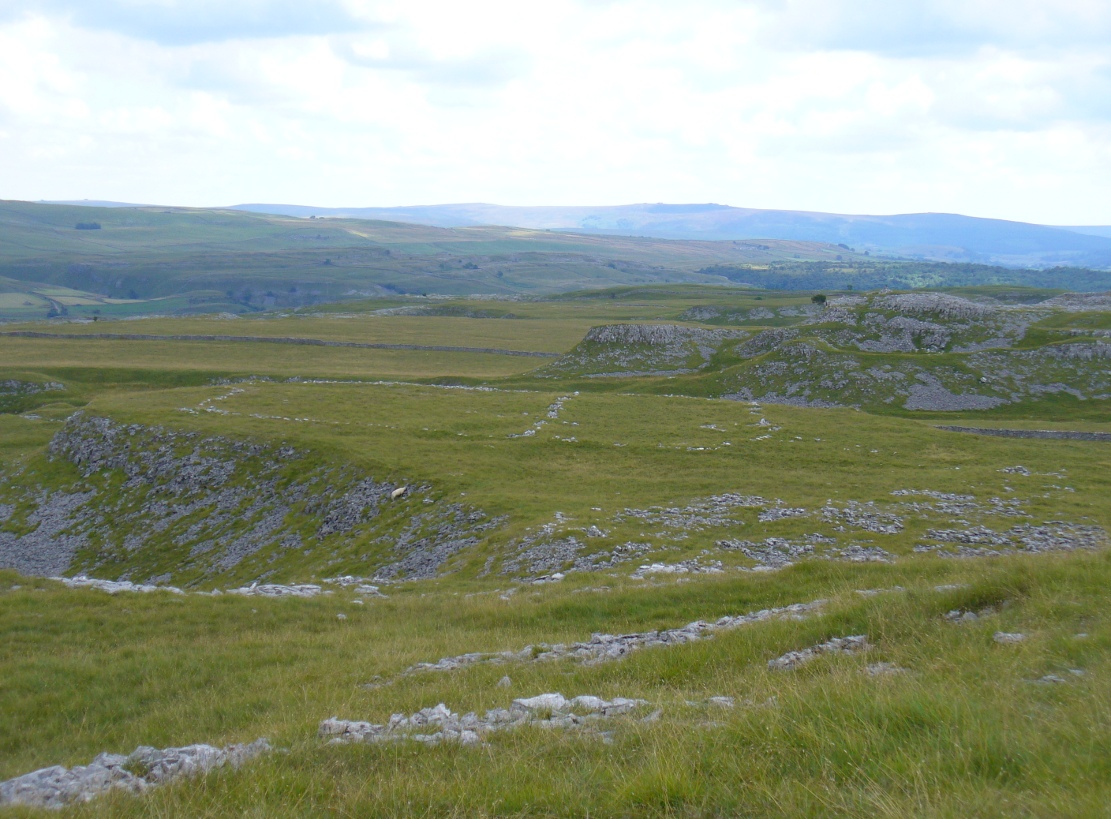
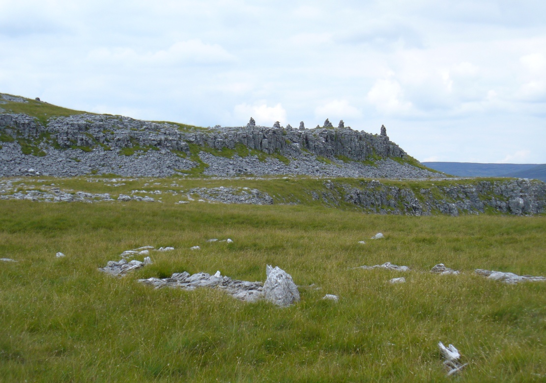
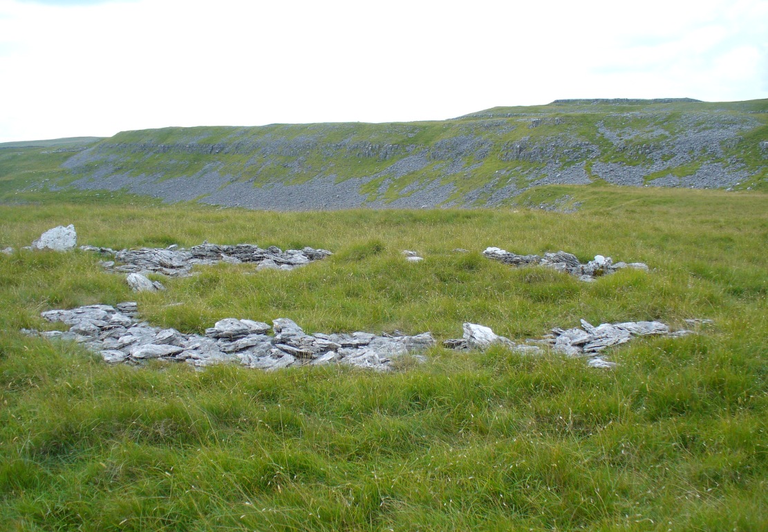
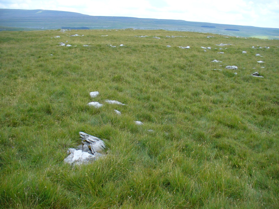
Go up the B6160 road, heading for Kilnsey Crag. A few hundred yards past the famous crags, take the little road to Arncliffe. About a mile up, where you reach the second building on the left-side of the road, walk up behind here, up the steep fields and towards the craggy heights above. Keep right uphill till you see the cluster of cairns on the peak above; but before reaching them, walk over the rocky landscape to your left (southeast) and you’ll eventually see an excess of straight walling a coupla hundred yards away. That’s it!
Archaeology & History
A bittova climb to get here – but well worth it in the end. On a spur of land amidst the outstanding limestone plateaux less than a mile south of Arncliffe village, rising near the silent ghostly cairns upon Knotts ridge above it, we come across an extensive prehistoric settlement complex. It is one of many in this upland region.
Looking south at the settlementKnott cairns above the settlement
Poorly described (if at all) by official archaeology websites, this place is big! All that we can see today at ground level are lines of very extensive lines of enclosure walling, between one and three feet high, intersecting each other and forming very large rectangles growing further and further out from each other towards the western scree. Much of the walled structures are in good condition if they are prehistoric, as presumed by archaeologists; but it seems obvious that the site was in continuous use by local people for domestic and agricultural purposes all through medieval and later periods.
One of the settlement hut circlesRaised lines of ancient walling
The longest stretch of visible walling runs from northeast to southwest and measures 175 yards long (160m), with several stretches of parallel walling splitting the settlement into different sections of large enclosures all attached to each other. These parallel walls measure a maximum of 54 yards (49.5m) and run northwest to southeast. The aerial image of the site shows the structures very clearly in some parts. Others are more vague and some are difficult to see at ground level. But the settlement as a whole cannot be missed. Several hut circles have been built inside the main rectangular enclosures, with two others faintly visible on the outer edges.
As far as I’m aware, no excavations have taken place here, so we are still grasping at periodic straws when it comes to dating the place. When Arthur Raistrick (1929) wrote his article about the associated enclosures like that at Blue Scar, a short distance to the east, he thought them to be Iron Age in origin. He may well right. A singular enclosure circle can be found a few hundred yards to the south.
References:
Elgee, Frank & Harriet, The Archaeology of Yorkshire, Methuen: London 1933.
Raistrick, Arthur & Chapman, S.E., ‘The Lynchet Groups of Upper Wharfedale, Yorkshire,’ in Antiquity, volume 3, 1929.