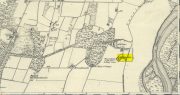
On the west-side of the River Spey from Fochabers, follow the road-signs taking you south on the B9015, and near Inchberry is a tiny road on your right (careful not to miss it). Go along here to the end of the long straight road and turn right, down the track. When you reach the trees, bear left along the track to St Mary’s, Orton, marked “Private road”. 🙂 Parking is limited to one car only but very quiet.
Archaeology & History
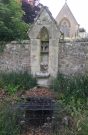
St Mary’s Well, Inchberry (21st Century Pict)
Set in a stunning location next to the river Spey with a magnificent view of Ben Aigan to the south, St Mary’s Holy Well and Pool is easy to find behind the Chapel / Mausoleum wall, dedicated to the Duff Family. There is a small stone basin in the wall which may have been the Chapel font. At the time of my visit the weather has been dry and sunny for some time. The pool below the iron grate has been recently cleared of leaves before my visit, with no standing water but the stones on the bottom of the pool looked damp. And with the cemetery above and behind the wall, perhaps it was for the better.
It was clear and running, said J.F.S. Gordon (1880) at the end of the 1700s, but when he came to write about it the flow “has ceased for many years, and is now only a feeble, filthy, stagnant Driblet for the use of cattle.” Pilgrimages were made here on the first Sunday in May, and water collected from the site was kept for a year, in return for an offering (usually a stone or other inanimate object) that enabled the magickal spirit of the well to enact cures.
Folklore
A site described by Watson (1868) as being “long held in superstitious reverence”, the well was said to cure whooping cough, eye problems and joint conditions. It had thoroughly un-christian shennanigans practised here by local folk, much to the consternation of the usual culprits! Visited extensively by people from far and wide, Mr & Mrs Morris (1981) told,
(21st Century Pict)
“The visits displeased the Kirk and there were various summonses to the Session for “going supersticiously to a Vell at Speyside” and of persons who “kneillit about the chappell and drank the water.” The minister at Ruthven reported that a large number had gone to the chapel well “thrie Saturdays before Lambas and thrie efter called the six silie Saturdayes, and that the conventions wer on the night or before day in the morning.” And “quhairas zierlie about Lambnes, the ignorantes repaired to ane wel at this kirk, called Our Ladie Wel, superstitiouslie, and kneeled about the said kirk, it is reportit that the evil is removed.” This may be the well associated with the White Witch, Dame Aliset, who cured a fairy child with simples and the well water.”
References:
Bord, Janet, Holy Wells in Britain – A Guide, HOAP: Wymeswold 2008.
Watson, J.& W., Morayshire Described, Russell & Watson: Elgin 1868.
Acknowledgements:Huge thanks for use of the Ordnance Survey map in this site profile, reproduced with the kind permission of the National Library of Scotland.
Cup-Marked Stone (destroyed): OS Grid Reference – NJ 4124 5308
Archaeology & History
Diagonally across the road from Killiesmont, about a hundred yards up the sloping field on “a piece of ground called the Helliman Rig,” could once be seen a large flat stone with cup-markings on its surface. Walter Gregor (1881) told that,
“It lay on the top of a rising ground, and commanded a very wide view of the country, stretching for many miles over the hills of Banff and Moray. In a part of it the rock–a kind of slate–came to the surface. In the rock were cut out nine cups in three rows.”
The carving was earlier described in one of the Topographical Gazetteers of Scotland (1848) where its story is bound up with local tradition and folklore of the land where it lie. There it was described as being “a flat circular stone of about 8 feet in diameter, in which there are a number of holes, but for what purpose tradition is silent.” Subsequently the local historian J.F.S. Gordon (1880) talked of this “large flat circular Stone, of about 8 feet in diameter, in which there was a number of half-pierced holes…. It was too large for a Quern or even a Millstone; and its purpose remained an enigma.”
The stone came to light when a local farmer was digging in the field and, “at the upper end of the Rig, there was found a rude Cist among a heap of stones, which contained ashes.” The cup-marked stone was “turned up” at the same time. It has sadly been destroyed—along with the associated cairn that probably had some relationship with the carving. Prehistoric tombs and rock art are frequent bedfellows and it seems likely that the equation occurred here. But the location of the site had some fascinating local lore told of it…
Folklore
The location of this carved stone in the field called ‘Helliman Rig’, was also known as the Guidman’s Croft or the Gi’en Rig. This was a portion of land that was never to be touched or ploughed as it was “given or appropriated…to the sole use of the devil, in order to propitiate the good services of that malign being.” This devilish tradition superseded the earlier faith of it being a place set aside for the fairy folk and their allies—nature spirits no less. And it’s a tradition found in many places across Scotland and elsewhere, as the account in the Scottish Gazetteer told :
“Like other crofts of this description in Scotland, the present remained long uncultivated, in spite of the spread of intelligence (pedantic bastard! PB). The first attempt to reclaim it was made not more than 50 years since, when a farmer endeavoured to improve it; but, by an accidental circumstance, it happened that no sooner had the plough entered the ground than one of the oxen dropped down dead. Taking this as an irrefragable proof of the indignation of its supernatural proprietor, the peasant desisted, and it remained untilled till it came into the possession of the present occupant…”
This of course fortified the old folklore in the eyes of local people. I’ve found that even up to recent times, such folklore is still held quite seriously by some of the old folk in the mountain villages and hamlets.
Cross (destroyed): OS Grid Reference – NJ 3755 4408
Also Known as:
St Fumac’s Cross
Archaeology & History
In the ancient tiny hamlet of Botriphnie, local historian J.F.S. Gordon (1880) told us that:
“About 40 years ago, a Cross of rude picked stone, in low relief, and about 5½ feet high, by about 3 feet broad, stood within the Kirkyard of Botriphnie. Unfortunately, about the time indicated, the Stone was broken up by a Blacksmith, who used it as a Hearth for his Smiddy! This had probably been the ancient Cross of St Fumack’s Fair of Botriphnie.”
This little-known saint has a feast day of May 3, when curious ceremonies were performed in and around his holy well, found just outside the churchyard to the northeast. Little is known about Fumac, but he was said to have been the first Christian missionary in this part of Scotland.
References:
Gordon, J.F.S., The Book of the Chronicles of Keith, Grange, Ruthven, Cairney and Botriphnie, Robert Forrester: Glasgow 1880.
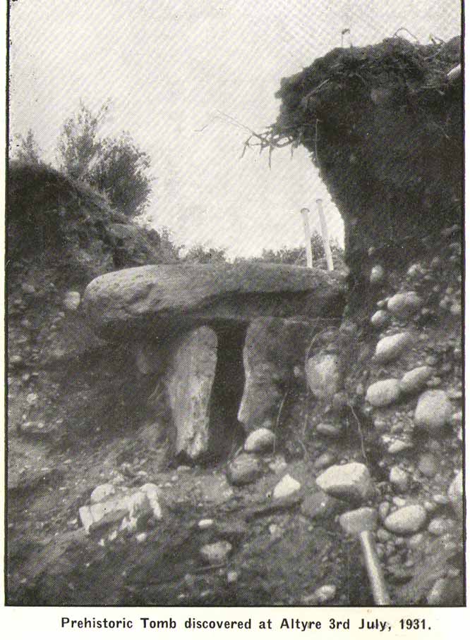
This is another of the many sites in the country that was uncovered fortuitously, as a result of widening the road just west of the Loch of Blairs. It’s in relative isolation from other prehistoric sites. The best description of it was by local antiquarian and folklorist James Ritchie (1932), to whom we owe our gratitude for the old photo. “This cist,” he wrote,
“as such tombs are called, had been discovered by workmen who were digging sand from a mound just by the main road to Grantown. Flat, rectangular stones formed its ends and sides; its top was a single slab of massive proportions. All around were packed smooth. water-worn boulders, that had once lain in the bed of the Findhorn. The opening of the cist revealed the ashes of some long-departed dweller in Moray, together with pieces of what had been beautifully moulded pot of clay. On examination of the remains by antiquarian experts, the date of the burial was estimated to be at least a thousand years BC.”
The attached photo makes the site look larger than it is; as the length of the chamber is just 2ft 7in long, by 1ft 8in across, with the covering stone being nearly twice as large as the cist itself. The urn found inside the cist now resides in the Scottish National Museum of Antiquities.
References:
Ritchie, James B., The Pageant of Morayland, Elgin Courant 1932.
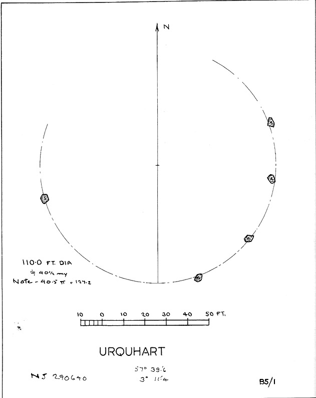
Described in early local history journals, this stone circle of many names is composed of mainly small upright stones — though one of them stands nearly six feet tall — yet it has quite a large diameter of 110 feet (or 40.4 megalithic yards). Alexander Thom (1980) measured its circumference as being precisely 127 megalithic yards. It is thought to have originally consisted of twelve stones, but today only five remain. And in a landscape where recumbent stone circles reign supreme, Aubrey Burl (in Thom, Thom & Burl 1980) thought the lay-out of the site suggestive of just such a monument, saying:
“The apparent grading of the stones towards the S-SSW and the 19th century reference by the Minister of Urquhart to “nine tall stones in a circle, two of them at the entrance to the altar” suggest that this may have been a recumbent stone circle, from which the recumbent and its flankers have subsequently been removed. It is noteworthy that the westernmost stone has several small cupmarks on it, a pillar which would have been close to the recumbent in that restricted area where cupmarks are to be found in recumbent stone circles.”
A singular TNA profile entry of the said cup-marked stone will be added in due course. The middle of the circle was dug sometime prior to 1870, but no human or other remains were found.
Folklore
Described by two local ministers as ‘Nine Stanes’ back in Victorian days, with at least one of the stones being recumbent, it was the great Fred Coles (1906) in one of his many articles on the megalithic remains of Scotland who narrated the following tale, told to him first-hand by a local man called Mr T. Geddie, after some of the standing stones from this circle were removed in the nineteenth century.
“One of the stones,” wrote Mr Geddie, “was to be taken away to be built into a new steading at Viewfield. Mr Brown thinks this was prior to the building of the Innesmill steading, which dates from 1843. No sooner had the Stone been deposited in the toon, however, than uncanny signs and omens began to manifest themselves, and it was resolved to get rid of it. While it was being taken back to its original position, the horse stuck or fell when taking a somewhat steep little brae, and the Stone was taken no further, but buried where it was. The spot it about 80 or 100 yards from the circle.”
Grinsell (1976) also tells the tale that if you visit the circle at midnight and walk round the circle three times, the devil can appear.
References:
Coles, F.R., ‘Report on Stone Circles Surveyed in the North-East of Scotland, Chiefly in Banffshire’, in PSAS 40, 1906.
Grinsell, Leslie V., Folklore of Prehistoric Sites in Britain, David & Charles: London 1976.
Thom, A., Thom, A.S. & Burl, Aubrey, Megalithic Rings, BAR 81: Oxford 1980.