High Street Barrow, Towthorpe, East Yorkshire

Tumulus:  OS Grid Reference – SE 881 637

Also Known as:

  1. Towthorpe Barrow 1

Getting Here

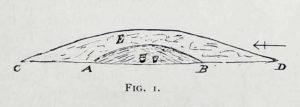
Mortimer’s sketch of Towthorpe-1 barrow

The faded remains of this old burial mound can vaguely be seen just off the right-hand (east) side of the B1248, across the road from the track which leads down to Burdale North Wold farmhouse, between Fimber and Wharram-le-Street.

Archaeology & History

Known as Towthorpe Barrow No.1 in the Mortimer survey (1905), there are a number of prehistoric tombs and other remains close to this site (which will be described on TNA as time goes by).  Some of you might think the lengthy description here a little unworthy, but I believe the extensive archaeological notes on this site by an archaeological legend, J.R. Mortimer, is a good indicator of the dedication and interest to which he gave each and every tomb that he opened (this’ll be the first of many). His slightly edited account told:

“This mound is situated near the centre of the (Towthorpe) group, close to High Towthorpe. Here the green lane…is crossed by the high road from Malton (B1248), through Wharram-le-Street… Part of this road, for some distance south and north of the barrow, is called ‘High Street’ by the old inhabitants of the neighbourhood…

“On 4 May, 1863, the writer, with the assistance of R. Mortimer and two workmen, commenced to open this mound. It was the first British barrow he had the pleasure of examining. A trench 10 feet wide was cut across its centre from the northern to the southern margin…

“The upper portion E, to a depth of 16 inches, consisted chiefly of the surface soil of the neighbourhood, the bottom part of which was reddened as if by the action of fire. Close below this was a stratum of wood and ashes and other dark matter, 2-3 inches in thickness; and then a lenticular bed of tough drab-coloured clay, 29 feet in diameter, and 12-14 inches thick in the centre, gradually thinning towards the circumference. The upper part of this bed of clay, which was in contact with the stratum of wood ashes, was reddened by fire; its under surface had a similar appearance and rested upon what seemed to be a second stratum of burnt and decayed matter, 2-3 inches in thickness, similar to that already described. The clay forming this lenticular bed contained numerous small fragments of grey flint, characteristic of the chalk of the neighbourhood. It must have been obtained from one of the valley bottoms (either Burdale, Wharram-le-Street or Duggleby), in which are exposures of the Kimeridge clay. In these places, angular pieces of flint and chalk crumble from the hillside, and mix with the clay, imparting a greyish colour to it. This is especially the case at Burdale, where there is a fine spring at the base of the chalk, and a small pond resting on the Kimeridge; and it is probably from this place that most of the clay for the construction of this barrow was obtained. It is not easy to explain the method by which the clay was transported, but several tons had evidently been used in this case. Many other instances in which material from a distance has been used in the erection of the barrows of this neighbourhood are recorded in (the Yorkshire Wolds).

“In the centre of the mound, at the base of the lenticular bed of clay and below the ashes (which probably represent the residue of a funeral pyre) stood two food vases, close together, and near to these, decayed bones (the remains of a human body) and a chipped flint. The smaller and more ornamented vase was situated to the south of its fellow. It measures 4.5 inches in neight, 5.5. inches in diameter at the top, and about the same across the shoulders. The ornamentation had been impressed on the plastic clay by a thin square-ended tool, about half-an-inch in length, which showed in the impression of a fine notched structure, and was equally divided into ten ridges about the size of the indentations on the milled edge of a shilling, and almost as truly cut. In the lower groove which runs round the vase are four pierced projections.

“The other vase is about 5 inches high and about 6 inches in diameter at the top and across the shoulders. Three encircling lines of short vertical cuts, rudely and apparently hastily made, previous to baking the vase, represent its entire ornamentation.

“During the excavation we collected from the material of the mound a dozen hand-struck flint flakes of various sizes, and a small splinter from the cutting-edge of a green-stone celt.”

Mr Mortimer returned to do further excavations here on Christmas Eve and Christmas Day in 1865, with the hope of finding more — but apart from a finely-cut knife made of black flint, nothing else was located. This was the first of Mortimer’s hundreds of diggings into the tombs and dykes of East and North Yorkshire.

References:

  1. Marsden, Barry M., The Early Barrow Diggers, Tempus: Stroud 1999.
  2. Mortimer, J.R., Forty Years Researches in British and Saxon Burial Mounds of East Yorkshire, A. Brown: London 1905.

© Paul Bennett, The Northern Antiquarian

Cnoc na Croise, Ardminish, Gigha, Argyll

Cairns:  OS Grid Reference – NR 6439 4828

Also Known as:

  1. Canmore ID 38549

Archaeology & History

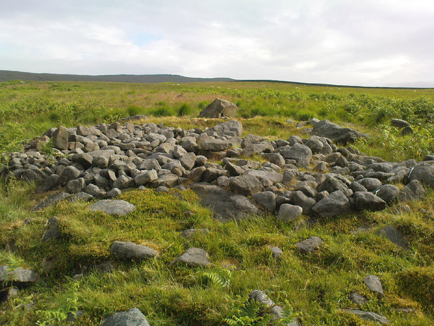
In Thomas Pennant’s A Tour in Scotland and Journey to the Hebrides, 1772 (1790:226), he described there being three prehistoric cairns about four-hundred yards west of Ardminish, or a couple or hundred yards north of the Achamore Standing Stone, on Cnoc na Croise, but they seem to have been destroyed.  At least two of them were between 4 and 5 yards across and contained cists.  A search for the site by the Royal Commission lads in the 1960s found nothing—although they may have been looking in the wrong place (the grid reference given above is an approximation).  Does anyone know anything more about these seemingly lost sites?

References:

  1. Royal Commission for Ancient & Historical Monuments of Scotland, Argyll – volume 1: Kintyre, HMSO 1971.

© Paul Bennett, The Northern Antiquarian

Brink Ends Cairn, Dovestones Moor, Wycoller, Lancashire

Cairn:  OS Grid Reference – SD 96138 42296

Getting Here

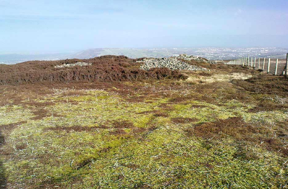
Best way to get up here is to start from the old hall and haunted bridge at Wycoller. From here walk upstream, on the footpath on the south side. It wibbles about following the waters for a half-mile until the moors open up when you reach an old stile, past which is another bridge over the stream. Walk past this (keep on the same side) for another 50 yards, then walk up the hillside where, if the vegetation is low, you can just see a decent-sized collection of rocks. This is the old cairn.

Archaeology & History

I don’t think the site is in the Lancashire archaeological register, but it’s described in John Bentley’s fine local history work, Portrait of Wycoller from 1975. He told that,

“a suspected Bronze Age burial mound at Brink Ends in Wycoller was excavated by Stanley Cookson in 1971 and 1972. Although no interment was discovered, the remains of a fire was found in the centre of the mound with half-burnt twigs and coal.”

Brink Ends Cairn, Wycoller

It’s not unlike some of the giant cairns on Ilkley Moor and elsewhere, though not as big, nor as high, being only about 22-24 feet across. Some of the stones have evidently been taken for use in the local walling, and the ‘cairn’ is in a pretty abject state. It’s a bittova odd spot to be honest. Not 100% sure what to make of it – though flints, arrowheads and similar implements have been found on the moors here close by. Bentley (1975) also told how “Stanley Cookson had strong suspicions that an Iron Age settlement existed in this area, but only time and further exploration will tell.” A sentiment I tend to agree with. And on our first and only visit here — during one helluvan awesome downpour all day — what seemed like an Iron Age hut circle was noted a few hundred yards to the south; though we got so saturated that day that we decided to turn for home soon after looking at this cairn.

Cookson and Hindle (1985) later described this site as a “middle Bronze Age burial cairn of 1400 to 900 BC, adding:

“The 34ft diameter inner circle was excavated during 1956-58 disclosing flints, a hearth with an abundance of charcoal, and four pieces of coal on a round, heavily burnt stone.”

More visits to these moors to check for other archaeological sites are needed in the near future to see what else might be on these unexplored moors.

References:

  1. Bentley, John, Portrait of Wycoller, Nelson Local History Society 1975.
  2. Cookson, Stanley & Hindle, Herbert, Wycoller Country Park, H.Hindle: Colne 1985.

© Paul Bennett, The Northern Antiquarian

Battle Hill Dolmen, Huntly, Aberdeenshire

Cairn (destroyed):  OS Grid Reference – NJ 542 401

Archaeology & History

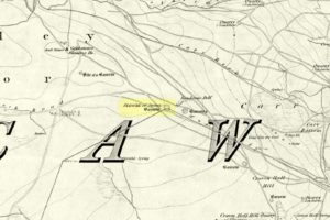
In a short article, ‘Dolmens in Scotland’, written by Dr H.O. Forbes in the esteemed Antiquity journal of June 1929, Dr Forbes reported the former existence of a dolmen-like monument that stood,

“some 70 years ago…at the north or northwestern extremity of Battle Hill which looks down on the town of Huntly on the River Bogie in Aberdeenshire.  In walking from Drumblade to the town, about 3 miles off, one usually took a short cut over Battle Hill.  This bypath diverged from the turnpike road leading north to Banff and led to the top of Battle Hil (400ft), close past the edge of the wood, a few yards within which stood this monument.  It was a typical dolmen, of which I retain a perfectly clear recollection, with its large granite capstone supported by three massive, rudely shaped pillars.  On the aspect towards the bypath, there were some blocks of stone on the ground which may have constituted a fourth pillar or the ruins of a dromos, otherwise the dolmen was in excellent preservation.  It stood about 6 to 7 feet high above the ground level, for I remember it took some climbing for me as a small boy to get on top.”

Folklore

Dr Forbes also described several legends attached to this long forgotten old tomb.  He told “that it was a ruined druid’s altar; that the stones were dropped down through a hole in the devil’s apron when on his way to Knock Hill to deposit the cloven-stone there (a large glacial erratic); and that it is the tomb of a great warrior.”  A story that we find at a number of prehistoric tombs in both Britain and abroad.  At some nearby tumuli, legend told that they stood on the site of a great battle.

References:

  1. Forbes, H.O., ‘Dolmens in Scotland,’ in Antiquity journal, volume 3, June 1929.

  2. Grinsell, Leslie, Folklore of Prehistoric Sites in Britain, David & Charles: Newton Abbot 1976.

© Paul Bennett, The Northern Antiquarian 


Great Skirtful of Stones, Burley Moor, West Yorkshire

Cairn: OS Grid Reference — SE 14053 44541

Also Known as:

  1. Great Apronful of Stones

Getting Here

Various routes to this giant tomb, which happens to be a way off the roads (thankfully!). Probably the easiest way is from the Menston-side: up Moor Lane, turn left at the end, go 200 yards and take the track onto the moor. Just keep walking. If you hit the rock-outcrop nearly a mile on, you’ve gone past your target. Turn back for about 400 yards and walk (south) into the heather. You’re damn close!

Archaeology & History

The Great Skirtful of Stones cairn looking east to Otley Chevin
Great Skirtful of Stones cairn looking east to Otley Chevin

Due north of the Skirtful Spring water source, this is one of Ilkley Moor’s major prehistoric sites: ‘major’ for a number of reasons – not least of which is the size of the thing!  Although getting somewhat overgrown these days as more of the heathlands encroach the mass of rocks that constitute the central ‘tomb’, it is still a formidable heap. Another reason this site is of importance is its position in the landscape: it can be seen as the peak or ‘nipple’ on the landscape from considerable distances north, south and east of here, rising up on the horizon and catching the eye from many miles away. This was obviously quite a deliberate function of the site when it was first constructed – thought to be in the Bronze or Iron Age period (sadly we have no decent excavation here to tell us just when it was made). Another reason for its importance is its position relative to a once huge prehistoric graveyard immediately east. And right next to it we also find a curious circular monument that has never been properly excavated, whose function is unknown. It is also the seeming focal point of at least one, though possibly three prehistoric trackways: one of which goes right past it, though swerves on its southern edge quite deliberately so as to not touch the monument. This trackway appears to have been a ceremonial ‘road of the dead,’ along which our ancestors were carried, resting for some reason at the nearby Roms Law, or Grubstones Circle, a few hundred yards to the west.

Wrongly ascribed as a “round barrow” by archaeologist Tim Darvill (1988), the Great Skirtful cairn was named in boundary changes made in 1733, where one Richard Barret of Hawksworth told that the site was “never heard go by any other name than Skirtfull of Stones.”

In 1901 there was an article in the local ‘Shipley Express‘ newspaper — and repeated in Mr Laurence’s (1991) fine History of Menston and Hawksworth — which gave the following details:

“Mr Turner led the way across Burley Moor to the Great Skirtful of Stones, a huge cairn of small boulders, nearly a hundred tons on a heap, although for centuries loads have been taken away to mend the trackways across the moor… The centre of the cairn is now hollow, as it was explored many years ago, and from the middle human bones were taken and submitted to Canon Greenwell and other archaeologists” – though I have found little in Greenwell’s works that adequately describe the finds here. Near the centre of the giant cairn is a large stone, of more recent centuries, which once stood upright and upon which is etched the words, “This is Rumbles Law.” The Shipley Express article goes on: “Mr Turner explained that ‘law’ was always used in the British sense for a hill, and Rumbles Hill, or cairn, was a conspicuous boundary mark for many centuries. He had found in the Burley Manor Rolls, two centuries back, that on Rogation Day, when the boundaries were beaten by the inhabitants, they met on this hill, and describing their boundaries, they concluded the nominy by joining in the words, “This is Rumbles Law.””

Great Skirtful on 1851 map

Several other giant cairns like this used to be visible on the moors, but over the years poor archaeological management has led to their gradual decline (and in editing this site profile in 2016, have to report that poor archaeological and moorland management is eating into and gradually diminishing this monument to this day).  We still have the Great Skirtful’s little brother, the Little Skirtful of Stones, a half-mile north of here.  The very depleted remains of the once-huge Nixon’s Station giant cairn can still be seen (just!) at the very top of Ilkley Moor 1½ miles (2.65km) west.*  And we have the pairing of the giant round cairn and long cairn a few miles west on Bradley Moor, near Skipton.  The tradition of such giant tombs on these hills was obviously an important one to our ancestors.

Folklore

We find a curious entry in the diaries of the Leeds historian Ralph Thoresby, in the year 1702, which seems to describe the Great Skirtful of Stones, adding a rather odd bit of folklore. (if it isn’t the Great Skirtful, we’re at a loss to account for the place described.) Mr Thoresby told how he and Sir Walter Hawksworth went for a walk on Hawksworth’s land and said how,

“he showed us a monumental heap of stones, in memory of three Scotch boys slain there by lightning, in his grandfather’s, Sir Richard Hawksworth’s time, as an old man attested to Sir Walter, who being then twelve years of age helped to lead the stones.”

As far as I’m aware, this old story of the three Scottish boys is described nowhere else.

Like many giant cairns, the Great Skirtful has a familiar creation myth to account for its appearance. In one version we hear that it was made when the local giant, Rombald (who lived on this moor) and his un-named wife were quarrelling and she dropped a few stones she was carrying in her apron. A variation swaps Rombald’s wife with the devil, who also, carelessly, let the mass of stones drop from his own apron to create the ancient cairn we still see today.

According to Jessica Lofthouse’s North Country Folklore (1976), a Norse giant by the name of Rawmr, “fell fighting against the Britons of Elmet and is buried, they say, on Hawksworth Moor” – i.e., the southeastern section of Rombald’s Moor, very probably at the Great Skirtful of Stones.  I’ve yet to explore the history and etymology of the name Rawmr…

…to be continued…

References:

  1. Bennett, Paul, The Old Stones of Elmet, Capall Bann: Chieveley 2001.
  2. Cowling, Eric T., Rombald’s Way, William Walker: Otley 1946.
  3. Darvill, Timothy, Ancient Britain, AA: Basingstoke 1988.
  4. Laurence, Alastair, A History of Menston and Hawksworth, Smith Settle: Otley 1991.

* Whoever is/was supposed to be responsible for the care of the Nixon’s Station giant cairn monument should be taken to task as it’s been virtually obliterated since when I first came here 30 years ago.  Which useless local archaeologist and/or council official is responsible for its destruction?  Who allowed it to happen?  Why are Ilkley Moor’s prehistoric monument’s being so badly looked after by those who are paid to ensure their maintenance?  Are their heads up their arses, in the sand, or—don’t tell me—the prawn sandwiches are to blame!?

© Paul Bennett, The Northern Antiquarian