From junction 16 on the A74(M) turn off an go up the B7076 road, roughly parallel with the motorway, for about 2 miles, turning right – over the A74(M) – until you hit the T-junction by the lovely hamlet of Newton. At the T-junction turn right again and along down the road for just 300 yards or so. You’ll see the small Skip Cottage, almost overgrown by the tiny roadside on your right. Stop here and look into the field across the road. It’s right in front of you!
Archaeology & History
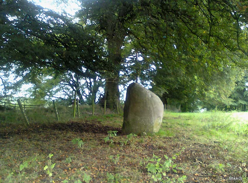
Looking SW
Despite the size and almost romantic setting of this large standing stone, I can find little by way of early descriptions or archaeological reports here. Nearly six feet tall with its long axis aligned east-west and in seeming isolation, I find it hard to believe that we have no other sites or relevant data here. Echoing the work by Alexander Thom (1990:2), Aubrey Burl (1993) makes mention of it as one in a possible “pair” of standing stones, with its companion being “18ft (5.5m) away…in roadside bank,” but this is debatable. This second stone seems as much a part of the old walling. On purely subjective grounds, it gave the impression of once playing a part in a stone circle — an opinion also held by the Scottish Royal Commission (1920) lads after their visit here in August, 1912. Does anyone know anything more about this place?
References:
Burl, Aubrey, From Carnac to Callanish, Yale University Press 1993.
Royal Commission on Ancient & Historical Monuments, Scotland, Inventory of Monuments and Constructions in the County of Dumfries, HMSO: Edinburgh 1920.
Thom, A., Thom, A.S. & Burl, Aubrey, Stone Rows and Standing Stones – volume 2, BAR 560: Oxford 1990.
A huge linear monument that could once be found on the flats just north of the B6271 road running between the villages of Scorton and Brompton-on-Swale, east of the ancient A1 road, has long since been ruined. Although found quite a few miles north of the main Thornborough henge and cursus complex, a number of students still posit that this northern monument was part of the same “ritual landscape” arena.
Plan of the cursus (after P.Topping, YAJ 1982)
First discovered in 1949 following aerial survey analysis by Prof. J.K. St. Joseph, this huge dead straight cursus monument ran for at least 1.3 miles (2.1km) and would have been considerably longer if the self-righteous advance of industry hadn’t quarried it away (such is “progress”!). Built along a southeast to northwest axis, the southern end of the cursus was straight and flattened (as opposed to convex, as found at some cursuses), as Peter Topping’s (1982) illustration of the monument here shows, but the northwestern end of the cursus has not been found. As Mr Topping himself wrote:
“The southwestern terminal, which shows clearly on the aerial photographs, consists of a straight transverse ditch which joins the two main ditches at right angles. Clustering around it was a series of ring-ditch cropmarks. The aerial photographs also show a series of bleach marks between the ditches at the southern end of the cursus, which may represent a series of contiguous mounds. This area of the cursus also features what appears to be smaller outer ditches…”
Topping also commented on a most “noteworthy feature” in the accuracy of the ditches that constitute the length of the monument, being so “remarkably straight considering the distance over which they extend.” Features which, in bygone days, a number of respected archaeologists denied our prehistoric ancestors the ability to execute.
Hopefully readers will forgive me citing more of Topping’s extensive notes regarding the archaeological analysis of this site, but I think they’re worthwhile. Of the ditches that make up the outline of the cursus, he told:
“The ditches of the cursus are the two most prominent features of this site on the aerial photographs. …The only evidence available for the existence of the cursus in the area to be excavated was a section exposed in the adjacent gravel quarry. This section clearly illustrated quite distinct re-cut features visible in the profiles of both ditches, and evidence of this recutting was also discovered in the excavated areas. However, one anomaly which did distinguish the excavated sections from those exposed in the quarry was the variable depth of the ditches. In the quarry-face sections the western ditch had a maximum depth of 60cms, while in the excavated area its maximum depth was 45cm; similarly, the eastern ditch had a maximum depth of 65cm in the quarry and a maximum depth of 43 cm in the excavations. This may have resulted from the actions of hillwash or ploughing reducing the height of the old land surface in this area where the ground naturally rises, or alternatively indicate no more than an uneven depth to the ditches. Their width was fairly consistent, the maximum width of the eastern ditch being 3.40m, while that of the western ditch was 3.85m.
“Recutting in both ditches was indicated by a V-shaped notch beneath the main profile of the ditch…
“Closely datable artifacts were sadly lacking in the ditches, the one possible exception being (a) flint…possibly an arrowhead, from the upper fill of the eastern ditch… The upper fill of the eastern ditch also produced (a) flint…”
But in all honesty, these flint finds were probably of little importance to the cursus itself and can be discounted as of any relevance outside of being stray hunting flints. Three other flints were discovered by the western ditch aswell, again with little significance to the monument. But the next part of the excavation work explored what Topping called the ‘Central Feature’, of which he said:
“Bleach marks on Prof. St. Joseph’s aerial photographs revealed what appeared to be a series of axially-placed contiguous mounds situated between the main ditches, and extending the whole length of the long axis of the monument as then known. The presence of this feature was confirmed in the excavated area. A low central mound was uncovered, within and respecting the lines of the ditches, which had a maximum height of 32cm above the old ground surface.”
Upon further excavation they found what one would have expected: little more than the upcast of earth and gravel dug out from the ditch that makes up the cursus, i.e., spoil-heaps made where they’d dug out the cursus lines with little other significance. This feature is obviously apparent in many cursuses. Of greater interest was the pit- or post-hole on the eastern ditch.
“This was stratigraphically related to the cursus to the extent that it was sealed by the same layer of hill-wash that had buried the cursus ditches. In addition, this feature clearly respected the limits of the eastern ditch. The dimensions of the pit/post-hole were: maximum diameter at its base, 1.12m, the maximum width at its top, 2.10m, length, 4.19m, and a maximum depth of 60cm.
“…Distinct tip-lines were evident leading in and downwards towards the centre of the feature, this central area being relatively stone-free. This could suggest that the feature originally held a post which was subsequently removed at a later date.”
I’d say this notion is highly likely! In the event that a complete excavation could have been made here, it’s probable they would have found other pit-holes into which upright wooden posts were erected around the time the cursus was constructed. When Topping and his team excavated sections of the eastern ditch-floor, they found what appeared to be the truncated base of another post-hole. He told:
“This feature was sectioned and found to be flat-bottomed and to have a depth of only 3cm and a diameter of 25cm. The fill was indistinguishable from the fill of the cursus ditch and contained no traces of organic material…although the exact function of this feature is unknown.”
Topping’s conclusion about the nature and function of this monument is a simple one:
“it can be seen as part of a concentration or complex of magico-religious structures.”
And although this is a somewhat tentative notion based on the limited archaeological evidence here, it does accord with standard views in comparative religion on the animistic relation humans had with natural and man-made monuments from this and later periods of history; as well as reflecting the findings on the origin and development of human consciousness in Jungian and other applied psychology schools. The construction of this gigantic landscape feature occurred at a period in human history when the division between the sacred and the profane had yet to emerge culturally. In all likelihood, Mr Topping’s notion is correct.
In days of olde this once proud tomb stood upright on the slopes below the more prominent Cliviger Laithe tumulus above. But, like many of the ancient ancestral tombs of this region, its days seem long gone. Although we’ve found what may be some traces of the outline of the cairn (further analysis required!), when the legendary Lancashire historian Thomas Dunham Whitaker (1872) wrote about the place, he was already writing about it in the past tense. He said briefly, that “this heap of stones was removed as materials for building a turnpike road” in 1763. The archaeologist Bernard Barnes (1982) told us that “a cist with an inhumation was found. In 1766 another tumulus was removed and an urn found. An axe-hammer is said to have been associated” here. The most lengthy description of this site can be found in Mr Booth’s (1899) short work where, in his summary of various prehistoric sites in this region, he told that,
“The first find recorded in this locality took place at Law House, near Mereclough, in the year 1763, when a mound was opened which covered a kistvaen, or stone cist, which, upon being opened, was found to contain a human skeleton. The information concerning this ancient burial is very meagre, and we have no information as to who were the discoverers of the mound. It may be noted that nearly 70 years before (in 1695) a number of Roman coins were found close to this barrow. The mound also contained a rude earthware vase filled with calcined bones.”
It’s unlikely that the earthworks by the walling hereby represent the denuded remnants of the monument in question, although the rise in the field here may be some remnant of the place, but without further excavation we might never know for sure. However, the recent discovery of what may be remnants of the cairn in an adjacent field requires further analysis. WATCH THIS SPACE – as they say!
References:
Barnes, B., Man and the Changing Landscape, University of Liverpool 1982.
Bennett, Walter, History of Burnley, volume 1, Burnley 1946.
Booth, Thomas, Ancient Grave Mounds on the Slopes of the Pennine Range, R. Chambers: Todmorden 1899.
Whitaker, T.D., History of the Original Parish of Whalley, London 1872.
Go through Killin past the Bridge of Lochay pub, turning immediately down the small lane by its side. After about 3 miles you’ll cross over the small river past Duncroisk. Keep going for another few hundred yards (if you reach Tullich you’ve gone too far), watching out for the gate on your left. Walk up to the top of this field, over the wall and up again. You’ll see a couple of tall trees with distinctive walling next to them, just on a ridge above you. That’s where you’re heading!
Archaeology & History
This is a fine-looking example of a prehistoric enclosure, perched on the edge of one of the grassy knolls on the far western extremities of the deserted village of Tirai. If you walk towards it from the derelict village east of here, the elliptical form of the site gives you the distinct impression that you’ve just chanced upon a seemingly unknown stone circle nestled upon the edges of this gorgeous Scottish glen; but this initial excitement is soon dispelled once you get into the heart of the site!
Southern line of wallingLooking east
Although you’ll find a couple of derelict post-medieval buildings on the western side of this structure, the lay-out of this monument would seem to be Iron Age origin, perhaps earlier. It certainly has all the hallmarks of a walled structure from that period and typifies many others that I’ve explored down the years.
The eastern and southern sections of the walls are in very good states of preservation, although the ground has obviously grown up and around the bases of the stonework. It has a total outer circumferences of about 95 yards (87m), with the many upright stones measuring between 12 inches to more than 3 feet in height. The western section of the enclosure is mostly overgrown but easily traced on foot. Near the centre of the site is a large flattish stone that gave the impression of having an oratory function from where one could speak to the rest of the people sat around the inner edges of the enclosure — but this was a purely subjective impression.
NE sections of enclosureOuter section & ‘standing stone’
On the southern side of the elliptical structure is another, outer line of walling, or a stone alignment of some sort just a few yards long, consisting of just a few upright stones — one of which stands considerably taller than all the others hereby, giving the impression of a standing stone. It has a large natural cup-marking on its southern face.
To my limited knowledge there’s been no excavations here, so one wonders whether or how or if the people of Tirai made use of this much earlier building. The Canmore entry of the place tells:
“The N side of this enclosure is a low turf and stone bank of height 0.3m and is 20m long, spread to about 1.2m. The E side is outlined by large stones set on edge with no evidence of intermediate stone walling or turf. A bank of similar more continuous stone extends to the W from the S of the main enclosure down sloping ground. This type of walling is different from any other on Tirai. The large stones set on end have suggested a prehistoric date for this enclosure.”
References:
Johnstone, A. & Wood, S., “Tirai (Killin Parish), Pre-Enclosure Settlements,” in Discovery & Excavation in Scotland, 1990.
From Port Ellen take the A846 road east to Laphroaig, and on the far side of the village, past the small forested part on your left, walk up the slightly sloping hill alongside the small River Kilbride. Over a couple of walls on your way up, look up the small hill to your right (north) and you’ll see these large standing stones.
Archaeology & History
A triple-stone row no less! Although only two of these stones are upright, a third central prostrate stone is included in archaeological surveys as an original upright. And it seems likely. Although passed over in Alexander Thom’s astroarchaeological analyses, Clive Ruggles (1984) looked at this stone row and found the alignment here to possess no solar or lunar function. But if it aligns north the mythic relationship obviously relates to death, as North “is the place of greatest symbolic darkness” where neither sun nor moon ever rise nor set. There may have been an early association with Alpha Draconis, or Thuban in the constellation of the Dragon: the Pole Star in early neolithic times around which the heavens were seen to revolve by our ancestors and hold the pillar of the sky in place. But we may never know. Perhaps by the time these monoliths were erected, the mythos relating to A.Draconis may have faded…
The stones are found amidst a scatter of other neolithic and Bronze Age remains. In the Royal Commission (1984) report on the stones they described the respective monoliths as follows:
“The north stone, measuring 1.28m by 0.35m at the base and 2.70m in height, rises with a gradual taper, the top curving gently to its highest point at the top of the south side. The centre stone, now prone, has fallen onto its E face and lies embedded in the ground with its upper surface (originally the west face) flush with turf; it is 3m long and up to 0.9m broad. The south stone measures 0.80m by 0.40m at the foot and 2.85m in height. It leans towards the west and the top slopes down sharply from the south to a shoulder 2.1m above ground level on the north side.”
…to be continued…
References:
Burl, Aubrey, From Carnac to Callanish, Yale University Press 1993.
Royal Commission on the Ancient & Historical Monuments of Scotland, Argyll – volume 5: Islay, Jura, Colonsay and Oronsay, HMSO: Edinburgh 1984.
Ruggles, C.L.N., Megalithic Astronomy: A New Archaeological and Statistical Study of 300 Western Scottish Sites, BAR: Oxford 1984.
Tumulus (destroyed): OS Grid Reference – SE 0095 2748
Archaeology & History
Up behind the old pub that was The Mount Skip, high on the ridge above Hebden Bridge and Mytholmroyd, overlooking the Calder Valley for many miles, was once — it would seem — a number of fine prehistoric remains, long since destroyed by the industrial advance of quarrying and such likes. Amidst what seems to have been settlement remains and, perhaps, timber circles, an ancient grave was also known here. In Mr Ling Roth’s (1906) essay on the prehistoric remains of the Halifax region, he wrote:
“In May, 1897, a grave was discovered at a quarry above Mount Skip Inn. The first indications were the rolling down of pieces of urns which the delvers called flower pots. Then in digging into a hole to fix the leg of a crane, human bones were discovered, Mr Crossley Ainsworth told me: “The grave was about 6ft (1.8m) long, from 14 to 18in (35-45.7cm) wide and about 2ft (61cm) deep…the head and feet were almost exactly north and south, with the face right towards the midday sun.” The bones were very brittle and crumbled easily in the hand. There was a lot of charcoal in the grave. In the ends of the grave which were undisturbed, “there appeared to be about 6in (15cm) thick of charred wood and bones mixed together at the bottom. Flints were also found. Also the larger half of a small earthenware vessel which had rolled down into the quarry ; this was picked up by a man named Thos. Greenwood, of Shawcroft Hill.”
The site was mentioned again nearly fifty years later in Geoffrey Watson’s (1952) survey, but with no additional details.
References:
Roth, H. Ling, The Yorkshire Coiners 1767-183; and Notes on Old and Prehistoric Halifax, F. King and Son: Halifax 1906.
Watson, Geoffrey G., Early Man in the Halifax District, Halifax Scientific Society 1952.
This little known site, long since destroyed during the construction of Keighley Railway Station, was found in a curious spot, close to the bottom of the Aire Valley. Most (known) prehistoric burials occur on the higher grounds in this area. And though we don’t appear to have the exact location of the find, it was pretty close to either side of Keighley’s old railway station (which is shown as 100 yards to the other side of the road of the present station on the 1852 OS map). This may position the site as being on the grounds opposite and below St. Anne’s Church; otherwise it was getting closer to where the River Worth runs by. In Keighley & Holmes’ early (1858) work they told that,
“Whilst excavating for the Railway within about a hundred yards of the Keighley station, one of the labourers discovered three urns containing a quantity of human bones. Two of them were unluckily broken, one being large enough to hold eight or nine quarts. The one brought away whole, and seen by the present writer, may hold about a quart; it is somewhat distastefully designed, moulded by hand out of the common clay, without glaze, and rudely ornamented on the outside by some sharp implement. The once animated contents of each urn were covered by a square flat stone.”
This final remark seems to indicate the urns were located in a cist (a small stone grave), but we don’t know whether this was found within the remains of a denuded tumulus or stone cairn. However, considering the lack of any remarks about a large pile of stones (which would have been very noticeable) covering this burial site, it would seem more probable that this site was originally an earth-covered tumulus, whose visibility and knowledge had long since diminished in this part of Airedale.
References:
Keighley, William & Homes, Robert, Keighley, Past and Present, R. Aked: Keighley 1858.
Cursus Monument (destroyed): OS Grid Reference – TL 735 084
Also Known as:
Springfield Barnes Cursus
Archaeology & History
The first cursus monument discovered in Essex, archaeologists were fortunate when they came to excavate the site in 1979 as they found it almost complete. A rarity these days! Close to the Springfield Lyons causewayed enclosure monument, the cursus here was some 45 yards across and 750 yards long. Like a number of other cursuses, the Springfield one was dead straight all the way down, running northeast to southwest with squared terminii at both ends. (of the Bi category, as Loveday called them) And it appears to have had quite a long period of use.
Springfield Cursus (painting by Frank Gardiner)
The ditch that constitutes the very outline of the cursus — averaging between 3-4 feet in depth all round — was cut into the earth in the neolithic period. It had small ‘entrances’ at certain points along its longer axis, both on the east and west sides. The flat ends of the cursus were both ‘closed’, without entrances or breaks of any kind. Some depositional remains were found scattered at different spots along the course of the ditch: neolithic pottery and flints in both the northern and eastern ditches, but archaeologists were unsure whether these deposits were left at the time the monument was in use, or at a later period — though it seemed consensus opinion that the deposits were from a period when the cursus was in use. Charcoal remains were also found, but these were associated with an internal timber circle that was erected within the northeastern end of the cursus. The timber circle was found to have consisted of 14 upright wooden posts arranged in a near-complete ring, some 26 metres in diameter. It seems highly likely that this part of the monument had some ritual or ceremonial function relating to the dead (“mortuary practices” is the term used at the moment!).
Later excavation work here in 1984 found there to be various other linear and pit-like features within the confines of the monument, and what seemed to be the remains of a barrow beyond its eastern end.
Archaeologist David McOmish (2003), thought that “alignment is also significant,” saying that the “Springfield Cursus, 700 metres long, is aligned on a smaller enclosure some 300 metres away.” The alignment potential here was first suggested by Pennick & Devereux (1989), albeit pointing “to the village of Wexford just over two miles to the southwest.” McOmish also suggested there may have been some an astronomical reason for the alignment of the monument NE-SW, but I’m not aware whether this has been explored further.
The creation of these huge monuments had obvious relationships with human death rites, the spirits of trees, and celestial gods. But much more research is needed at these sites if we’re to find out more about the nature of these prehistoric giants in the landscape.
References:
Buckley, D.G., Hedges, John & Brown, N., “Excavations at a Neolithic Cursus, Springfield, Essex, 1979-85,” in Proceedings of the Prehistoric Society, volume 67, 2001.
Hedges, John D. & Buckley, D.G., Springfield Cursus and the Cursus Problem, Essex County Council 1981.
Loveday, Roy, Inscribed Across the Landscape: The Cursus Enigma, Tempus: Stroud 2006.
McOmish, David, ‘Cursus: Solving a 6000-year-old Puzzle’, in British Archaeology, 69, March 2003.
Pennick, Nigel & Devereux, Paul, Lines on the Landscape, Hale: London 1989.
Go northwest along the country lane running between High Utley (on the outskirts of Keighley) and Steeton known as Hollins Lane, which then becomes Hollins Bank Lane. You’ll see the fine castle building as you go along, known simply as The Tower arising from the top of the tree-line. As you get to the driveway leading down to the Tower, a less impressive farm building is on the other side of the road, known as Hollins Bank Farm. On the right-hand side of this house is an old overgrown road. Walk along here to the end, going into the field immediately left where a small group of stones can be seen halfway up the field by the tree. You’re here!
Archaeology & History
First discovered one sunny afternoon on April 7, 2010, in the company of Buddhist scholar Steve Hart, this is a really curious carving, inasmuch as it seems to have been deliberately carved around what may be curious naturally eroded cup-forms. You’ll have to visit it to see what I mean. They’re a bit odd. Almost too perfect as cups to be the ancient eroded ones we’re used to looking at. But this aside….
…and againDragon Stone, looking NW
It’s a lovely flat stone, with curvaceous lines running across the middle and edges and into cup-markings. Although some of the cups give an impression of being natural, others have the authentic-looking ring to them, with at least one of them possessing a near-complete ring encircling it (as you can faintly see in the close-up photo here). There are at least 19 cup-markings on this stone, and four main ‘lines’ running roughly in north-south directions, with the cups interspersed between them. At the top (north) end of the rock, separated by a crack, the lines stop and we just have some cup-markings. The crack in the stone may have been functional here.
Although graphically different, the carving has a similar feel in design (for me at least) to that of the Wondjina Stone at Rivock Edge, on the other side of the Aire Valley a couple of miles east of here — though this newly found carving is in a better state of preservation. The small scatter of rocks around it seem to have been unearthed or moved recently by the land-owner (who aint keen on you looking on his land, so be careful) and the good state of preservation may be that they were only unearthed sometime this century. We must also keep in consideration that the lines that run across the surface of this stone are water-lines and may be more the result of Nature’s hand than humans. It’s obvious that some human intervention has occurred here, but it may be difficult to ascertain the precise degree of affectation between the two agencies.
Close-up of cups & lines
According to the archaeological record-books there are no carvings here, but another simple cup-marked stone accompanies this more extravagant serpentine design just a few yards away; a simple cup-marked stone may be seen at the top of the hill; and the faint Currer Woods carving can be found 0.68 miles (1.09km) due west of here, on the other side of the small valley. Other outcrop stones scatter the fields and slopes here, some of which still need checking to see whether or not further carvings exist.
…And for those who may bemoan my seemingly romantic title of the carving: remember! — close by in Steeton township, between the years 1562 and 1797, there was an old field-name known well to local folk, of “one parcel of arable land in town field called Drakesyke, 3 acres”, i.e., the dragon’s stream or dyke. (Gelling 1988; Smith 1956)
References:
Clough, John, History of Steeton, S. Billows: Keighley 1886.
Gelling, Margaret, Signposts to the Past, Phillimore: Chichester 1988.
Smith, A.H., English Place-Names Elements – 2 volumes, Cambridge University Press 1956.
Go over Ilkley Bridge and take your first left, on & over the roundabout, then follow the road as it bends uphill. Keep going until you reach the fields and moors either side of you, up Hardings Lane, stopping at the bend in the land where it meets a couple of dirt-tracks. Go up the track onto the moor and follow this right into the moorland (avoiding the path to your right after a few hundred yards) where it follows the edge of the walling again. After a few hundred yards there’s a gate on your right. Go thru this and, after 40-50 yards, walk up into the heather. You’re damn close!
Carving no.484
Archaeology & History
This is another cup-marked stone that’ll only be of interest to the petroglyphic purists amongst you, as it’s another one of those incredibly interesting single cup-marked rocks — this time with an additional single line running from it! WOWWWW….! The photo here just about does it justice, as in some light conditions you wouldn’t even notice it. There’s also the possibility that this ‘carving’ was actually Nature’s handiwork.
It was first described by our old mate Stuart Feather in 1965, and was then included in Boughey & Vickerman’s (2003) survey as stone 484, describing it as, “medium-sized, approximately square rock of fairly smooth grit. One cup with groove leading from it.”
References:
Boughey, Keith & Vickerman, E.A., Prehistoric Rock Art of the West Riding, WYAS: Wakefield 2003.
Feather, Stuart, “Mid-Wharfedale Cup-and-Ring Markings: Nos. 36, 37 and 38, Middleton Moor, Ilkley,” in Cartwright Hall Archaeology Group Bulletin, volume 10, 1965.
ACKNOWLEDGEMENTS: to Richard Stroud for use of his photo