From Killin heading out along the northern Loch Tay road, turn left just past the Bridge of Lochay hotel and go right to the very end of Glen Lochay, just past Kenknock. From here you’ve gotta keep walking along the glen’s dirt-track, and when you go through the third gate along (about a mile), another 100 yards on, keep your eyes peeled for a reasonably large boulder on the left of the track. This is your marker to go up on the right-hand side of the track, where the large stone is about 20 yards up the slope.
Archaeology & History
Three cup-marks & their lichen
Not far from a prehistoric hut circle relocated by archaeologist Dugald MacInnes I found this, a previously unrecorded cup-marked stone, when I was ambling about around the top of this beautiful valley last week. It’s only a simple cup-marked stone with two very distinct cups and a probable third in the middle of the well-defined ones. A covering of aged lichen was living on the carved rock and it seemed that there may have been other cups beneath the lichen — but I’ve got a real love of these old plants and wasn’t about to tear them from their homely stone.
There are some other little-known unrecorded human remains all along the slopes above here, which I’ll have a look at when next up this Valley of the Black Goddess…
From the bus station in town, walk across the road and to your right, as if you’re heading into the town centre. Barely 100 yards on where you turn left, you’ll see the Blue Stane Hotel across the road right in front of you. The stone in question sits in a small forecourt on the other side of the metal fence (as the plaque describing the stone tells).
Archaeology & History
Although the Blue Stane is well known to local people in the ancient coastal town of St. Andrews, outside of the area little seems to be known of the place. Even the Royal Commission (1933) report for Fife didn’t include the stone in its survey – and the site is east enough to miss it if you walk past too quickly and don’t have an eye for all things megalithic! When Paul Hornby and I came here, it was pretty easy to find. It helps with there being a small plaque in front of the aptly-named hotel, giving a small history of the stone.
The plaque that tells the taleThe Blue Stane
Standing—or rather, resting—in front of the Blue Stane Hotel, the stone has obviously seen better days. Cut in half from its original size, the small upright block certainly has a very blue haze to it and was probably a prehistoric memorial stone, perhaps attached to a long forgotten tomb somewhere close by. Nowadays the little fella is only 2 feet high … and is somewhat reminiscent of a petrified Tyrion Lannister: proudly assertive despite his shortcomings! And long may he reign…
Folklore
The historian and folkorist, A. Lindsay Mitchell (1992) told that the stone here was “more of a reddish sandstone colour”, which passed me by, as I’m brilliantly colourblind! But the fine lady also gave us one of the little known creation myths of the stone, saying:
“Legend has it that an angry giant threw this substantial block of whinstone at the missionary, St. Rule, who had usurped the giant’s influence. However, legend also records that the giant was not one of life’s bolder characters. He made sure that he remained far enough away frm this upstart, St. Rule, and threw the stone from the safe vantage point of Blebo Craigs, about 5 miles away.”
In Robertson’s (1973) fine work on the history of St. Andrews, he tells how the Blue Stane,
“comes down in the annals as having been a stone altar of pagan times. It was used for long as a meeting or trysting place, and was regarded with superstitious awe by passers-by. Men would give it placatory pat and women a cautious curtsey in the way-going. It is said that the pikemen of St. Andrews touched it assurance before departing in 1314 for (the battle of) Bannockburn.”
References:
Mitchell, A. Lindsay, Hidden Scotland, Lochar: Moffat 1992.
Robertson, James K., About St. Andrews – and About, J. & G. Innes: St Andrews 1973.
Acknowledgments: Huge thanks to Paul Hornby for use of his photos for this site-profile.
This once important healing stone that was moved a short distance (from grid reference SN 1775 1875 to SN 1770 1874 according to officials) to its present spot, around 1925, whilst having a long history according to the folk traditions of Carmarthenshire, was previously questioned as an authentic site by none other than Prof John Rhys (1875), following his visit to the site in the 1870s. Although Rhys seemed an isolated voice, some modern archaeologists have also questioned its veracity. It’s difficult to say precisely what the original nature of the stone may have been, but it was certainly accommodated in medieval times as a healing stone and used in conjunction with a pagan well – which was of course, accommodated by the Church. If the stone itself had a megalithic pedigree, as some have believed, we know not what it may have been…
As Janet & Colin Bord (2006) wrote, the stone “still survives, but to the casual observer it looks like any other abandoned block of stone,” sitting innocuously within the ring of trees surrounding the church. An early account of the stone was written by E.L. Barnwell (1872), who told:
“The present church of Llangan in Carmarthenshire is a wretched structure, built in 1820, and is about to be removed, as the population has long since migrated to some distance from it, and in a few years even the memory of Canna’s church having once existed here may cease. There is, however, a relic still left, which we trust will not be overlooked by the local authorities, as indeed it seems to have been hitherto ; for no notice occurs of it in the account of the parish in Lewis’s Topographical Dictionary or any other work. This relic is a rude stone, forming a kind of chair, lying in a field adjoining the churchyard, and about thirty or forty yards from it. When it was removed to its present position is unknown. There was also a well below the church called Ffynnon Canna; and there is still a small brook available, if required, for following the rules prescribed to those who wish to avail themselves of the curative powers of the saint’s chair. It appears that the principal maladies which are thus supposed to be cured are ague and intestinal complaints. The prescribed practice was as follows. The patient first threw some pins into the well, a common practice in many other parts of Wales, where wells are still thought to be invested with certain powers. Then he drank a fixed quantity of the water, and sometimes bathed in the well, for the bath was not always resorted to. The third step was to sit down in the chair for a certain length of time; and if the patient could manage to sleep under these circumstances, the curative effects of the operation were considerably increased. This process was continued for some days, even for a fortnight or longer. A man aged seventy-eight, still living near the spot, remembers the well and hundreds of pins in it, as well as patients undergoing the treatment; but, about thirty or thirty- five years ago, the tenant carried off the soil between the well and the watercourse, so as to make the spring level with the well, which soon after partly disappeared, and from that time the medical reputation of the saint and her chair has gradually faded away, and will, in the course of a generation or two, be altogether forgotten.”
Folklore
In Wirt Sykes (1880) classic text, he told us that the field where the original Canna’s Chair may have been, possessed fairy-lore that we find at other sites, usually ascribed as prehistoric. He wrote:
“In the middle of this parish there is a field called Parc y Fonwent, or the churchyard field, where, according to local tradition, the church was to have been originally built; but the stones brought to the spot during the day were at night removed by invisible hands to the site of the present church. Watchers in the dark heard the goblins engaged in this work and pronouncing in clear and correct Welsh these words, “Llangan, dyma’r fan,” which means, “Llangan, here is the spot.””
References:
Allen, J. Romilly, The Monumental History of the Early British Church, SPCK: London 1889.
Baring-Gould, S. & Fisher, John, Lives of the British Saints – volume 2, London 1907.
Up above the roadside leading down the gorgeous Craobh Haven road, we not only find remains of a previously unrecorded standing stone, but we see this little-known overgrown fort that has been described as a “galleried dun” by the Royal Commission (1988) lads. Known in folk tradition as the “castle of the black dogs” and an important place in the great legends of the Finns, in archaeological terms the Royal Commission described the site as:
“Oval in plan, the dun measures about 13m by 10m within a wall which varies from 3m to 4m in thickness. Considerable stretches of the outer face survive and on the N it rises to a height of 1.7m in ten rough courses; the inner face is less well preserved, but a long stretch is visible on the NW. There are traces of a gallery within the thickness of the wall on the NW; it was entered through a narrow passage, the S-side wall of which it stands to a height of 0.4m in three courses. A second break in the line of the inner face, 2.5m to the NE, is either another entrance to the gallery or the entrance to a second chamber. Depressions in the thickness of the wall on the S may indicate the presence of yet another intramural feature. The entrance to the dun lies on the WSW; it measures about 1m in width at the outer end, 1.8m at the inner end, and is checked for a door 1m from the exterior. On the NE there is a short stretch of facing at right-angles to the line of the wall, and this may be a straight-joint similar to that at Castle Dounie…or one side of a postern gate. In the interior there are the remains of at least two animal-pens and a modern rectilinear cairn. There is no trace of the midden-deposit noted by Campbell & Sandemann to the W of the dun, and the cairns and stretches of field-walling on the N flank of the ridge are of relatively recent date.”
Folklore
Close to a little-known cailleach site, this ruined fortress was one of the many places which the illustrious historian and folklorist Archibald Campbell told about in his awesome series of Waifs and Strays of Celtic Tradition (1889). The tale of the fort was known to local people as “The Fight between Bran and Foir and is as follows:
“The black dog, Foir, was the brother of Bran, the far-famed hound of Fionn. Foir was taken early from his dam, and was afterwards nurtured by a band of fair women, who acted as his nurses. He grew up into a handsome hound, which had no equal, in the chase or in fight, in the distant North. His owner, Eubhan Oisein, the black-haired, red-cheeked, fair-skinned young Prince of Innis Torc (Orkney ?) was proud, as well he might be, of his unrivalled hound. Having no further victories to win in the North, his master determined to try him against the strongest dogs in the packs of the Feinne.
“He left home, descended by Lochawe, and entered Craignish through Glen Doan. Before his arrival, the Fienne, after spending the day in the chase, encamped for the night in the upper end of Craignish. Next day Fionn arose before sunrise, and saw a young man, wrapped in a red mantle and leading a black dog, approaching towards him at a rapid pace. The stranger soon drew near, and at once declared his object in coming. He wanted a dog-fight, and so impatient was he to have it, and so restless by reason of his impatience, that he suffered not his shadow to dwell a moment on one spot.
“Fifty of the best hounds of the Feinne were slipped at last, but the black dog killed them all one by one. A second and then a third fifty were uncoupled, but the strange dog disposed of them as easily as he did of the first.
“Fionn now saw that all the dogs of the Feinne were in serious danger of being annihilated, and therefore he turned round and cast an angry look on his own great dog Bran. In a moment Bran’s hair stood on end, his eyes darted fire, and he leaped the full length of his golden chain in his eagerness for the fight. But something else besides the casting of an angry look was still to be done to rouse the fierce hound’s temper to its highest pitch.
“He was placed nose to nose with his rival, and then his golden chain was unclasped. The two hounds, brothers by blood, but now champions on opposite sides, at once closed in deadly fight; but for an adequate description of the struggle between them the reader must consult the bards. See the “Lay of the Black Dog”, in Islay’s Leabhar na Feinne, the McCallum’s Ancient Poetry, etc.
“The contest lasted from morning to evening, and victory remained, almost to the close, uncertain; but in the end Bran vanquished Foir, and, by killing the latter, amply revenged the death of the three fifties. The Feinne buried their own dogs, and the stranger, with a sore heart, laid his black hound in the narrow clay bed.
“This great dog-fight, so celebrated in Gaelic lore, is said to have been fought at Lergychony, in Craignish. It is further said that the place was called Learg-a-choinnimh, or the “Plateau of Meeting”, because it was there the two hounds met in fight. There are, of course, many other places in the Highlands which claim the honour of being the scene of this legendary contest.”
References:
Campbell, Archibald, Waifs and Strays of Celtic Tradition – volume 1, David Nutt: London 1889.
Royal Commission on the Ancient & Historical Monuments of Scotland, Argyll – Volume 6: Mid-Argyll and Cowal, HMSO: Edinburgh 1988.
Very troublesome for so little a stone. But to the nutters or climbers who enjoy a good bimble: if you’re coming on the A91 from Tillycoultry take the dirt-track up to Harviestoun, but if you’re coming from Dollar, take the dirt-track up past Belmont House – either way, keep walking till you get to Kennel Cottage. Walk past here and into the woods, then follow the burn (stream) uphill. It’s a steep climb, with waterfalls and mossy rocks. Once out of the woodland, keep following the stream. Several hundred yards uphill, you’ll pass a large rounded hillock on your left. Keep walking up the stream for another 200 yards, then walk to the right of the stream for about 100 yards. You’re damn close!
Archaeology & History
White Stane on the 1819 map
An obscure and little known site outside of the Ochils region, this stone seems to have been described for the first time in 1769 – though local people would obviously have known of its presence and mythic history centuries before this. It was then shown on the 1819 Plan of The Estates of Harviestoun and Castle Campbell, as shown here. The White Stane is a rounded quartz block about four feet long in the grasses, laid down and hard to find, it would have been impressive had it stood upright – which it may have done in ages not so long ago – in which case we would have had a shining standing stone on the edge of the steep slope halfway up the mountain. A curious ‘D’-shaped carving that seems to be etched on the top of the rock may simply be one of Nature’s simulacra.
The White Stane, looking south
When I arrived at the stone – after taking a typically circuitous bimble up the hillsides, and passing a variety of archaeological relics on the slopes east of the burn – the view was outstanding, looking some 60 miles south into the distant peaks of the Scottish Lowlands, with the sun casting itself over the entire landscape. The quartz rock by my side was gleaming brightly in the fresh daylight. Sitting down by its side, the cold wind cutting over us, a quietude befell the place and, and as I relaxed by its side, fell into a sleep for an hour or so. All was quiet and still in both mind and heart at the stone – then when I came round, I realised the sun was going down and thought it best to get off the mountains before dark!
In Angus Watson’s (1995) survey he told us,
“The 1860 OS Name Book says this is something of a mixture of whinstone and white marble, that the local tradition was that it had been erected to commemorate a battle between Wallace and the English, and that there was “no doubt whatsoever” that it was ‘druidical’!”
Watson also informs us that the name of the rock – Tom baird – is from the Gaelic, meaning the “bard’s knoll”. However, Bruce Baillie (1998) would have it that the The White Stone of Tam Baird,
“has possibly been derived from the Gaelic Tam a Bhaird, ‘the knoll of the enclosure.’”
And there is a large five-sided enclosure on the ridge of Dollar Hill, but that’s quite some distance away and would have little bearing on the naming of this quartz stone.
References:
Baillie, Bruce, History of Dollar, DMT: Dollar 1998.
Watson, Angus, The Ochils: Placenames, History, Tradition, PKDC: Perth 1995.
Acknowledgements: Huge thanks to Marion Woolley for directing us to the 1819 Estate map!
Less than 100 yards up the road from the Co-op in Killin, take the footpath on the same side of the road into the park at the back of the buildings. Keep following the footpath round the back of the buildings and you’ll see the stone in front of you soon enough.
Archaeology & History
Another curious site in this quite beautiful mountainous arena. Thought to have originally stood by the rounded fairy knoll a bit further up the hill, no one knows for sure when the stone was moved to its present position—but locals will tell you how the curious knob-end atop of the stone was also a later addition to the fallen original, when it was resurrected in the latter half of the 19th century. C.G. Cash (1912) also found the fairy mound and its companions on the slope above to be of interesting, wondering, as I have, that “they might have been burial mounds.” The local historian William Gillies (1938) said of the stone:
“Both the Old and New Statistical Accounts of the parish of Killin make reference to a site near the village that had been pointed out from time immemorial as the burial place of Fingal, the hero of Celtic folk stories. At this point, which is in the middle of a field immediately behind the schoolhouse, there is a standing stone 2 feet 8 inches high and 5 feet in girth. The stone had fallen, but in 1889 it was re-erected by Mr Malcolm Fergusson, a patriotic native of Breadalbane. Without any reference to the original arrangement, a smaller stone was fixed on the top, and others were placed near it. The lands in the vicinity of Fingal’s Stone used to be called Stix. The name suggests that here, as at Stix between Kenmore and Aberfeldy, there were a number of standing stones, of which this one alone remains.”
And it certainly smells that way… Yet no further monoliths have been found hereby or on the slopes above.
Folklore
Reputed to be a stone that marks the grave of the hero-figure, Fionn. Local historian Duncan Fraser (1973) told that:
“Killin is steeped in history and one of its memorials of the past is a standing stone in a field behind the school, that is said to mark the spot where the mighty Fionn lies buried. He is believed to have died about the end of the Iron Age, in 283 AD.”
Gazing N, to the Cailleach
William Gillies (1938) also reported how tradition said that an early church and graveyard was once to be found at the original site of Fingal’s Stone. Legends of Finn, his magick and his encounters with both faerie and men are found all over the landscape in this neck o’ the woods….
References:
Cash, C.G., “Archaeological Gleanings from Killin,” in Proceedings of the Society of Antiquaries of Scotland, volume 46, 1911-12.
Fraser, Duncan, Highland Perthshire, Standard Press: Montrose 1973.
Gillies, William A., In Famed Breadalbane, Munro Press: Perth 1938.
Wheater, Hilary, Killin to Glencoe, Appin Publications: Aberfeldy 1982.
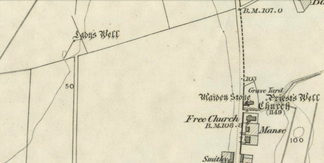
My initial thoughts about this holy well, was that it had been destroyed—but thankfully I was wrong. It had been intruded upon by roadworks along the B9140, with the original water source affected, but it was re-routed and can still be found below the south-side of the main road. It was highlighted on the 1866 Ordnance Survey map of the area When the Royal Commission (1933) lads visited the site in 1927 they told that,
“It has no features of special interest. It is 4′ in diameter, but is so much filled up with stones and debris that it is now not more than 2′ deep.”
The site was mentioned in Ruth & Frank Morris’ (1982) survey, but with no additional information. I’ve not been able to find out whether the ‘lady’ of this well was a saintly woman of religious importance, or just one of us commoners! Does anyone know?
Royal Commission on the Ancient & Historical Monuments, Scotland, Inventory of Monuments and Constructions in the Counties of Fife, Kinross and Clackmannan, HMSO: Edinburgh 1933.
From the lovely village of Kinloch Rannoch, take the south road over the river that heads (eventually) to Aberfeldy. 3-400 yards along, another small road meets with the one you’re on, on your right. Stop here! Then look across at the field ahead of you, on your left, and you’ll see a small standing stone amidst the green. That’s it!
Archaeology & History
This is a small, squat but impressive standing stone, less than 4 feet tall, set amidst a beautiful landscape which catches the eye in every direction. Found close to the remains of several prehistoric cairns, it seems probable that funerary associations would have happened here, although direct evidence is lacking.
Folklore
Clach na Boile, looking south
Although I can find nothing specific to account for the Gaelic meaning (“stone of fury”) of the monolith, on the other side of the road in the trees is the old house of Innerhadden, where a curious ghost story told how an old inhabitant there was helped by the spirit of one who died in the Battle of Culloden. (Cunningham 1989)
References:
Cunningham, A.D., Tales of Rannoch, Perth & Kinross District Library 1989.
A little-known early christian relic found in the driveway to East Riddlesden Hall was saved and propped up in the stable floor at the back. In 1984 however, the National Trust got round to moving it and bringing the relic to greater public attention by putting it on display in the great hall of the building. (I think you’ve gotta pay to go in and see the stone these days – which is a bittova pain if you just want to examine the carving)
Old photo of the carved stone (after Margaret Faull)
Measuring just 1 foot across and 2 feet high and carved on all sides, the design is all too familiar to those of you exploring early christian or late-Celtic art forms. Executed sometime between the 5th-10th century, on the main face of the cross we have the traditional ‘Celtic’ interlacing, with a bird-figure emerging on or around an early ‘cross’ symbol. There are a variety of interpretations of this, but none relate to any modern christian mythic structures. Indeed, we should cautiously reflect on the more pre-christian nature of this design: carved as it was at a time when the spirit of the natural world (animism) was endemic amongst all people. This carving would in some way reflect such implicit subjectivity, though perhaps have had emergent ideals relevant to the christian cult within it. However, we should be cautious about this christian idea, despite it being much in vogue by prevailing groups of consensus trance historians.
References:
Faull, Margaret L., “The Display of the Anglo-Saxon Crosses of the Keighley Area,” in Transactions of the Ancient Monuments Society, New Series no.30, 1986.
From Clackmannan Main Street, go down the Cattle Market and straight across at the junction, downhill. Keep going on the country lane for half-a-mile watching out for Grassmainston Farm on the left. Go past here and up the next dirt-track for a few hundred yards, watching out for a copse of trees on your left a coupla hundred yards away. Go to the very top corner of the copse, following the stream to its source. That’s it!
Archaeology & History
In a truly fascinating historical case of witchcraft (there was a lot of it in this area according to court and church records), heard in Clackmannan on 16th July, 1700, a certain spring of water, or well, was described, where acts of healing and sympathetic magick were performed and, it would seem, was quite well known to the people cited in the case. It seems very likely from reading the account, that the well in question had magical repute locally. The well was not named, but thankfully the information in the case has allowed us to identify the place in question. When I came here a month or two ago, the well was very overgrown (hence the poor photo above), so I’m gonna go back for another look at the place when Winter’s brushed back the vegetation.
The tale surrounding the well was included in Simpkin’s (1914) Folklore Society survey of Fife and Clackmannan a hundred years ago, and is as follows:
“John Scobie, younger, in Clackmannan, was called, who being of age thirty-eight, was sworn and interrogated if he went up with his uncle to a south-running well at Grassmainston. Deponed that he did go up with him, alone, the first night, and as his uncle was casting off his clothes at the well, the deponent saw a black man …coming from Kersemill; and when he came to the head of Robert Stupart’s folds there was a great squealing among the cattle. Also, when deponent had his uncle down to sprinkle him, he saw a brindled cat come out from among the corn within a little distance from him. He put magic powders upon his uncle when he was naked, which he had received from his said uncle’s wife, Margaret Bruce, who remarked to the deponent that the woman who directed (them), “would get a flee before he came back”; and that, at his return, at Goldney, he heard a terrible noise as of coaches, and that he was dripping of sweat when he came into the house.
“The said Margaret had forbidden them to speak in going or coming, which injunction they observed. When they came to call the deponent to go the second night he refused, till the deceased Robert Reid came and took him, and they both went with him, and saw the black man and the cat, and heard the cattle squeal as aforesaid and, when they were coming back again, there came a great wind upon the trees on the side of the Devon and, when he was crossing the Cartechy Burn his uncle’s foot slipped and he fell in the burn. Thereupon Robert Reid said, “The cure is lost. There is no helping of you now!” And so they spoke from thenceforth until they came home; for Margaret Bruce, the said James Scobie’s wife, told them that if he fell into the water he would not be cured. The witness further added that when they told Margaret that her husband had fallen into the water, she wept. ”
The magickal well in this case would appear to be one identified at the very top of the small copse of trees immediately north of Grassmainston farmhouse, just 3-400 hundred yards away up the slope. It is a “south-running well” as cited in the case and no other water source is immediately apparent. It would be good if any students or antiquarians living near Alloa could check local library records and see if there’s any further information about this site. A short distance north of here is the curiously-named ‘Serpent Wood’, with its old well, fallen stone and lost legends…
…to be continued…
References:
Simpkins, John Ewart, County Folklore – volume VII: Examples of Printed Folk-Lore Concerning Fife, with some Notes on Clackmannan and Kinross-Shires, Folk-Lore Society: London 1914.