Simply what the term suggests: upright singular or multiple sets of stones plonked there thousands of years back (traditionally betwixt neolithic to Iron Age) for various uses. Some relate to burial; others to land-markers (tribal boundaries, etc); some may be alignment-markers (solar and lunar); others simple meeting spots (moots). They are closely related to stone circles, tombs, and many of them are outliers to such sites.
Standing Stone (destroyed): OS Grid Reference – NS 855 507
Archaeology & History
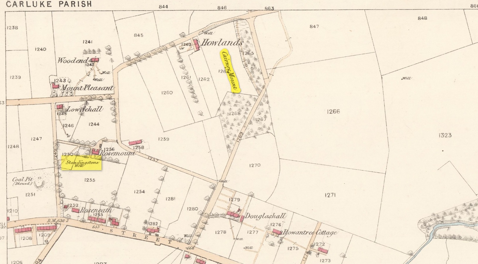
The Well & the field-name on the 1860 OS-map
An ancient standing stone on the eastern side of Carluke isn’t something that most local people are aware of. Sadly it’s long gone, but we find what seems to be a reference to it, both in the place-name Stanistone Road and the adjacent Standing Stone Well. The monolith would seem to have stood immediately east of the well, as a description of it by Rev John Wylie (1845) in the New Statistical Account (1845) indicates. Wylie told us that:
“Till lately, one of those remarkable monuments of antiquity, called standing stones, stood at Cairney Mount; but the hope of finding a hidden treasure induced some rude hand to destroy it.”
Cairney Mount is a field-name 300 metres east of the well, so it would seem highly likely there was an association between them, and the stone obviously stood somewhere between these two points.
References:
Royal Commission on the Ancient & Historical Monuments of Scotland, Lanarkshire: An Inventory of the Prehistoric and Roman Monuments, HMSO: Edinburgh 1978.
Wylie, John, “Parish of Carluke,” in New Statistical Account of Scotland – volume 6: Lanarkshire, William Blackwood: Edinburgh 1845.
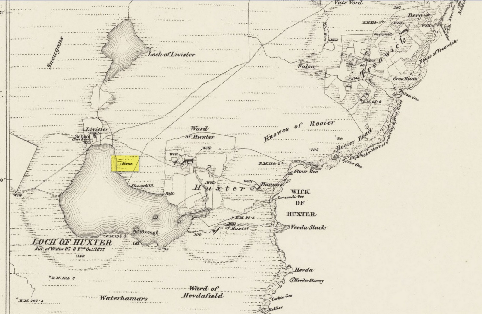
Standing Stone (destroyed): OS Grid Reference – HU 5577 6237
Archaeology & History
Site shown on 1882 map
Highlighted on both the 1880 (25-inch) and 1882 (6-inch) Ordnance Survey maps, this is another one of our ancient stones that has bitten the dust, so to speak. Local folk said that it stood about five feet tall, but when the Royal Commission doods visited the place in 1935, it had gone. They were told that it had been “broken up for building purposes in about 1912.” No traditions were known of it.
References:
Royal Commission Ancient & Historical Monuments, Scotland, Inventory of the Ancient Monuments of Orkney and Shetland – volume 3, HMSO: Edinburgh 1946.
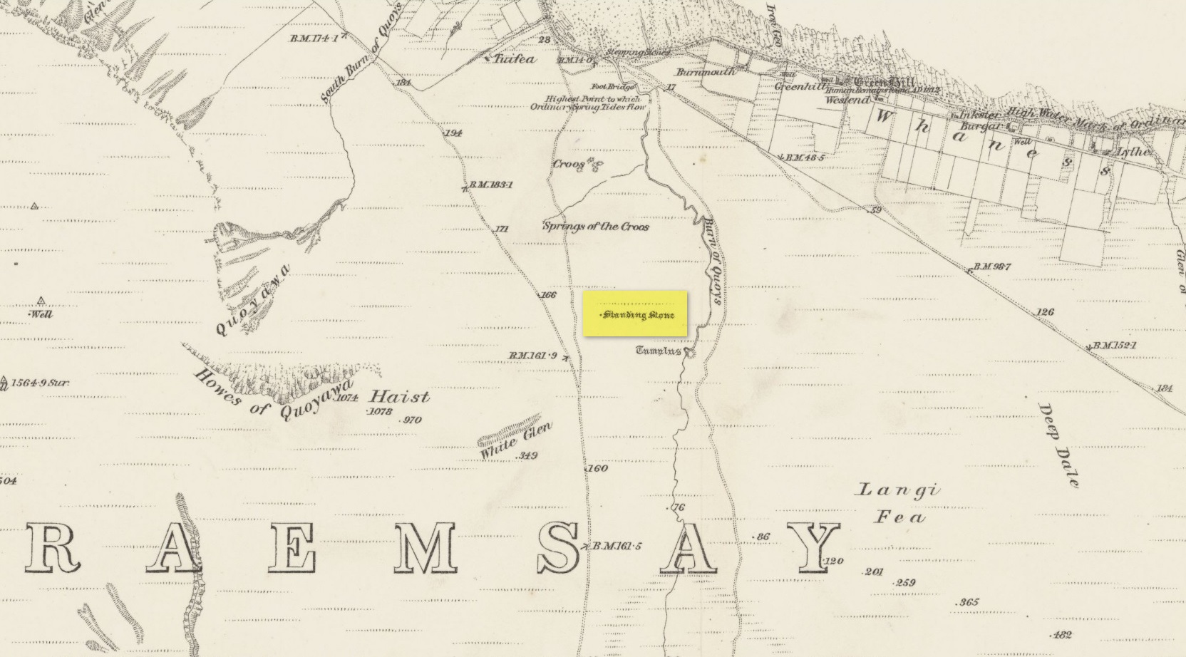
Standing Stone (destroyed): OS Grid Reference – HY 2435 0221
Archaeology & History
Highlighted on the 1882 Ordnance Survey map of the region (right), it was recorded in the Name Book a couple of years earlier as simply “a small unrecorded standing stone.” When the Royal Commission (1946) lads visited the site in 1929 they found that “this stone has been removed.” It had stood close to a prehistoric burial mound. Enquiries with local people about the stone proved unsuccessful. Does anyone know more about this?
References:
Royal Commission Ancient & Historical Monuments, Scotland, Inventory of the Ancient Monuments of Orkney and Shetland – volume 2, HMSO: Edinburgh 1946.
Royal Commission Ancient & Historical Monuments, Scotland, The Archaeological Sites and Monuments of Hoy and Waas, Edinburgh 1989.
Standing Stones (destroyed): OS Grid Reference – HY 497 509
Archaeology & History
These long lost standing stones most probably played a part in some ritual acts performed by the Orkney people until relatively recent times. Whilst their simple description doesn’t tell us this, the folklore of the adjacent body of water strongly suggests it. The stones were visited at the end of the 17th century by the antiquarian John Brand (1701) from whom we gain the only known account. He told that,
“At the north-east side of (St Tredwell’s) loch, nigh to the chapel, there is a high stone standing, behind which there is another stone lying hollowed in the form of a manger, and nigh to this there is another high stone standing with a round hole through it, for what use these stones served, we could not learn; whether for binding the horses of such to them as came to the chapel, and giving them meat in the hollow stone, or for tying the sacrifices to, as some say, in the times of Pagan idolatry, is uncertain.”
Several other hold stones are found in Orkney, some of which had lore that was thankfully recorded. We don’t know when these stones were torn down, but there is the possibility that they may have been cast into the loch alongside which they stood.
Folklore
An intriguing piece of folklore relates to the adjacent St Tredwell’s Loch, right next to the stones. The loch was known of far and wide as possessing great healing properties which Mr Brand told to be distinctly pagan in nature. St Tredwell’s church had a cairn of stones by its side and those who visited here would pick one up and cast it into the loch as an offering (some folk would cast money), so that its waters would heal that person’s ailment. According to Brand and the local minister, such cures were numerous. The narrative is truly fascinating. Brand told us that,
“nigh to the east end of which this chapel is, is held by the people as medicinal, whereupon many diseased and infirm persons resort to it, some saying that thereby they have got good; as a certain gentleman’s sister upon the isle, who was not able to go to this loch without help, yet returned without it; as likewise a gentleman in the country who was much distressed wifh sore eyes, went to this loch, and washing there became sound and whole, though he had been at much pains and expense to cure them formerly. With both which persons he who was minister of the place for many years was well acquainted, and told us that he saw them both before and after the cure. The present minister of Westra told me that such as are able to walk, use to go so many times about the loch as they think will perfect the cure, before they make any use of the water, and that without speaking to any, for they believe that if they speak this will marr the cure: also he told that on a certain morning not long since he went to this loch and found six so making their circuit, whom with some difficulty he obliging to speak, said to him they came there for their cure.”
The reason that I’ve included this folklore to the site profile of the monoliths is that, at some time in the early past the stones would most almost certainly have played some part in the ritual enacted at the loch by which they stood. The building of Tredwell’s chapel was, quite obviously, an attempt to mark the place as christian in nature; but in such a remote region, old habits truly died hard. Of particular interest in the rituals described here is the element of silence. It’s fascinating inasmuch as it’s an integral ingredient in various ritual magick performances in different parts of the world. Even in some modern magickal rites, this is still vitally important. It’s a tradition also found at other lochs in Scotland and at lakes in many other parts of the world.
Standing Stone (destroyed?): OS Grid Reference – HY 3347 0450
Archaeology & History
Very little seems to be known of this long lost standing stone, that appears to have been described just once in 19th century notebooks of the Orcadian lawyer and antiquarian, George Petrie. Therein he told how,
“Mr Balfour of Balfour and Trenabie described to me a ball of freestone found close to a Standing Stone on the farm of the Bu of Orphir and near to the churchyard.”
Despite being reported as “destroyed” by the Royal Commission (1946) lads, recently a local man claims to have found what he thinks might be the missing stone, about 400 yards to the southwest, very close to the coast and standing some six feet tall. We await a secondary local report on this.
References:
Royal Commission Ancient & Historical Monuments, Scotland, Inventory of the Ancient Monuments of Orkney and Shetland – volume 2, HMSO: Edinburgh 1946.
Standing Stone (destroyed): OS Grid Reference – HY 3035 1136
Archaeology & History
Very little is known of this standing stone that existed just a half-mile south of the major Stones of Stenness (to which it may have had some archaeo-linear relationship; or perhaps with the Brodgar circle a further half-mile away). It was destroyed sometime around 1860, with no description of its dimensions or appearance. When it was mentioned briefly by J. Fraser (1926), he told us that the position of the stone had subsequently been marked “by a wooden stake in the boggy land close to and north-east of Kethesgeo.”
References:
Fraser, J. “Antiquities of Stenness Parish”, in Proceedings Orkney Antiquarian Society, volume 4, 1926.
Royal Commission Ancient & Historical Monuments, Scotland, Inventory of the Ancient Monuments of Orkney and Shetland – volume 2, HMSO: Edinburgh 1946.
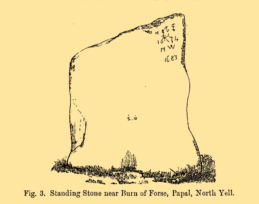
Standing Stone (destroyed): OS Grid Reference – HP 5378 0425
Also Known as:
The Brough
Archaeology & History
This standing stone formerly stood close to the Burn of Forse, otherwise known as the Garth of Papal in the far north of the island. Described briefly in J.T. Irving’s (1887) essay on the prehistoric remains of the area, the upright was obviously of local stone being,
Papil stone (PSAS 1887)
“a broad flat slab, slightly lower at one side than the other and measuring 4 feet 2 inches in greatest height by 2 feet 10 inches in width, and varying from 18 inches to 6 inches in thickness. In one corner were the initials H I 1674 and M W 1683, with an old merchant’s mark, or something of that description… The late Dr Hunt of the Anthropological Society, dug under it in 1865, with the result that it was left to fall down, and be eventually broken up for building material to be used in the walls of a new school-house.”
Folklore
Irving (1887) told us that, “there is a tradition that a queen who came in a ship to Papal died there, and was buried beneath this stone.”
References:
Irving, J.T., “Notes on some Prehistoric Burial-places and Standing Stones in the Island of Yell, Shetland”, in Proceedings Society Antiquaries, Scotland, volume 21, 1887.
Royal Commission Ancient & Historical Monuments, Scotland, Inventory of the Ancient Monuments of Orkney and Shetland – volume 3, HMSO: Edinburgh 1946.
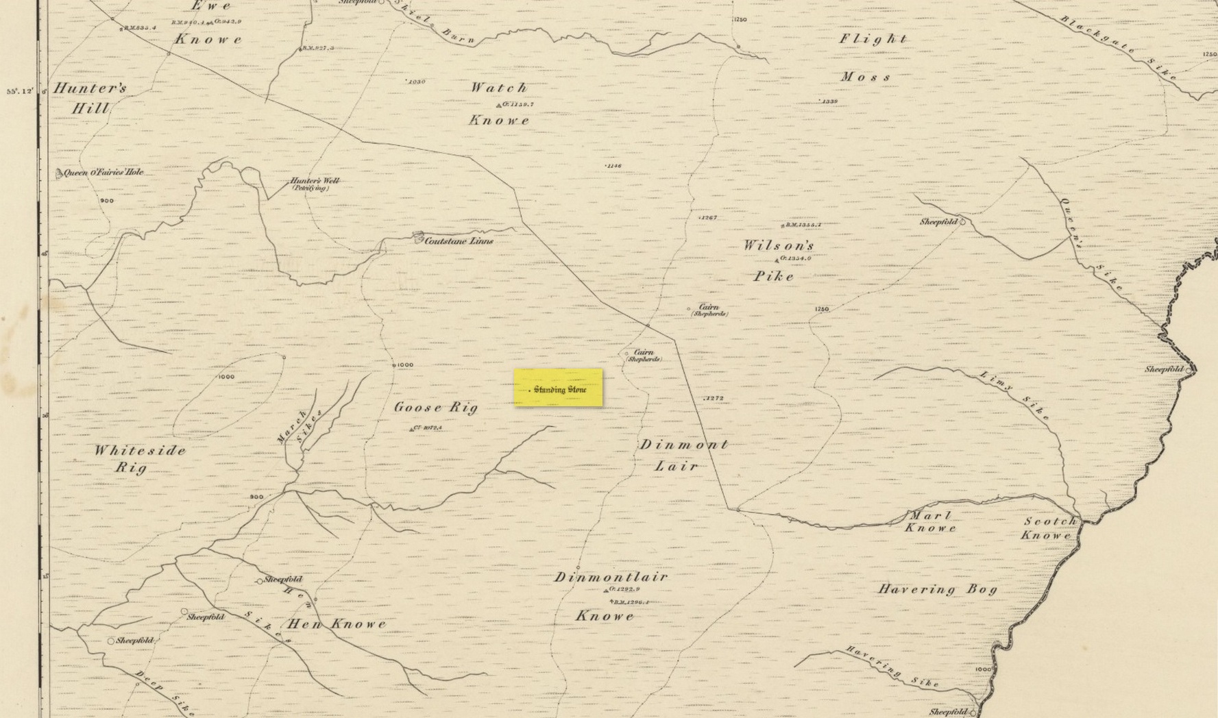
Standing Stone (destroyed): OS Grid Reference – NY 546 889
Archaeology & History
Stone shown on 1863 map
Once found living on the high moors four miles to the east of Newcastleton, close to the English border, all trace of the stone has gone. Highlighted on the 1863 OS-map, the stone was three feet high and was located at the highest end of Goose Rig. It was deemed by local people “to be of ancient origin,” but we know little else about it. A place immediately to the northwest is known as the Queen o’ Fairies Hole, whose history and folklore has also been forgotten…
References:
Royal Commission on the Ancient & Historical Monuments of Scotland, Roxburghshire – volume 1, HMSO: Edinburgh 1956, p.95
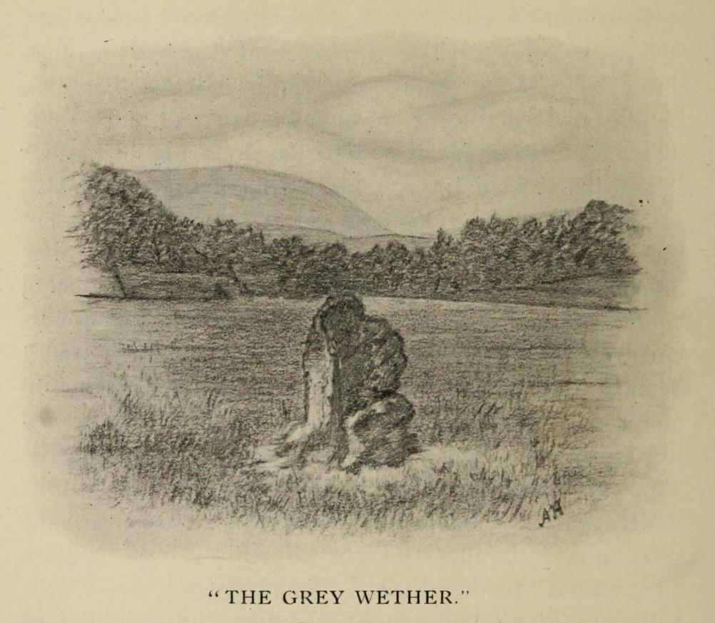
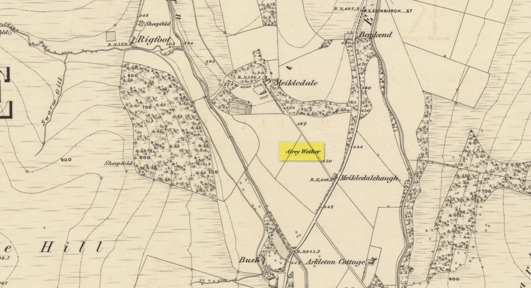
This is a site that requires the attention of some local antiquarians, as there are conflicting reports as to whether or not it still lives in its old haunt. Very little has been written about it and its whereabouts seems to have been completely missed in the radars of all megalithic guides. The Langholm historians—John and Robert Hyslop (1912)—who wrote about the place in their gigantic history work more than a hundred years ago, would no doubt be shaking their heads at such lackings.
They told:
“The best example of the standing stones in the Eskdale district is that at Meikledale in Ewes, locally known as ” The Grey Wether,” a print of which is here given. It is about 5 feet in height and its girth is 8 feet 7 inches, and it would probably weigh about two tons. The stone is the common greywacke, or whinstone of the Silurian series, rough and unhewn. It stands in the centre of a field in front of Meikledale House, and can be seen from the highway. The field is surrounded by hills on every side,”
which the writers thought might have been the reason for its erection here, although having more to do with the natural beauty of the landscape than any archaeocentric or geomantic factor.
Shortly after this had been written, Alexander Curle of the Royal Commission visited the area and made note of this “standing stone known as the Grey Wether…situated on the haughland some 250 yds SSE of Meikledale”, but added nothing more. It was several years later before a Royal Commission (1920) team came here and told that,
“A standing-stone, known as the “Grey Wether,” is situated on the haugh-land, some 250 yards south-south-east of Meikledale. It is a large whinstone slab, measuring in greatest height 4 feet 8 inches, in breadth 3 feet 5 inches, and in thickness 1 foot, and faces west-south-west and east-north-east.”
Stone shown on 1857 map
But they subsequently reported that, prior to World War 2, some complete dickhead knocked it down, broke it up and dumped it in a nearby stream! However, in 1980 some more lads from the Scottish Royal Commission revisited the area and alleged that a stone laid in the field 250 yards below of Meikledale farmhouse was our old Grey Wether. The position they describe is the same spot as the one shown on the 1857 OS-map; and at this very spot on GoogleEarth it seems that a stone there lies… Are there are any local folk in that neck o’ the woods who could find out…?
Folklore
The Greywethers stone circle on Dartmoor has a veritable mass of folklore attached to it, but its namesake here at Langholm has very little. The origin of its name has been forgotten. All we have left is what the Ordnance Name Book in 1857 recorded, telling that “it is supposed to have been erected in memory of some Hero, but no further account of it can be obtained.”
The first that I read of this place was in an article of the Scottish Ecclesiastical Society journal, on the parish history of Horndean. Standing originally at the edge of the ruined remains of the old churchyard, the author W.S. Moodie (1915), told that a long lost,
“grim relic of olden days is said to have existed here till fifty years ago. This was the Witches Stone—an upright pillar with a hole in it, to which the bodies of the poor unfortunates were fastened after they had been glede, while the faggots were piled around.”
A perusal in the Royal Commission inventory (1915) of the same year told that it had been moved several miles northeast to Paxton Cottage (NT 9279 5229) in the adjacent village. It was described as being,
“about 4 feet 6 inches in height above the ground, some 2 feet in breadth, tapering towards the upper end, and about 7 inches thick. Near the top are two perforations, not quite on the same level, about 2 inches in diameter at the surface on either side, constricted towards the Centre, and about 9 inches distant from centre to centre.”
Is this old stone still in existence…?
References:
Moodie, W. Steven, “Ladykirk, or the Kirk of Steill, Berwickshire,” in Transactions of the Scottish Ecclesiological Society, 4:3, Aberdeen 1915.
Royal Commission Ancient & Historical Monuments, Scotland, Inventory of Monuments and Constructions in the County of Berwick, HMSO: Edinburgh 1915.